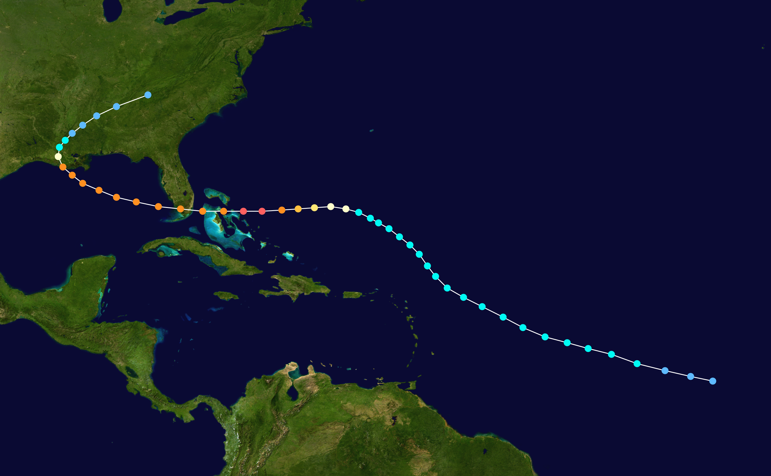
ATL: JOAQUIN - Post-Tropical - Discussion
Moderator: S2k Moderators
- Ivanhater
- Storm2k Moderator

- Posts: 11221
- Age: 39
- Joined: Fri Jul 01, 2005 8:25 am
- Location: Pensacola
Re: ATL: JOAQUIN - Hurricane - Discussion
I am curious to know the analogs of hurricanes coming up from this area and bending west into NC/VA. This might be a better suited question for Larrywx, but I am curious to know are they typically strengthening or weakening bending to the west into NC/VA?
0 likes
Michael
- Miami Storm Tracker
- Category 4

- Posts: 916
- Age: 68
- Joined: Sun Jun 13, 2010 10:12 pm
- Location: Key Largo, Fla.
- Contact:
Re: ATL: JOAQUIN - Hurricane - Discussion
cfltrib wrote:Although conditions this week seem to indicate a turn to the north before getting deep into the Bahamas, my old novice mind remembers Betsy in 1965, and Andrew in 1996 were both expected to turn to the north from approximately the same area.
A little old school you don't here people take about storms that far back now days Lol, I was in Key West when that one hit.
0 likes
- tropicwatch
- Category 5

- Posts: 3426
- Age: 62
- Joined: Sat Jun 02, 2007 10:01 am
- Location: Panama City Florida
- Contact:
ATL: JOAQUIN - Models
Appears to be still moving wsw, center is well below 25N approaching 24N it looks like..


Last edited by tropicwatch on Wed Sep 30, 2015 11:40 am, edited 2 times in total.
0 likes
Tropicwatch
Agnes 72', Eloise 75, Elena 85', Kate 85', Charley 86', Florence 88', Beryl 94', Dean 95', Erin 95', Opal 95', Earl 98', Georges 98', Ivan 2004', Arlene 2005', Dennis 2005', Ida 2009' Debby 2012' Irma 2017' Michael 2018'
Agnes 72', Eloise 75, Elena 85', Kate 85', Charley 86', Florence 88', Beryl 94', Dean 95', Erin 95', Opal 95', Earl 98', Georges 98', Ivan 2004', Arlene 2005', Dennis 2005', Ida 2009' Debby 2012' Irma 2017' Michael 2018'
Re: ATL: JOAQUIN - Hurricane - Discussion
cfltrib wrote:Although conditions this week seem to indicate a turn to the north before getting deep into the Bahamas, my old novice mind remembers Betsy in 1965, and Andrew in 1996 were both expected to turn to the north from approximately the same area.
Andrew in 1992 was always forecast to turn back west
0 likes
Re: ATL: JOAQUIN - Hurricane - Discussion
Ivanhater wrote:I am curious to know the analogs of hurricanes coming up from this area and bending west into NC/VA. This might be a better suited question for Larrywx, but I am curious to know are they typically strengthening or weakening bending to the west into NC/VA?
From the above comment

0 likes
- tropicwatch
- Category 5

- Posts: 3426
- Age: 62
- Joined: Sat Jun 02, 2007 10:01 am
- Location: Panama City Florida
- Contact:
Appears to be still moving wsw, center is well below 25N approaching 24N it looks like..


0 likes
Tropicwatch
Agnes 72', Eloise 75, Elena 85', Kate 85', Charley 86', Florence 88', Beryl 94', Dean 95', Erin 95', Opal 95', Earl 98', Georges 98', Ivan 2004', Arlene 2005', Dennis 2005', Ida 2009' Debby 2012' Irma 2017' Michael 2018'
Agnes 72', Eloise 75, Elena 85', Kate 85', Charley 86', Florence 88', Beryl 94', Dean 95', Erin 95', Opal 95', Earl 98', Georges 98', Ivan 2004', Arlene 2005', Dennis 2005', Ida 2009' Debby 2012' Irma 2017' Michael 2018'
Re: ATL: JOAQUIN - Hurricane - Discussion
Ivanhater wrote:I am curious to know the analogs of hurricanes coming up from this area and bending west into NC/VA. This might be a better suited question for Larrywx, but I am curious to know are they typically strengthening or weakening bending to the west into NC/VA?
Dean in 1983 http://weather.unisys.com/hurricane/atl ... /track.gif
This hook track is not unprecedented
0 likes
-
TimeZone
Western side still doesn't look very impressive. Convection looks flat, almost like somebody came down and squashed it. Also good news that the NHC is forecasting this thing to weaken at an extremely rapid pace before landfall. It certainly doesn't appear to be undergoing RI yet to my naked eyes which is also good news.
0 likes
-
AutoPenalti
- Category 5

- Posts: 4091
- Age: 29
- Joined: Mon Aug 17, 2015 4:16 pm
- Location: Ft. Lauderdale, Florida
Andrew

Betsy


Betsy

Last edited by AutoPenalti on Wed Sep 30, 2015 11:44 am, edited 1 time in total.
0 likes
The posts in this forum are NOT official forecasts and should not be used as such. They are just the opinion of the poster and may or may not be backed by sound meteorological data. They are NOT endorsed by any professional institution or STORM2K. For official information, please refer to products from the NHC and NWS.
Model Runs Cheat Sheet:
GFS (5:30 AM/PM, 11:30 AM/PM)
HWRF, GFDL, UKMET, NAVGEM (6:30-8:00 AM/PM, 12:30-2:00 AM/PM)
ECMWF (1:45 AM/PM)
TCVN is a weighted averaged
-
cfltrib
- Tropical Low

- Posts: 24
- Age: 72
- Joined: Sun Jun 24, 2012 3:06 pm
- Location: Hayesville, NC, formerly FL
Re: ATL: JOAQUIN - Hurricane - Discussion
The overall shape of the storm seems to be moving west, but the center is wobbling southward in this series:
http://wwwghcc.msfc.nasa.gov/cgi-bin/get-goes?satellite=GOES-E%20CONUS&lat=25&lon=-71&info=ir&zoom=1&width=1000&height=800&quality=90&type=Animation&palette=ir3.pal&numframes=20&mapcolor=gray
http://wwwghcc.msfc.nasa.gov/cgi-bin/get-goes?satellite=GOES-E%20CONUS&lat=25&lon=-71&info=ir&zoom=1&width=1000&height=800&quality=90&type=Animation&palette=ir3.pal&numframes=20&mapcolor=gray
0 likes
Re: ATL: JOAQUIN - Hurricane - Discussion
Isabel of 2003 I think might end up being the closest analog.
http://weather.unisys.com/hurricane/atlantic/2003/ISABEL/track_s.gif
http://weather.unisys.com/hurricane/atlantic/2003/ISABEL/track_s.gif
0 likes
- 1900hurricane
- Category 5

- Posts: 6063
- Age: 34
- Joined: Fri Feb 06, 2015 12:04 pm
- Location: Houston, TX
- Contact:
Deeper convection in the process of wrapping around the northern semicircle.

0 likes
Contract Meteorologist. TAMU & MSST. Fiercely authentic, one of a kind. We are all given free will, so choose a life meant to be lived. We are the Masters of our own Stories.
Opinions expressed are mine alone.
Follow me on Twitter at @1900hurricane : Read blogs at https://1900hurricane.wordpress.com/
Opinions expressed are mine alone.
Follow me on Twitter at @1900hurricane : Read blogs at https://1900hurricane.wordpress.com/
Re: ATL: JOAQUIN - Hurricane - Discussion
Alyono wrote:Ivanhater wrote:I am curious to know the analogs of hurricanes coming up from this area and bending west into NC/VA. This might be a better suited question for Larrywx, but I am curious to know are they typically strengthening or weakening bending to the west into NC/VA?
Dean in 1983 http://weather.unisys.com/hurricane/atl ... /track.gif
This hook track is not unprecedented
I thought Jeremy's example of Hanna was spot on. A little further east and south of where Joaquin is pretty close.
0 likes
Personal Forecast Disclaimer:
My posts are just my opinion and are most likely not backed by sound meteorological data. They are NOT endorsed by any professional institution or storm2k.org. For official information, please refer to the NHC and NWS products.
Bottom line is that I am just expressing my opinion!!!
My posts are just my opinion and are most likely not backed by sound meteorological data. They are NOT endorsed by any professional institution or storm2k.org. For official information, please refer to the NHC and NWS products.
Bottom line is that I am just expressing my opinion!!!
-
emeraldislenc
- Category 2

- Posts: 601
- Joined: Fri Aug 24, 2012 4:49 pm
- Location: Emerald Isle NC
Re:
TimeZone wrote:Western side still doesn't look very impressive. Convection looks flat, almost like somebody came down and squashed it. Also good news that the NHC is forecasting this thing to weaken at an extremely rapid pace before landfall. It certainly doesn't appear to be undergoing RI yet to my naked eyes which is also good news.
I am not seeing what you are seeing

0 likes
Re:
TimeZone wrote:Western side still doesn't look very impressive. Convection looks flat, almost like somebody came down and squashed it. Also good news that the NHC is forecasting this thing to weaken at an extremely rapid pace before landfall. It certainly doesn't appear to be undergoing RI yet to my naked eyes which is also good news.
Furthermore, the NHC discussion not only was very clear to indicate that confidence was very low regarding Joaquin's future track and speed of motion, but that such details could have huge ramifications regarding the potential impact that the storm could have if/when making landfall.
Stated in the discussion was:
"...the intensity forecast calls for
Joaquin to peak as a major hurricane in about 72 hours, and it is possible it could be stronger than currently forecast..." AND
"...Confidence in the details of the track forecast late in the
period remains low, since the environmental steering currents are
complex and the model guidance is inconsistent. A wide range of
outcomes is possible, from a direct impact of a major hurricane
along the U.S. east coast to a track of Joaquin out to sea away from
the coast.."
0 likes
Andy D
(For official information, please refer to the NHC and NWS products.)
(For official information, please refer to the NHC and NWS products.)
-
TimeZone
Re: Re:
Everytime this thing tries to expand it's heaviest convection to the Western side the cloud tops warm significantly. It's pretty obvious on that loop you posted as well. It's gaining strength I didn't deny that but I think it'll continue to gain strength at a more moderate pace. Shear will also increase as this thing gains latitude. Conditions right now are likely as good as they're going to get for this thing to intensify.
Personal Forecast Disclaimer:
The posts in this forum are NOT official forecast and should not be used as such. They are just the opinion of the poster and may or may not be backed by sound meteorological data. They are NOT endorsed by any professional institution or storm2k.org. For official information, please refer to the NHC and NWS products.
0 likes
Who is online
Users browsing this forum: No registered users and 44 guests


