ATL: JOAQUIN - Post-Tropical - Discussion

Moderator: S2k Moderators

Message
Author
ozonepete
Professional-Met
Professional-Met
Posts: 4743
Joined: Mon Sep 07, 2009 3:23 pm
Location: From Ozone Park, NYC / Now in Brooklyn, NY

Re: ATL: JOAQUIN - Hurricane - Discussion

#2201 Postby ozonepete » Thu Oct 01, 2015 7:56 pm

Blinhart wrote:I've been seeing recon numbers suggesting over 120 Kt. winds so that would put it up to 135 to 140 mph winds.


Yes, and that was expected due to the earlier pressure drop. But 140 mph is far from cat 5.
0 likes   

Chris_in_Tampa
Category 5
Category 5
Posts: 5075
Age: 41
Joined: Thu Jun 21, 2007 11:06 pm
Location: Tampa, Florida, USA
Contact:

Re: ATL: JOAQUIN - Recon

#2202 Postby Chris_in_Tampa » Thu Oct 01, 2015 7:57 pm

Image
0 likes   

User avatar
Hammy
Category 5
Category 5
Posts: 5849
Age: 41
Joined: Fri May 25, 2012 5:25 pm
Contact:

#2203 Postby Hammy » Thu Oct 01, 2015 7:59 pm

Satellite appearance is looking rather sickly for this being as strong as it is.
0 likes   
The above post is not official and should not be used as such. It is the opinion of the poster and may or may not be backed by sound meteorological data. It is not endorsed by any professional institution or storm2k.org. For official information, please refer to the NHC and NWS products.

User avatar
Cyclenall
Category 5
Category 5
Posts: 6666
Joined: Thu Jun 08, 2006 10:01 pm
Location: Ontario, Canada

Re: Re:

#2204 Postby Cyclenall » Thu Oct 01, 2015 8:01 pm

TheStormExpert wrote::uarrow: Usually with an ERC comes some weakening.

That's during.

Blinhart wrote:I definitely think it is a Cat 5 right now and once the eye gets its walls up and tight it will get close to record strength.

No.

ozonepete wrote:
TheStormExpert wrote::uarrow: Usually with an ERC comes some weakening.


You are right. When the eye-wall rep is first completed the winds are initially lower or steady. It is many hours after that that strengthening occurs again.

I never heard this before, it certainly did not happen that way when Hurricane Katrina completed her ERC on the morning of the 28th (many hours).
Last edited by Cyclenall on Thu Oct 01, 2015 8:04 pm, edited 1 time in total.
0 likes   

User avatar
johngaltfla
Category 5
Category 5
Posts: 2069
Joined: Sun Jul 10, 2005 9:17 pm
Location: Sarasota County, FL
Contact:

Re:

#2205 Postby johngaltfla » Thu Oct 01, 2015 8:02 pm

Hammy wrote:Satellite appearance is looking rather sickly for this being as strong as it is.


Somewhat normal during the completion of an ERC.
0 likes   

tolakram
Admin
Admin
Posts: 20009
Age: 62
Joined: Sun Aug 27, 2006 8:23 pm
Location: Florence, KY (name is Mark)

Re: ATL: JOAQUIN - Hurricane - Discussion

#2206 Postby tolakram » Thu Oct 01, 2015 8:02 pm

Live IR, looks like some new storms firing in the what may be the new eyewall.

http://wwwghcc.msfc.nasa.gov/cgi-bin/get-goes?satellite=GOES-E%20CONUS&lat=24&lon=-74&info=ir&zoom=1&width=1000&height=800&quality=90&type=Animation&palette=ir3.pal&numframes=15&mapcolor=gray

While waters near the Bahamas may be shallow I'm going to carefully disagree with lack of heat potential in the coming days. With good outflow and over record warm waters I think there is at least a small chance this could hit cat 5. Not likely, but not impossible IMO.

Image

source: http://rammb.cira.colostate.edu/products/tc_realtime/
0 likes   
M a r k
- - - - -
Join us in chat: Storm2K Chatroom Invite. Android and IOS apps also available.

The posts in this forum are NOT official forecasts and should not be used as such. Posts are NOT endorsed by any professional institution or STORM2K.org. For official information and forecasts, please refer to NHC and NWS products.

CrazyC83
Professional-Met
Professional-Met
Posts: 34002
Joined: Tue Mar 07, 2006 11:57 pm
Location: Deep South, for the first time!

#2207 Postby CrazyC83 » Thu Oct 01, 2015 8:02 pm

000
URNT15 KNHC 020101
AF300 0911A JOAQUIN HDOB 35 20151002
005030 2331N 07521W 6965 03051 9908 +119 +020 020054 054 035 001 00
005100 2330N 07519W 6971 03041 9910 +115 +022 020057 058 035 001 03
005130 2329N 07518W 6959 03052 9904 +115 +020 020058 059 038 001 00
005200 2327N 07517W 6966 03042 9900 +114 +026 020059 059 038 001 00
005230 2326N 07515W 6965 03037 9896 +111 +029 021062 063 039 001 03
005300 2325N 07514W 6969 03026 9894 +111 +028 021065 065 039 000 03
005330 2323N 07512W 6967 03023 9891 +109 +032 020065 066 040 000 00
005400 2322N 07511W 6964 03025 9883 +111 +031 023066 067 040 000 03
005430 2321N 07509W 6974 03007 9872 +115 +029 021069 070 048 000 03
005500 2320N 07507W 6958 03011 9874 +109 +034 020072 074 050 001 03
005530 2318N 07506W 6974 02983 9861 +109 +036 019076 077 /// /// 03
005600 2317N 07504W 6960 03003 9867 +100 +045 016077 079 056 001 00
005630 2316N 07503W 6967 02985 9871 +086 +049 014078 079 056 007 03
005700 2315N 07501W 6960 02987 9878 +075 +057 024075 079 052 026 03
005730 2314N 07459W 6978 02958 9856 +084 +066 032077 083 056 016 03
005800 2313N 07458W 6973 02961 9829 +101 +068 034087 092 060 012 03
005830 2313N 07456W 6951 02972 9819 +098 +064 032089 094 061 011 03
005900 2312N 07455W 6970 02941 9824 +084 +060 035096 099 062 016 03
005930 2311N 07453W 6974 02918 9814 +080 +063 033103 105 069 016 03
010000 2311N 07452W 6971 02911 9803 +076 +063 034108 114 070 018 00
$$
;

114 kt FL, 70 kt SFMR - and still a good distance to the eye. Hurricane wind field expanding greatly.
0 likes   

Ken Lucas
Tropical Low
Tropical Low
Posts: 31
Joined: Wed Sep 30, 2015 10:29 pm

Re: ATL: JOAQUIN - Hurricane - Discussion

#2208 Postby Ken Lucas » Thu Oct 01, 2015 8:04 pm

northjaxpro wrote:
GlennOBX wrote:Excuse the simple question, but with the talk about whether or not this gets west of 75°W and whether the models had predicted that it would, does anything change regarding the consensus forecast if Joaquin does get past 75° W?

Thanks


My feeling is that if Joaquin traverses past 75 degrees Longitude, there were no models having him get past that far west. The ridge that has been steering Joaquin imo has been a bit more stout than many expected and it pushed Joaquin much farther south and west than all the models had anticipated. That lends credence to the idea that the ridge has been underplayed and that Joaquin has reinforced the ridge steering him most of this week. Gatorcane and I discussed this at detail earlier today and I am beginning to think this has been the case all along. The main thing it is doing is delaying the northward turn for an unexpected lengthy time. Eventually, Joaquin will feel the steering flow of the developing cut-off Low over the Southeast U.S. and hopefully get booted out of the Bahamas region sooner hopefully rather than later for those suffering folks. Also, we have to watch closely to hope that the cut-off Low does not develop into an negatively tilted one. If it did that, that would put the possibility of U.S. effects back on the table. An NW to SE oriented negatively titled cut-off Low can possibly pull the tropical cyclone back toward it once Joaquin lifts past the latitude of the base of that tilted trough. This is why I am not ready to sound the all clear with Joaquin with regards to possible impacts along the Mid Atlantic and Noertheast U.S. At least, not for at least another 36 hous or so until we see how the trough finally will evolve.


Yikes, I hope that doesn't come into play.
0 likes   
Disclaimer:
My posts in this forum are NOT official forecast and should not be used as such. They are of my opinion and as such should NOT be treated as an official forecast. For official information, please refer to the NHC and NWS products.

User avatar
Hammy
Category 5
Category 5
Posts: 5849
Age: 41
Joined: Fri May 25, 2012 5:25 pm
Contact:

#2209 Postby Hammy » Thu Oct 01, 2015 8:06 pm

Provided the upper air remains favorable this may strengthen some as it moves away from the Bahamas, given the map.
0 likes   
The above post is not official and should not be used as such. It is the opinion of the poster and may or may not be backed by sound meteorological data. It is not endorsed by any professional institution or storm2k.org. For official information, please refer to the NHC and NWS products.

User avatar
bahamaswx
Category 5
Category 5
Posts: 1542
Joined: Sat Sep 13, 2003 1:11 am
Location: Georgetown, Bahamas

Re: ATL: JOAQUIN - Hurricane - Discussion

#2210 Postby bahamaswx » Thu Oct 01, 2015 8:07 pm

ozonepete wrote::uarrow: Lol, this will not make a cat 5. It doesn't have enough ideal conditions. For one, it is over very shallow water and because it's moving so slowly it has likely already sucked too much heat energy out of the water, i.e. there's not much fuel left so it has to move away from that area to another warm spot in order to intensify any more.


These were my thoughts as well, but in truth most of the large very shallow banks of the Bahamas occur in the NW Bahamas. Where he is now, there's still a lot of deeper water to work with.
0 likes   

floridasun78
Category 5
Category 5
Posts: 3755
Joined: Sun May 17, 2009 10:16 pm
Location: miami fl

#2211 Postby floridasun78 » Thu Oct 01, 2015 8:10 pm

cuba issue ts warring north coast of cuba
0 likes   

davidiowx
Category 1
Category 1
Posts: 390
Joined: Tue Sep 10, 2013 11:07 am
Location: Richmond, TX

Re: ATL: JOAQUIN - Hurricane - Discussion

#2212 Postby davidiowx » Thu Oct 01, 2015 8:10 pm

Perhaps Joaquin is starting to feel the ridge. I'd guess it starts to turn tonight/early morning. Just my opinion..
0 likes   

User avatar
weathernerdguy
Tropical Storm
Tropical Storm
Posts: 188
Age: 23
Joined: Wed Jul 10, 2013 8:44 pm

#2213 Postby weathernerdguy » Thu Oct 01, 2015 8:11 pm

ADT has a cat 5.
0 likes   
The posts in this forum are NOT official forecast and should not be used as such. They are just the opinion of the poster and may or may not be backed by sound meteorological data. They are NOT endorsed by any professional institution or storm2k.org. For official information, please refer to the NHC and NWS products

CrazyC83
Professional-Met
Professional-Met
Posts: 34002
Joined: Tue Mar 07, 2006 11:57 pm
Location: Deep South, for the first time!

#2214 Postby CrazyC83 » Thu Oct 01, 2015 8:13 pm

000
URNT15 KNHC 020109
AF300 0911A JOAQUIN HDOB 36 20151002
010030 2310N 07451W 6956 02909 9784 +074 +061 031109 118 070 022 03
010100 2309N 07449W 6953 02889 9749 +083 +062 031097 117 067 040 03
010130 2308N 07448W 6996 02822 9707 +106 +077 031096 098 086 015 00
010200 2308N 07446W 6958 02858 9665 +129 +088 038099 100 087 003 00
010230 2307N 07445W 6965 02827 9633 +141 +079 040101 102 087 003 03
010300 2306N 07443W 6966 02799 9611 +134 +076 041100 102 091 001 00
010330 2305N 07442W 6962 02774 9583 +132 +081 043105 106 093 002 00
010400 2304N 07441W 6976 02725 9538 +146 +086 046106 107 092 002 03
010430 2303N 07440W 6981 02696 9485 +169 +084 045100 105 094 000 00
010500 2302N 07438W 6960 02692 9458 +164 +083 040095 096 093 000 00
010530 2301N 07437W 6957 02661 9430 +157 +082 043088 096 090 001 00
010600 2300N 07436W 6974 02620 9411 +157 +089 051069 079 085 002 03
010630 2300N 07434W 6958 02634 9402 +153 +097 059055 063 063 001 03
010700 2259N 07433W 6970 02603 9380 +163 +091 067047 054 050 003 00
010730 2257N 07432W 6967 02601 9376 +161 +076 061038 043 033 001 03
010800 2255N 07431W 6962 02601 9375 +156 +064 053031 036 017 002 03
010830 2254N 07430W 6977 02577 9379 +147 +075 048019 027 008 001 03
010900 2252N 07429W 6967 02585 9370 +154 +081 048007 018 009 000 00
010930 2251N 07427W 6971 02581 9377 +144 +093 246006 010 010 000 03
011000 2250N 07426W 6966 02587 9372 +150 +097 233018 020 012 002 00
$$
;

118 kt FL, 94 kt SFMR in NW quad. Notice the double wind maxima.
0 likes   

User avatar
NDG
S2K Supporter
S2K Supporter
Posts: 15446
Joined: Sun Jul 09, 2006 10:14 pm
Location: Orlando, FL

#2215 Postby NDG » Thu Oct 01, 2015 8:13 pm

Recon just found that Joaquin's pressure has risen a little.
0 likes   

tolakram
Admin
Admin
Posts: 20009
Age: 62
Joined: Sun Aug 27, 2006 8:23 pm
Location: Florence, KY (name is Mark)

Re:

#2216 Postby tolakram » Thu Oct 01, 2015 8:14 pm

weathernerdguy wrote:ADT has a cat 5.


Source and numbers?
0 likes   
M a r k
- - - - -
Join us in chat: Storm2K Chatroom Invite. Android and IOS apps also available.

The posts in this forum are NOT official forecasts and should not be used as such. Posts are NOT endorsed by any professional institution or STORM2K.org. For official information and forecasts, please refer to NHC and NWS products.

TheStormExpert

#2217 Postby TheStormExpert » Thu Oct 01, 2015 8:14 pm

Any chance this could still pull an Irene(2011) type track?
0 likes   

User avatar
NDG
S2K Supporter
S2K Supporter
Posts: 15446
Joined: Sun Jul 09, 2006 10:14 pm
Location: Orlando, FL

#2218 Postby NDG » Thu Oct 01, 2015 8:15 pm

In two hours if it moved 5 miles is a lot.
0 likes   

TheStormExpert

Re:

#2219 Postby TheStormExpert » Thu Oct 01, 2015 8:15 pm

NDG wrote:Recon just found that Joaquin's pressure has risen a little.

Doesn't surprise me, I'd say it already peaked.
0 likes   

ozonepete
Professional-Met
Professional-Met
Posts: 4743
Joined: Mon Sep 07, 2009 3:23 pm
Location: From Ozone Park, NYC / Now in Brooklyn, NY

Re: ATL: JOAQUIN - Hurricane - Discussion

#2220 Postby ozonepete » Thu Oct 01, 2015 8:16 pm

bahamaswx wrote:
ozonepete wrote::uarrow: Lol, this will not make a cat 5. It doesn't have enough ideal conditions. For one, it is over very shallow water and because it's moving so slowly it has likely already sucked too much heat energy out of the water, i.e. there's not much fuel left so it has to move away from that area to another warm spot in order to intensify any more.


These were my thoughts as well, but in truth most of the large very shallow banks of the Bahamas occur in the NW Bahamas. Where he is now, there's still a lot of deeper water to work with.
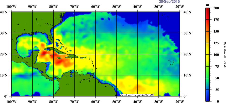

My bad to not explain it in more detail. I should have said it is over relatively shallow water where the Oceanic Heat content and depth of the 26C isotherm are not super high right now where they can support a cat 4 continuously. Here's the depth of the 26C isotherm (depth to which the water is 26C or better) in that area. It's about 100 meters. That's not enough to sustain this TC much longer.

Image
Last edited by ozonepete on Thu Oct 01, 2015 8:16 pm, edited 1 time in total.
0 likes   


Return to “2015”

Who is online

Users browsing this forum: No registered users and 10 guests