Live visible
http://wwwghcc.msfc.nasa.gov/cgi-bin/get-goes?satellite=GOES-E%20CONUS&lat=26&lon=-70&info=vis&zoom=1&width=1000&height=800&quality=90&type=Animation&palette=ir1.pal&numframes=20&mapcolor=gray
Live IR
http://wwwghcc.msfc.nasa.gov/cgi-bin/get-goes?satellite=GOES-E%20CONUS&lat=26&lon=-71&info=ir&zoom=2&width=1000&height=800&quality=90&type=Animation&palette=ir4.pal&numframes=15&mapcolor=gray
ATL: JOAQUIN - Post-Tropical - Discussion
Moderator: S2k Moderators
-
tolakram
- Admin

- Posts: 20179
- Age: 62
- Joined: Sun Aug 27, 2006 8:23 pm
- Location: Florence, KY (name is Mark)
Re: ATL: JOAQUIN - Hurricane - Discussion
0 likes
M a r k
- - - - -
Join us in chat: Storm2K Chatroom Invite. Android and IOS apps also available.
The posts in this forum are NOT official forecasts and should not be used as such. Posts are NOT endorsed by any professional institution or STORM2K.org. For official information and forecasts, please refer to NHC and NWS products.

Re: ATL: JOAQUIN - Hurricane - Discussion
Sanibel wrote:I think Joaquin went category 4-5 just on untapped energy alone.
Yeah and think becauses started to move into deeper new warm water...started to reduce as all energy transfer sucked out already from before and those shallow waters weren't able to sustain, especially when slowly moving!
Keep in mind it well may have been stronger than we thought yesterday eve as we only really see a limited amount of data readings for such a complex system...
0 likes
Disclaimer: while I am PhD who does research I'm rambling here so this post should be taken only for entertainment...use nhc.noaa.gov for official forecasts!
FLoridian living round here for a while: 2016 Matthew & 1998 Earl lived barrier island landfall. Also lived nearby/inland for: 2017 Irma & 2004 Frances,Jeanne & 1992 Andrew
FLoridian living round here for a while: 2016 Matthew & 1998 Earl lived barrier island landfall. Also lived nearby/inland for: 2017 Irma & 2004 Frances,Jeanne & 1992 Andrew
-
galaxy401

- Category 5

- Posts: 2446
- Age: 30
- Joined: Sat Aug 25, 2012 9:04 pm
- Location: Casa Grande, Arizona
Weaker.
HURRICANE JOAQUIN DISCUSSION NUMBER 25
NWS NATIONAL HURRICANE CENTER MIAMI FL AL112015
500 PM EDT SAT OCT 03 2015
The cloud pattern is not as impressive as it was earlier today,
but the eye continues to be distinct. Both objective and subjective
T-numbers are decreasing slightly, and on this basis, the initial
intensity has been set at 130 kt. Another plane will investigate
Joaquin in a few hours. Despite the observed intensification this
morning, the NHC forecast still calls for gradual weakening due to
increasing shear and cooler waters. Joaquin is forecast to become a
strong extratropical cyclone by the end of the forecast period.
Earlier reconnaissance data and current satellite fixes indicate
that Joaquin is moving toward the northeast or 045 degrees at 15
kt. The hurricane continues to be steered by the flow between an
eastward-moving trough over southeastern United States and a
weakening subtropical ridge over the western Atlantic. Joaquin is
forecast to turn more to the north-northeast as the trough swings
eastward. Then, in about 3 days, the hurricane will be fully
embedded in the mid-latitude flow and will turn to the northeast
with an increase in forward speed. The NHC forecast is very similar
to the previous one, primarily during the first 24 to 36 hours, and
is on top of the multi-model consensus and the consensus of the
ECMWF and the GFS models.
Although the confidence in the track forecast is quite high due to
the good model agreement, a small deviation to the east of the
forecast track would bring the core of the hurricane with stronger
winds to Bermuda.
FORECAST POSITIONS AND MAX WINDS
INIT 03/2100Z 27.0N 70.5W 130 KT 150 MPH
12H 04/0600Z 29.0N 68.7W 125 KT 145 MPH
24H 04/1800Z 31.5N 67.0W 110 KT 125 MPH
36H 05/0600Z 33.7N 66.0W 95 KT 110 MPH
48H 05/1800Z 36.0N 64.0W 80 KT 90 MPH
72H 06/1800Z 40.0N 56.0W 70 KT 80 MPH
96H 07/1800Z 45.0N 40.0W 60 KT 70 MPH...POST-TROP/EXTRATROP
120H 08/1800Z 50.0N 25.0W 60 KT 70 MPH...POST-TROP/EXTRATROP
$$
Forecaster Avila
0 likes
Got my eyes on moving right into Hurricane Alley: Florida.
Re:
galaxy401 wrote:If only there were recon, do any of you know the next mission?
They post schedule on nhc.noaa
and you can view it along with realtime from sidebar...next looks like 2300z
BTW while we're talking links can somebody share link to archive of last few runs Euro??
Thanks
0 likes
Disclaimer: while I am PhD who does research I'm rambling here so this post should be taken only for entertainment...use nhc.noaa.gov for official forecasts!
FLoridian living round here for a while: 2016 Matthew & 1998 Earl lived barrier island landfall. Also lived nearby/inland for: 2017 Irma & 2004 Frances,Jeanne & 1992 Andrew
FLoridian living round here for a while: 2016 Matthew & 1998 Earl lived barrier island landfall. Also lived nearby/inland for: 2017 Irma & 2004 Frances,Jeanne & 1992 Andrew
-
tatertawt24
- Category 1

- Posts: 309
- Joined: Wed Oct 24, 2012 12:57 pm
Re: ATL: JOAQUIN - Hurricane - Discussion
Looks like it's weakening again, so if it reached cat 5 it won't be recorded as such. This may also have happened with Opal, exactly twenty years ago.
0 likes
Personal Forecast Disclaimer:
The posts in this forum are NOT official forecast and should not be used as such. They are just the opinion of the poster and may or may not be backed by sound meteorological data. They are NOT endorsed by any professional institution or storm2k.org. For official information, please refer to the NHC and NWS products.
The posts in this forum are NOT official forecast and should not be used as such. They are just the opinion of the poster and may or may not be backed by sound meteorological data. They are NOT endorsed by any professional institution or storm2k.org. For official information, please refer to the NHC and NWS products.
-
USTropics
- Professional-Met

- Posts: 2737
- Joined: Sun Aug 12, 2007 3:45 am
- Location: Florida State University
Re: Re:
smithtim wrote:galaxy401 wrote:If only there were recon, do any of you know the next mission?
They post schedule on nhc.noaa
and you can view it along with realtime from sidebar...next looks like 2300z
BTW while we're talking links can somebody share link to archive of last few runs Euro??
Thanks
You can go back to Wednesday runs here - http://www.tropicaltidbits.com/analysis ... s=0&ypos=0
You can also go back 10 runs on the operational and ensembles at FSU's MM5 site - http://moe.met.fsu.edu/tcgengifs/
0 likes
-
tatertawt24
- Category 1
- Posts: 309
- Joined: Wed Oct 24, 2012 12:57 pm
Is the eye disappearing or is it just ridiculously small?
0 likes
Personal Forecast Disclaimer:
The posts in this forum are NOT official forecast and should not be used as such. They are just the opinion of the poster and may or may not be backed by sound meteorological data. They are NOT endorsed by any professional institution or storm2k.org. For official information, please refer to the NHC and NWS products.
The posts in this forum are NOT official forecast and should not be used as such. They are just the opinion of the poster and may or may not be backed by sound meteorological data. They are NOT endorsed by any professional institution or storm2k.org. For official information, please refer to the NHC and NWS products.


Re: ATL: JOAQUIN - Hurricane - Discussion
To my knowledge, even with the old Saffir-Simpson scale, 155 mph was the upper end of Cat 4, not Cat 5.ozonepete wrote:JtSmarts wrote:The storm2k map is wrong, it always processes a 155mph storm as a Cat 5. Check the NHC site, Joaquin is and has been a 155mph Cat 4 storm, it has to reach 156mph to be considered a cat 5.
Has to reach 157 mph now with new scale.
0 likes
-
ozonepete
- Professional-Met
- Posts: 4743
- Joined: Mon Sep 07, 2009 3:23 pm
- Location: From Ozone Park, NYC / Now in Brooklyn, NY
Re: ATL: JOAQUIN - Hurricane - Discussion
abajan wrote:To my knowledge, even with the old Saffir-Simpson scale, 155 mph was the upper end of Cat 4, not Cat 5.ozonepete wrote:JtSmarts wrote:The storm2k map is wrong, it always processes a 155mph storm as a Cat 5. Check the NHC site, Joaquin is and has been a 155mph Cat 4 storm, it has to reach 156mph to be considered a cat 5.
Has to reach 157 mph now with new scale.
Yup, buddy, you are correct. Used to be greater or equal to 156. Now greater or equal to 157. So 155 mph isn't, and was never, a cat 5.
0 likes

Re: ATL: JOAQUIN - Hurricane - Discussion
floridasun78 wrote:their 30 death long island in bahamasThere appears to be some fatalities on Long Island but waiting on confirmation...There are about 30 deaths in long island 8 confirmed.....
Most everyone who offers input through their posts here, are keenly aware of the very real impact and risks that tropical cyclones pose to those of us here in the U.S. Many of us, as well as a good number of other S2K members or followers from around the world however, may be less familiar or connected to the many who live throughout parts of Central America, the Greater and Lessor Antilles of the Caribbean, the Bahamas, or Bermuda. Needless to say, but the death, injuries, and destruction that Joaquin has caused in the Bahamas is very real. I (and many others here) enjoy the banter and discussion regarding the science of weather and especially tropical meteorology, but I think its important as well to not lose sight of the impact that these events can and do have on others. For that reason, I just wanted to take a moment and offer my condolence and thoughts to those of you in the Bahamas who were directly impacted by Hurricane Joaquin.
0 likes
Andy D
(For official information, please refer to the NHC and NWS products.)
(For official information, please refer to the NHC and NWS products.)
-
CrazyC83
- Professional-Met
- Posts: 34315
- Joined: Tue Mar 07, 2006 11:57 pm
- Location: Deep South, for the first time!
Re: ATL: JOAQUIN - Hurricane - Discussion
chaser1 wrote:floridasun78 wrote:their 30 death long island in bahamasMy heart goes out to all those in the Bahamas who have lost friends or family members as a result of Hurricane Joaquin.
Most everyone who offers input through their posts here, are keenly aware of the very real impact and risks that tropical cyclones pose to those of us here in the U.S. Many of us, as well as a good number of other S2K members or followers from around the world however, may be less familiar or connected to the many who live throughout parts of Central America, the Greater and Lessor Antilles of the Caribbean, the Bahamas, or Bermuda. Needless to say, but the death, injuries, and destruction that Joaquin has caused in the Bahamas is very real. I (and many others here) enjoy the banter and discussion regarding the science of weather and especially tropical meteorology, but I think its important as well to not lose sight of the impact that these events can and do have on others. For that reason, I just wanted to take a moment and offer my condolence and thoughts to those of you in the Bahamas who were directly impacted by Hurricane Joaquin.
We can only pray for those affected. It was a terrible storm for the central Bahamas - in fact likely their worst storm in decades, their Katrina.
0 likes
-
ozonepete
- Professional-Met
- Posts: 4743
- Joined: Mon Sep 07, 2009 3:23 pm
- Location: From Ozone Park, NYC / Now in Brooklyn, NY
Re: ATL: JOAQUIN - Hurricane - Discussion
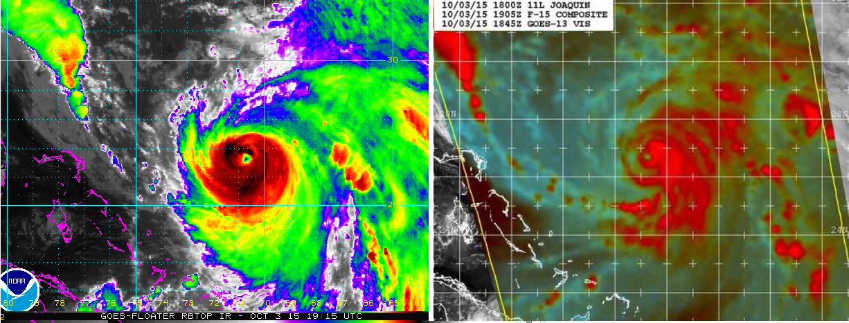
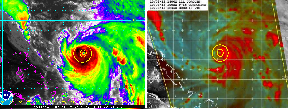
The eye may be shrinking due to another EWR, though it's often hard to tell even with good microwave. On the last 89 ghz pass from SSMI it looks like there may be an outer wall mostly formed around the inner one so it could be that's why the eye is shrinking. I made a comparison from 1900 UTC using RBTOP and MW 89ghz and highlighted where the two walls appear to be. Will be interesting to see what RECON finds.


0 likes

Re: ATL: JOAQUIN - Hurricane - Discussion
The east coast land storm is ingesting the sea storm (Joaquin) ??
Looks like its being sucked in.
http://www.ssd.noaa.gov/goes/east/eaus/flash-vis.html
Looks like its being sucked in.
http://www.ssd.noaa.gov/goes/east/eaus/flash-vis.html
0 likes
Re: ATL: JOAQUIN - Hurricane - Discussion
crimi481 wrote:The east coast land storm is ingesting the sea storm (Joaquin) ??
Looks like its being sucked in.
http://www.ssd.noaa.gov/goes/east/eaus/flash-vis.html
Not really looking like that to me, but more like the storm system over the Southeast U.S. is about to "let go" of Joaquin as the hurricane heads further to the north and east. On the other hand, the low pressure system over the S.E. Conus is ingesting a tremendous amount of moisture from the circulation of Joaquin. There's no doubt that this is severely enhancing the flooding rainfall affecting South Carolina, North Carolina, and adjacent area.
0 likes
Andy D
(For official information, please refer to the NHC and NWS products.)
(For official information, please refer to the NHC and NWS products.)
-
ozonepete
- Professional-Met
- Posts: 4743
- Joined: Mon Sep 07, 2009 3:23 pm
- Location: From Ozone Park, NYC / Now in Brooklyn, NY
Re: ATL: JOAQUIN - Hurricane - Discussion
chaser1 wrote:crimi481 wrote:The east coast land storm is ingesting the sea storm (Joaquin) ??
Looks like its being sucked in.
http://www.ssd.noaa.gov/goes/east/eaus/flash-vis.html
Not really looking like that to me, but more like the storm system over the Southeast U.S. is about to "let go" of Joaquin as the hurricane heads further to the north and east. On the other hand, the low pressure system over the S.E. Conus is ingesting a tremendous amount of moisture from the circulation of Joaquin. There's no doubt that this is severely enhancing the flooding rainfall affecting South Carolina, North Carolina, and adjacent area.
Exactly. Charleston, SC has had a firehose pointed at it since yesterday. They've had almost 9 inches and expect 5 more tonight!
0 likes
Re: ATL: JOAQUIN - Hurricane - Discussion
Has anyone heard any update to the missing container ship out of Jacksonville, Fl. - "El Faro", that was headed to Puerto Rico? Last I heard Coast Guard still has not had any luck locating the ship or survivors thus far.
0 likes
Andy D
(For official information, please refer to the NHC and NWS products.)
(For official information, please refer to the NHC and NWS products.)
-
USTropics
- Professional-Met
- Posts: 2737
- Joined: Sun Aug 12, 2007 3:45 am
- Location: Florida State University
Re: ATL: JOAQUIN - Hurricane - Discussion
No news yet. The Coast Guard has been at it all day though. With the help of the Navy they've employed 5 aircraft - three C-130 planes, an H-60 helicopter and a Navy's P-8 plane were all airborne today. They've covered about 850 square miles with radar but no sign of the ship.
0 likes
-
cycloneye

- Admin
- Posts: 149283
- Age: 69
- Joined: Thu Oct 10, 2002 10:54 am
- Location: San Juan, Puerto Rico
BULLETIN
HURRICANE JOAQUIN INTERMEDIATE ADVISORY NUMBER 25A
NWS NATIONAL HURRICANE CENTER MIAMI FL AL112015
800 PM AST SAT OCT 03 2015
...SEVERE HURRICANE JOAQUIN MOVING NORTHEASTWARD TOWARD BERMUDA...
SUMMARY OF 800 PM AST...0000 UTC...INFORMATION
----------------------------------------------
LOCATION...27.3N 69.6W
ABOUT 455 MI...730 KM SW OF BERMUDA
MAXIMUM SUSTAINED WINDS...145 MPH...235 KM/H
PRESENT MOVEMENT...NE OR 45 DEGREES AT 17 MPH...28 KM/H
MINIMUM CENTRAL PRESSURE...937 MB...27.67 INCHES
0 likes
Visit the Caribbean-Central America Weather Thread where you can find at first post web cams,radars
and observations from Caribbean basin members Click Here
and observations from Caribbean basin members Click Here
-
tolakram
- Admin
- Posts: 20179
- Age: 62
- Joined: Sun Aug 27, 2006 8:23 pm
- Location: Florence, KY (name is Mark)
Re: ATL: JOAQUIN - Hurricane - Discussion
For reports about the Bahamas, including possible deaths, we need links. I can't find any confirmation on this information and I'm worried (hoping actually) it's more rumor than truth. Thanks.
0 likes
M a r k
- - - - -
Join us in chat: Storm2K Chatroom Invite. Android and IOS apps also available.
The posts in this forum are NOT official forecasts and should not be used as such. Posts are NOT endorsed by any professional institution or STORM2K.org. For official information and forecasts, please refer to NHC and NWS products.
- - - - -
Join us in chat: Storm2K Chatroom Invite. Android and IOS apps also available.
The posts in this forum are NOT official forecasts and should not be used as such. Posts are NOT endorsed by any professional institution or STORM2K.org. For official information and forecasts, please refer to NHC and NWS products.
Who is online
Users browsing this forum: No registered users and 227 guests