ENSO Updates (2007 thru 2023)
Moderator: S2k Moderators
Forum rules
The posts in this forum are NOT official forecasts and should not be used as such. They are just the opinion of the poster and may or may not be backed by sound meteorological data. They are NOT endorsed by any professional institution or STORM2K. For official information, please refer to products from the National Hurricane Center and National Weather Service.
Re: ENSO: August PDO data at +1.56
Wow......


0 likes
All posts by Dean_175 are NOT official forecasts and should not be used as such. They are just the opinion of the poster and may or may not be backed by sound meteorological data. They are NOT endorsed by any professional institution or storm2k.org. For official information, please refer to the NHC and NWS products.
Re: ENSO: August PDO data at +1.56
Speechless for it. Especially this late in the year. This with little doubt is one of the great Nino's of our time. Quite likely to balloon once more before weakening.
0 likes
The above post and any post by Ntxw is NOT an official forecast and should not be used as such. It is just the opinion of the poster and may or may not be backed by sound meteorological data. It is NOT endorsed by any professional institution including Storm2k. For official information, please refer to NWS products.
Re: ENSO Updates
0 likes
All posts by Dean_175 are NOT official forecasts and should not be used as such. They are just the opinion of the poster and may or may not be backed by sound meteorological data. They are NOT endorsed by any professional institution or storm2k.org. For official information, please refer to the NHC and NWS products.
Re: ENSO Updates
Dean_175 wrote::uarrow: Do you think we will see the subsurface temp anomalies approaching 6C again in November? CFS doesn't yet show a new massive KW- but if this WWB verifies- what do you think? Each big WWB so far has generated a massive KW with subsurface anomalies reaching 5-6C+ over a fairly large volume.
There's a good chance that will happen. I wasn't certain we would with just the weakened easterlies but with a true WWB now I'd raise the odds of that happening. I think a fairly large area of 5C+ will redevelop or strengthen east of 160W.
0 likes
The above post and any post by Ntxw is NOT an official forecast and should not be used as such. It is just the opinion of the poster and may or may not be backed by sound meteorological data. It is NOT endorsed by any professional institution including Storm2k. For official information, please refer to NWS products.
- Kingarabian
- S2K Supporter

- Posts: 16367
- Joined: Sat Aug 08, 2009 3:06 am
- Location: Honolulu, Hawaii
-
euro6208
Re:
Kingarabian wrote:Excuse the model post but is this all from that huge WWB?
Nope. It develops several typhoons over the WPAC and brings some of those CPAC systems over to the WPAC. Wow, I can't imagine what the ACE will be for the WPAC.
ALready Dujuan impacting Taiwan and Japan.
0 likes
This week's update will remain steady at 2.3C to round out September
0 likes
The above post and any post by Ntxw is NOT an official forecast and should not be used as such. It is just the opinion of the poster and may or may not be backed by sound meteorological data. It is NOT endorsed by any professional institution including Storm2k. For official information, please refer to NWS products.
-
dexterlabio
- Category 5

- Posts: 3510
- Joined: Sat Oct 24, 2009 11:50 pm
Re: Re:
euro6208 wrote:Kingarabian wrote:Excuse the model post but is this all from that huge WWB?
Nope. It develops several typhoons over the WPAC and brings some of those CPAC systems over to the WPAC. Wow, I can't imagine what the ACE will be for the WPAC.
ALready Dujuan impacting Taiwan and Japan.
WPAC is not the only basin in the world, affected by roaring WWB.. All this is a manifestation of El Nino's might. While I didn't expect another round of strong westerlies, I knew this isn't all from this El Nino. If someone says this has peaked, he better rethink that...
0 likes
Personal Forecast Disclaimer:
The posts in this forum are NOT official forecast and should not be used as such. They are just the opinion of the poster and may or may not be backed by sound meteorological data. They are NOT endorsed by any professional institution or storm2k.org. For official information, please refer to the NHC and NWS products.
The posts in this forum are NOT official forecast and should not be used as such. They are just the opinion of the poster and may or may not be backed by sound meteorological data. They are NOT endorsed by any professional institution or storm2k.org. For official information, please refer to the NHC and NWS products.
-
dexterlabio
- Category 5

- Posts: 3510
- Joined: Sat Oct 24, 2009 11:50 pm
My own measurement of El Nino's strength is the drought it will cause to SE Asia. We're gearing for a record-breaking drought here in the Philippines as early as August. Water supply reduction is already implemented to save up water from the reservoirs. I can say that we are quite ready, but seeing the magnitude of this Nino is quite scary especially as we head into 2016. I experienced the '97-98 drought and the absence of rain for a long period was unbearable.
0 likes
Personal Forecast Disclaimer:
The posts in this forum are NOT official forecast and should not be used as such. They are just the opinion of the poster and may or may not be backed by sound meteorological data. They are NOT endorsed by any professional institution or storm2k.org. For official information, please refer to the NHC and NWS products.
The posts in this forum are NOT official forecast and should not be used as such. They are just the opinion of the poster and may or may not be backed by sound meteorological data. They are NOT endorsed by any professional institution or storm2k.org. For official information, please refer to the NHC and NWS products.
- cycloneye
- Admin

- Posts: 149516
- Age: 69
- Joined: Thu Oct 10, 2002 10:54 am
- Location: San Juan, Puerto Rico
Re: ENSO Updates
CPC update of 9/28/15 has Nino 3,4 at +2.3 and that is the same as the past two weeks.
http://www.cpc.ncep.noaa.gov/products/a ... ts-web.pdf
http://www.cpc.ncep.noaa.gov/products/a ... ts-web.pdf
0 likes
Visit the Caribbean-Central America Weather Thread where you can find at first post web cams,radars
and observations from Caribbean basin members Click Here
and observations from Caribbean basin members Click Here
-
Iknownothing
- Tropical Low

- Posts: 13
- Joined: Sun Jul 21, 2013 12:05 pm
Re: ENSO Updates
^^There will be more to talk about in the next week. For one, the September indices will be released in the coming days and we will have a better idea of where this Nino now stands. The ONI for JAS and the monthly ERSSTv4 nino region anomalies will be very important. The OISST weeklies this month have been record high for September, but there is a big difference in the datasets. I think that if we can get at least 1.7-1.8C in the monthly ERSST nino3.4, then there is a chance for an ONI value to reach 2C later this year. Otherwise, we will be stuck with "just" a strong Nino.
We should see a strong WWB in the next few days. This would help push more warm water eastward and help keep the subsurface temps warm. This could help us to see more strengthening, or at least "hold" onto the peak values for a longer period of time (late November maybe?). Even if we simply peak a little later- that would help boost the peak ONI. CFS may be picking up on the effects of this WWB since the most recent ensemble members show a peak that is slightly higher and somewhat later than the mean.
We should see a strong WWB in the next few days. This would help push more warm water eastward and help keep the subsurface temps warm. This could help us to see more strengthening, or at least "hold" onto the peak values for a longer period of time (late November maybe?). Even if we simply peak a little later- that would help boost the peak ONI. CFS may be picking up on the effects of this WWB since the most recent ensemble members show a peak that is slightly higher and somewhat later than the mean.
0 likes
All posts by Dean_175 are NOT official forecasts and should not be used as such. They are just the opinion of the poster and may or may not be backed by sound meteorological data. They are NOT endorsed by any professional institution or storm2k.org. For official information, please refer to the NHC and NWS products.
Re: ENSO Updates
Dean_175 wrote:We should see a strong WWB in the next few days. This would help push more warm water eastward and help keep the subsurface temps warm. This could help us to see more strengthening, or at least "hold" onto the peak values for a longer period of time (late November maybe?). Even if we simply peak a little later- that would help boost the peak ONI. CFS may be picking up on the effects of this WWB since the most recent ensemble members show a peak that is slightly higher and somewhat later than the mean.
I'm interested to see if this latest WWB will indeed not only warm it, but how or if it will prolong the event. I was thinking late Oct early Nov would be maxima but you may be right with resurgence this may extend a little longer.
0 likes
The above post and any post by Ntxw is NOT an official forecast and should not be used as such. It is just the opinion of the poster and may or may not be backed by sound meteorological data. It is NOT endorsed by any professional institution including Storm2k. For official information, please refer to NWS products.
Re: ENSO Updates
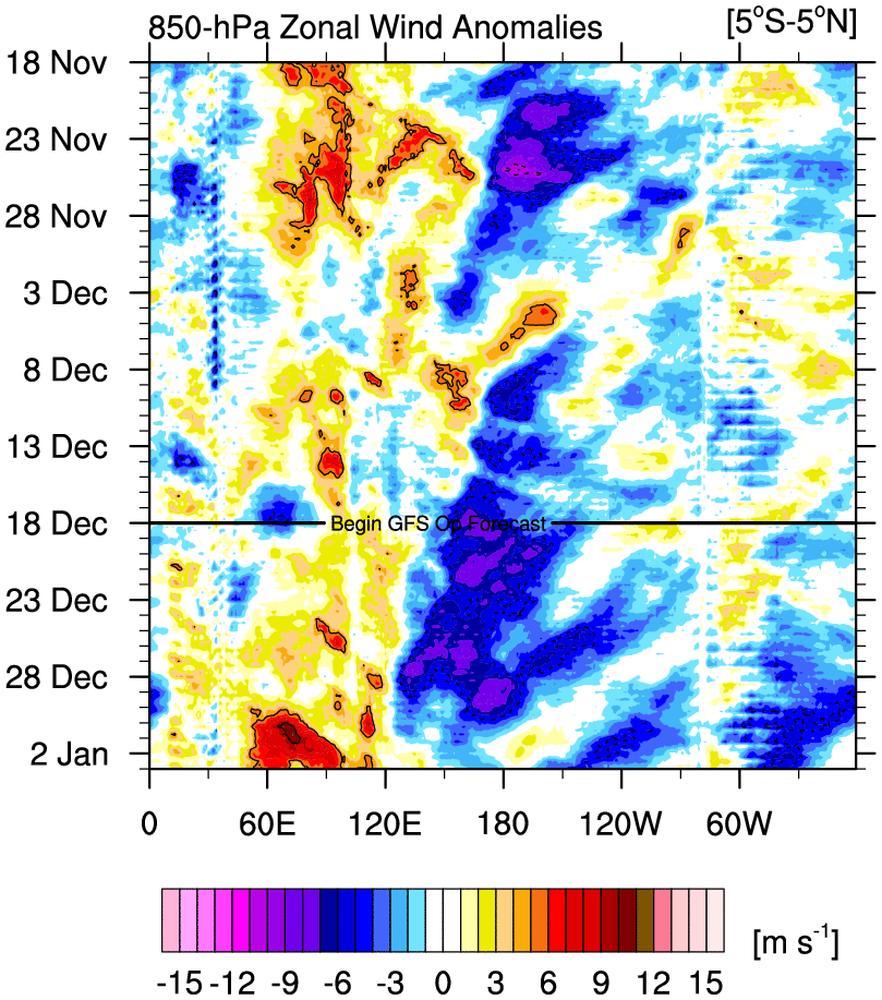
This has been one of the bigger -SOI drops we have seen this year
WWB well underway and even more impressive for the northern hemisphere side

EQ-10N

CFSv2 is sensitive to these Kelvin waves and it sppears to now like December favor as peak. We can definitely see warm water pushing again below the surface east of the dateline now. Curious what the latest ONI will show soon, if it is in the 1.5-1.8 range then odds of a >2 will increase
Code: Select all
SOI values for 03 Oct 2015
Average for last 30 days   -19.93
Average for last 90 days   -16.70
Daily contribution to SOI calculation   -49.77
WWB well underway and even more impressive for the northern hemisphere side

EQ-10N

CFSv2 is sensitive to these Kelvin waves and it sppears to now like December favor as peak. We can definitely see warm water pushing again below the surface east of the dateline now. Curious what the latest ONI will show soon, if it is in the 1.5-1.8 range then odds of a >2 will increase
0 likes
The above post and any post by Ntxw is NOT an official forecast and should not be used as such. It is just the opinion of the poster and may or may not be backed by sound meteorological data. It is NOT endorsed by any professional institution including Storm2k. For official information, please refer to NWS products.
Re: ENSO Updates
The ONI for JAS came in at 1.46C. http://www.cpc.ncep.noaa.gov/data/indices/oni.ascii.txt
The monthly for September isn't posted yet on CPC's page , but the ONI would imply that it is close to 1.7C .
What would you guess is going to be the peak ONI?
0 likes
All posts by Dean_175 are NOT official forecasts and should not be used as such. They are just the opinion of the poster and may or may not be backed by sound meteorological data. They are NOT endorsed by any professional institution or storm2k.org. For official information, please refer to the NHC and NWS products.
- cycloneye
- Admin

- Posts: 149516
- Age: 69
- Joined: Thu Oct 10, 2002 10:54 am
- Location: San Juan, Puerto Rico
Re: ENSO Updates
0 likes
Visit the Caribbean-Central America Weather Thread where you can find at first post web cams,radars
and observations from Caribbean basin members Click Here
and observations from Caribbean basin members Click Here
-
Iknownothing
- Tropical Low

- Posts: 13
- Joined: Sun Jul 21, 2013 12:05 pm
Re: ENSO Updates
Dean_175 wrote::uarrow:
The ONI for JAS came in at 1.46C. http://www.cpc.ncep.noaa.gov/data/indices/oni.ascii.txt
The monthly for September isn't posted yet on CPC's page , but the ONI would imply that it is close to 1.7C .
What would you guess is going to be the peak ONI?
I think we will get over 2C in the end. This latest WWB gives me good confidence it will happen. Given the conservative ONI values I think it will be 2.1 or 2.2C, I was thinking maybe one or two trimonthly but now I believe it may happen in 3 consecutive trimonthlies (>2C).
Monday's update should see 2.4 or 2.5C...just wow. Nino 3 and Nino 1+2 may top 3C
0 likes
The above post and any post by Ntxw is NOT an official forecast and should not be used as such. It is just the opinion of the poster and may or may not be backed by sound meteorological data. It is NOT endorsed by any professional institution including Storm2k. For official information, please refer to NWS products.
- cycloneye
- Admin

- Posts: 149516
- Age: 69
- Joined: Thu Oct 10, 2002 10:54 am
- Location: San Juan, Puerto Rico
Re: CPC 9/5/15 update:Nino 3.4 at +2.4C / ONI up to +1.9C
Big news here as the ONI for July,August and September is up to +1.9C. Super El Nino not out of the cards with this reading.


0 likes
Visit the Caribbean-Central America Weather Thread where you can find at first post web cams,radars
and observations from Caribbean basin members Click Here
and observations from Caribbean basin members Click Here
Actually ONI (ERSSTv4) came in at 1.5C our first official trimonthly in the strong category. My next guess for the next trimonthly will be between 1.6-1.8C. I'm going to call 2.1-2.3C for peak OND or NDJ with the latest OKW helping to prolong it.
Mike Ventrice tweeted the atmospheric index is once again rising above 4 sigma
To note ersstv4 is running lowest of all other datasets, so I'd treat it as the bare minimum requirement. Nearly all other datasets are nearing 2C real time
Mike Ventrice tweeted the atmospheric index is once again rising above 4 sigma
To note ersstv4 is running lowest of all other datasets, so I'd treat it as the bare minimum requirement. Nearly all other datasets are nearing 2C real time
0 likes
The above post and any post by Ntxw is NOT an official forecast and should not be used as such. It is just the opinion of the poster and may or may not be backed by sound meteorological data. It is NOT endorsed by any professional institution including Storm2k. For official information, please refer to NWS products.
Who is online
Users browsing this forum: Ulf, xtyphooncyclonex and 155 guests


