ATL: INVEST 92L - Models
Moderator: S2k Moderators
-
stormlover2013
Re: ATL: INVEST 92L - Models
Throw climo out this is a totally different pattern this year something we don't see to often heck nothing might not even form but all this climo talk lol
Last edited by stormlover2013 on Fri Oct 16, 2015 4:06 pm, edited 2 times in total.
0 likes
-
stormlover2013
Re: ATL: INVEST 92L - Models
If high pressure is strong in se us it can't go to Far East with a cold front approaching and trough going to suck it up
0 likes


Re: ATL: INVEST 92L - Models
the GFDL and HWRF have yet to run this invest. interesting to see if anything comes of this as far as development. Still plenty warm in the GOM.
http://wxmaps.org/pix/hurpot.html#ATL
http://wxmaps.org/pix/hurpot.html#ATL
0 likes

Re: ATL: INVEST 92L - Models
GFS keeps the system over land for all but 12 hours as it passes from Brownsville to Corpus. I'd say overall less than 10% chance of anything but rain coming of it.
0 likes
The above post is not official and should not be used as such. It is the opinion of the poster and may or may not be backed by sound meteorological data. It is not endorsed by any professional institution or storm2k.org. For official information, please refer to the NHC and NWS products.
-
tolakram
- Admin

- Posts: 20178
- Age: 62
- Joined: Sun Aug 27, 2006 8:23 pm
- Location: Florence, KY (name is Mark)
Re: ATL: INVEST 92L - Models
Hammy wrote:GFS keeps the system over land for all but 12 hours as it passes from Brownsville to Corpus. I'd say overall less than 10% chance of anything but rain coming of it.
I honestly have no idea, but with Joaquin the GFS went west, the euro went west, then the euro corrected back east and it took a while for the GFS to follow. The GFS has been pretty bad at either slamming things into the coast or showing systems over land when in fact they end up well east of the forecast. I suspect euro will swing back east, but I have to wonder if anything will really come of this.
0 likes
M a r k
- - - - -
Join us in chat: Storm2K Chatroom Invite. Android and IOS apps also available.
The posts in this forum are NOT official forecasts and should not be used as such. Posts are NOT endorsed by any professional institution or STORM2K.org. For official information and forecasts, please refer to NHC and NWS products.
Re: ATL: INVEST 92L - Models
tolakram wrote:Hammy wrote:GFS keeps the system over land for all but 12 hours as it passes from Brownsville to Corpus. I'd say overall less than 10% chance of anything but rain coming of it.
I honestly have no idea, but with Joaquin the GFS went west, the euro went west, then the euro corrected back east and it took a while for the GFS to follow. The GFS has been pretty bad at either slamming things into the coast or showing systems over land when in fact they end up well east of the forecast. I suspect euro will swing back east, but I have to wonder if anything will really come of this.
If anything I see the Joaquin comparison to mean a more westward track in this case--GFS (as well as early Euro) had it going into the NE because it over-estimated the intensity of the low pressure to the west (as well as the distance between the two). I think that is the same case where both models are assuming pressures will be lower, but in this case it'll mean it's pushed into land rather than escaping a cutoff low.
0 likes
The above post is not official and should not be used as such. It is the opinion of the poster and may or may not be backed by sound meteorological data. It is not endorsed by any professional institution or storm2k.org. For official information, please refer to the NHC and NWS products.

Re: ATL: INVEST 92L - Models
It's 8-9 days out on track. Enjoy you're weekend and check back Monday, lol. If you're playing the odds this far out, look for gradual adjustments to the east.
0 likes
Latest GFS barely develops anything as it keeps the low pretty much over land, and it gets strung out by a frontal system after that.
0 likes
The above post is not official and should not be used as such. It is the opinion of the poster and may or may not be backed by sound meteorological data. It is not endorsed by any professional institution or storm2k.org. For official information, please refer to the NHC and NWS products.
Re: ATL: INVEST 92L - Models
OMG, the 0Z GFS brings the low back down to the NW Caribbean and then on the 2nd go round it takes the classic path NE from there and just misses S FL way out on 10/31 with a H!! Might this be farm betting potential?
0 likes
Personal Forecast Disclaimer:
The posts in this forum are NOT official forecasts and should not be used as such. They are just the opinion of the poster and may or may not be backed by sound meteorological data. They are NOT endorsed by any professional institution or storm2k.org. For official information, please refer to the NHC and NWS products.
The posts in this forum are NOT official forecasts and should not be used as such. They are just the opinion of the poster and may or may not be backed by sound meteorological data. They are NOT endorsed by any professional institution or storm2k.org. For official information, please refer to the NHC and NWS products.
Re: ATL: INVEST 92L - Models
LarryWx wrote:OMG, the 0Z GFS brings the low back down to the NW Caribbean and then on the 2nd go round it takes the classic path NE from there and just misses S FL way out on 10/31 with a H!! Might this be farm betting potential?
GFS is determined at any cost to throw a storm of some kind at Florida/Cuba in October.
0 likes
The above post is not official and should not be used as such. It is the opinion of the poster and may or may not be backed by sound meteorological data. It is not endorsed by any professional institution or storm2k.org. For official information, please refer to the NHC and NWS products.


Re: Re:
Sambucol wrote:TheStormExpert wrote::uarrow: Yep, Euro 216 hrs.
I'll be surprised if that happens!! Rain is fine. But not an organized storm!

Agreed - rain is fine, but nothing organized. We have to remember that the shear is expected to be quite strong, so it may get ripped apart if it does form. Any word on the expected shear?
0 likes
Not a professional forecast by any means.
Audrey'57, Hilda'64, Betsy '65, Edith'71, Carmen'74, Danny'85, Juan'85, Andrew'92, Iniki'92 (while on vacation in Kauai), Lili'02, Rita'05, Humberto'07, Gustav'08, Ike'08, Isaac'12, Monsoonal Depression'16, Harvey'17, Barry'19, Laura'20, Delta'20, Ida'21.
Audrey'57, Hilda'64, Betsy '65, Edith'71, Carmen'74, Danny'85, Juan'85, Andrew'92, Iniki'92 (while on vacation in Kauai), Lili'02, Rita'05, Humberto'07, Gustav'08, Ike'08, Isaac'12, Monsoonal Depression'16, Harvey'17, Barry'19, Laura'20, Delta'20, Ida'21.
-
stormlover2013
Re: ATL: INVEST 92L - Models
I just don't see anything developing been getting prolonged on each run...
0 likes
Re: ATL: INVEST 92L - Models
stormlover2013 wrote:I just don't see anything developing been getting prolonged on each run...
I don't either stormlover, but let's hope that we get some moisture out of whatever may be there.

0 likes
Not a professional forecast by any means.
Audrey'57, Hilda'64, Betsy '65, Edith'71, Carmen'74, Danny'85, Juan'85, Andrew'92, Iniki'92 (while on vacation in Kauai), Lili'02, Rita'05, Humberto'07, Gustav'08, Ike'08, Isaac'12, Monsoonal Depression'16, Harvey'17, Barry'19, Laura'20, Delta'20, Ida'21.
Audrey'57, Hilda'64, Betsy '65, Edith'71, Carmen'74, Danny'85, Juan'85, Andrew'92, Iniki'92 (while on vacation in Kauai), Lili'02, Rita'05, Humberto'07, Gustav'08, Ike'08, Isaac'12, Monsoonal Depression'16, Harvey'17, Barry'19, Laura'20, Delta'20, Ida'21.
-
stormlover2013
Re: ATL: INVEST 92L - Models
I hope we can atleast get some rain but heck who knows been a weird pattern just year
0 likes
Euro run begins in about a half hour, I'm expecting a decent westward (and weaker) shift with that run since development is trending more into the Pacific only.
0 likes
The above post is not official and should not be used as such. It is the opinion of the poster and may or may not be backed by sound meteorological data. It is not endorsed by any professional institution or storm2k.org. For official information, please refer to the NHC and NWS products.
Re:
Hammy wrote:Euro run begins in about a half hour, I'm expecting a decent westward (and weaker) shift with that run since development is trending more into the Pacific only.
The 0Z CMC has a 2nd NW Carib low day 10 in position to maybe give a run at FL. Time to pop popcorn for the King though I'm tempted to take a catnap instead.
0 likes
Personal Forecast Disclaimer:
The posts in this forum are NOT official forecasts and should not be used as such. They are just the opinion of the poster and may or may not be backed by sound meteorological data. They are NOT endorsed by any professional institution or storm2k.org. For official information, please refer to the NHC and NWS products.
The posts in this forum are NOT official forecasts and should not be used as such. They are just the opinion of the poster and may or may not be backed by sound meteorological data. They are NOT endorsed by any professional institution or storm2k.org. For official information, please refer to the NHC and NWS products.
-
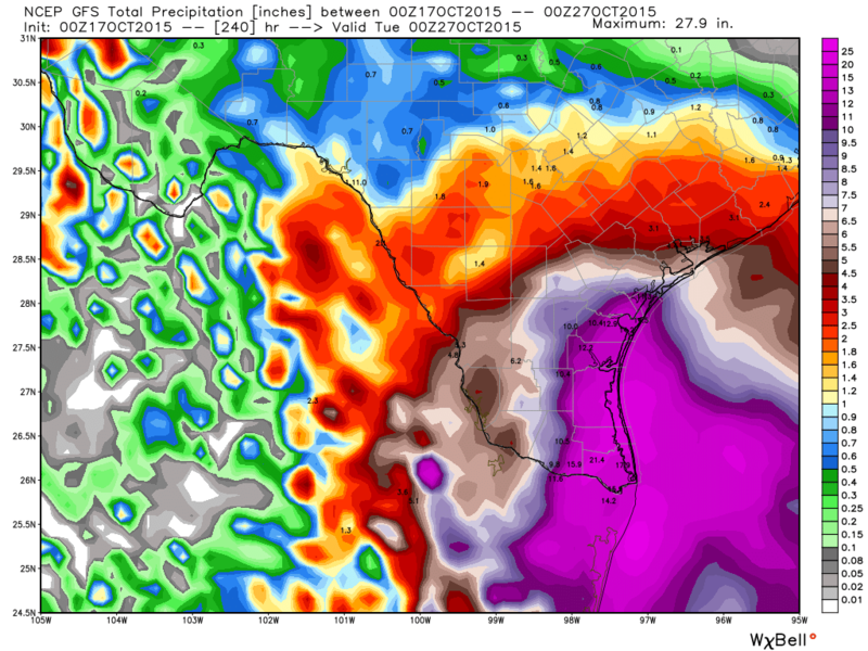
Rgv20

- S2K Supporter

- Posts: 2466
- Age: 39
- Joined: Wed Jan 05, 2011 5:42 pm
- Location: Edinburg/McAllen Tx
0zGFS has some crazy rainfall totals thru day 10 for South Texas! 

0 likes
The following post is NOT an official forecast and should not be used as such. It is just the opinion of the poster and may or may not be backed by sound meteorological data. It is NOT endorsed by any professional institution including storm2k.org For Official Information please refer to the NHC and NWS products.
The 0Z GEFS has a lot of members with a NW C low very late in the run!
The 0Z EC sure has a much weaker EPAC low. Will that affect rest of run?
The 0Z EC sure has a much weaker EPAC low. Will that affect rest of run?
0 likes
Personal Forecast Disclaimer:
The posts in this forum are NOT official forecasts and should not be used as such. They are just the opinion of the poster and may or may not be backed by sound meteorological data. They are NOT endorsed by any professional institution or storm2k.org. For official information, please refer to the NHC and NWS products.
The posts in this forum are NOT official forecasts and should not be used as such. They are just the opinion of the poster and may or may not be backed by sound meteorological data. They are NOT endorsed by any professional institution or storm2k.org. For official information, please refer to the NHC and NWS products.
-
Kingarabian

- S2K Supporter
- Posts: 16348
- Joined: Sat Aug 08, 2009 3:06 am
- Location: Honolulu, Hawaii
Who is online
Users browsing this forum: No registered users and 30 guests