
ATL: INVEST 92L - Discussion
Moderator: S2k Moderators
This was about the earliest time the models from a week ago as well as those endless NAVGEM runs started forming this into a TC back when land interaction wasn't a factor since it was located on the models a little E of its actual location in the open WC. One can see how crucial a small distance trackwise has been.
edit: Luis, ooops, please delete mine. Thanks.
edit: Luis, ooops, please delete mine. Thanks.
0 likes
Personal Forecast Disclaimer:
The posts in this forum are NOT official forecasts and should not be used as such. They are just the opinion of the poster and may or may not be backed by sound meteorological data. They are NOT endorsed by any professional institution or storm2k.org. For official information, please refer to the NHC and NWS products.
The posts in this forum are NOT official forecasts and should not be used as such. They are just the opinion of the poster and may or may not be backed by sound meteorological data. They are NOT endorsed by any professional institution or storm2k.org. For official information, please refer to the NHC and NWS products.
-
Weatherwatcher98
- Category 1

- Posts: 346
- Joined: Sat Sep 12, 2015 10:53 am
Re:
Agreed.LarryWx wrote:This was about the earliest time the models from a week ago as well as those endless NAVGEM runs started forming this into a TC back when land interaction wasn't a factor since it was located on the models a little E of its actual location in the open WC. One can see how crucial a small distance trackwise has been.
edit: Luis, ooops, please delete mine. Thanks.
0 likes
Personal Forecast Disclaimer:
The posts in this forum are NOT official forecast and should not be used as such. They are just the opinion of the poster and may or may not be backed by sound meteorological data. They are NOT endorsed by any professional institution or storm2k.org. For official information, please refer to the NHC and NWS products.
The posts in this forum are NOT official forecast and should not be used as such. They are just the opinion of the poster and may or may not be backed by sound meteorological data. They are NOT endorsed by any professional institution or storm2k.org. For official information, please refer to the NHC and NWS products.
-
northjaxpro

- S2K Supporter

- Posts: 8900
- Joined: Mon Sep 27, 2010 11:21 am
- Location: Jacksonville, FL
92L is looking robust this morning. We'll see if the system can emerge into the Bay of Campeche by late tomorrow/early Monday. I am thinking about only a 20-30% chance of this scenario happening currently.
Strong High pressure will build down into the Mid Atlantic, and it is possible 92L and all that vorticity could stay over Central America or Mexico and get buried down in that region. Also, the ridge is very strong right now, (1033 mb modified Polar High centered over Northern IL at 12Z this morning), 92L will move west/southwest into the Eastern Pacific. I am thinking this is the more likely scenario for the time being.
Strong High pressure will build down into the Mid Atlantic, and it is possible 92L and all that vorticity could stay over Central America or Mexico and get buried down in that region. Also, the ridge is very strong right now, (1033 mb modified Polar High centered over Northern IL at 12Z this morning), 92L will move west/southwest into the Eastern Pacific. I am thinking this is the more likely scenario for the time being.
0 likes
NEVER, EVER SAY NEVER in the tropics and weather in general, and most importantly, with life itself!!
________________________________________________________________________________________
Fay 2008 Beryl 2012 Debby 2012 Colin 2016 Hermine 2016 Julia 2016 Matthew 2016 Irma 2017 Dorian 2019
________________________________________________________________________________________
Fay 2008 Beryl 2012 Debby 2012 Colin 2016 Hermine 2016 Julia 2016 Matthew 2016 Irma 2017 Dorian 2019
-
wxman57

- Moderator-Pro Met

- Posts: 23165
- Age: 68
- Joined: Sat Jun 21, 2003 8:06 pm
- Location: Houston, TX (southwest)
Re: ATL: INVEST 92L - Discussion
The GFS & EC are beginning to come to an agreement on a weak low tracking northward inland over Mexico and into Texas late next week. Lots of cool, dry air is flowing southward across the Gulf now. There's a tremendous amount of shear across the Gulf and BoC. This may provide some well-needed rain for Texas, but it may not be much of a tropical threat.
0 likes

Re: ATL: INVEST 92L - Discussion
Nice vorticity & broad closed surface circulation that 92L has developed inland over the southern Yucatan P during the day today but moderate southerly shear is pushing the convection northward.
EPAC system, soon to be invest, should take over over the next few days and even if 92L goes into the BOC it will have a tough time developing because of shear and outflow from the EPAC system.
EPAC system, soon to be invest, should take over over the next few days and even if 92L goes into the BOC it will have a tough time developing because of shear and outflow from the EPAC system.
0 likes

-
South Texas Storms

- Professional-Met

- Posts: 4252
- Joined: Thu Jun 24, 2010 12:28 am
- Location: Houston, TX
Re:
boca wrote:Is the GFS 12z running late it's 12:30?
Yeah there's been about a 30-45 min delay with the 12z run according to NCEP's model status website. It's up to hour 30 now.
0 likes
-
Weatherwatcher98
- Category 1
- Posts: 346
- Joined: Sat Sep 12, 2015 10:53 am
Re: ATL: INVEST 92L - Discussion
Pretty sure the EPAC system is the one the models are showing crossing over and developing, according to some discussions I have read.NDG wrote:Nice vorticity & broad closed surface circulation that 92L has developed inland over the southern Yucatan P during the day today but moderate southerly shear is pushing the convection northward.
EPAC system, soon to be invest, should take over over the next few days and even if 92L goes into the BOC it will have a tough time developing because of shear and outflow from the EPAC system.
0 likes
Personal Forecast Disclaimer:
The posts in this forum are NOT official forecast and should not be used as such. They are just the opinion of the poster and may or may not be backed by sound meteorological data. They are NOT endorsed by any professional institution or storm2k.org. For official information, please refer to the NHC and NWS products.
The posts in this forum are NOT official forecast and should not be used as such. They are just the opinion of the poster and may or may not be backed by sound meteorological data. They are NOT endorsed by any professional institution or storm2k.org. For official information, please refer to the NHC and NWS products.
-
Weatherwatcher98
- Category 1
- Posts: 346
- Joined: Sat Sep 12, 2015 10:53 am
Re:
GFS Running Now.boca wrote:Is the GFS 12z running late it's 12:30?
0 likes
Personal Forecast Disclaimer:
The posts in this forum are NOT official forecast and should not be used as such. They are just the opinion of the poster and may or may not be backed by sound meteorological data. They are NOT endorsed by any professional institution or storm2k.org. For official information, please refer to the NHC and NWS products.
The posts in this forum are NOT official forecast and should not be used as such. They are just the opinion of the poster and may or may not be backed by sound meteorological data. They are NOT endorsed by any professional institution or storm2k.org. For official information, please refer to the NHC and NWS products.
-
floridasun78
- Category 5

- Posts: 3755
- Joined: Sun May 17, 2009 10:16 pm
- Location: miami fl
Re: ATL: INVEST 92L - Discussion
look more storm forming east of Yucatan over nw Caribbean by caymen islands ( was their poster from cayman island on here for few years?) other thing look new spin maybe starting east of belize
other thing look new spin maybe starting east of belize
Last edited by floridasun78 on Sat Oct 17, 2015 12:04 pm, edited 2 times in total.
0 likes
-
srainhoutx

- S2K Supporter
- Posts: 6919
- Age: 68
- Joined: Sun Jan 14, 2007 11:34 am
- Location: Haywood County, NC
- Contact:
Re: ATL: INVEST 92L - Discussion
The broad surface low is already well West of Cozumel over the Yucatan.
Edit to add: RECON has tentatively been tasked to fly to the Bay of Campeche if the system organizes.
Edit to add: RECON has tentatively been tasked to fly to the Bay of Campeche if the system organizes.
Code: Select all
WEATHER RECONNAISSANCE FLIGHTS
CARCAH, NATIONAL HURRICANE CENTER, MIAMI, FL.
1250 PM EDT SAT 17 OCTOBER 2015
SUBJECT: TROPICAL CYCLONE PLAN OF THE DAY (TCPOD)
         VALID 18/1100Z TO 19/1100Z OCTOBER 2015
         TCPOD NUMBER.....15-144

I.  ATLANTIC REQUIREMENTS
    1. SUSPECT AREA (BAY OF CAMPECHE)
       FLIGHT ONE -- TEAL 71
       A. 18/1900Z
       B. AFXXX 01FFA INVEST
       C. 18/1615Z
       D. 19.5N 93.0W
       E. 18/1830Z TO 18/2230Z
       F. SFC TO 10,000 FT

    2. OUTLOOK FOR SUCCEEDING DAY.....NEGATIVE.
0 likes
Carla/Alicia/Jerry(In The Eye)/Michelle/Charley/Ivan/Dennis/Katrina/Rita/Wilma/Ike/Harvey
Member: National Weather Association
Wx Infinity Forums
http://wxinfinity.com/index.php
Facebook.com/WeatherInfinity
Twitter @WeatherInfinity
Member: National Weather Association
Wx Infinity Forums
http://wxinfinity.com/index.php
Facebook.com/WeatherInfinity
Twitter @WeatherInfinity
-
cycloneye

- Admin

- Posts: 148833
- Age: 69
- Joined: Thu Oct 10, 2002 10:54 am
- Location: San Juan, Puerto Rico
Re: ATL: INVEST 92L - Discussion
TROPICAL WEATHER OUTLOOK
NWS NATIONAL HURRICANE CENTER MIAMI FL
200 PM EDT SAT OCT 17 2015
For the North Atlantic...Caribbean Sea and the Gulf of Mexico:
An area of low pressure located inland about 60 miles west-southwest
of Chetumal, Mexico, is producing shower and thunderstorm activity
across portions of the northwestern Caribbean Sea and the Yucatan
Peninsula. While the circulation of the low has become a little
better defined today, significant development is not expected
through tonight while the low moves slowly west-northwestward across
the southern Yucatan peninsula. However, some development is
possible on Sunday or Monday if the low emerges into the southern
Bay of Campeche. An Air Force Reserve Hurricane Hunter aircraft is
scheduled to investigate this system Sunday afternoon, if necessary.
Regardless of tropical cyclone formation, this system will likely
produce heavy rainfall across portions of Belize, northern
Guatemala, the Yucatan Peninsula, and southeastern Mexico through
Monday.
* Formation chance through 48 hours...low...20 percent
* Formation chance through 5 days...low...20 percent
$$
Forecaster Brennan
0 likes
Visit the Caribbean-Central America Weather Thread where you can find at first post web cams,radars
and observations from Caribbean basin members Click Here
and observations from Caribbean basin members Click Here
Re: ATL: INVEST 92L - Discussion
See if EPAC grabs the energy from it because it is over land.
0 likes
-
cycloneye
- Admin
- Posts: 148833
- Age: 69
- Joined: Thu Oct 10, 2002 10:54 am
- Location: San Juan, Puerto Rico
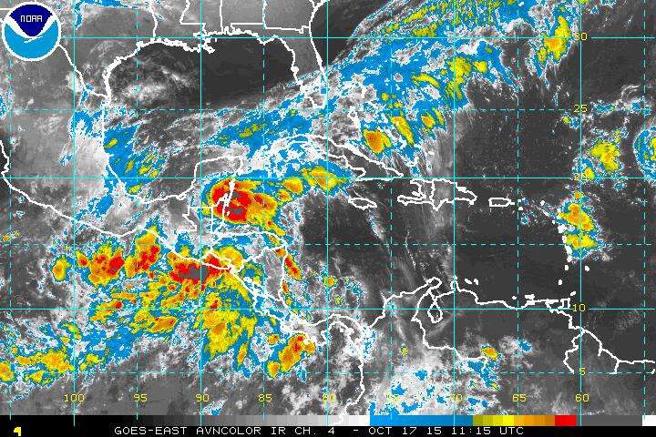
Re: ATL: INVEST 92L - Discussion
There is the Low Pressure as of 18z.

0 likes
Visit the Caribbean-Central America Weather Thread where you can find at first post web cams,radars
and observations from Caribbean basin members Click Here
and observations from Caribbean basin members Click Here
-
Weatherwatcher98
- Category 1
- Posts: 346
- Joined: Sat Sep 12, 2015 10:53 am
Re: ATL: INVEST 92L - Discussion
I see a spin 17-86. Not sure if it's upper level.floridasun78 wrote:look more storm forming east of Yucatan over nw Caribbean by caymen islands ( was their poster from cayman island on here for few years?)
0 likes
Personal Forecast Disclaimer:
The posts in this forum are NOT official forecast and should not be used as such. They are just the opinion of the poster and may or may not be backed by sound meteorological data. They are NOT endorsed by any professional institution or storm2k.org. For official information, please refer to the NHC and NWS products.
The posts in this forum are NOT official forecast and should not be used as such. They are just the opinion of the poster and may or may not be backed by sound meteorological data. They are NOT endorsed by any professional institution or storm2k.org. For official information, please refer to the NHC and NWS products.
-
Weatherwatcher98
- Category 1
- Posts: 346
- Joined: Sat Sep 12, 2015 10:53 am
Re: ATL: INVEST 92L - Discussion

Shear seems to be deceasing a tad.
0 likes
Personal Forecast Disclaimer:
The posts in this forum are NOT official forecast and should not be used as such. They are just the opinion of the poster and may or may not be backed by sound meteorological data. They are NOT endorsed by any professional institution or storm2k.org. For official information, please refer to the NHC and NWS products.
The posts in this forum are NOT official forecast and should not be used as such. They are just the opinion of the poster and may or may not be backed by sound meteorological data. They are NOT endorsed by any professional institution or storm2k.org. For official information, please refer to the NHC and NWS products.
Who is online
Users browsing this forum: No registered users and 72 guests