EPAC: PATRICIA - Post-Tropical
Moderator: S2k Moderators
-
Kingarabian

- S2K Supporter

- Posts: 16381
- Joined: Sat Aug 08, 2009 3:06 am
- Location: Honolulu, Hawaii
-
mrbagyo

- Category 5

- Posts: 3998
- Age: 33
- Joined: Thu Apr 12, 2012 9:18 am
- Location: 14.13N 120.98E
- Contact:
Re: EPAC: PATRICIA - Hurricane: History is made
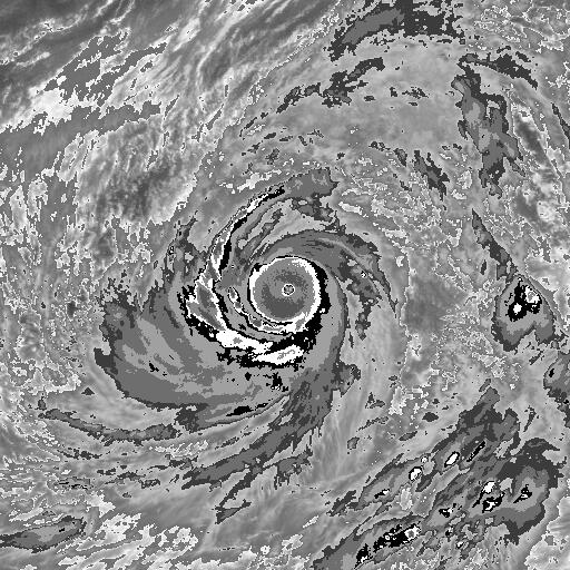
supercane4867 wrote:That wind report at landfall is extremely impressive, comparable to some highest sustained wind ever observed on land.
yep, extremely impressive but I sincerely think those kind of sustained wind have already occured several times in the very remote northeastern coastal region of Luzon island, it's just frustrating that that region has literally NO instruments installed there to verify such reading... Cyclone Olivia's record gust is relatively safe even if that 211 mph gust verfies.
Sanibel wrote:Geesh I can't imagine what some of those poorly-built Mexican dwellings are like now. That is a weak side reading at that location unless it wobbled really far left. That station had 162mph sustained. You can imagine what the business quadrant delivered by the coast.
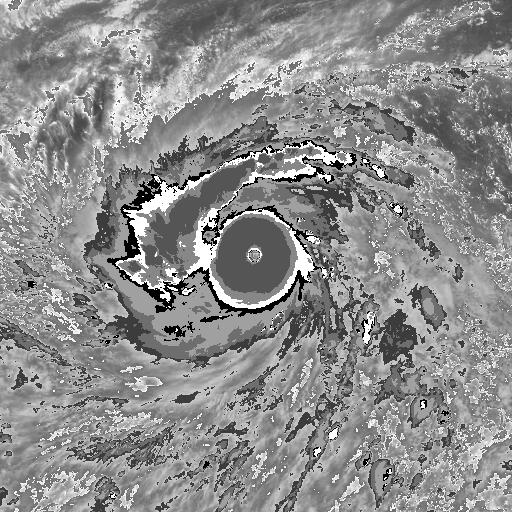
Google Guiuan, Samar images and you will have an idea... this storm is just terrible...
0 likes
The posts in this forum are NOT official forecast and should not be used as such. They are just the opinion of the poster and may or may not be backed by sound meteorological data. They are NOT endorsed by any professional institution or storm2k.org. For official information, please refer to RSMC, NHC and NWS products.
-
brunota2003

- S2K Supporter
- Posts: 9476
- Age: 35
- Joined: Sat Jul 30, 2005 9:56 pm
- Location: Stanton, KY...formerly Havelock, NC
- Contact:
Re: EPAC: PATRICIA - Hurricane: History is made
ozonepete wrote:Has there been any contact with Josh?
Not that I know of. I don't expect to hear anything from him for a couple more days, at least...especially given the place he hunkered down at was only 2.8 miles from the official NHC landfall location.
0 likes
Just a small town southern boy helping other humans.
-
ConAntares
- Tropical Wave

- Posts: 5
- Joined: Sun Oct 05, 2008 12:21 am
Patricia is alarming!
But I still think Typhoon Haiyan is the strongest storm in Pacific Ocean! Which has a horror CDG eye wall and a huge CDO!


But I still think Typhoon Haiyan is the strongest storm in Pacific Ocean! Which has a horror CDG eye wall and a huge CDO!
Last edited by ConAntares on Sat Oct 24, 2015 2:48 am, edited 1 time in total.
0 likes
-
ConAntares
- Tropical Wave
- Posts: 5
- Joined: Sun Oct 05, 2008 12:21 am
-
mrbagyo
- Category 5
- Posts: 3998
- Age: 33
- Joined: Thu Apr 12, 2012 9:18 am
- Location: 14.13N 120.98E
- Contact:
Re: EPAC: PATRICIA - Hurricane: History is made
ConAntares wrote:I think we may have a systematic underestimate on those intense storms which have not been measured!
Such as SP192005Olaf and Typhoon Dianmu(2004), They are very similar to Patricia.
There were lots of them, no need to mention all... but yeah, they 're quite numerous...
Not having recon in other basin aside from NHC AOR is a big loss of data.
0 likes
The posts in this forum are NOT official forecast and should not be used as such. They are just the opinion of the poster and may or may not be backed by sound meteorological data. They are NOT endorsed by any professional institution or storm2k.org. For official information, please refer to RSMC, NHC and NWS products.
-
brunota2003
- S2K Supporter
- Posts: 9476
- Age: 35
- Joined: Sat Jul 30, 2005 9:56 pm
- Location: Stanton, KY...formerly Havelock, NC
- Contact:
Found this, from one of the guys on the NOAA bird during the afternoon flight:
"We were thumped really hard today making our first penetration in Patrica. +3G and -1.5G. The last ten seconds of this video we hit a up draft followed immediately by a down draft. A very sporting day! Airspeed swings from 240 to 170 knots while attempting unsuccessfully to maintain 210 knots. This most definitely is the most powerful storm ever in the western hemisphere. We were thumped so hard that our flight directors keyboard flew off his station and all of his data was dumped. We circled for a hour afterwards as he reconstructed the penetration, made more difficult by the fact the we encountered record setting pressures and airspeeds. This is such a cool job! Thank you Jesus!! B|"
"We were thumped really hard today making our first penetration in Patrica. +3G and -1.5G. The last ten seconds of this video we hit a up draft followed immediately by a down draft. A very sporting day! Airspeed swings from 240 to 170 knots while attempting unsuccessfully to maintain 210 knots. This most definitely is the most powerful storm ever in the western hemisphere. We were thumped so hard that our flight directors keyboard flew off his station and all of his data was dumped. We circled for a hour afterwards as he reconstructed the penetration, made more difficult by the fact the we encountered record setting pressures and airspeeds. This is such a cool job! Thank you Jesus!! B|"
0 likes
Just a small town southern boy helping other humans.
-
AdamFirst

- S2K Supporter
- Posts: 2490
- Age: 36
- Joined: Thu Aug 14, 2008 10:54 am
- Location: Port Saint Lucie, FL
Re:
Kingarabian wrote:When does decapitation begin?
Pretty soon I would imagine. Heading towards mountains ranging from 6,000 to 13,000 feet high
0 likes
Dolphins Marlins Canes Golden Panthers HEAT
Andrew 1992 - Irene 1999 - Frances 2004 - Jeanne 2004 - Wilma 2005 - Fay 2008 - Isaac 2012 - Matthew 2016 - Irma 2017 - Dorian 2019 - Ian 2022 - Nicole 2022 - Milton 2024
Andrew 1992 - Irene 1999 - Frances 2004 - Jeanne 2004 - Wilma 2005 - Fay 2008 - Isaac 2012 - Matthew 2016 - Irma 2017 - Dorian 2019 - Ian 2022 - Nicole 2022 - Milton 2024
-
bamajammer4eva
- Category 4

- Posts: 907
- Joined: Sun Apr 18, 2010 3:21 am
- Location: Ozark, AL
Re: EPAC: PATRICIA - Hurricane: History is made
When people say this was the strongest Hurricane ever they are right. However wasn't Typhoon Tip stronger?
0 likes

Re: EPAC: PATRICIA - Hurricane: History is made
Do we have some kind of long-term track of the remains of the system when it's leaving Mexico, will it enter the Gulf or go more North over land?
0 likes
Personal Forecast Disclaimer:
The posts in this forum are NOT official forecast and should not be used as such. They are just the opinion of the poster and may or may not be backed by sound meteorological data. They are NOT endorsed by any professional institution or storm2k.org. For official information, please refer to the NHC and NWS products.
The posts in this forum are NOT official forecast and should not be used as such. They are just the opinion of the poster and may or may not be backed by sound meteorological data. They are NOT endorsed by any professional institution or storm2k.org. For official information, please refer to the NHC and NWS products.
-
supercane4867
- Category 5
- Posts: 4966
- Joined: Wed Nov 14, 2012 10:43 am
Re: EPAC: PATRICIA - Hurricane: History is made
mrbagyo wrote:ConAntares wrote:I think we may have a systematic underestimate on those intense storms which have not been measured!
Such as SP192005Olaf and Typhoon Dianmu(2004), They are very similar to Patricia.
There were lots of them, no need to mention all... but yeah, they 're quite numerous...
Not having recon in other basin aside from NHC AOR is a big loss of data.
Recon is not only costly but also extremely dangerous to fly in storms at such intensity. It's not necessarily worthy for them to risk their lives getting data for super typhoons way out in the middle of ocean and only affect foreign territories...just sayin
0 likes
-
xtyphooncyclonex

- Category 5
- Posts: 3900
- Age: 24
- Joined: Sat Dec 08, 2012 9:07 am
- Location: Cebu City
- Contact:
Re: EPAC: PATRICIA - Hurricane: History is made
bamajammer4eva wrote:When people say this was the strongest Hurricane ever they are right. However wasn't Typhoon Tip stronger?
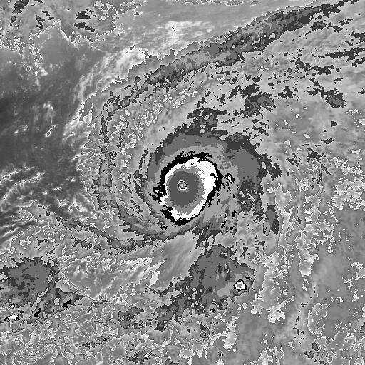
Tip's pressure was 870 mb while this is 9 mb higher. Yet, Patricia's SUSTAINED winds were measured at 175 kts (200 mph; 325 km/h) compared to Tip's 165 kts (190 mph; 305 km/h) so if you're talking winds, Patricia is stronger. Pressure --- Still, Tip's record is undefeated. Also, this is the strongest storm in the Western Hemisphere (also called hurricane) in both aspects. Since recon data in the 50's and 60's is said to be unreliable, then Patricia is the strongest tropical cyclone in the world's recorded history in terms of wind speeds. Haiyan's record nearly 2 years ago was unknown since recon never flew over the storm
0 likes
REMINDER: My opinions that I, or any other NON Pro-Met in this forum, are unofficial. Please do not take my opinions as an official forecast and warning. I am NOT a meteorologist. Following my forecasts blindly may lead to false alarm, danger and risk if official forecasts from agencies are ignored.
-
ConAntares
- Tropical Wave
- Posts: 5
- Joined: Sun Oct 05, 2008 12:21 am
Re: EPAC: PATRICIA - Hurricane: History is made
bamajammer4eva wrote:When people say this was the strongest Hurricane ever they are right. However wasn't Typhoon Tip stronger?
Ty Gay(1992), Ty Haiyan Ty Andy(1989), Ty Yuri(1991), and Haiyan are likely stronger than Tyhoon Tip based on satellite cloud image analysis.
Typhoon Tip(1979)
Typhoon Andy(1989)
Typhoon Yuri(1991)
Typhoon Gay(1992)
Typhoon Haiyan(2013)
0 likes
-
xtyphooncyclonex
- Category 5
- Posts: 3900
- Age: 24
- Joined: Sat Dec 08, 2012 9:07 am
- Location: Cebu City
- Contact:
Re:
ConAntares wrote:Patricia is alarming!
But I still think Typhoon Haiyan is the strongest storm in Pacific Ocean! Which has a horror CDG eye wall and a huge CDO!
Patricia was smaller, yet it's eye was much warmer and it's CDG was also present. Haiyan is stronger than Patricia at landfall, but other than that, I honestly prefer Patricia.


0 likes
REMINDER: My opinions that I, or any other NON Pro-Met in this forum, are unofficial. Please do not take my opinions as an official forecast and warning. I am NOT a meteorologist. Following my forecasts blindly may lead to false alarm, danger and risk if official forecasts from agencies are ignored.
-
WeatherGuesser
- Category 5
- Posts: 2672
- Joined: Tue Jun 29, 2010 6:46 am
Re: EPAC: PATRICIA - Hurricane: History is made
xtyphooncyclonex wrote:bamajammer4eva wrote:When people say this was the strongest Hurricane ever they are right. However wasn't Typhoon Tip stronger?
Tip's pressure was 870 mb while this is 9 mb higher.
There was an 869 posted, but I don't know if it was final or not.
0 likes
-
xtyphooncyclonex
- Category 5
- Posts: 3900
- Age: 24
- Joined: Sat Dec 08, 2012 9:07 am
- Location: Cebu City
- Contact:
Re: EPAC: PATRICIA - Hurricane: History is made
WeatherGuesser wrote:There was an 869 posted, but I don't know if it was final or not.
Perhaps, but the NHC listed 879. This thing may challenge Tip later in post-analysis
0 likes
REMINDER: My opinions that I, or any other NON Pro-Met in this forum, are unofficial. Please do not take my opinions as an official forecast and warning. I am NOT a meteorologist. Following my forecasts blindly may lead to false alarm, danger and risk if official forecasts from agencies are ignored.
-
ConAntares
- Tropical Wave
- Posts: 5
- Joined: Sun Oct 05, 2008 12:21 am
Re: Re:
xtyphooncyclonex wrote:ConAntares wrote:Patricia is alarming!
But I still think Typhoon Haiyan is the strongest storm in Pacific Ocean! Which has a horror CDG eye wall and a huge CDO!
Patricia was smaller, yet it's eye was much warmer and it's CDG was also present. Haiyan is stronger than Patricia at landfall, but other than that, I honestly prefer Patricia.
But Haiyan even owns VCDG surrounding it's eye......
CDG surrounding WMG is not uncommon in the WP.
However there are lots of tyhoons and cyclones have not been measured.
We are most likely to miss these them which are stronger than we thought.
Last edited by ConAntares on Sat Oct 24, 2015 3:27 am, edited 2 times in total.
0 likes
Re: EPAC: PATRICIA - Hurricane: History is made
HURRICANE PATRICIA DISCUSSION NUMBER 18
NWS NATIONAL HURRICANE CENTER MIAMI FL EP202015
400 AM CDT SAT OCT 24 2015
Patricia has been weakening rapidly while moving farther inland over
the rugged terrain of western Mexico. Although the circulation
is still intact, the associated convection has lost a significant
amount of organization. Based on the degraded appearance, the
initial intensity is lowered to 65 kt. Patricia is moving quickly
north-northeastward at about 18 kt embedded in the flow between a
trough over northwestern Mexico and an anticyclone over the Gulf of
Mexico. This motion is expected to continue until Patricia
dissipates over the mountains of Mexico by tonight.
The global models continue to depict the development of a cyclone
near the Texas coast over the weekend and this system should be
non-tropical in nature. However, this system is expected to draw
significant amounts of moisture from Patricia's remnants, and could
result in locally heavy rainfall over portions of the northwestern
Gulf of Mexico coastal area within the next couple of days. Refer
to statements from local National Weather Service forecast offices
for details.
The wind radii in the southeastern quadrant has been expanded
outward significantly based on recent ASCAT passes, which indicated
that tropical-storm-force winds were still occurring in a convective
band near the coast of southwestern Mexico.
KEY MESSAGES:
1. Even though Patricia is weakening quickly, strong and damaging
winds at higher elevations could persist through this morning.
2. Continued very heavy rainfall is likely to cause life-
threatening flash floods and mudslides in the Mexican states of
Nayarit, Jalisco, Colima, Michoacan and Guerrero through today.
FORECAST POSITIONS AND MAX WINDS
INIT 24/0900Z 22.3N 103.1W 65 KT 75 MPH...INLAND
12H 24/1800Z 24.6N 101.2W 40 KT 45 MPH...INLAND
24H 25/0600Z...DISSIPATED
$$
Forecaster Cangialosi/Stewart
0 likes
Re: EPAC: PATRICIA - Hurricane: History is made
HURRICANE PATRICIA ADVISORY NUMBER 18
NWS NATIONAL HURRICANE CENTER MIAMI FL EP202015
400 AM CDT SAT OCT 24 2015
...PATRICIA RAPIDLY WEAKENING OVER MEXICO...
...HEAVY RAINS CONTINUE...
SUMMARY OF 400 AM CDT...0900 UTC...INFORMATION
----------------------------------------------
LOCATION...22.3N 103.1W
ABOUT 50 MI...80 KM...SSW OF ZACATECAS MEXICO
ABOUT 130 MI...205 KM ENE OF TEPIC MEXICO
MAXIMUM SUSTAINED WINDS...75 MPH...120 KM/H
PRESENT MOVEMENT...NNE OR 25 DEGREES AT 21 MPH...33 KM/H
MINIMUM CENTRAL PRESSURE...986 MB...29.12 INCHES
WATCHES AND WARNINGS
--------------------
CHANGES WITH THIS ADVISORY:
The government of Mexico has discontinued the Tropical Storm
Warning west of Manzanillo.
SUMMARY OF WATCHES AND WARNINGS IN EFFECT:
A Tropical Storm Warning is in effect for...
* Manzanillo to Lazaro Cardenas
A Tropical Storm Warning means that tropical storm conditions are
likely occurring within the warning area.
For storm information specific to your area, please monitor
products issued by your national meteorological service.
DISCUSSION AND 48-HOUR OUTLOOK
------------------------------
At 400 AM CDT (0900 UTC), the center of Hurricane Patricia was
located near latitude 22.3 North, longitude 103.1 West. Patricia is
moving toward the north-northeast near 21 mph (33 km/h). Patricia is
forecast to move quickly north-northeastward farther inland over
northern and northeastern Mexico today.
Maximum sustained winds have decreased to near 75 mph (120 km/h)
with higher gusts. Rapid weakening is expected to continue, and
Patricia is forecast to become a tropical storm later this morning,
and dissipate tonight.
Hurricane-force winds extend outward up to 25 miles (35 km) from the
center and tropical-storm-force winds extend outward up to 290 miles
(465 km).
The estimated minimum central pressure is 986 mb (29.12 inches).
HAZARDS AFFECTING LAND
----------------------
WIND: Tropical storm conditions are expected to continue across
portions of the warning area and over inland areas, especially in
higher elevations, near the center through this morning.
RAINFALL: Patricia is expected to produce total rainfall
accumulations of 8 to 12 inches, with isolated maximum amounts of
20 inches, over the Mexican states of Nayarit, Jalisco, Colima,
Michoacan, and Guerrero through Saturday. These rains are likely
to produce life-threatening flash floods and mudslides. During the
past 24 hours, a rainfall total of 10.25 inches (260 mm) has been
reported at Nevado De Colima in Jalisco state.
STORM SURGE: Water levels are expected to gradually subside but
will remain above normal through late today.
NEXT ADVISORY
-------------
Next intermediate advisory at 700 AM CDT.
Next complete advisory at 1000 AM CDT.
$$
Forecaster Cangialosi/Stewart
0 likes
Who is online
Users browsing this forum: No registered users and 37 guests