Honestly I'd vote new page, since if it gets named I'd be pretty certain it would be classified as Kate since the LLC appears to have been pretty much eaten up over Mexico... which would leave the thread covering two storms that while certainly highly related were considered separate entities.
Plus it leaves this thread to be a historical monument to the intensity of Patricia, and a brief Gulf tropical storm thrown on to the end of it would be a little tacky lol.
EPAC: PATRICIA - Post-Tropical
Moderator: S2k Moderators
-
EquusStorm
- Category 5

- Posts: 1649
- Age: 35
- Joined: Thu Nov 07, 2013 1:04 pm
- Location: Jasper, AL
- Contact:

Re: EPAC: PATRICIA - Hurricane: History is made
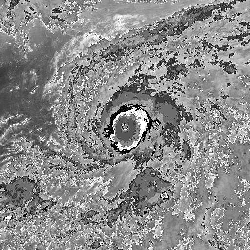
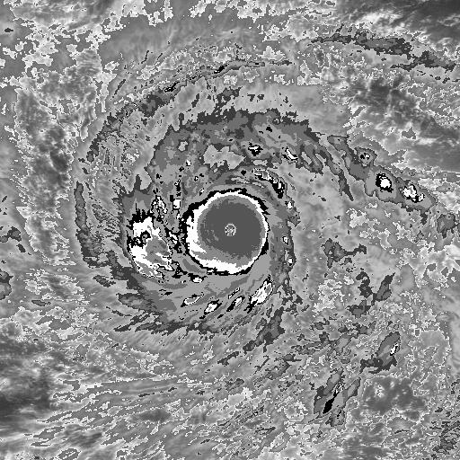
ConAntares wrote:bamajammer4eva wrote:When people say this was the strongest Hurricane ever they are right. However wasn't Typhoon Tip stronger?
Ty Gay(1992), Ty Haiyan Ty Andy(1989), Ty Yuri(1991), and Haiyan are likely stronger than Tyhoon Tip based on satellite cloud image analysis.
Typhoon Tip(1979)
Typhoon Andy(1989)
Typhoon Yuri(1991)
Typhoon Gay(1992)
Typhoon Haiyan(2013)
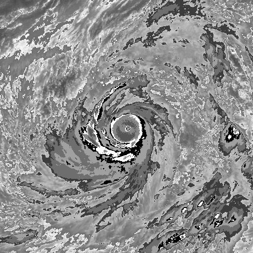
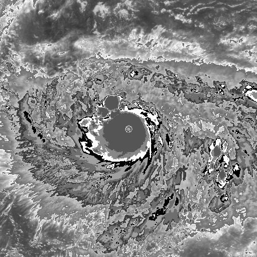
The eye of Super Typhoon Tip is not completely surrounded by extremely cold cloud tops like other super typhoons. Tip at its peak had 870 millibars and 190 mph winds. Tip was actually largest when it weakened from its peak.
0 likes
Re: EPAC: PATRICIA - Post-Tropical
CrazyC83 wrote:Personal Forecast Disclaimer:
The posts in this forum are NOT official forecast and should not be used as such. They are just the opinion of the poster and may or may not be backed by sound meteorological data. They are NOT endorsed by any professional institution or storm2k.org. For official information, please refer to the NHC and NWS products.
This is completely unofficial. However, here is what I would set as the best track for Patricia.
EP202015, PATRICIA, 18,
20151020, 1200, , TD, 13.3N, 94.2W, 30, 1008,
20151020, 1800, , TS, 13.3N, 94.6W, 35, 1006,
20151021, 0000, , TS, 13.1N, 95.1W, 40, 1004,
20151021, 0600, , TS, 12.9N, 96.3W, 40, 1003,
20151021, 1200, , TS, 12.9N, 97.4W, 45, 1001,
20151021, 1800, , TS, 13.1N, 98.7W, 55, 996,
20151022, 0000, , HU, 13.4N, 100.1W, 65, 989,
20151022, 0600, , HU, 14.0N, 101.7W, 80, 980,
20151022, 1200, , HU, 14.7N, 103.2W, 95, 968,
20151022, 1800, , HU, 15.1N, 104.1W, 120, 956,
20151023, 0000, , HU, 15.8N, 104.9W, 150, 921,
20151023, 0600, , HU, 16.5N, 105.4W, 175, 886,
20151023, 1200, , HU, 17.2N, 105.6W, 180, 875,
20151023, 1800, , HU, 18.2N, 105.3W, 170, 879,
20151023, 2100, T, HU, 18.8N, 105.1W, 150, 902,
20151023, 2315, L, HU, 19.4N, 105.0W, 140, 918,
20151024, 0000, , HU, 19.6N, 104.9W, 130, 922,
20151024, 0600, , HU, 21.6N, 103.8W, 85, 970,
20151024, 1200, , TS, 23.2N, 102.3W, 45, 996,
20151024, 1800, , LO, 24.7N, 101.3W, 25, 1005,
Sounds about right. Mexico's most intense hurricane to make landfall is Gilbert in 1988, which had central pressure of 900 millibars and 165 mph winds. Gilbert was much larger than Patricia.
Diameter Of Hurricane Force Wind
Gilbert (Yucatan Landfall)
230 miles
Patricia
50 miles
Best Track 1988-2013
ftp://rammftp.cira.colostate.edu/demari ... k_atlc.txt
0 likes
-
cycloneye

- Admin

- Posts: 149275
- Age: 69
- Joined: Thu Oct 10, 2002 10:54 am
- Location: San Juan, Puerto Rico
There is a thread at Talking Tropics forum for the GOM area. I guess there would be new invest 93L and the name Kate if it develops.This thread will be the Patricia historic one.
viewtopic.php?f=31&t=117667&start=0
viewtopic.php?f=31&t=117667&start=0
0 likes
Visit the Caribbean-Central America Weather Thread where you can find at first post web cams,radars
and observations from Caribbean basin members Click Here
and observations from Caribbean basin members Click Here
-
mrbagyo

- Category 5
- Posts: 3963
- Age: 33
- Joined: Thu Apr 12, 2012 9:18 am
- Location: 14.13N 120.98E
- Contact:
Re: EPAC: PATRICIA - Hurricane: History is made
supercane4867 wrote:Recon is not only costly but also extremely dangerous to fly in storms at such intensity. It's not necessarily worthy for them to risk their lives getting data for super typhoons way out in the middle of ocean and only affect foreign territories...just sayin
That's why I suggested using Global Hawk in my earlier post. I know UAVs aren't perfect but we can certainly improve that technology.
0 likes
The posts in this forum are NOT official forecast and should not be used as such. They are just the opinion of the poster and may or may not be backed by sound meteorological data. They are NOT endorsed by any professional institution or storm2k.org. For official information, please refer to RSMC, NHC and NWS products.
-
euro6208
Re: EPAC: PATRICIA - Post-Tropical
Finally had time to read through this thread after a long week of work.
What's fascinating is how a hurricane from the EPAC which is way less brutal than the WPAC very much acted like a Super Typhoon and being compared to record breaking STY's in the past that were long forgotten in history until Patricia came. Had this occured in the WPAC, it would be considered normal.
This will certainly wake up alot of people about how vital recon is and to improve research about other Super Typhoons in the world's best laboratory lacking recon.
0 likes
-
CrazyC83
- Professional-Met

- Posts: 34315
- Joined: Tue Mar 07, 2006 11:57 pm
- Location: Deep South, for the first time!
Re: EPAC: PATRICIA - Post-Tropical
Ptarmigan wrote:CrazyC83 wrote:Personal Forecast Disclaimer:
The posts in this forum are NOT official forecast and should not be used as such. They are just the opinion of the poster and may or may not be backed by sound meteorological data. They are NOT endorsed by any professional institution or storm2k.org. For official information, please refer to the NHC and NWS products.
This is completely unofficial. However, here is what I would set as the best track for Patricia.
EP202015, PATRICIA, 18,
20151020, 1200, , TD, 13.3N, 94.2W, 30, 1008,
20151020, 1800, , TS, 13.3N, 94.6W, 35, 1006,
20151021, 0000, , TS, 13.1N, 95.1W, 40, 1004,
20151021, 0600, , TS, 12.9N, 96.3W, 40, 1003,
20151021, 1200, , TS, 12.9N, 97.4W, 45, 1001,
20151021, 1800, , TS, 13.1N, 98.7W, 55, 996,
20151022, 0000, , HU, 13.4N, 100.1W, 65, 989,
20151022, 0600, , HU, 14.0N, 101.7W, 80, 980,
20151022, 1200, , HU, 14.7N, 103.2W, 95, 968,
20151022, 1800, , HU, 15.1N, 104.1W, 120, 956,
20151023, 0000, , HU, 15.8N, 104.9W, 150, 921,
20151023, 0600, , HU, 16.5N, 105.4W, 175, 886,
20151023, 1200, , HU, 17.2N, 105.6W, 180, 875,
20151023, 1800, , HU, 18.2N, 105.3W, 170, 879,
20151023, 2100, T, HU, 18.8N, 105.1W, 150, 902,
20151023, 2315, L, HU, 19.4N, 105.0W, 140, 918,
20151024, 0000, , HU, 19.6N, 104.9W, 130, 922,
20151024, 0600, , HU, 21.6N, 103.8W, 85, 970,
20151024, 1200, , TS, 23.2N, 102.3W, 45, 996,
20151024, 1800, , LO, 24.7N, 101.3W, 25, 1005,
Sounds about right. Mexico's most intense hurricane to make landfall is Gilbert in 1988, which had central pressure of 900 millibars and 165 mph winds. Gilbert was much larger than Patricia.
Diameter Of Hurricane Force Wind
Gilbert (Yucatan Landfall)
230 miles
Patricia
50 miles
Best Track 1988-2013
ftp://rammftp.cira.colostate.edu/demari ... k_atlc.txt
I used the Schloemer equation relative to the observations near Chamela (minimum there was 948) to analyze the pressure at landfall. It was actually recorded at 2350Z and matches up to 922 at that time, but given filling post-landfall, I estimated the landfall pressure as 918. Using measurements from iCyclone at 2315Z also seemed to agree with that reading.
0 likes
-
SeGaBob
Re: EPAC: PATRICIA - Post-Tropical
euro6208 wrote:Finally had time to read through this thread after a long week of work.
What's fascinating is how a hurricane from the EPAC which is way less brutal than the WPAC very much acted like a Super Typhoon and being compared to record breaking STY's in the past that were long forgotten in history until Patricia came. Had this occured in the WPAC, it would be considered normal.
This will certainly wake up alot of people about how vital recon is and to improve research about other Super Typhoons in the world's best laboratory lacking recon.
WPAC is not the only basin in the world like you make it out to be, and you can't say they're any less brutal than super typhoons...
1 likes
-
euro6208
Re: EPAC: PATRICIA - Post-Tropical
SeGaBob wrote:euro6208 wrote:Finally had time to read through this thread after a long week of work.
What's fascinating is how a hurricane from the EPAC which is way less brutal than the WPAC very much acted like a Super Typhoon and being compared to record breaking STY's in the past that were long forgotten in history until Patricia came. Had this occured in the WPAC, it would be considered normal.
This will certainly wake up alot of people about how vital recon is and to improve research about other Super Typhoons in the world's best laboratory lacking recon.
WPAC is not the only basin in the world like you make it out to be, and you can't say they're any less brutal than super typhoons...
Well we can all agree that EPAC hurricanes are mostly fishes while WPAC storms mostly hit land. That's what i meant.
0 likes
-
Yellow Evan

- Professional-Met
- Posts: 16231
- Age: 27
- Joined: Fri Jul 15, 2011 12:48 pm
- Location: Henderson, Nevada/Honolulu, HI
- Contact:
Re: EPAC: PATRICIA - Post-Tropical
euro6208 wrote:
Well we can all agree that EPAC hurricanes are mostly fishes while WPAC storms mostly hit land. That's what i meant.
Yes, but the EPAC can still from time to time spawn monsters that are as strong or even stronger than most WPAC super typhoonsw. Honestly, only storm for sure I think was stronger than this was Haiyan.
0 likes
-
Yellow Evan
- Professional-Met
- Posts: 16231
- Age: 27
- Joined: Fri Jul 15, 2011 12:48 pm
- Location: Henderson, Nevada/Honolulu, HI
- Contact:
iCyclone's chase report is out:
http://icyclone.com/chases/patricia-2015.html
I really don't know how strong is was at landfall. If we throw out the wind data from the observation station whose name I forgot, this could have been a Cat 4. The pressure gradient was really steep, but the pressure iCyclone measured (depends on winds, which I asked him about on AmericanWx) would correspond to 930mbar, but other pressure data on land could imply a lower pressure (915-920mbar). A blend between a WPAC and ATL P-W IMO would apply here (small storm but from the monsoon trough), so I'm really not sure, given the pressure uncertainties noted above. I keep going back and forth between Cat 4 and Cat 5. If the 155 knot winds are verified (which I doubt), that'd support 135 knts on the surface there and around 145 knots at landfall.
0 likes
-
cycloneye
- Admin
- Posts: 149275
- Age: 69
- Joined: Thu Oct 10, 2002 10:54 am
- Location: San Juan, Puerto Rico
Re: EPAC: PATRICIA - Post-Tropical
Here is a great video from chaser Josh Morgerman (iCyclone) of Patricia as the core moved thru that area.
https://www.youtube.com/watch?v=V2H1M0n ... e=youtu.be
https://www.youtube.com/watch?v=V2H1M0n ... e=youtu.be
0 likes
Visit the Caribbean-Central America Weather Thread where you can find at first post web cams,radars
and observations from Caribbean basin members Click Here
and observations from Caribbean basin members Click Here
-
northjaxpro

- S2K Supporter

- Posts: 8900
- Joined: Mon Sep 27, 2010 11:21 am
- Location: Jacksonville, FL
What a powerful video showing the utter brute force of historic tropical cyclone Patricia. This video was nothing short of amazing, yet terrifying to watch, especially as the extremely tightly wound inner core of Patricia came ashore. Thanks cycloneye for sharing this link on the thread.
Interesting during the video that the lowest pressure I had heard Morgerman say, if I am not mistaken, measured was at 938 mb before he had to run inside for safety, which lends credence that Patricia at her lowest probably was somewhere in the 920s mb range upon passage at that locale in Emiliano Zapata, Mexico on this video. Patricia significantly weakened at landfall from what she had been at 879 mb (possibly even lower) hours before. The report on the video states Patricia at 145kts at landfall. That is probably about right, though still a bit of room for debate possibly in post -analysis. Regardless, during the time of this video, the cyclone still a strong Cat 4/ min Cat 5, which still is extremely impressive nevertheless. Amazing storm!
Interesting during the video that the lowest pressure I had heard Morgerman say, if I am not mistaken, measured was at 938 mb before he had to run inside for safety, which lends credence that Patricia at her lowest probably was somewhere in the 920s mb range upon passage at that locale in Emiliano Zapata, Mexico on this video. Patricia significantly weakened at landfall from what she had been at 879 mb (possibly even lower) hours before. The report on the video states Patricia at 145kts at landfall. That is probably about right, though still a bit of room for debate possibly in post -analysis. Regardless, during the time of this video, the cyclone still a strong Cat 4/ min Cat 5, which still is extremely impressive nevertheless. Amazing storm!
0 likes
NEVER, EVER SAY NEVER in the tropics and weather in general, and most importantly, with life itself!!
________________________________________________________________________________________
Fay 2008 Beryl 2012 Debby 2012 Colin 2016 Hermine 2016 Julia 2016 Matthew 2016 Irma 2017 Dorian 2019
________________________________________________________________________________________
Fay 2008 Beryl 2012 Debby 2012 Colin 2016 Hermine 2016 Julia 2016 Matthew 2016 Irma 2017 Dorian 2019
-
cycloneye
- Admin
- Posts: 149275
- Age: 69
- Joined: Thu Oct 10, 2002 10:54 am
- Location: San Juan, Puerto Rico
Re: EPAC: PATRICIA - Post-Tropical
Impressive VDM that has to be saved.
VORTEX DATA MESSAGE EP202015
A. 23/17:33:00Z
B. 18 deg 10 min N
105 deg 16 min W
C. NA
D. 145 kt
E. 305 deg / 5 nm
F. 055 deg / 160 kt
G. 315 deg 4 nm
H. 883 mb
I. 12 C / 3063 m
J. 28 C / 2901 m
K. 11 C / NA
L. CLOSED WALL
M. C7
N. 12345 / 7
O. 1 / 1 nm
P. NOAA3 0420E PATRICIA OB 04 CCA
MAX OUTBOUND AND MAX FL WIND 192 KT 125 / 8 NM 17:40:49Z
MAX OUTBOUND SFMR WIND 166 KTS / 135 deg 4 nm
CNTR DROPSONDE SFC WIND 180 / 45 KTS
2 likes
Visit the Caribbean-Central America Weather Thread where you can find at first post web cams,radars
and observations from Caribbean basin members Click Here
and observations from Caribbean basin members Click Here
-
Kingarabian

- S2K Supporter
- Posts: 16348
- Joined: Sat Aug 08, 2009 3:06 am
- Location: Honolulu, Hawaii
-
1900hurricane

- Category 5
- Posts: 6063
- Age: 34
- Joined: Fri Feb 06, 2015 12:04 pm
- Location: Houston, TX
- Contact:
Re: EPAC: PATRICIA - Post-Tropical
The Bulletin of the American Meteorological Society has a new paper on Patricia up.
Re-Writing the Tropical Record Books: The Extraordinary Intensification of Hurricane Patricia (2015)
Re-Writing the Tropical Record Books: The Extraordinary Intensification of Hurricane Patricia (2015)
0 likes
Contract Meteorologist. TAMU & MSST. Fiercely authentic, one of a kind. We are all given free will, so choose a life meant to be lived. We are the Masters of our own Stories.
Opinions expressed are mine alone.
Follow me on Twitter at @1900hurricane : Read blogs at https://1900hurricane.wordpress.com/
Opinions expressed are mine alone.
Follow me on Twitter at @1900hurricane : Read blogs at https://1900hurricane.wordpress.com/
-
cycloneye
- Admin
- Posts: 149275
- Age: 69
- Joined: Thu Oct 10, 2002 10:54 am
- Location: San Juan, Puerto Rico
Re: EPAC: PATRICIA - Post-Tropical
Dvorak at peak was the highest ever at 8.4.
https://twitter.com/AlexJLamers/status/845079136251064321
https://twitter.com/AlexJLamers/status/845079136251064321
0 likes
Visit the Caribbean-Central America Weather Thread where you can find at first post web cams,radars
and observations from Caribbean basin members Click Here
and observations from Caribbean basin members Click Here
-
euro6208
-
1900hurricane
- Category 5
- Posts: 6063
- Age: 34
- Joined: Fri Feb 06, 2015 12:04 pm
- Location: Houston, TX
- Contact:
Re: EPAC: PATRICIA - Strongest storm in the WHem
euro6208 wrote:So 1992's Super Typhoon Gay's 8.7 is discounted?
In this case, yes, since that 8.7 is an unofficial number from an older ODT (the precursor to ADT) used in Hoarau's paper from thirteen years ago. Patricia's 8.4 is based on a tweaked ADT 8.2.1 (the one used right now) from the Velden study, which was also discussed on page 6 of the Discussion of Intense Tropical Cyclones thread. Typhoons Tip '79, Gay '92, and Haiyan '13 are also included in the Velden study, and all had ADT values between 8.0-8.2. It may be worth noting that ADT 8.2.1 has slightly different algorithms for the Eastern and Western Hemispheres (which I'm not sure I really agree with), but based on Velden's study, Patricia reigns supreme.
0 likes
Contract Meteorologist. TAMU & MSST. Fiercely authentic, one of a kind. We are all given free will, so choose a life meant to be lived. We are the Masters of our own Stories.
Opinions expressed are mine alone.
Follow me on Twitter at @1900hurricane : Read blogs at https://1900hurricane.wordpress.com/
Opinions expressed are mine alone.
Follow me on Twitter at @1900hurricane : Read blogs at https://1900hurricane.wordpress.com/
Who is online
Users browsing this forum: No registered users and 75 guests