2015 WPAC Season
Moderator: S2k Moderators
Forum rules
The posts in this forum are NOT official forecasts and should not be used as such. They are just the opinion of the poster and may or may not be backed by sound meteorological data. They are NOT endorsed by any professional institution or STORM2K. For official information, please refer to products from the National Hurricane Center and National Weather Service.
- 1900hurricane
- Category 5

- Posts: 6063
- Age: 34
- Joined: Fri Feb 06, 2015 12:04 pm
- Location: Houston, TX
- Contact:
If we can scrounge up six more named storms this year, 2015 will end at the same point in the naming list as 2009, the last El Nino year.
0 likes
Contract Meteorologist. TAMU & MSST. Fiercely authentic, one of a kind. We are all given free will, so choose a life meant to be lived. We are the Masters of our own Stories.
Opinions expressed are mine alone.
Follow me on Twitter at @1900hurricane : Read blogs at https://1900hurricane.wordpress.com/
Opinions expressed are mine alone.
Follow me on Twitter at @1900hurricane : Read blogs at https://1900hurricane.wordpress.com/
-
euro6208
Re: 2015 WPAC Season
Looks like all the major global models aren't developing anything so far for the rest of October.
For now...
For now...
0 likes
-
euro6208
Re: 2015 WPAC Season
Never seen such a major agreement in all of the models with none forecasting anything to develop the rest of the month until the first week of November.
0 likes
-
dexterlabio
- Category 5

- Posts: 3519
- Joined: Sat Oct 24, 2009 11:50 pm
Re: 2015 WPAC Season
Last time I checked on the MJO forecast, a pretty strong signal is coming off the Western Hemisphere which puts this part of the world in the not-so-friendly phase for cyclone genesis. Once the wet phase of MJO comes in to WPAC, one could only imagine how active the basin will get..adding the effect of the strong Nino episode during the last quarter of the year. IMO December is the month to watch out for.
0 likes
Personal Forecast Disclaimer:
The posts in this forum are NOT official forecast and should not be used as such. They are just the opinion of the poster and may or may not be backed by sound meteorological data. They are NOT endorsed by any professional institution or storm2k.org. For official information, please refer to the NHC and NWS products.
The posts in this forum are NOT official forecast and should not be used as such. They are just the opinion of the poster and may or may not be backed by sound meteorological data. They are NOT endorsed by any professional institution or storm2k.org. For official information, please refer to the NHC and NWS products.
-
euro6208
Re: 2015 WPAC Season
All models still showing no development until the first or even second week of November.
0 likes
-
dexterlabio
- Category 5

- Posts: 3519
- Joined: Sat Oct 24, 2009 11:50 pm
Re: 2015 WPAC Season
If there won't be at least one typhoon in November, I might just raise the white flag on WPAC getting >500 ACE this year.  Still 400+ units isn't bad for a hyperactive typhoon season.
0 likes
Personal Forecast Disclaimer:
The posts in this forum are NOT official forecast and should not be used as such. They are just the opinion of the poster and may or may not be backed by sound meteorological data. They are NOT endorsed by any professional institution or storm2k.org. For official information, please refer to the NHC and NWS products.
The posts in this forum are NOT official forecast and should not be used as such. They are just the opinion of the poster and may or may not be backed by sound meteorological data. They are NOT endorsed by any professional institution or storm2k.org. For official information, please refer to the NHC and NWS products.
- 1900hurricane
- Category 5

- Posts: 6063
- Age: 34
- Joined: Fri Feb 06, 2015 12:04 pm
- Location: Houston, TX
- Contact:
Madden-Julian is keeping things down right now, and probably will for a couple of weeks. The next period to watch may be the second half of November.
0 likes
Contract Meteorologist. TAMU & MSST. Fiercely authentic, one of a kind. We are all given free will, so choose a life meant to be lived. We are the Masters of our own Stories.
Opinions expressed are mine alone.
Follow me on Twitter at @1900hurricane : Read blogs at https://1900hurricane.wordpress.com/
Opinions expressed are mine alone.
Follow me on Twitter at @1900hurricane : Read blogs at https://1900hurricane.wordpress.com/
-
euro6208
Re: 2015 WPAC Season
While all models continue to show a quiet few days ahead, GFS is starting to hint on our 27th system possibly In-fa developing in November east of the Marianas with a potential recurve. Still long way out and each run is somewhat different and development keeps being pushed back.
0 likes
-
euro6208
Re: 2015 WPAC Season
Sleeping monster.
GFS still insisting on development but keeps delaying the development back.
It actually has 3 LPA's developing, something we aren't a fond on.
GFS still insisting on development but keeps delaying the development back.
It actually has 3 LPA's developing, something we aren't a fond on.
0 likes
-
euro6208
Re: 2015 WPAC Season
Models including superior ones, 00Z and 06Z EURO and GFS, continue to show a very quiet period ahead. In comparison, at this time in 1997, we were tracking Keith which became the 10th cat 5 of that year.


0 likes
- 1900hurricane
- Category 5

- Posts: 6063
- Age: 34
- Joined: Fri Feb 06, 2015 12:04 pm
- Location: Houston, TX
- Contact:
Keith was the 9th category 5 of 1997.
0 likes
Contract Meteorologist. TAMU & MSST. Fiercely authentic, one of a kind. We are all given free will, so choose a life meant to be lived. We are the Masters of our own Stories.
Opinions expressed are mine alone.
Follow me on Twitter at @1900hurricane : Read blogs at https://1900hurricane.wordpress.com/
Opinions expressed are mine alone.
Follow me on Twitter at @1900hurricane : Read blogs at https://1900hurricane.wordpress.com/
- 1900hurricane
- Category 5

- Posts: 6063
- Age: 34
- Joined: Fri Feb 06, 2015 12:04 pm
- Location: Houston, TX
- Contact:
Western Pacific activity for the rest of the season might largely hinge on how Madden-Julian progresses. For the first time in a while, a large pulse has developed and is currently sitting over the Indian Ocean basin (and probably had a hand in the development of Chapala). With large-scale upwards ocean over the Indian Basin, subsidence has reigned supreme over the Western Pacific. If American numerical guidence is to be believed, the MJO pulse could sit over the Indian Ocean and Africa for the entirety of its forecast period, keeping the Western Pacific shut down until into December.
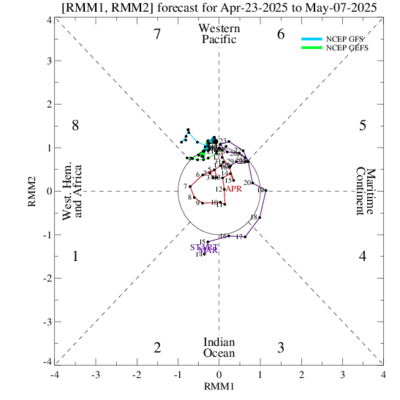
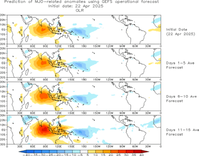
However, statistical guidence has the MJO pulse moving into the Western Pacific by about the middle of November, which would likely be accompanied with a marked uptick in tropical cyclone activity in the basin beginning around then and continuing into early December. This is in fairly stark contrast to the GFS's forecast.
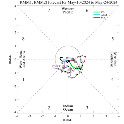
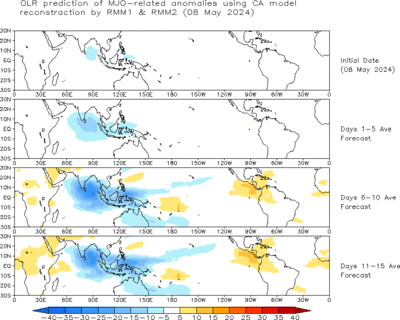
As of right now, recent verification seems to favor the statistical guidence over the GFS. 2 week verification for the GFS was outright bad with placement, although 1 week verification was somewhat better. Over both verification periods, the American numerical guidence has been handling the MJO amplitude fairly well, but been consistently too far west with the placement of the upward motion anomalies.
In contrast, statistical guidence maybe didn't grasp the MJO amplitude as well, but most did well overall for the 2 week verification period. It similarly did well for the last week of verification, although it was perhaps a little too progressive with the pulse.
All things considered, I'd lean towards the statistical guidence for the Madden-Julian progression over the next few weeks, but considering the spread between statistical guidence and American numerical guidence, it should also be stated that I have lower than normal confidence in this forecast. By the end of the week, it'll likely be more clear which guidence suite has the better handle on this MJO pulse. If the pulse progresses east, it'll probably be time to watch the Western Pacific basin again around November 15th or so. If the pulse stays put, chances are that the 2015 Western Pacific Typhoon Season is just about over.


However, statistical guidence has the MJO pulse moving into the Western Pacific by about the middle of November, which would likely be accompanied with a marked uptick in tropical cyclone activity in the basin beginning around then and continuing into early December. This is in fairly stark contrast to the GFS's forecast.


As of right now, recent verification seems to favor the statistical guidence over the GFS. 2 week verification for the GFS was outright bad with placement, although 1 week verification was somewhat better. Over both verification periods, the American numerical guidence has been handling the MJO amplitude fairly well, but been consistently too far west with the placement of the upward motion anomalies.
In contrast, statistical guidence maybe didn't grasp the MJO amplitude as well, but most did well overall for the 2 week verification period. It similarly did well for the last week of verification, although it was perhaps a little too progressive with the pulse.
All things considered, I'd lean towards the statistical guidence for the Madden-Julian progression over the next few weeks, but considering the spread between statistical guidence and American numerical guidence, it should also be stated that I have lower than normal confidence in this forecast. By the end of the week, it'll likely be more clear which guidence suite has the better handle on this MJO pulse. If the pulse progresses east, it'll probably be time to watch the Western Pacific basin again around November 15th or so. If the pulse stays put, chances are that the 2015 Western Pacific Typhoon Season is just about over.
0 likes
Contract Meteorologist. TAMU & MSST. Fiercely authentic, one of a kind. We are all given free will, so choose a life meant to be lived. We are the Masters of our own Stories.
Opinions expressed are mine alone.
Follow me on Twitter at @1900hurricane : Read blogs at https://1900hurricane.wordpress.com/
Opinions expressed are mine alone.
Follow me on Twitter at @1900hurricane : Read blogs at https://1900hurricane.wordpress.com/
-
euro6208
Re: 2015 WPAC Season
This is what NWS Guam had to say about this quietness. There may be renewed activity in the next few weeks.
You're right. Last week much of the tropical Pacific swung into a more dry-season mode. ENE trades are seen across much of the WPAC in our AOR. We do not see much chance of TC development this week...or early next week. Long-range models show a slight break down in the trades in E Micronesia next week making conditions marginally more favorable for something to develop. Globally, the tropics are very quiet this week, with only Cyclone Chapala in the Indian Ocean.
While we are experiencing dry season and trades this week...we cannot assume that it is here to stay. It is still possible to have another wave of tropical activity in the next month or two.
0 likes
I, personally, would favor the dampening of the MJO as it moves east and tries to cross the Maritime Continent. Just too much subsidence there and cool SST's, I'd guess it will reflect over to the Pacific by the second half of November.
0 likes
The above post and any post by Ntxw is NOT an official forecast and should not be used as such. It is just the opinion of the poster and may or may not be backed by sound meteorological data. It is NOT endorsed by any professional institution including Storm2k. For official information, please refer to NWS products.
-
euro6208
Re: 2015 WPAC Season
Models are split with development.
Previously NAVGEM has been showing a resurgence of activity with multiple TC developing near the dateline but has backed off showing nothing in the latest update.
CMC was showing twins with a possible typhoon but now shows only a single but strengthening system barreling towards the Marianas.
EURO and GFS basically nothing.
0 likes
- 1900hurricane
- Category 5

- Posts: 6063
- Age: 34
- Joined: Fri Feb 06, 2015 12:04 pm
- Location: Houston, TX
- Contact:
I'd lean away from dateline activity for the time being due to the downward pulse of Madden-Julian overspreading the area. Speaking of Madden-Julian though, it has been progressing east across the Indian Ocean nicely this week, although it still needs to cross the El Nino favored subsidence over the Maritime Continent. At it's current amplitude, the upward Madden-Julian pulse is a proven tropical cyclone producer, already helping to spawn Chapala and Megh, with it currently sitting over a third invest, so maybe a preview of what is still to come over the Western Pacific. Still liking my stated second half of November and into early December for possible tropical cyclone development.
0 likes
Contract Meteorologist. TAMU & MSST. Fiercely authentic, one of a kind. We are all given free will, so choose a life meant to be lived. We are the Masters of our own Stories.
Opinions expressed are mine alone.
Follow me on Twitter at @1900hurricane : Read blogs at https://1900hurricane.wordpress.com/
Opinions expressed are mine alone.
Follow me on Twitter at @1900hurricane : Read blogs at https://1900hurricane.wordpress.com/
-
euro6208
Re: 2015 WPAC Season
Indeed. EURO still keeping the basin quiet while GFS tries to develop a couple of struggling lows near the dateline. Nothing significant so far.
0 likes
Who is online
Users browsing this forum: No registered users and 177 guests


