ATL: KATE - Post-Tropical - Discussion
Moderator: S2k Moderators
- SouthDadeFish
- Professional-Met

- Posts: 2835
- Joined: Thu Sep 23, 2010 2:54 pm
- Location: Miami, FL
- Contact:
Re: ATL: INVEST 94L - Discussion
Good point about the surface pressures, NDG. One would expect at least a slight decrease if cyclogenesis was occurring.
0 likes
- cycloneye
- Admin

- Posts: 149278
- Age: 69
- Joined: Thu Oct 10, 2002 10:54 am
- Location: San Juan, Puerto Rico
Re: ATL: INVEST 94L - Discussion
Unless the surface low is south of the main area of convection.
0 likes
Visit the Caribbean-Central America Weather Thread where you can find at first post web cams,radars
and observations from Caribbean basin members Click Here
and observations from Caribbean basin members Click Here
Re: Re:
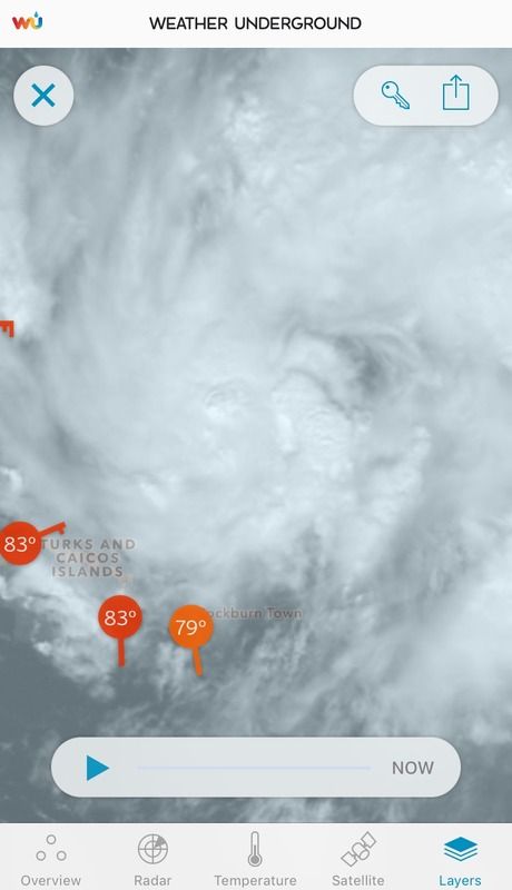
Hurricaneman wrote:NDG wrote:I must add that surface pressures have not fallen across the Turks & Caicos Islands during the past 24 hrs, pressures are high near 1015mb.
Well the center of low pressure would be east of there so the Turks and Caicos would have relative high pressures
The posts in this forum are NOT official forecast and should not be used as such. They are just the opinion of the poster and may or may not be backed by sound meteorological data. They are NOT endorsed by any professional institution or storm2k.org. For official information, please refer to the NHC and NWS products.
The surface pressures should had been falling by now with the circulation so close to them right now.
0 likes
- wxman57
- Moderator-Pro Met

- Posts: 23172
- Age: 68
- Joined: Sat Jun 21, 2003 8:06 pm
- Location: Houston, TX (southwest)
Re: ATL: INVEST 94L - Discussion
Central pressure may be only 1012-1013mb. It's not a very large system, so the Bahama obs may not reflect the LLC.
0 likes
Re:
AutoPenalti wrote:It looks to have weakened considerably.
... based on the latest cold towers appearing to pop close to the COC?? Of course, we've yet to determine whether this has worked its way to the surface in any way. I agree with Southdade in that such a small mesoscale type feature, it's quite possible that station obs that are not that far away, might not clearly show the wind direction or pressures to indicate a tiny low might be that close by. If I had to guess, I suppose its simply not quite down to the surface (but i would'nt bet my life on it lol)
0 likes
Andy D
(For official information, please refer to the NHC and NWS products.)
(For official information, please refer to the NHC and NWS products.)
- cycloneye
- Admin

- Posts: 149278
- Age: 69
- Joined: Thu Oct 10, 2002 10:54 am
- Location: San Juan, Puerto Rico
Re: ATL: INVEST 94L - Discussion
The real truth about the low will come in a few hours (21z) when the plane gets there and see how is the structure.
0 likes
Visit the Caribbean-Central America Weather Thread where you can find at first post web cams,radars
and observations from Caribbean basin members Click Here
and observations from Caribbean basin members Click Here
-
floridasun78
- Category 5

- Posts: 3755
- Joined: Sun May 17, 2009 10:16 pm
- Location: miami fl
- cycloneye
- Admin

- Posts: 149278
- Age: 69
- Joined: Thu Oct 10, 2002 10:54 am
- Location: San Juan, Puerto Rico
Re: ATL: INVEST 94L - Discussion
TROPICAL WEATHER OUTLOOK
NWS NATIONAL HURRICANE CENTER MIAMI FL
100 PM EST SUN NOV 8 2015
For the North Atlantic...Caribbean Sea and the Gulf of Mexico:
Shower and thunderstorm activity is showing signs of organization
in association with a low pressure system located just north of
the Turks and Caicos and the southeastern Bahamas. In addition,
satellite images indicate that the circulation of the low is
becoming better defined. Environmental conditions are expected
to be conducive for development of this system, and a tropical
depression or a tropical storm is likely to form tonight or on
Monday while the low moves west-northwestward to northwestward
near or over the central and northwestern Bahamas. Locally heavy
rains and gusty winds are possible across the Turks and Caicos and
most of the Bahamas during the next day or so. An Air Force Reserve
hurricane hunter aircraft is scheduled to investigate this system
Monday morning.
* Formation chance through 48 hours...high...70 percent
* Formation chance through 5 days...high...70 percent
$$
Forecaster Cangialosi/Stewart
0 likes
Visit the Caribbean-Central America Weather Thread where you can find at first post web cams,radars
and observations from Caribbean basin members Click Here
and observations from Caribbean basin members Click Here
Re:
floridasun78 wrote:it look moving nw on sat pic or eye playing trick
Your eyes are working just fine
0 likes
Andy D
(For official information, please refer to the NHC and NWS products.)
(For official information, please refer to the NHC and NWS products.)
- cycloneye
- Admin

- Posts: 149278
- Age: 69
- Joined: Thu Oct 10, 2002 10:54 am
- Location: San Juan, Puerto Rico
Re: ATL: INVEST 94L - Discussion
18z Best Track:
As of 18:00 UTC Nov 08, 2015:
Location: 22.1°N 71.4°W
Maximum Winds: 30 kt Gusts: N/A
Minimum Central Pressure: 1012 mb
Environmental Pressure: 1015 mb
Radius of Circulation: 120 NM
Radius of Maximum Wind: 40 NM
As of 18:00 UTC Nov 08, 2015:
Location: 22.1°N 71.4°W
Maximum Winds: 30 kt Gusts: N/A
Minimum Central Pressure: 1012 mb
Environmental Pressure: 1015 mb
Radius of Circulation: 120 NM
Radius of Maximum Wind: 40 NM
0 likes
Visit the Caribbean-Central America Weather Thread where you can find at first post web cams,radars
and observations from Caribbean basin members Click Here
and observations from Caribbean basin members Click Here
Re: ATL: INVEST 94L - Discussion
The wise observer would not ignore that quick improvement in Dvorak in this region. This area spawned an unexpected borderline category 5 hurricane not too long ago.
Very interesting system that might cause an unexpected media interest.
Still, it's moving pretty fast with a hard November front in front of it.
Very interesting system that might cause an unexpected media interest.
Still, it's moving pretty fast with a hard November front in front of it.
0 likes
-
tolakram
- Admin

- Posts: 20179
- Age: 62
- Joined: Sun Aug 27, 2006 8:23 pm
- Location: Florence, KY (name is Mark)
Re: ATL: INVEST 94L - Discussion
Visible loop. Very very small, if anything is there.
http://wwwghcc.msfc.nasa.gov/cgi-bin/get-goes?satellite=GOES-E%20CONUS&lat=24&lon=-72&info=vis&zoom=1&width=1000&height=800&quality=90&type=Animation&palette=ir1.pal&numframes=15&mapcolor=black
http://wwwghcc.msfc.nasa.gov/cgi-bin/get-goes?satellite=GOES-E%20CONUS&lat=24&lon=-72&info=vis&zoom=1&width=1000&height=800&quality=90&type=Animation&palette=ir1.pal&numframes=15&mapcolor=black
0 likes
M a r k
- - - - -
Join us in chat: Storm2K Chatroom Invite. Android and IOS apps also available.
The posts in this forum are NOT official forecasts and should not be used as such. Posts are NOT endorsed by any professional institution or STORM2K.org. For official information and forecasts, please refer to NHC and NWS products.
Re: ATL: INVEST 94L - Discussion
tolakram wrote:Visible loop. Very very small, if anything is there.
http://wwwghcc.msfc.nasa.gov/cgi-bin/get-goes?satellite=GOES-E%20CONUS&lat=24&lon=-72&info=vis&zoom=1&width=1000&height=800&quality=90&type=Animation&palette=ir1.pal&numframes=15&mapcolor=black
There appears to be a very tiny (and possibly closed) swirl on the extreme southern end of the convection.
0 likes
The above post is not official and should not be used as such. It is the opinion of the poster and may or may not be backed by sound meteorological data. It is not endorsed by any professional institution or storm2k.org. For official information, please refer to the NHC and NWS products.
-
ozonepete
- Professional-Met

- Posts: 4743
- Joined: Mon Sep 07, 2009 3:23 pm
- Location: From Ozone Park, NYC / Now in Brooklyn, NY
Re:
SouthDadeFish wrote:While I'm not saying there is a surface circulation, IF there was one, it would likely be quite small, and the stations in the Bahamas probably wouldn't reflect the fact that it existed. I'm starting to see signs of increased inflow from SE.
Yup. That is what I'm thinking. This is so small that it can consolidate an LLC very quickly and very likely is reaching the surface by now. As you said a 37ghz image would be awesome since that's the microwave frequency that gives us a look at the surface and lowest levels. I'm also waiting on some new 89ghz as well since we'll get to see the MLC which is already clearly detectable from the visible sats.
0 likes
-
ozonepete
- Professional-Met

- Posts: 4743
- Joined: Mon Sep 07, 2009 3:23 pm
- Location: From Ozone Park, NYC / Now in Brooklyn, NY
Re: Re:
ozonepete wrote:SouthDadeFish wrote:While I'm not saying there is a surface circulation, IF there was one, it would likely be quite small, and the stations in the Bahamas probably wouldn't reflect the fact that it existed. I'm starting to see signs of increased inflow from SE.
Yup. That is what I'm thinking. This is so small that it can consolidate an LLC very quickly and very likely is reaching the surface by now. As you said a 37ghz image would be awesome since that's the microwave frequency that gives us a look at the surface and lowest levels. I'm also waiting on some new 89ghz as well since we'll get to see the MLC which is already clearly detectable from the visible sats.
Well of course with RECON on the way we will get al of our answers...
0 likes
- cycloneye
- Admin

- Posts: 149278
- Age: 69
- Joined: Thu Oct 10, 2002 10:54 am
- Location: San Juan, Puerto Rico
Re: Re:
ozonepete wrote:ozonepete wrote:SouthDadeFish wrote:While I'm not saying there is a surface circulation, IF there was one, it would likely be quite small, and the stations in the Bahamas probably wouldn't reflect the fact that it existed. I'm starting to see signs of increased inflow from SE.
Yup. That is what I'm thinking. This is so small that it can consolidate an LLC very quickly and very likely is reaching the surface by now. As you said a 37ghz image would be awesome since that's the microwave frequency that gives us a look at the surface and lowest levels. I'm also waiting on some new 89ghz as well since we'll get to see the MLC which is already clearly detectable from the visible sats.
Well of course with RECON on the way we will get al of our answers...
Hi ozonepete.NHC changed their TCPOD this afternoon. (See recon thread) First mission will be at 5 AM EST Monday morning.
0 likes
Visit the Caribbean-Central America Weather Thread where you can find at first post web cams,radars
and observations from Caribbean basin members Click Here
and observations from Caribbean basin members Click Here
Who is online
Users browsing this forum: Google Adsense [Bot] and 76 guests


