Texas Fall-2015

U.S. & Caribbean Weather Discussions and Severe Weather Events

Moderator: S2k Moderators

Forum rules

The posts in this forum are NOT official forecast and should not be used as such. They are just the opinion of the poster and may or may not be backed by sound meteorological data. They are NOT endorsed by any professional institution or STORM2K.

Help Support Storm2K
Message
Author
gpsnowman
S2K Supporter
S2K Supporter
Posts: 3185
Joined: Fri Jan 07, 2011 10:35 am
Location: Grand Prairie Tx

Re:

#1801 Postby gpsnowman » Wed Nov 11, 2015 6:48 pm

Ralph's Weather wrote:So 18Z GFS is stronger next week with the low and with the EC ridge, but it sends the low NE instead of E like the 12Z did so no winter fun this round.

Nuri last November really helped us get things going. This year it looks like we have to wait for the orthodox progression of things to bring us cold and wintry type weather. I do believe the wait will be worth it due to the southern jet with El Nino. The local weather channels are offering not much hope in regards to the next seven days. Dang it, I want to feel some cold air. Craving it. :cold: :cold:
0 likes   

Brent
S2K Supporter
S2K Supporter
Posts: 38090
Age: 36
Joined: Sun May 16, 2004 10:30 pm
Location: Tulsa Oklahoma
Contact:

Re: Texas Fall-2015

#1802 Postby Brent » Wed Nov 11, 2015 7:24 pm

so close

Image
0 likes   
#neversummer

gpsnowman
S2K Supporter
S2K Supporter
Posts: 3185
Joined: Fri Jan 07, 2011 10:35 am
Location: Grand Prairie Tx

Re: Texas Fall-2015

#1803 Postby gpsnowman » Wed Nov 11, 2015 7:53 pm

Brent wrote:so close

Image

Looks like a trip to northern Kansas is in order. The maps are looking prettier and prettier. Brent, you are correct, the 80's today were just nasty. Felt like early May.
0 likes   

User avatar
Ntxw
Storm2k Moderator
Storm2k Moderator
Posts: 22785
Joined: Wed Oct 21, 2009 6:34 pm
Location: DFW, Texas

#1804 Postby Ntxw » Wed Nov 11, 2015 8:01 pm

It's still about a week away in terms of trying to pinpoint track. Either way it's not a high probability of wintry precip but I do like that it is trying. Models don't see the cold air work it's way into these kind of systems anyway until within 24-48 hours. For instance at the surface it sees middle 40s, 850s some -4C which is sufficient 5000ft above our heads.

Through next Weds it will feel very fall like, won't be much full sun...maybe a few hours Friday.
0 likes   
The above post and any post by Ntxw is NOT an official forecast and should not be used as such. It is just the opinion of the poster and may or may not be backed by sound meteorological data. It is NOT endorsed by any professional institution including Storm2k. For official information, please refer to NWS products.

  Help support Storm2K!
Help Support Storm2K

User avatar
TeamPlayersBlue
Category 5
Category 5
Posts: 3445
Joined: Tue Feb 02, 2010 1:44 am
Location: Denver/Applewood, CO

#1805 Postby TeamPlayersBlue » Wed Nov 11, 2015 8:24 pm

Yeah its a cold core no doubt, underneath it will produce snow. Ryan maues tweet yesterday showed an arctic connection too
0 likes   
Personal Forecast Disclaimer:
The posts in this forum are NOT official forecast and should not be used as such. They are just the opinion of the poster and may or may not be backed by sound meteorological data. They are NOT endorsed by any professional institution or storm2k.org. For official information, please refer to the NHC and NWS products.

User avatar
Ntxw
Storm2k Moderator
Storm2k Moderator
Posts: 22785
Joined: Wed Oct 21, 2009 6:34 pm
Location: DFW, Texas

#1806 Postby Ntxw » Wed Nov 11, 2015 8:47 pm

Interesting the lake effect snows off Tahoe into Reno earlier this week. Well more lake enhanced if anything. I propose we expand Lake Texoma by four fold :cheesy:

http://news.weathernationtv.com/2015/11/10/biggest-little-city-world-sees-huge-lake-effect-snow/
0 likes   
The above post and any post by Ntxw is NOT an official forecast and should not be used as such. It is just the opinion of the poster and may or may not be backed by sound meteorological data. It is NOT endorsed by any professional institution including Storm2k. For official information, please refer to NWS products.


  Help support Storm2K!

Help Support Storm2K


Brent
S2K Supporter
S2K Supporter
Posts: 38090
Age: 36
Joined: Sun May 16, 2004 10:30 pm
Location: Tulsa Oklahoma
Contact:

Re: Texas Fall-2015

#1807 Postby Brent » Wed Nov 11, 2015 9:34 pm

gpsnowman wrote:
Brent wrote:so close

Image

Looks like a trip to northern Kansas is in order. The maps are looking prettier and prettier. Brent, you are correct, the 80's today were just nasty. Felt like early May.


The 6z was closer with that ridiculous bullseye

Image
0 likes   
#neversummer

aggiecutter
Category 5
Category 5
Posts: 1753
Joined: Thu Oct 14, 2004 9:22 pm
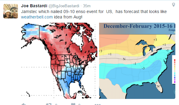
Location: Texarkana

Re: Texas Fall-2015

#1808 Postby aggiecutter » Wed Nov 11, 2015 10:31 pm

Image
0 likes   

User avatar
Ntxw
Storm2k Moderator
Storm2k Moderator
Posts: 22785
Joined: Wed Oct 21, 2009 6:34 pm
Location: DFW, Texas

#1809 Postby Ntxw » Wed Nov 11, 2015 11:09 pm

Well to be fair to everyone else, that's pretty much what all others are forecasting. Basic El Nino climo :wink:. Different flavors of the same thing! One of the easiest forecast in years.
0 likes   
The above post and any post by Ntxw is NOT an official forecast and should not be used as such. It is just the opinion of the poster and may or may not be backed by sound meteorological data. It is NOT endorsed by any professional institution including Storm2k. For official information, please refer to NWS products.


  Help support Storm2K!

Help Support Storm2K


Ralph's Weather
S2K Supporter
S2K Supporter
Posts: 3269
Age: 38
Joined: Fri Dec 13, 2013 11:55 am
Location: Lindale, TX
Contact:

#1810 Postby Ralph's Weather » Wed Nov 11, 2015 11:45 pm

0Z GFS similar to 18Z though even deeper with the low. We get storms Tuesday morning then cool air rushes in during the day. Look for Tue and Wed to be much cooler than forecasted right now. The low moves NNE slowly from the Panhandle on Tuesday to Iowa on Thursday. To me our shot for winter weather would be if the New England ridge sets us off the coast instead which should make our system take a flatter path east.
Last edited by Ralph's Weather on Thu Nov 12, 2015 12:14 am, edited 1 time in total.
0 likes   
Follow on Facebook at Ralph's Weather.

Brent
S2K Supporter
S2K Supporter
Posts: 38090
Age: 36
Joined: Sun May 16, 2004 10:30 pm
Location: Tulsa Oklahoma
Contact:

Re: Texas Fall-2015

#1811 Postby Brent » Thu Nov 12, 2015 12:12 am

OMG the storm at 372-384 hours would be a Black Friday surprise. :P

Image

Image
0 likes   
#neversummer

User avatar
SouthernMet
Category 3
Category 3
Posts: 857
Joined: Sun Aug 29, 2010 8:23 pm
Location: fort worth, tx

Re: Texas Fall-2015

#1812 Postby SouthernMet » Thu Nov 12, 2015 12:18 am

:uarrow: Brent beat me to it :wink:
0 likes   
Nothing that SouthernMet posts, is an official forecast,nor does it reflect views of STORM2K.. SouthernMet is just adding to the great discussions on STORM2K.. Refer to NWS for official forecasts.

Ralph's Weather
S2K Supporter
S2K Supporter
Posts: 3269
Age: 38
Joined: Fri Dec 13, 2013 11:55 am
Location: Lindale, TX
Contact:

Re: Texas Fall-2015

#1813 Postby Ralph's Weather » Thu Nov 12, 2015 12:23 am

Brent wrote:OMG the storm at 372-384 hours would be a Black Friday surprise. :P

Looks fun. Overall message is winter is now open for business. Our weekly storms now have chances to include frozen precip. Not all will produce but some will. Also we are into storm season again especially over E TX with these dynamic lows.
0 likes   
Follow on Facebook at Ralph's Weather.

Brent
S2K Supporter
S2K Supporter
Posts: 38090
Age: 36
Joined: Sun May 16, 2004 10:30 pm
Location: Tulsa Oklahoma
Contact:

Re: Texas Fall-2015

#1814 Postby Brent » Thu Nov 12, 2015 1:36 am

Ralph's Weather wrote:
Brent wrote:OMG the storm at 372-384 hours would be a Black Friday surprise. :P

Looks fun. Overall message is winter is now open for business. Our weekly storms now have chances to include frozen precip. Not all will produce but some will. Also we are into storm season again especially over E TX with these dynamic lows.


Even before that storm... the 0z GFS has much below normal temperatures starting at day 10... with some lows near freezing around DFW and highs in the 40s or low 50s mostly. The 372 hour storm starts as a cold rain on Thanksgiving Day.
0 likes   
#neversummer

User avatar
srainhoutx
S2K Supporter
S2K Supporter
Posts: 6919
Age: 67
Joined: Sun Jan 14, 2007 11:34 am
Location: Haywood County, NC
Contact:

Re: Texas Fall-2015

#1815 Postby srainhoutx » Thu Nov 12, 2015 8:02 am

The overnight guidance continues to advertise a powerful negative tilted trough moving out of the Southern Rockies Sunday into Monday and marching across Texas and Louisiana into Tuesday. If these trends continue, except to see all modes of severe weather possible including a threat for super cells and a possible tornado risk across portions of Central, East, SE Texas extending into Louisiana next Monday into Tuesday.

In the wake of this powerful late Fall/early Winter storm, expect the coldest air of the Season to spread South all the way to the Gulf Coast mid to late next week. Stay tuned folks. This storm system has the potential to be a Major Weather event across the Region.
0 likes   
Carla/Alicia/Jerry(In The Eye)/Michelle/Charley/Ivan/Dennis/Katrina/Rita/Wilma/Ike/Harvey

Member: National Weather Association
Wx Infinity Forums
http://wxinfinity.com/index.php

Facebook.com/WeatherInfinity
Twitter @WeatherInfinity

User avatar
Portastorm
Storm2k Moderator
Storm2k Moderator
Posts: 9914
Age: 63
Joined: Fri Jul 11, 2003 9:16 am
Location: Round Rock, TX
Contact:

Re: Texas Fall-2015

#1816 Postby Portastorm » Thu Nov 12, 2015 9:28 am

In lieu of the overnight 0z GFS operational run, the Portastorm Weather Center meteorologists have placed the season's first order of Grey Goose online from manufacturers with hopes that said supply can be kept cold outside. :wink:

As srainhoutx said ... stay tuned.
0 likes   
Any forecasts under my name are to be taken with a grain of salt. Get your best forecasts from the National Weather Service and National Hurricane Center.

Ralph's Weather
S2K Supporter
S2K Supporter
Posts: 3269
Age: 38
Joined: Fri Dec 13, 2013 11:55 am
Location: Lindale, TX
Contact:

#1817 Postby Ralph's Weather » Thu Nov 12, 2015 9:55 am

Anyone make the 30s last night? I had 44. Better chance tomorrow morning.
0 likes   
Follow on Facebook at Ralph's Weather.

User avatar
Tireman4
S2K Supporter
S2K Supporter
Posts: 5853
Age: 59
Joined: Fri Jun 30, 2006 1:08 pm
Location: Humble, Texas
Contact:

Re: Texas Fall-2015

#1818 Postby Tireman4 » Thu Nov 12, 2015 10:58 am

srainhoutx wrote:The overnight guidance continues to advertise a powerful negative tilted trough moving out of the Southern Rockies Sunday into Monday and marching across Texas and Louisiana into Tuesday. If these trends continue, except to see all modes of severe weather possible including a threat for super cells and a possible tornado risk across portions of Central, East, SE Texas extending into Louisiana next Monday into Tuesday.

In the wake of this powerful late Fall/early Winter storm, expect the coldest air of the Season to spread South all the way to the Gulf Coast mid to late next week. Stay tuned folks. This storm system has the potential to be a Major Weather event across the Region.


Stepping down, maybe? :)
0 likes   

User avatar
Ntxw
Storm2k Moderator
Storm2k Moderator
Posts: 22785
Joined: Wed Oct 21, 2009 6:34 pm
Location: DFW, Texas

#1819 Postby Ntxw » Thu Nov 12, 2015 11:13 am

I'm going out on a limb and make a bold forecast that Austin will see freezing drizzle within the next 6 weeks.
0 likes   
The above post and any post by Ntxw is NOT an official forecast and should not be used as such. It is just the opinion of the poster and may or may not be backed by sound meteorological data. It is NOT endorsed by any professional institution including Storm2k. For official information, please refer to NWS products.


  Help support Storm2K!

Help Support Storm2K


User avatar
Portastorm
Storm2k Moderator
Storm2k Moderator
Posts: 9914
Age: 63
Joined: Fri Jul 11, 2003 9:16 am
Location: Round Rock, TX
Contact:

Re:

#1820 Postby Portastorm » Thu Nov 12, 2015 11:14 am

Ntxw wrote:I'm going out on a limb and make a bold forecast that Austin will see freezing drizzle within the next 6 weeks.


I'm afraid you're right, sir. We take our moniker of "Freezing Drizzle Capital of Texas" seriously around here. :roll:
0 likes   
Any forecasts under my name are to be taken with a grain of salt. Get your best forecasts from the National Weather Service and National Hurricane Center.


Return to “USA & Caribbean Weather”

Who is online

Users browsing this forum: No registered users and 18 guests