Texas Fall-2015

U.S. & Caribbean Weather Discussions and Severe Weather Events

Moderator: S2k Moderators

Forum rules

The posts in this forum are NOT official forecast and should not be used as such. They are just the opinion of the poster and may or may not be backed by sound meteorological data. They are NOT endorsed by any professional institution or STORM2K.

Help Support Storm2K
Message
Author
Ralph's Weather
S2K Supporter
S2K Supporter
Posts: 3269
Age: 38
Joined: Fri Dec 13, 2013 11:55 am
Location: Lindale, TX
Contact:

Re: Texas Fall-2015

#2121 Postby Ralph's Weather » Fri Nov 20, 2015 9:35 am

wxman57 wrote:Last few runs of the GFS (and 00Z Euro) keep the snow out of NE TX over the next 10 days. Some snow for the Panhandle, but that's about it. May still be a bit early to start thinking frozen precip in the D-FW area.

Looks like the models are losing the strong -EPO.
0 likes   
Follow on Facebook at Ralph's Weather.

User avatar
dhweather
S2K Supporter
S2K Supporter
Posts: 6199
Joined: Sat Aug 14, 2004 9:29 pm
Location: Heath, TX
Contact:

Re:

#2122 Postby dhweather » Fri Nov 20, 2015 9:43 am

gboudx wrote:Good thing those graphics SouthernMet posted are over a week out, because that's about the ugliest forecast I've seen. Power outages lasting a long time almost a sure bet. Just ugly.


Correct, sir. That would be one of those storms people talk about for decades.
0 likes   
The above post and any post by dhweather is NOT an official forecast and should not be used as such. It is just the opinion of the poster and may or may not be backed by sound meteorological data. It is NOT endorsed by any professional institution including storm2k.org. For official information, please refer to NWS products.

User avatar
dhweather
S2K Supporter
S2K Supporter
Posts: 6199
Joined: Sat Aug 14, 2004 9:29 pm
Location: Heath, TX
Contact:

Re: Texas Fall-2015

#2123 Postby dhweather » Fri Nov 20, 2015 9:45 am

wxman57 wrote:Last few runs of the GFS (and 00Z Euro) keep the snow out of NE TX over the next 10 days. Some snow for the Panhandle, but that's about it. May still be a bit early to start thinking frozen precip in the D-FW area.


All I want for Christmas is for Porta to get him some snow, he deserves much better than persistent freezing drizzle.
0 likes   
The above post and any post by dhweather is NOT an official forecast and should not be used as such. It is just the opinion of the poster and may or may not be backed by sound meteorological data. It is NOT endorsed by any professional institution including storm2k.org. For official information, please refer to NWS products.

User avatar
TeamPlayersBlue
Category 5
Category 5
Posts: 3445
Joined: Tue Feb 02, 2010 1:44 am
Location: Denver/Applewood, CO

#2124 Postby TeamPlayersBlue » Fri Nov 20, 2015 9:58 am

GFS, dont you dare!!!!
0 likes   
Personal Forecast Disclaimer:
The posts in this forum are NOT official forecast and should not be used as such. They are just the opinion of the poster and may or may not be backed by sound meteorological data. They are NOT endorsed by any professional institution or storm2k.org. For official information, please refer to the NHC and NWS products.

orangeblood
S2K Supporter
S2K Supporter
Posts: 3714
Joined: Tue Dec 15, 2009 6:14 pm
Location: Fort Worth, TX

Re: Texas Fall-2015

#2125 Postby orangeblood » Fri Nov 20, 2015 10:32 am

Ralph's Weather wrote:
wxman57 wrote:Last few runs of the GFS (and 00Z Euro) keep the snow out of NE TX over the next 10 days. Some snow for the Panhandle, but that's about it. May still be a bit early to start thinking frozen precip in the D-FW area.

Looks like the models are losing the strong -EPO.


Both the GFS and Canadian have similar synoptic setups for next weekend....the Euro looks lost with it's typical Southwest US bias towards dragging ULLs back too far southwest!!! If the Pacific Ridge can hold on long enough allowing Arctic Air to dig far enough south, I would expect a fairly decent winter storm next weekend for someone in the southern plains.
0 likes   

User avatar
TheProfessor
Professional-Met
Professional-Met
Posts: 3506
Age: 28
Joined: Tue Dec 03, 2013 10:56 am
Location: Wichita, Kansas

#2126 Postby TheProfessor » Fri Nov 20, 2015 10:57 am

:uarrow: pls no for North Texas :(
0 likes   
An alumnus of The Ohio State University.

Your local National Weather Service office is your best source for weather information.

User avatar
Portastorm
Storm2k Moderator
Storm2k Moderator
Posts: 9914
Age: 63
Joined: Fri Jul 11, 2003 9:16 am
Location: Round Rock, TX
Contact:

Re: Texas Fall-2015

#2127 Postby Portastorm » Fri Nov 20, 2015 11:27 am

dhweather wrote:
wxman57 wrote:Last few runs of the GFS (and 00Z Euro) keep the snow out of NE TX over the next 10 days. Some snow for the Panhandle, but that's about it. May still be a bit early to start thinking frozen precip in the D-FW area.


All I want for Christmas is for Porta to get him some snow, he deserves much better than persistent freezing drizzle.


Look ... what can make this one of those BOGO things ... Austin gets some snow this winter and Heath gets ample rainfall for the next 12 months. That's asking too much, is it?! :wink: :cheesy:

At the moment, I'm actually pretty skeptical of anything "frozen" impacting any area south/southeast of a Wichita Falls-Lubbock line next weekend. With the given Nino pattern, some kind of very wet and slow frontal progression seems more likely. But there still is a long ways to go.
0 likes   
Any forecasts under my name are to be taken with a grain of salt. Get your best forecasts from the National Weather Service and National Hurricane Center.

User avatar
srainhoutx
S2K Supporter
S2K Supporter
Posts: 6919
Age: 67
Joined: Sun Jan 14, 2007 11:34 am
Location: Haywood County, NC
Contact:

Re: Texas Fall-2015

#2128 Postby srainhoutx » Fri Nov 20, 2015 11:41 am

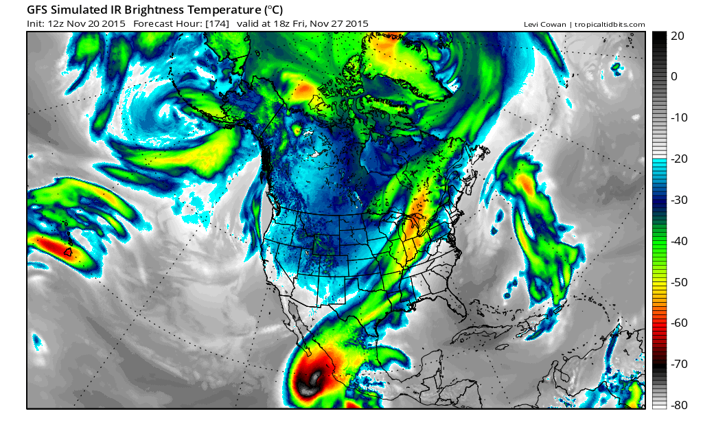
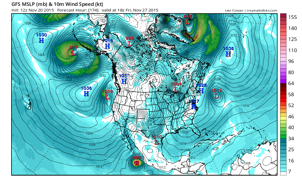
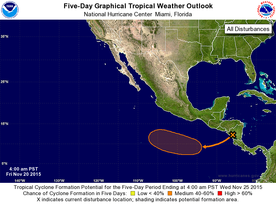
The morning Updated Extended Outlook from the Weather Prediction Center is offering clues as to what we can expect for Thanksgiving. Also, the 12Z GFS is indicating a tropical cyclone lurking off the West Coast of Mexico as the Arctic boundary begins to advance toward Texas Thanksgiving Day.


EXTENDED FORECAST DISCUSSION
NWS WEATHER PREDICTION CENTER COLLEGE PARK MD
1100 AM EST FRI NOV 20 2015

VALID 12Z MON NOV 23 2015 - 12Z FRI NOV 27 2015

...WHITE THANKSGIVING LIKELY FOR MUCH OF THE CENTRAL/NORTHERN
ROCKIES INTO THE PLAINS...


...MUCH COLDER TEMPERATURES FOR THE WESTERN HALF OF THE COUNTRY...


...OVERVIEW...

SEESAW IN THE HEIGHT PATTERN WILL PLAY OUT NEXT WEEK OVER THE
LOWER 48. INITIAL MODEST RIDGING IN THE WEST AND TROUGHING IN THE
EAST WILL REVERSE ITSELF BY WEDNESDAY AS A STRONG UPPER LOW DIGS
SOUTHWARD THROUGH THE INTERMOUNTAIN WEST. THIS IS IN RESPONSE TO
ANOTHER UPSTREAM TROUGH/RIDGE COUPLET ACROSS ALASKA AND THE
NORTHEAST PACIFIC INTO WESTERN CANADA. MODELS AND ENSEMBLES REMAIN
IN GOOD AGREEMENT ON THE LONGWAVE EVOLUTION AND EVEN SHOW BETTER
AGREEMENT THAN 24 HRS AGO WITH SOME DETAILS, THOUGH THOSE CAN AND
OFTEN DO CHANGE. THIS PATTERN SUPPORTS A SIGNIFICANT DUMP OF COLD
AIR THROUGH THE WESTERN STATES WITH WINDY AND SHOWERY/SNOWY
CONDITIONS FOR MANY AREAS LEADING INTO THE VERY BUSY TRAVEL DAYS
AND THANKSGIVING ITSELF.


...GUIDANCE EVALUATION/PREFERENCES...

FOR THE FIRST PART OF THE FORECAST, MON-WED, A MODEL/ENSEMBLE
CONSENSUS BLEND OFFERS A REASONABLE STARTING POINT ACROSS THE
CONUS. ECMWF LIES ON THE STRONGER SIDE WITH MID-LEVEL SHORTWAVE
ENERGY PUSHING INTO CALIFORNIA BUT THEN WEAKENING MON-TUE BUT
OTHERWISE FALLS WELL WITHIN THE ENSEMBLE SPREAD ALONG WITH THE
06Z/00Z GFS. TROUGH SWINGING OFF THE EAST COAST WILL SUPPORT A
SURFACE LOW ALONG THE FRONTAL BOUNDARY ON MONDAY THAT SHOULD STAY
JUST OFFSHORE WITH ITS PRECIP SHIELD, EXCEPT FOR MAYBE CAPE COD
AND ALONG I-95 NORTHWARD INTO MAINE. IT WOULD NOT TAKE MUCH TO
NUDGE THIS FARTHER WEST BUT THE ENSEMBLE CONSENSUS TILTS TOWARD
KEEPING THE PRECIP OFFSHORE FOR NOW.

IN THE WEST, DETERMINISTIC MODELS HAVE CONVERGED ON KEEPING A MORE
COHERENT UPPER LOW IN THE WESTERN STATES INTO NEXT FRIDAY RATHER
THAN SENDING ENERGY THROUGH THE PLAINS AROUND THURSDAY, REFLECTED
AS A STRONGER AREA OF SURFACE LOW PRESSURE. LEAD COLD FRONTAL
BOUNDARY WILL BRING WITH IT THE COLDER AIRMASS OF THE SEASON INTO
THE REGION WEST OF THE DIVIDE EARLY IN THE WEEK. CANADIAN
ENSEMBLES SHOW MORE TROUGHING THAN 24 HRS AGO BUT ARE STILL
WEAKER, THUS AFFECTING THE NAEFS MEAN. ARCTIC FRONT ON ITS HEELS
IS FORECAST TO CATCH UP TO THE FIRST BOUNDARY AROUND WED-THU AS
THE EASTERN EDGE SLOWS ITS PROGRESS THROUGH MN/WI/IA. THIS WILL
SET UP A GOOD UPSLOPE AN OVERRUNNING EVENT FOR THE UPPER MIDWEST
BACK THROUGH THE HIGH PLAINS INTO THE CENTRAL/NORTHERN ROCKIES
TUE-THU. UPSTREAM, ENSEMBLES ARE HAVING A TOUGH TIME WITH THE
BLOCKY NORTH PACIFIC FLOW BUT PREFER TO KEEP THE RIDGE IN PLACE
OVER BRITISH COLUMBIA THROUGH THE WEEK, THOUGH PERHAPS TILTED
EASTWARD, PER THE 00Z ECMWF/ECENS MEAN AND 06Z GEFS MEAN RATHER
THAN EAT INTO IT OR DESTROY IT PER THE 00Z/06Z GFS, RESPECTIVELY.
TIMING OF THE FRONT REMAINS A CHALLENGE AS THE COLD AIR RUSHES
SOUTHWARD EAST OF THE TERRAIN IN CO AND WESTERN KS/NE. ECMWF MAY
BE TOO SLOW WITH THE FRONT GIVEN THE COLD AIRMASS. THUS, A TREND
TOWARD THE 00Z GEFS/ECENS MEAN WAS INCORPORATED TO IRON OUT SOME
DETERMINISTIC DIFFERENCES.


...SENSIBLE WEATHER HIGHLIGHTS...

COLD, SNOW, AND WIND WILL AFFECT MUCH OF THE NORTHERN/CENTRAL
ROCKIES AS THE LEAD BOUNDARY PASSES BY, ACCENTUATED BY THE ARCTIC
FRONT. TRAVEL WILL BECOME MORE DIFFICULT WITH BLOWING SNOW LIKELY
IN THESE REGIONS. WIND CHILL TEMPERATURES ON WED-FRI WILL BE BELOW
ZERO FOR A SIZABLE AREA OF WY/MT/ID. SNOW TREAT WILL SPREAD INTO
THE HIGH PLAINS BY FRIDAY AS THE FRONT SINKS SOUTHWARD AND A BIT
EASTWARD. TEMPERATURES ARE FORECAST TO BE 10-25F BELOW AVERAGE
OVER THE ROCKIES/HIGH PLAINS. TEMPS MAY NOT THREATEN DAILY RECORDS
BUT WILL STILL FEEL QUITE COLD GIVEN THE ROCKIES/PLAINS HAVE
AVERAGED ABOVE NORMAL FOR THE MONTH THUS FAR. AS THE LEADING COLD
FRONT BEGINS TO INTERACT WITH GULF MOISTURE, WARM SECTOR RAINFALL
SHOULD INCREASE IN COVERAGE/INTENSITY BY THE LATTER HALF OF THE
WEEK


FRACASSO/RAUSCH


Image

Image

Image
0 likes   
Carla/Alicia/Jerry(In The Eye)/Michelle/Charley/Ivan/Dennis/Katrina/Rita/Wilma/Ike/Harvey

Member: National Weather Association
Wx Infinity Forums
http://wxinfinity.com/index.php

Facebook.com/WeatherInfinity
Twitter @WeatherInfinity

User avatar
TheProfessor
Professional-Met
Professional-Met
Posts: 3506
Age: 28
Joined: Tue Dec 03, 2013 10:56 am
Location: Wichita, Kansas

#2129 Postby TheProfessor » Fri Nov 20, 2015 11:43 am

And so far the 12zGFS has brought back the ice storm for Saturday the 28th :roll:
0 likes   
An alumnus of The Ohio State University.

Your local National Weather Service office is your best source for weather information.

Ralph's Weather
S2K Supporter
S2K Supporter
Posts: 3269
Age: 38
Joined: Fri Dec 13, 2013 11:55 am
Location: Lindale, TX
Contact:

#2130 Postby Ralph's Weather » Fri Nov 20, 2015 11:54 am

12Z GFS has come back to reality though it still probably breaks down the WC ridge too much. If the E Pac storm does indeed recurve into Mexico sometime next weekend then we could be dealing with a significant winter storm.
0 likes   
Follow on Facebook at Ralph's Weather.

User avatar
TheProfessor
Professional-Met
Professional-Met
Posts: 3506
Age: 28
Joined: Tue Dec 03, 2013 10:56 am
Location: Wichita, Kansas

Re:

#2131 Postby TheProfessor » Fri Nov 20, 2015 11:56 am

Ralph's Weather wrote:12Z GFS has come back to reality though it still probably breaks down the WC ridge too much. If the E Pac storm does indeed recurve into Mexico sometime next weekend then we could be dealing with a significant winter storm.


Imma be Wxman after this weekend just this once, because getting back to Ohio to take my Midterm > being trapped in Texas due to an Ice/snow storm. Though Snow shouldn't close the Airport multiple days like Ice could.
0 likes   
An alumnus of The Ohio State University.

Your local National Weather Service office is your best source for weather information.

Ralph's Weather
S2K Supporter
S2K Supporter
Posts: 3269
Age: 38
Joined: Fri Dec 13, 2013 11:55 am
Location: Lindale, TX
Contact:

Re: Re:

#2132 Postby Ralph's Weather » Fri Nov 20, 2015 12:00 pm

TheProfessor wrote:
Ralph's Weather wrote:12Z GFS has come back to reality though it still probably breaks down the WC ridge too much. If the E Pac storm does indeed recurve into Mexico sometime next weekend then we could be dealing with a significant winter storm.


Imma be Wxman after this weekend just this once, because getting back to Ohio to take my Midterm > being trapped in Texas due to an Ice/snow storm. Though Snow shouldn't close the Airport multiple days like Ice could.

I sure hope it is snow or rain, but snow does not look likely except maybe at the end. It will be very interesting to see how a landfalling E Pac system plus a Arctic air mass interact as it is such a rare combo.
0 likes   
Follow on Facebook at Ralph's Weather.

User avatar
TheProfessor
Professional-Met
Professional-Met
Posts: 3506
Age: 28
Joined: Tue Dec 03, 2013 10:56 am
Location: Wichita, Kansas

#2133 Postby TheProfessor » Fri Nov 20, 2015 12:00 pm

12z GFS doesn't have Temps above freezing in North Texas from Saturday morning (12z) till Tuesday evening (0z). of course there could be a 20z temp in there that makes it above freezing.
0 likes   
An alumnus of The Ohio State University.

Your local National Weather Service office is your best source for weather information.

User avatar
Ntxw
Storm2k Moderator
Storm2k Moderator
Posts: 22784
Joined: Wed Oct 21, 2009 6:34 pm
Location: DFW, Texas

#2134 Postby Ntxw » Fri Nov 20, 2015 12:06 pm

12z GFS is basically a significant ice storm next weekend for NW and N Tx
0 likes   
The above post and any post by Ntxw is NOT an official forecast and should not be used as such. It is just the opinion of the poster and may or may not be backed by sound meteorological data. It is NOT endorsed by any professional institution including Storm2k. For official information, please refer to NWS products.

  Help support Storm2K!
Help Support Storm2K

User avatar
TheProfessor
Professional-Met
Professional-Met
Posts: 3506
Age: 28
Joined: Tue Dec 03, 2013 10:56 am
Location: Wichita, Kansas

Re:

#2135 Postby TheProfessor » Fri Nov 20, 2015 12:14 pm

Ntxw wrote:12z GFS is basically a significant ice storm next weekend for NW and N Tx

It showed 10-12 inches of snow in west Texas, but it shows them getting only Ice, would you have to do your snow to rain to ice conversions or would that be 12 inches of ice/sleet? :eek:
0 likes   
An alumnus of The Ohio State University.

Your local National Weather Service office is your best source for weather information.

User avatar
Ntxw
Storm2k Moderator
Storm2k Moderator
Posts: 22784
Joined: Wed Oct 21, 2009 6:34 pm
Location: DFW, Texas

#2136 Postby Ntxw » Fri Nov 20, 2015 12:18 pm

Sleet and ice ratio's is much less than snow. You would have to do a skew T to figure that out

Sometimes the map sources have a tough time calculating these ratio's and precip types. Not always the fault of the model bc models dont put out snow/ice only temps and qpf. Its up to the interpreting to figure that out.
0 likes   
The above post and any post by Ntxw is NOT an official forecast and should not be used as such. It is just the opinion of the poster and may or may not be backed by sound meteorological data. It is NOT endorsed by any professional institution including Storm2k. For official information, please refer to NWS products.


  Help support Storm2K!

Help Support Storm2K


User avatar
TheProfessor
Professional-Met
Professional-Met
Posts: 3506
Age: 28
Joined: Tue Dec 03, 2013 10:56 am
Location: Wichita, Kansas

Re:

#2137 Postby TheProfessor » Fri Nov 20, 2015 12:21 pm

Ntxw wrote:Sleet and ice ratio's is much less than snow. You would have to do a skew T to figure that out

Sometimes the map sources have a tough time calculating these ratio's and precip types. Not always the fault of the model bc models dont put out snow/ice only temps and qpf. Its up to the interpreting to figure that out.


ok
0 likes   
An alumnus of The Ohio State University.

Your local National Weather Service office is your best source for weather information.

Wntrwthrguy
Tropical Storm
Tropical Storm
Posts: 161
Joined: Thu Nov 21, 2013 8:48 pm
Location: North Austin

#2138 Postby Wntrwthrguy » Fri Nov 20, 2015 12:23 pm

What is Austin's weather next weekend looking like?
0 likes   
Any post should not be taken as a forecast. I am just an amateur living the dream.

User avatar
TheProfessor
Professional-Met
Professional-Met
Posts: 3506
Age: 28
Joined: Tue Dec 03, 2013 10:56 am
Location: Wichita, Kansas

Re:

#2139 Postby TheProfessor » Fri Nov 20, 2015 12:25 pm

Wntrwthrguy wrote:What is Austin's weather next weekend looking like?


Way too Early too Tell but 12z GFS and CMC look like it has icy weather for maybe the Western Portions, I can't tell exaclty where Austin is on the map.
0 likes   
An alumnus of The Ohio State University.

Your local National Weather Service office is your best source for weather information.

User avatar
TheProfessor
Professional-Met
Professional-Met
Posts: 3506
Age: 28
Joined: Tue Dec 03, 2013 10:56 am
Location: Wichita, Kansas

#2140 Postby TheProfessor » Fri Nov 20, 2015 12:27 pm

up to a 60% chance of rain/snow for me tomorrow night. All the good snow will be to my north and northwest. Wish I were in Chicago right now. :(
0 likes   
An alumnus of The Ohio State University.

Your local National Weather Service office is your best source for weather information.


Return to “USA & Caribbean Weather”

Who is online

Users browsing this forum: AnnularCane and 11 guests