Texas Fall-2015
Moderator: S2k Moderators
Forum rules

The posts in this forum are NOT official forecast and should not be used as such. They are just the opinion of the poster and may or may not be backed by sound meteorological data. They are NOT endorsed by any professional institution or STORM2K.
-
Ralph's Weather
- S2K Supporter

- Posts: 3371
- Age: 38
- Joined: Fri Dec 13, 2013 11:55 am
- Location: Lindale, TX
- Contact:
Looking at the skewTs for DFW it shows the transition from ice to snow around 3AM Saturday, ice could start near midnight. For Tyler it shows little period for icing and snow by late Saturday morning. It would be awesome if the cold ends up as deep as shown here. Looking at the 500mb vort maps as I think is what is being indicated by Cavanaugh the vort is much further south than on the 12Z all the way into OK during the heart of the event. I think the reason for it making it further south is because of the lack of a SW upper low anchoring it.
0 likes
Follow on Facebook at Ralph's Weather.
-
Brent
- S2K Supporter
- Posts: 38737
- Age: 37
- Joined: Sun May 16, 2004 10:30 pm
- Location: Tulsa Oklahoma
- Contact:
Re: Texas Fall-2015
You can pick out snow cover around DFW all the way to 360 hours on the 2m maps...  a week after the storm


0 likes
#neversummer
-
Ralph's Weather
- S2K Supporter
- Posts: 3371
- Age: 38
- Joined: Fri Dec 13, 2013 11:55 am
- Location: Lindale, TX
- Contact:
And the 18Z GFS ensembles show no winter weather. Euro shows 850mb temps in the 50s on Saturday. I am sure we will have several more dream runs over the next week.
0 likes
Follow on Facebook at Ralph's Weather.
-
Brent
- S2K Supporter
- Posts: 38737
- Age: 37
- Joined: Sun May 16, 2004 10:30 pm
- Location: Tulsa Oklahoma
- Contact:
Re: Texas Fall-2015
The 18z GFS meteogram is out
at DFW
Friday temperatures fall all day from the 60s at midnight Thanksgiving to the 40s by mid morning to the freezing mark around midnight Friday Night. Precip is falling all day though the heaviest is in the overnight hours both Thanksgiving Night and Friday Night(when temps are down near or below freezing)
Saturday the precip ends in the afternoon and temps continue to fall down towards single digits Sunday morning(9 degrees and 10 degrees) for two separate lows. This run is back above freezing albeit barely by Monday but remains in the 40s for highs most of the run.
0 likes
#neversummer
-
Brent
- S2K Supporter
- Posts: 38737
- Age: 37
- Joined: Sun May 16, 2004 10:30 pm
- Location: Tulsa Oklahoma
- Contact:
Re:
gpsnowman wrote:On the CBS11 7 day, the Friday after Thanksgiving high is forecasted to be 45 with rain. We will see if the temps drop lower as the days go by. It is going to be a fun week ahead starting off the holiday season with some potential winter fun.
Pete Delkus had 46 on Friday with a down arrow and mentioned "icemaggedon" for Friday Night/Saturday
0 likes
#neversummer
Can you imagine single digits in November???? Sheesh, we have not seen single digits around here in about 20 years. I don't think it will go that low but stranger things have happened. Winter weather here in late November is certainly not unheard of. I just hope the right ingredients come together for a nice early season snowfall. A crippling ice storm with most of the leaves still remaining on area trees would be a total disaster. Not to mention the holiday travelers coming home. Either way it looks like Metroplexers are going to get a taste of winter starting Saturday morning.
0 likes
Re: Re:
Brent wrote:gpsnowman wrote:On the CBS11 7 day, the Friday after Thanksgiving high is forecasted to be 45 with rain. We will see if the temps drop lower as the days go by. It is going to be a fun week ahead starting off the holiday season with some potential winter fun.
Pete Delkus had 46 on Friday with a down arrow and mentioned "icemaggedon" for Friday Night/Saturday
Pete is going out on a limb mentioning that this early. Risky IMO. But hey, I am not in the viewership business. Something is brewing for sure though.
0 likes


In case you are wondering next on the EPAC storm name list would be Sandra in case something epic or memorable comes out of that
Little note. Rain, snow, or ice looks like DFW is going to surpass 1991 when all said and done for wettest year on record, via the biggest El Nino on record.
Little note. Rain, snow, or ice looks like DFW is going to surpass 1991 when all said and done for wettest year on record, via the biggest El Nino on record.
0 likes
The above post and any post by Ntxw is NOT an official forecast and should not be used as such. It is just the opinion of the poster and may or may not be backed by sound meteorological data. It is NOT endorsed by any professional institution including Storm2k. For official information, please refer to NWS products.
Help support Storm2K!
-
CYCLONE MIKE
- Category 5

- Posts: 2183
- Joined: Tue Aug 31, 2004 6:04 pm
- Location: Gonzales, LA
Re:
BigB0882 wrote:Our first map showing SELA getting snow. Not bad for mid November. Giving that about a .01% chance of happening but at least we have something to keep track of.
At least one run of the gfs has been showing this almost every day this week, usually it has been the 18z run. Only difference is today its 10 days out instead of 14 days
Just like new Orleans getting hit by a cat 5 all summer. It was always 10-14 days out
0 likes
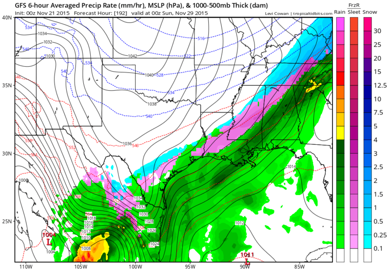
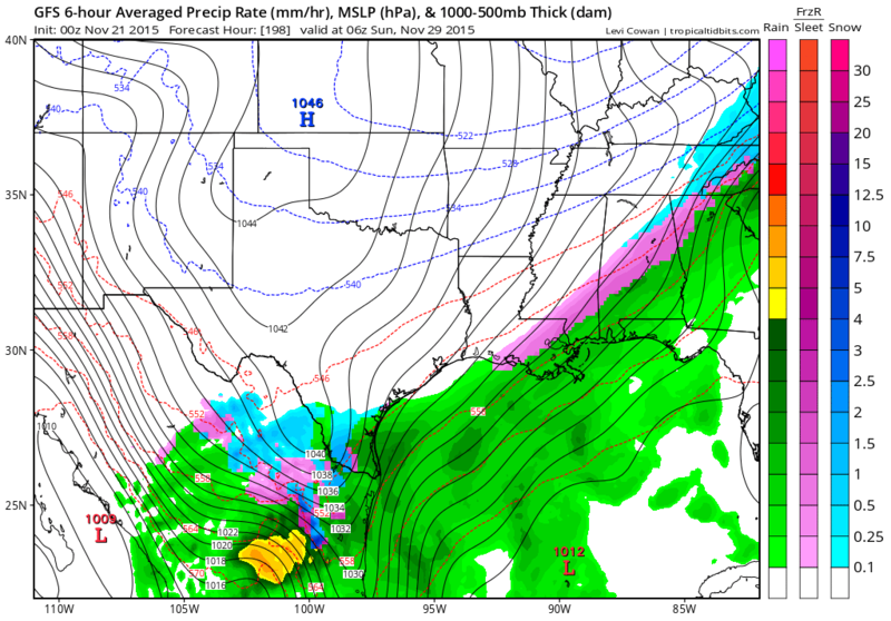
0z GFS is showing super cooled rain then to ice for next Saturday. It is not pushing the time frame back. I would really start considering this as a possibility especially given these shallow air masses often outruns guidance. It also still has the EPAC hurricane beginning to make landfall as moisture streams up from Sandra.
It would be one heck of a weather event from all aspects. Cold, flooding, thunderstorms, ice.
Both the sprawling convection for Sandra (to be) and Arctic air now both exists. It's a matter if they will meet and where.
It would be one heck of a weather event from all aspects. Cold, flooding, thunderstorms, ice.
Both the sprawling convection for Sandra (to be) and Arctic air now both exists. It's a matter if they will meet and where.
0 likes
The above post and any post by Ntxw is NOT an official forecast and should not be used as such. It is just the opinion of the poster and may or may not be backed by sound meteorological data. It is NOT endorsed by any professional institution including Storm2k. For official information, please refer to NWS products.
Help support Storm2K!
Help support Storm2K!
-
Brent
- S2K Supporter
- Posts: 38737
- Age: 37
- Joined: Sun May 16, 2004 10:30 pm
- Location: Tulsa Oklahoma
- Contact:
Re: Texas Fall-2015
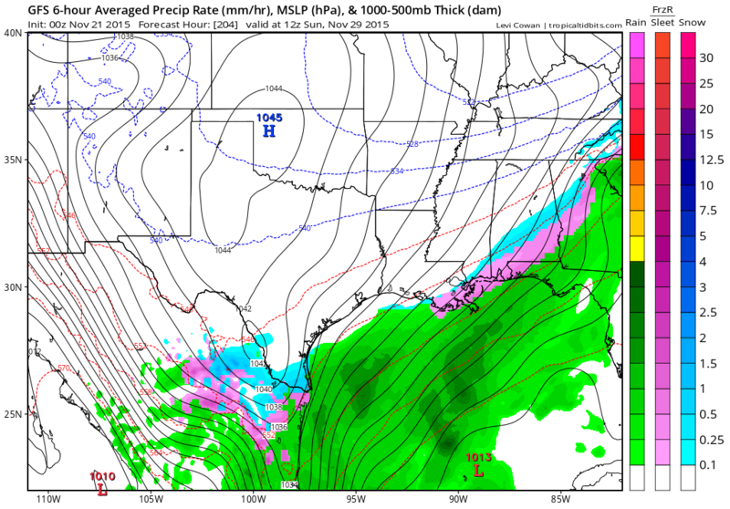
This run doesn't have nearly the precip on Saturday when it's cold enough it appears as the 18z. Just a brief window Friday Night actually, the precip is gone on Saturday morning.
and actually even then temps are above freezing in most of the metro. There is freezing temps just west of the metro though.
But still... highs in the 30s next weekend both days.
and actually even then temps are above freezing in most of the metro. There is freezing temps just west of the metro though.
But still... highs in the 30s next weekend both days.
Last edited by Brent on Fri Nov 20, 2015 11:52 pm, edited 1 time in total.
0 likes
#neversummer
-
TheProfessor

- Professional-Met

- Posts: 3506
- Age: 29
- Joined: Tue Dec 03, 2013 10:56 am
- Location: Wichita, Kansas
Re: Texas Fall-2015
Brent wrote:This run doesn't have nearly the precip on Saturday when it's cold enough it appears as the 18z. Just a brief window Friday Night actually, the precip is gone on Saturday morning.
and actually even then temps are above freezing in most of the metro. There is freezing temps just west of the metro though.
I like this run.
0 likes
An alumnus of The Ohio State University.
Your local National Weather Service office is your best source for weather information.
Your local National Weather Service office is your best source for weather information.
-
TheProfessor
- Professional-Met
- Posts: 3506
- Age: 29
- Joined: Tue Dec 03, 2013 10:56 am
- Location: Wichita, Kansas
-
Brent
- S2K Supporter
- Posts: 38737
- Age: 37
- Joined: Sun May 16, 2004 10:30 pm
- Location: Tulsa Oklahoma
- Contact:
Re:
TheProfessor wrote:Yeah, I don't like the CMC, looks like 42 hours of ice right along the 35 coridoor.
Close call in the metro, might be above freezing barely in the metro, but it also has a 2nd round of precip Saturday whereas the GFS does not:

0 likes
#neversummer
-
Rgv20

- S2K Supporter
- Posts: 2466
- Age: 39
- Joined: Wed Jan 05, 2011 5:42 pm
- Location: Edinburg/McAllen Tx
Definitely like the last 2 runs of the GFS showing some Wintery Precipitation for next weekend in South Texas! 


0 likes
The following post is NOT an official forecast and should not be used as such. It is just the opinion of the poster and may or may not be backed by sound meteorological data. It is NOT endorsed by any professional institution including storm2k.org For Official Information please refer to the NHC and NWS products.

Re: Texas Fall-2015
TheProfessor wrote:Brent wrote:This run doesn't have nearly the precip on Saturday when it's cold enough it appears as the 18z. Just a brief window Friday Night actually, the precip is gone on Saturday morning.
and actually even then temps are above freezing in most of the metro. There is freezing temps just west of the metro though.
I like this run.
C'mon man... You can't go from rooting for winter weather in Texas to suddenly being against it. The rest of us don't get to spend our winter in Ohio. I'm sure your professors will allow you to make up a test if your flight is cancelled because of a winter storm in Texas. Because if what some of the models runs have been showing actually comes to fruition, you won't be the only one who gets stranded after Thanksgiving. So just enjoy it if it happens while you're here. And look at it this way... extra study time.
0 likes
-
Brent
- S2K Supporter
- Posts: 38737
- Age: 37
- Joined: Sun May 16, 2004 10:30 pm
- Location: Tulsa Oklahoma
- Contact:
Re: Texas Fall-2015
The GFS has the next one lined up around 300 hours. 
No boring times in the weather dept... and temps stay quite cold.

No boring times in the weather dept... and temps stay quite cold.
0 likes
#neversummer