Texas Fall-2015

U.S. & Caribbean Weather Discussions and Severe Weather Events

Moderator: S2k Moderators

Forum rules

The posts in this forum are NOT official forecast and should not be used as such. They are just the opinion of the poster and may or may not be backed by sound meteorological data. They are NOT endorsed by any professional institution or STORM2K.

Help Support Storm2K
Message
Author
weatherdude1108
Category 5
Category 5
Posts: 4228
Joined: Tue Dec 13, 2011 1:04 pm
Location: Northwest Austin/Cedar Park, TX

Re:

#2241 Postby weatherdude1108 » Sat Nov 21, 2015 11:53 pm

TheProfessor wrote::uarrow: it's not really the cold that was getting to me, I was here last year when it was 13 degrees and was fine, It was getting wet, There wasn't a way for me to protect my legs and feet. being soaked in 40 degrees weather is worse than being dry when 10 degrees imo.


Yeah. I agree with that. I went to school in Lubbock. It got down to 9 degrees and that was cold, but it was a dry cold. It is the upper 30s to 40s with rain and wind that always gets me to the core, every time. Happens in Houston in a typical Winter. So much worse than dry cold IMO.
:wink:
0 likes   
The preceding post is NOT an official forecast, and should not be used as such. It is only the opinion of the poster and may or may not be backed by sound meteorological data. It is NOT endorsed by any professional institution including storm2k.org. For Official Information please refer to the NHC and NWS products.

Brent
S2K Supporter
S2K Supporter
Posts: 38088
Age: 36
Joined: Sun May 16, 2004 10:30 pm
Location: Tulsa Oklahoma
Contact:

Re: Re:

#2242 Postby Brent » Sun Nov 22, 2015 12:09 am

weatherdude1108 wrote:
TheProfessor wrote::uarrow: it's not really the cold that was getting to me, I was here last year when it was 13 degrees and was fine, It was getting wet, There wasn't a way for me to protect my legs and feet. being soaked in 40 degrees weather is worse than being dry when 10 degrees imo.


Yeah. I agree with that. I went to school in Lubbock. It got down to 9 degrees and that was cold, but it was a dry cold. It is the upper 30s to 40s with rain and wind that always gets me to the core, every time. Happens in Houston in a typical Winter. So much worse than dry cold IMO.
:wink:


Yeah dry cold doesn't bother me as long as it's not windy... I've actually gone out in shorts before and it's not that bad...

the cold rains on the other hand will never be pleasant. :lol:
0 likes   
#neversummer

Brent
S2K Supporter
S2K Supporter
Posts: 38088
Age: 36
Joined: Sun May 16, 2004 10:30 pm
Location: Tulsa Oklahoma
Contact:

Re: Texas Fall-2015

#2243 Postby Brent » Sun Nov 22, 2015 12:44 am

CMC is quite similar to the GFS with the bulk of the frozen precip west of I-35, but it does have some in DFW and Austin, very close call for a bigger event

Image


Image
0 likes   
#neversummer

User avatar
SouthernMet
Category 3
Category 3
Posts: 857
Joined: Sun Aug 29, 2010 8:23 pm
Location: fort worth, tx

Re: Texas Fall-2015

#2244 Postby SouthernMet » Sun Nov 22, 2015 2:08 am

Already 28 degrees at Alliance
0 likes   
Nothing that SouthernMet posts, is an official forecast,nor does it reflect views of STORM2K.. SouthernMet is just adding to the great discussions on STORM2K.. Refer to NWS for official forecasts.

gpsnowman
S2K Supporter
S2K Supporter
Posts: 3185
Joined: Fri Jan 07, 2011 10:35 am
Location: Grand Prairie Tx

#2245 Postby gpsnowman » Sun Nov 22, 2015 5:16 am

Car thermometer read 33 on the way into work this morning. Before leaving I just stood on my driveway to feel the cold air. Felt refreshing and it woke me up a bit. Nothing like being able to watch the sunrise on a crisp fall morning. Enjoy today everyone.
0 likes   

User avatar
Ntxw
Storm2k Moderator
Storm2k Moderator
Posts: 22784
Joined: Wed Oct 21, 2009 6:34 pm
Location: DFW, Texas

#2246 Postby Ntxw » Sun Nov 22, 2015 9:02 am

DFW recorded its first official freeze today.

0z Euro has mid and upper 30s with heavy rain next weekend.
0 likes   
The above post and any post by Ntxw is NOT an official forecast and should not be used as such. It is just the opinion of the poster and may or may not be backed by sound meteorological data. It is NOT endorsed by any professional institution including Storm2k. For official information, please refer to NWS products.

  Help support Storm2K!
Help Support Storm2K

User avatar
hriverajr
Professional-Met
Professional-Met
Posts: 786
Joined: Tue Jul 19, 2005 12:16 am

Re: Texas Fall-2015

#2247 Postby hriverajr » Sun Nov 22, 2015 9:07 am

6z GFS warmer with some fairly heavy rain next weekend. In fact hints at lower coastal low formation. Frozen Precip confined to NW Texas
0 likes   
Anything I post is my personal opinion and should not used for any type of planning or lifesaving reasons. Please refer to National Weather Service forecasts.

User avatar
Portastorm
Storm2k Moderator
Storm2k Moderator
Posts: 9914
Age: 63
Joined: Fri Jul 11, 2003 9:16 am
Location: Round Rock, TX
Contact:

Re: Texas Fall-2015

#2248 Postby Portastorm » Sun Nov 22, 2015 9:15 am

hriverajr wrote:6z GFS warmer with some fairly heavy rain next weekend. In fact hints at lower coastal low formation. Frozen Precip confined to NW Texas


Yeah at this point I think we can all agree that there will be plenty of QPF around late next week. Could even see some flooding issues.
0 likes   
Any forecasts under my name are to be taken with a grain of salt. Get your best forecasts from the National Weather Service and National Hurricane Center.

User avatar
srainhoutx
S2K Supporter
S2K Supporter
Posts: 6919
Age: 67
Joined: Sun Jan 14, 2007 11:34 am
Location: Haywood County, NC
Contact:

Re: Texas Fall-2015

#2249 Postby srainhoutx » Sun Nov 22, 2015 9:20 am

Portastorm wrote:
hriverajr wrote:6z GFS warmer with some fairly heavy rain next weekend. In fact hints at lower coastal low formation. Frozen Precip confined to NW Texas


Yeah at this point I think we can all agree that there will be plenty of QPF around late next week. Could even see some flooding issues.


That would be the most plausible solution with the TC Sandra remnants spreading over a very shallow cold air regime at the surface. As TC Sandra remnants bring its abundant tropical moisture out of Mexico into Texas, carefully watch for a Coastal trough/low to organize across S Texas and progress NE allowing elevated thunderstorm chances to increase Friday through next weekend.
0 likes   
Carla/Alicia/Jerry(In The Eye)/Michelle/Charley/Ivan/Dennis/Katrina/Rita/Wilma/Ike/Harvey

Member: National Weather Association
Wx Infinity Forums
http://wxinfinity.com/index.php

Facebook.com/WeatherInfinity
Twitter @WeatherInfinity

User avatar
TheAustinMan
Category 5
Category 5
Posts: 1047
Age: 25
Joined: Mon Jul 08, 2013 4:26 pm
Location: United States
Contact:

#2250 Postby TheAustinMan » Sun Nov 22, 2015 11:52 am

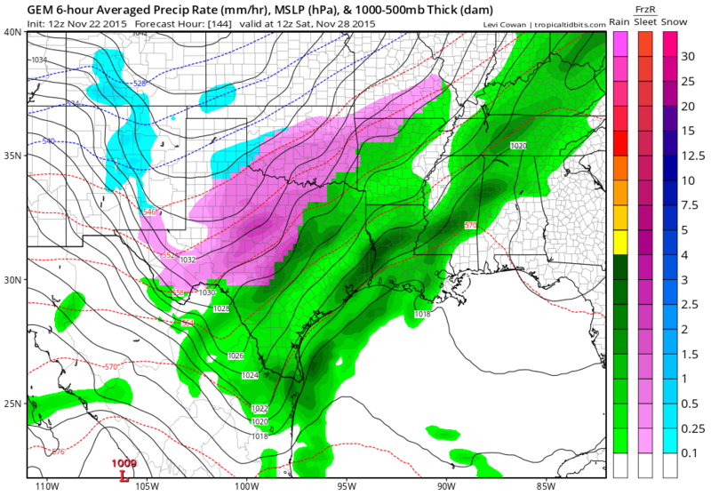
12z GFS run today has now covered the Thanksgiving weekend event, and now indicates only sleet in the Texas Panhandle from Friday-Sunday as the rest of the state remains well above freezing.

Image
Image
0 likes   
ImageImageImage
Treat my opinions with a grain of salt. For official information see your local weather service.

lukem
Tropical Storm
Tropical Storm
Posts: 123
Joined: Wed Feb 17, 2010 2:53 pm

Re: Texas Fall-2015

#2251 Postby lukem » Sun Nov 22, 2015 12:22 pm

What kind of rain totals are we looking at through the weekend? Looks like a good setup for flooding.
0 likes   

User avatar
Rgv20
S2K Supporter
S2K Supporter
Posts: 2466
Age: 38
Joined: Wed Jan 05, 2011 5:42 pm
Location: Edinburg/McAllen Tx

#2252 Postby Rgv20 » Sun Nov 22, 2015 12:23 pm

12zCMC stays consistent with its solution thru next weekend....lets see what the ECMWF shows next.

Image
0 likes   
The following post is NOT an official forecast and should not be used as such. It is just the opinion of the poster and may or may not be backed by sound meteorological data. It is NOT endorsed by any professional institution including storm2k.org For Official Information please refer to the NHC and NWS products.

User avatar
TexasF6
S2K Supporter
S2K Supporter
Posts: 816
Joined: Mon Aug 09, 2004 9:33 pm
Location: Austin, TX

Re: Texas Fall-2015

#2253 Postby TexasF6 » Sun Nov 22, 2015 12:30 pm

If the source region is Siberian in nature, and the snowpack is laid down, as it is, the air could very well be much colder than what the models are showing in these latest runs. -36F crossing the Bering Straits combining with Canadian air coming down the lee side of the Rockies makes for interesting wx into Texas. It "Bears Watching" at this point, IMHO. Bastardi said the models were contradicting themselves, and to use your noggin to see what is wrong with them? Thoughts?
0 likes   
This is not an official forecast, follow the NWS for official products!!!

User avatar
TheProfessor
Professional-Met
Professional-Met
Posts: 3506
Age: 28
Joined: Tue Dec 03, 2013 10:56 am
Location: Wichita, Kansas

#2254 Postby TheProfessor » Sun Nov 22, 2015 12:57 pm

I don't like the 12z GFS as it has Precip lasting longer, even though it's rain, we've seen the models handle shallow cold air very poorly.

Edit: and If the 12z CMC is misjudging the cold I could be stuck in Texas for a long while, the Tuesday event is borderline, but if there is ice on the ground from then it would likely be colder for Tuesday, then it has the storm hitting Ohio afterwards. :(
0 likes   
An alumnus of The Ohio State University.

Your local National Weather Service office is your best source for weather information.

GRAYSONCO.WX
Category 1
Category 1
Posts: 450
Joined: Thu Jan 06, 2011 4:29 pm
Location: Denison, Texas

Re:

#2255 Postby GRAYSONCO.WX » Sun Nov 22, 2015 1:13 pm

TheProfessor wrote:I don't like the 12z GFS as it has Precip lasting longer, even though it's rain, we've seen the models handle shallow cold air very poorly.

Edit: and If the 12z CMC is misjudging the cold I could be stuck in Texas for a long while, the Tuesday event is borderline, but if there is ice on the ground from then it would likely be colder for Tuesday, then it has the storm hitting Ohio afterwards. :(


Don't come home for Thanksgiving, then. It's as simple as that..
0 likes   

User avatar
TheProfessor
Professional-Met
Professional-Met
Posts: 3506
Age: 28
Joined: Tue Dec 03, 2013 10:56 am
Location: Wichita, Kansas

Re: Re:

#2256 Postby TheProfessor » Sun Nov 22, 2015 1:20 pm

GRAYSONCO.WX wrote:
TheProfessor wrote:I don't like the 12z GFS as it has Precip lasting longer, even though it's rain, we've seen the models handle shallow cold air very poorly.

Edit: and If the 12z CMC is misjudging the cold I could be stuck in Texas for a long while, the Tuesday event is borderline, but if there is ice on the ground from then it would likely be colder for Tuesday, then it has the storm hitting Ohio afterwards. :(


Don't come home for Thanksgiving, then. It's as simple as that..


Idk if you are joking, but I will say seeing my Grandmother (who I only see twice a year) is worth getting stuck.
0 likes   
An alumnus of The Ohio State University.

Your local National Weather Service office is your best source for weather information.

User avatar
hriverajr
Professional-Met
Professional-Met
Posts: 786
Joined: Tue Jul 19, 2005 12:16 am

Re: Texas Fall-2015

#2257 Postby hriverajr » Sun Nov 22, 2015 1:33 pm

The 12z looks a little warm to me

Oh yeah, quit picking on the young man.
0 likes   
Anything I post is my personal opinion and should not used for any type of planning or lifesaving reasons. Please refer to National Weather Service forecasts.

Ralph's Weather
S2K Supporter
S2K Supporter
Posts: 3269
Age: 38
Joined: Fri Dec 13, 2013 11:55 am
Location: Lindale, TX
Contact:

Re: Texas Fall-2015

#2258 Postby Ralph's Weather » Sun Nov 22, 2015 2:34 pm

hriverajr wrote:The 12z looks a little warm to me

Oh yeah, quit picking on the young man.

I agree that recent runs look too warm. Maybe the heavy rain brings down too much warm air, but temps near 40 seem awful warm. I have not been able to study the models this weekend so not sure how far north they are holding the deeper cold.
0 likes   
Follow on Facebook at Ralph's Weather.

User avatar
1900hurricane
Category 5
Category 5
Posts: 6059
Age: 34
Joined: Fri Feb 06, 2015 12:04 pm
Location: Houston, TX
Contact:

#2259 Postby 1900hurricane » Sun Nov 22, 2015 4:05 pm

Recent model runs look ok to me. The trends with the upper level troughing have been with it hanging up considerably more, which would give much less push to the cold airmass. Couple that with warm tropical air with sources from both the Atlantic and the Pacific overrunning the colder airmass, the airmass will likely modify considerably.
0 likes   
Contract Meteorologist. TAMU & MSST. Fiercely authentic, one of a kind. We are all given free will, so choose a life meant to be lived. We are the Masters of our own Stories.
Opinions expressed are mine alone.

Follow me on Twitter at @1900hurricane : Read blogs at https://1900hurricane.wordpress.com/

User avatar
Ntxw
Storm2k Moderator
Storm2k Moderator
Posts: 22784
Joined: Wed Oct 21, 2009 6:34 pm
Location: DFW, Texas

Re: Texas Fall-2015

#2260 Postby Ntxw » Sun Nov 22, 2015 7:16 pm

lukem wrote:What kind of rain totals are we looking at through the weekend? Looks like a good setup for flooding.


Widespread 2-4", some areas receiving 4-6"

Image

For November it's quite anomalous relative to average vs per say October. If these totals verified areas such as DFW would threaten top 10 wettest Novembers and break the yearly record by several inches.
0 likes   
The above post and any post by Ntxw is NOT an official forecast and should not be used as such. It is just the opinion of the poster and may or may not be backed by sound meteorological data. It is NOT endorsed by any professional institution including Storm2k. For official information, please refer to NWS products.


  Help support Storm2K!

Help Support Storm2K


Return to “USA & Caribbean Weather”

Who is online

Users browsing this forum: No registered users and 14 guests