Texas Winter 2015-2016

Winter Weather Discussion

Moderator: S2k Moderators

Forum rules

The posts in this forum are NOT official forecast and should not be used as such. They are just the opinion of the poster and may or may not be backed by sound meteorological data. They are NOT endorsed by any professional institution or STORM2K.

Help Support Storm2K
Message
Author
User avatar
srainhoutx
S2K Supporter
S2K Supporter
Posts: 6919
Age: 67
Joined: Sun Jan 14, 2007 11:34 am
Location: Haywood County, NC
Contact:

Re: Texas Winter 2015-2016

#621 Postby srainhoutx » Tue Dec 22, 2015 9:31 am

The morning forecast challenge will focus on Christmas Day into early next week as a powerful Winter Storm system currently moving across the Gulf of Alaska drops SE into the developing Western Trough and cuts off from the main Polar jet stream across Southern Arizona/Northern Mexico and deepens into a very cold core upper low as very chilly spills South from the Canadian Prairies into the Great Basin/Upper Rio Grande Valley of New Mexico and eventually spills East over the Continental Divide into the Plains during the upcoming weekend. Leeside cyclogenesis, or a strong surface low pressure system is expected to develop across West Texas and slowly move ENE and then NE into the Ozarks as a very strong blocking SE Ridge of High Pressure prevents any storm system of being progressive, or quickly moving East across the Lower 48. That blocking SE Ridge will keep the Eastern 1/3rd of the United States very warm, but trouble lurks across our Region into the Southern/Central Plains as well as the Southern/Central Rockies as folks head home from the busy Christmas Holiday travel period. There is still some uncertainty to the eventual track of the cut off cold core low, but past experience in years that have had a strong El Nino tend to suggest that a more slow meandering Southern track across Mexico to Texas South of the Big Bend and on East into the Permian Basin would be the most likely solution. That eventual storm track will likely not be realized until Christmas Day as the shortwave and the dynamics associated with the cold air currently over Greenland spill SW into the Canadian Prairies and all features enter the RAOB network for ingestion into the computer schemes.

As of this morning will go with a powerful Winter Storm and possible Blizzard condition across New Mexico, Colorado, portions of West Texas into the Panhandle where wind blown snow likely will approach or exceed 2 feet. Depending on the eventual storm track, locations across portions of Oklahoma into portions of Kansas on North may well experience very heavy wind blown snow with the potential of Blizzard conditions across portion of the Southern and Central Plains.

In the warm sector ahead of this developing Storm, a stalled frontal boundary will lift slowly North as a strong low level jet off the Gulf develops in response to rapid pressure falls across Northern Mexico, New Mexico and West Texas ahead of the cold core upper low and developing deep surface low. While there may be a chance for strong to severe storms across Central, N Central, SE and East Texas this coming weekend, too much uncertainty in the low track and just how quickly the storm race SE along a very strong cold front associated with the surface low lends to a VERY uncertain forecast challenge.

Looking ahead into next week in the wake of this power storm, a generally deep Western trough appears to be carved out across the Western 2/3rd of the United States with a continuation of an active storm track as well as a very active sub tropical jet stream over Texas. Stay Tuned as the next 10 days unfold in what could be one of the most challenging forecast period we have seen in a long time.

Image
Last edited by srainhoutx on Tue Dec 22, 2015 9:51 am, edited 1 time in total.
0 likes   
Carla/Alicia/Jerry(In The Eye)/Michelle/Charley/Ivan/Dennis/Katrina/Rita/Wilma/Ike/Harvey

Member: National Weather Association
Wx Infinity Forums
http://wxinfinity.com/index.php

Facebook.com/WeatherInfinity
Twitter @WeatherInfinity

Yukon Cornelius
S2K Supporter
S2K Supporter
Posts: 1798
Age: 41
Joined: Thu Dec 20, 2012 9:23 pm
Location: Dean, TX/Westcliffe, CO

Re: Texas Winter 2015-2016

#622 Postby Yukon Cornelius » Tue Dec 22, 2015 9:40 am

My area had snow last year right after Christmas, I think the 27th. It would be nice to have a repeat this year. So many different variable in play to really know until it pretty much happens I guess.
0 likes   
#neversummer

Ralph's Weather
S2K Supporter
S2K Supporter
Posts: 3269
Age: 38
Joined: Fri Dec 13, 2013 11:55 am
Location: Lindale, TX
Contact:

#623 Postby Ralph's Weather » Tue Dec 22, 2015 9:41 am

Great post srainhoutx. It will surely be an interesting few days of forecasting. This does seem like a situation where past experience trumps models.
0 likes   
Follow on Facebook at Ralph's Weather.

User avatar
ThunderSleetDreams
S2K Supporter
S2K Supporter
Posts: 1477
Age: 43
Joined: Tue Dec 20, 2011 4:42 pm
Location: S of Weimar, TX

Re: Texas Winter 2015-2016

#624 Postby ThunderSleetDreams » Tue Dec 22, 2015 10:07 am

I see some ridging into NW Canada at HR 240 on the Euro. I'd prefer it to set up West of there over Alaska.
0 likes   
#NeverSummer

I hibernate when it gets above 75 degrees!

User avatar
wxman57
Moderator-Pro Met
Moderator-Pro Met
Posts: 22979
Age: 67
Joined: Sat Jun 21, 2003 8:06 pm
Location: Houston, TX (southwest)

Re: Texas Winter 2015-2016

#625 Postby wxman57 » Tue Dec 22, 2015 10:11 am

Looks like the GFS attached rockets to the upper low Saturday night, accelerating it NE at unbelievable speeds. I'd stick with the Euro on this one. Slower movement, heavy snow in the Panhandle and eastern NM. Slight chance for some snow associated with the core of the upper low as it passes just west of D-FW Monday morning.
0 likes   

User avatar
Ntxw
Storm2k Moderator
Storm2k Moderator
Posts: 22785
Joined: Wed Oct 21, 2009 6:34 pm
Location: DFW, Texas

#626 Postby Ntxw » Tue Dec 22, 2015 10:25 am

Maenwhile nearly historic warmth for the east, especially northeast, US. 12-13F departures rising as early winter heat waves goes on there. Many records in NYC will be jeopardy. Monthly warmest, daily warmest, warmest low, most 60+ readings, snowless, and so on to come around Christmas....

Hard to fathom they will beat their warmest December on record by a huge gap. This is their equivalent to a summer 2011 for us in winter. It just blows all other warm Decembers away, most monthly records fall within a few tenths of a degree from each other...this is many many degrees Fahrenheit over. They just recently had warmest September and November on record.
0 likes   
The above post and any post by Ntxw is NOT an official forecast and should not be used as such. It is just the opinion of the poster and may or may not be backed by sound meteorological data. It is NOT endorsed by any professional institution including Storm2k. For official information, please refer to NWS products.

  Help support Storm2K!
Help Support Storm2K

User avatar
wxman57
Moderator-Pro Met
Moderator-Pro Met
Posts: 22979
Age: 67
Joined: Sat Jun 21, 2003 8:06 pm
Location: Houston, TX (southwest)

Re:

#627 Postby wxman57 » Tue Dec 22, 2015 11:12 am

Ntxw wrote:Meanwhile nearly historic warmth for the east, especially northeast, US. 12-13F departures rising as early winter heat waves goes on there. Many records in NYC will be jeopardy. Monthly warmest, daily warmest, warmest low, most 60+ readings, snowless, and so on to come around Christmas....

Hard to fathom they will beat their warmest December on record by a huge gap. This is their equivalent to a summer 2011 for us in winter. It just blows all other warm Decembers away, most monthly records fall within a few tenths of a degree from each other...this is many many degrees Fahrenheit over. They just recently had warmest September and November on record.


I'm starting to tear-up. :crying:

Seriously, I'm not seeing any sign of a pattern change over the next couple of weeks. Don't even look at the GFS beyond 4-5 days. The Euro has been killing it (verification-wise). See the image Ryan Maue posted recently showing GFS vx. Euro verification.

Image
0 likes   

Ralph's Weather
S2K Supporter
S2K Supporter
Posts: 3269
Age: 38
Joined: Fri Dec 13, 2013 11:55 am
Location: Lindale, TX
Contact:

Re: Re:

#628 Postby Ralph's Weather » Tue Dec 22, 2015 11:22 am

wxman57 wrote:
Ntxw wrote:Meanwhile nearly historic warmth for the east, especially northeast, US. 12-13F departures rising as early winter heat waves goes on there. Many records in NYC will be jeopardy. Monthly warmest, daily warmest, warmest low, most 60+ readings, snowless, and so on to come around Christmas....

Hard to fathom they will beat their warmest December on record by a huge gap. This is their equivalent to a summer 2011 for us in winter. It just blows all other warm Decembers away, most monthly records fall within a few tenths of a degree from each other...this is many many degrees Fahrenheit over. They just recently had warmest September and November on record.


I'm starting to tear-up. :crying:

Seriously, I'm not seeing any sign of a pattern change over the next couple of weeks. Don't even look at the GFS beyond 4-5 days. The Euro has been killing it (verification-wise). See the image Ryan Maue posted recently showing GFS vx. Euro verification.

I knew the GFS was struggling, but did not realize how consitently the Euro has been beating it. I think it is very likely that the GFS is far too quick with the northeast turn question is how far east it will come. If it makes it over DFW then most of the N/2 of the state will see below freezing at 850 by Monday. Then what moisture could still be available.
0 likes   
Follow on Facebook at Ralph's Weather.

User avatar
gatorcane
S2K Supporter
S2K Supporter
Posts: 23691
Age: 47
Joined: Sun Mar 13, 2005 3:54 pm
Location: Boca Raton, FL

Re: Texas Winter 2015-2016

#629 Postby gatorcane » Tue Dec 22, 2015 11:30 am

wxman57 wrote:Looks like the GFS attached rockets to the upper low Saturday night, accelerating it NE at unbelievable speeds. I'd stick with the Euro on this one. Slower movement, heavy snow in the Panhandle and eastern NM. Slight chance for some snow associated with the core of the upper low as it passes just west of D-FW Monday morning.


The Euro seems to be showing the same track and intensity for this low for the past several runs now. So, the Euro has latched onto a solution and once it does it usually nails the forecast in this timeframe. Boy has the GFS been so inconsistent!

Interesting comparison between the GFS and Euro above, thanks for sharing that chart.
0 likes   

User avatar
srainhoutx
S2K Supporter
S2K Supporter
Posts: 6919
Age: 67
Joined: Sun Jan 14, 2007 11:34 am
Location: Haywood County, NC
Contact:

Re: Re:

#630 Postby srainhoutx » Tue Dec 22, 2015 11:35 am

wxman57 wrote:
I'm starting to tear-up. :crying:

Seriously, I'm not seeing any sign of a pattern change over the next couple of weeks. Don't even look at the GFS beyond 4-5 days. The Euro has been killing it (verification-wise). See the image Ryan Maue posted recently showing GFS vx. Euro verification.

https://pbs.twimg.com/media/CWzmVzPUYAAOCRO.png


I agree that the GFS has been terrible. I also agree that the next couple of weeks look like more of the same...then the Euro hints of a change right around the time you've called for wintry mischief possibly entering the picture for mid January.

Image
0 likes   
Carla/Alicia/Jerry(In The Eye)/Michelle/Charley/Ivan/Dennis/Katrina/Rita/Wilma/Ike/Harvey

Member: National Weather Association
Wx Infinity Forums
http://wxinfinity.com/index.php

Facebook.com/WeatherInfinity
Twitter @WeatherInfinity

User avatar
TeamPlayersBlue
Category 5
Category 5
Posts: 3445
Joined: Tue Feb 02, 2010 1:44 am
Location: Denver/Applewood, CO

#631 Postby TeamPlayersBlue » Tue Dec 22, 2015 11:49 am

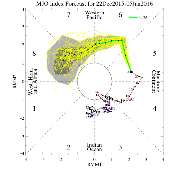
Srain just read my mind. Was going to mention that the MJO isnt in our favor right now either and for the 'turn' to happen, it needs to be more in our favor. Looking at the latest forecast, it seems to be happening. That HP off the Florida coast needs to crack for the turn to happen.
0 likes   
Personal Forecast Disclaimer:
The posts in this forum are NOT official forecast and should not be used as such. They are just the opinion of the poster and may or may not be backed by sound meteorological data. They are NOT endorsed by any professional institution or storm2k.org. For official information, please refer to the NHC and NWS products.

User avatar
wxman57
Moderator-Pro Met
Moderator-Pro Met
Posts: 22979
Age: 67
Joined: Sat Jun 21, 2003 8:06 pm
Location: Houston, TX (southwest)

Re: Texas Winter 2015-2016

#632 Postby wxman57 » Tue Dec 22, 2015 12:28 pm

12Z GFS is not believable. Moves upper low WAY too fast this weekend.
0 likes   

User avatar
gatorcane
S2K Supporter
S2K Supporter
Posts: 23691
Age: 47
Joined: Sun Mar 13, 2005 3:54 pm
Location: Boca Raton, FL

#633 Postby gatorcane » Tue Dec 22, 2015 12:36 pm

Wxman I noticed the 12Z CMC is almost as fast as the GFS for this low and significantly slower then the ECMWF. Thoughts?
0 likes   

Brent
S2K Supporter
S2K Supporter
Posts: 38090
Age: 36
Joined: Sun May 16, 2004 10:30 pm
Location: Tulsa Oklahoma
Contact:

Re: Texas Winter 2015-2016

#634 Postby Brent » Tue Dec 22, 2015 12:52 pm

12z CMC, not gonna do it and much faster than the Euro:

Image

Image
0 likes   
#neversummer

Ralph's Weather
S2K Supporter
S2K Supporter
Posts: 3269
Age: 38
Joined: Fri Dec 13, 2013 11:55 am
Location: Lindale, TX
Contact:

#635 Postby Ralph's Weather » Tue Dec 22, 2015 12:58 pm

12Z GFS track is getting closer, but it is still too fast. The 0Z Euro bring the low over N TX on Monday and the 12Z GEM takes the classic C TX to AR track on Monday. Take the GEM track and just a tad colder and N and NE TX get much more interesting.
12Z GFS Ensembles starting to show some hints of snow into N TX and some individuals slowing it down and staying further south.
0 likes   
Follow on Facebook at Ralph's Weather.

User avatar
wxman57
Moderator-Pro Met
Moderator-Pro Met
Posts: 22979
Age: 67
Joined: Sat Jun 21, 2003 8:06 pm
Location: Houston, TX (southwest)

Re: Texas Winter 2015-2016

#636 Postby wxman57 » Tue Dec 22, 2015 1:56 pm

12Z Euro is much faster with the upper low movement than the 00Z. For example, the GFS had the upper low west of Chicago on Monday while the 00Z Euro had it west of Dallas. The 12Z Euro now has the low over northern Missouri vs. west of Dallas on Monday afternoon. Big change. It still has the snow confined to the TX Panhandle, where upward of 2ft of snow is predicated to fall from Amarillo to the OK Panhandle.
0 likes   

Ralph's Weather
S2K Supporter
S2K Supporter
Posts: 3269
Age: 38
Joined: Fri Dec 13, 2013 11:55 am
Location: Lindale, TX
Contact:

#637 Postby Ralph's Weather » Tue Dec 22, 2015 1:59 pm

Models still all over the place. thought the Euro would hold out, but nope it is ejecting the low much faster almost like the GFS. 12Z GEM still in the slow camp.
One GFS individual has no snow in NW TX and 7-10" in E TX :lol:
0 likes   
Follow on Facebook at Ralph's Weather.

User avatar
srainhoutx
S2K Supporter
S2K Supporter
Posts: 6919
Age: 67
Joined: Sun Jan 14, 2007 11:34 am
Location: Haywood County, NC
Contact:

Re: Texas Winter 2015-2016

#638 Postby srainhoutx » Tue Dec 22, 2015 2:06 pm

Poof goes those 70's for New Years Day in SE Texas via the Euro as well.
0 likes   
Carla/Alicia/Jerry(In The Eye)/Michelle/Charley/Ivan/Dennis/Katrina/Rita/Wilma/Ike/Harvey

Member: National Weather Association
Wx Infinity Forums
http://wxinfinity.com/index.php

Facebook.com/WeatherInfinity
Twitter @WeatherInfinity

Snowman67
Category 2
Category 2
Posts: 633
Joined: Thu Dec 31, 2009 12:44 pm
Location: Tomball, TX

Re: Texas Winter 2015-2016

#639 Postby Snowman67 » Tue Dec 22, 2015 2:22 pm

srainhoutx wrote:Poof goes those 70's for New Years Day in SE Texas via the Euro as well.


What is it showing now? Thanks.
0 likes   
Any forecast I make is based on my opinion only. Please refer to the NWS or NHC for official forecasts.

User avatar
wxman57
Moderator-Pro Met
Moderator-Pro Met
Posts: 22979
Age: 67
Joined: Sat Jun 21, 2003 8:06 pm
Location: Houston, TX (southwest)

Re: Texas Winter 2015-2016

#640 Postby wxman57 » Tue Dec 22, 2015 2:38 pm

Snowman67 wrote:
srainhoutx wrote:Poof goes those 70's for New Years Day in SE Texas via the Euro as well.


What is it showing now? Thanks.


It only goes out to 6am on New Year's Day, but it's forecasting a low in the upper 30s to near 40. High probably in the upper 50s to 60.
0 likes   


Return to “Winter Weather”

Who is online

Users browsing this forum: No registered users and 17 guests