18Z NAM at 84 hours (Saturday night) is significantly further south than GFS having the low completely in N Mexico instead of on the border.
12Z GFS and Euro have the low over N TX with the GFS slightly faster and maybe a tad stronger. The main difference between the two is the GFS has the surface low on the NE side while the Euro has it on the NW side of the upper low. Saturday night the upper low is over S AZ on both.
12Z GEM Sunday night is over C TX and is a bit weaker with the upper low and has the surface low on the NE side. Also it had the low over N Mexico Saturday night.
Take a blend of all of that and assume a bit colder surface being Arctic air plus cold aloft and you get a upper low tracking from Big Bend to Waco to Texarkana at around 540dm and a sub 1000 mb surface low tracking just ahead of it.
18Z GFS taking the GEM path now. It has 1-2" of liquid precip on the cold side and 2-5" on the warm side. Shows the freezing line struggling to get into DFW though. So take what I said above as this track is pretty much a blend of the 12Z suite and assume colder surface and that could be a biggie for N TX.
Texas Winter 2015-2016
Moderator: S2k Moderators
Forum rules
 The posts in this forum are NOT official forecast and should not be used as such. They are just the opinion of the poster and may or may not be backed by sound meteorological data. They are NOT endorsed by any professional institution or STORM2K.

The posts in this forum are NOT official forecast and should not be used as such. They are just the opinion of the poster and may or may not be backed by sound meteorological data. They are NOT endorsed by any professional institution or STORM2K.
-
Ralph's Weather
- S2K Supporter

- Posts: 3374
- Age: 38
- Joined: Fri Dec 13, 2013 11:55 am
- Location: Lindale, TX
- Contact:
Last edited by Ralph's Weather on Wed Dec 23, 2015 5:22 pm, edited 1 time in total.
0 likes
Follow on Facebook at Ralph's Weather.

-
Ralph's Weather
- S2K Supporter
- Posts: 3374
- Age: 38
- Joined: Fri Dec 13, 2013 11:55 am
- Location: Lindale, TX
- Contact:
Re:
texas1836 wrote:Is this storm similar to Nuri in power?
These are very different type storms. Nuri bombed out west of Alaska and caused the jet to buckle downstream releasing Arctic air down the Plains. This storm is crossing the North Pacific as a average low pressure swirl, but it will itself dig down into Mexico before turning east then northeast over Texas around the SE upper level ridge.
0 likes
Follow on Facebook at Ralph's Weather.
-
TheProfessor

- Professional-Met

- Posts: 3506
- Age: 29
- Joined: Tue Dec 03, 2013 10:56 am
- Location: Wichita, Kansas
-
Ralph's Weather
- S2K Supporter
- Posts: 3374
- Age: 38
- Joined: Fri Dec 13, 2013 11:55 am
- Location: Lindale, TX
- Contact:
Re:
TheProfessor wrote:Is the Westward Jump on the GFS Realistic?
It is in line with the GEM (take that for what it is worth), the recent trend of further south and slower and it follows other classic storm's paths. Plus we all hope that it is true.
0 likes
Follow on Facebook at Ralph's Weather.
-
TheProfessor
- Professional-Met
- Posts: 3506
- Age: 29
- Joined: Tue Dec 03, 2013 10:56 am
- Location: Wichita, Kansas
Re: Re:
Ralph's Weather wrote:TheProfessor wrote:Is the Westward Jump on the GFS Realistic?
It is in line with the GEM (take that for what it is worth), the recent trend of further south and slower and it follows other classic storm's paths. Plus we all hope that it is true.
No I mean it moves further east on the run but then it takes a westward jog before it moves north/northeast. That would hurt DFWs chances for snow. I've never seen non tropical low pressures do huge jogs like that, is the high pressure extended there?
0 likes
An alumnus of The Ohio State University.
Your local National Weather Service office is your best source for weather information.
Your local National Weather Service office is your best source for weather information.
-
Ralph's Weather
- S2K Supporter
- Posts: 3374
- Age: 38
- Joined: Fri Dec 13, 2013 11:55 am
- Location: Lindale, TX
- Contact:
Re: Re:
TheProfessor wrote:Ralph's Weather wrote:TheProfessor wrote:Is the Westward Jump on the GFS Realistic?
It is in line with the GEM (take that for what it is worth), the recent trend of further south and slower and it follows other classic storm's paths. Plus we all hope that it is true.
No I mean it moves further east on the run but then it takes a westward jog before it moves north/northeast. That would hurt DFWs chances for snow. I've never seen non tropical low pressures do huge jogs like that, is the high pressure extended there?
Hmm,I did not catch that. Seems unlikely.
0 likes
Follow on Facebook at Ralph's Weather.
-
SouthernMet

- Category 3

- Posts: 857
- Joined: Sun Aug 29, 2010 8:23 pm
- Location: fort worth, tx
Re: Texas Winter 2015-2016
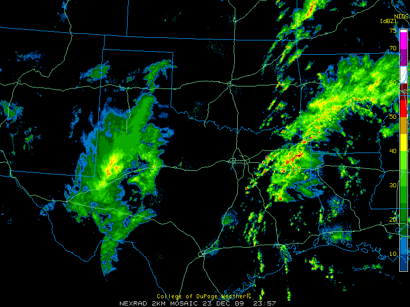
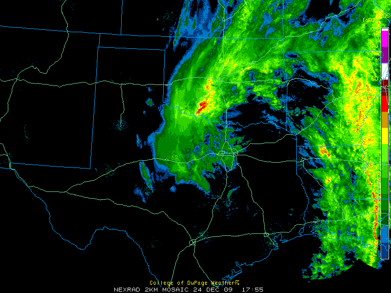
Christmas Eve 09 Vs GFS


0 likes
Nothing that SouthernMet posts, is an official forecast,nor does it reflect views of STORM2K.. SouthernMet is just adding to the great discussions on STORM2K.. Refer to NWS for official forecasts.

Don't forget there is a flooding threat too especially north and northeast Texas before any flakes fly. 4-8" and locally more in areas that simply cannot hold much more. This much rain in the winter season is very anomalous for it is second dry season of the year.
0 likes
The above post and any post by Ntxw is NOT an official forecast and should not be used as such. It is just the opinion of the poster and may or may not be backed by sound meteorological data. It is NOT endorsed by any professional institution including Storm2k. For official information, please refer to NWS products.
Help support Storm2K!
-
Ralph's Weather
- S2K Supporter
- Posts: 3374
- Age: 38
- Joined: Fri Dec 13, 2013 11:55 am
- Location: Lindale, TX
- Contact:
SouthernMet great set of images. This does look like a repeat, but more moisture this time it appears.
0 likes
Follow on Facebook at Ralph's Weather.
-
SouthernMet
- Category 3
- Posts: 857
- Joined: Sun Aug 29, 2010 8:23 pm
- Location: fort worth, tx
Re: Texas Winter 2015-2016
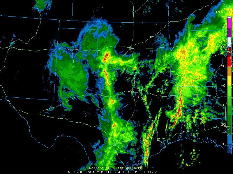
Christmas Eve 09 Vs CMC


0 likes
Nothing that SouthernMet posts, is an official forecast,nor does it reflect views of STORM2K.. SouthernMet is just adding to the great discussions on STORM2K.. Refer to NWS for official forecasts.
-
TheProfessor
- Professional-Met
- Posts: 3506
- Age: 29
- Joined: Tue Dec 03, 2013 10:56 am
- Location: Wichita, Kansas
-
vbhoutex

- Storm2k Executive

- Posts: 29149
- Age: 74
- Joined: Wed Oct 09, 2002 11:31 pm
- Location: Cypress, TX
- Contact:
Re: Texas Winter 2015-2016
This is Jeff Lindner's take on the next 5 days of weather:
Highly active “spring like” weather pattern will bring severe weather and flooding rainfall to the southern US over the next 5 days.
Many locations will set record high temperatures on Christmas Eve and Christmas Day east of the Rockies.
Today:
Strong upper level storm system moving over the central plains this morning is pushing a weak cool front across SE TX currently. Temperatures ahead of this boundary under clearing skies are soaring into the lower 80’s and it looks like we will be approaching record values this afternoon. Most low level moisture is being scoured out to our east currently allowing the clearing skies and satellite images and coastal cameras show the dense sea fog bank as broken up for the time being.
A very significant tornado outbreak is underway over the lower MS valley and will continue into the evening hours with multiple long tracked violent tornadoes possible especially over N MS into W TN. This is a climo favored tornado setup for late December in the mid South and such outbreaks can result in high fatality rates especially after dark in this area of the country. Given breaks in the overcast over NE LA into N MS and N AL over the last few hours…expect significant supercell development within the next 1-2 hours with resulting damaging tornadoes across that region.
Christmas Eve:
Weak boundary stalls near the coast tonight and high resolution models show a sea fog bank forming over the coastal waters south of Lake Charles and Sabine Pass late tonight and moving westward early Thursday morning. Sea fog bank should arrive into the upper TX coast by 200-600am and spread inland during the early morning hours. This would be along and south of a returning warm front which will bring a very warm and muggy air mass northward across SE TX on Thursday. Meso models show shower breaking out under this returning moisture by midday and continuing into the evening hours. Increasing clouds and possible rain showers may help keep temperatures from getting to out of hand on Thursday…but any breaks in the cloud cover will result in 80 degree readings which are nearing records for the date.
Christmas Day:
Short wave will ripple across the area in the SW upper air flow aloft as a powerful storm system digs into the SW US. Will need to key in on Christmas morning for a period of potential shower and thunderstorms. Increasing low level jet and firmly entrenched high moist air mass does support a low end severe weather threat east of a line from College Station to Galveston. Any isolated severe weather should be short lived and contained to the morning hours. Periods of showers and thunderstorms will then move inland from the Gulf of Mexico through the day and into Christmas night as warm air advection and the low level jet increases. Temperatures will be in the muggy 70’s to near 80 during the day with lows near 70. Currently looking like 2015 will go down as one of the top 10 warmest Christmas Days on record and could even be in the top 5. Record high for Dec 25 is 82 for IAH
Weekend:
Powerful storm system will move across TX with severe weather and heavy rainfall
Deepening upper level trough digging into the SW US late this week will dig even further southward into N MX by late Friday into Saturday. Surface low pressure will develop under the strong upper level jet forcing over SW TX early Saturday and move ENE to NE across the state. Warm sector air mass east of I-35 becoming increasing unstable during the day and with large scale lift increasing expect widespread showers and thunderstorms to stream northward across the area. Wind shear values increase with time as the upper jet cores into the region by Saturday afternoon. Will have to watch for discrete cells over the area Saturday afternoon which could pose a tornado threat. We have seen this setup a few times this fall, but only two events have actually produced tornadoes (Halloween and December 12).
Upper trough takes a negative tilt orientation as it ejects into TX late Saturday with strong jet dynamics overspreading the warm sector. Strong Canadian cold front will surge down the plains and across TX Saturday night slicing into this primed air mass. Expect a fairly extensive squall line to develop and cross the region Saturday night into Sunday with all severe weather modes possible. PWS soar to nearly 2.0 inches which would be record values (sound familiar) for this time of year and this would certainly support a widespread heavy rainfall threat. With so much warmth and humidity in place in the downstream air mass combined with the strong dynamics of winter storm systems…it is going to be a very active period across the southern plains and southern US this weekend. SPC has 15% probabilities for severe weather days 4/5 (Sat/Sun) over central and eastern TX and this system will certainly support a category “enhanced” and “slight” risk outlines by Day 3 (tomorrow) for portions of the outline area.
Large scale blizzard will develop on the backside of the upper level trough over NW TX and into NW OK Sunday with significant accumulation of snowfall expected.
Cold air will crash through SE TX Sunday with temperatures in the 70’s falling rapidly into the 40’s. Highs next Monday look locked in the 40’s under gusty north winds and clouds…as winter returns to the region.
Hydro:
Grounds remain saturated from the recent rainfall and many rivers are either in flood or well above base flow especially across the eastern portions of TX. Widespread rainfall amounts this weekend of 2-3 inches and isolated totals upwards of 6-8 inches especially over N TX will only result in additional river flooding. Area reservoirs and lakes continue to attempt to evacuate their flood pools and drawn down their conservation pools to build as much capacity into storage ahead of this storm system…but flooding is almost going to certainly result on rivers that are already near or over capacity (Trinity, Navasota, Neches, Sabine).
0 likes
Skywarn, C.E.R.T.
Please click below to donate to STORM2K to help with the expenses of keeping the site going:

Please click below to donate to STORM2K to help with the expenses of keeping the site going:
Re: Re:
Ralph's Weather wrote:texas1836 wrote:Is this storm similar to Nuri in power?
These are very different type storms. Nuri bombed out west of Alaska and caused the jet to buckle downstream releasing Arctic air down the Plains. This storm is crossing the North Pacific as a average low pressure swirl, but it will itself dig down into Mexico before turning east then northeast over Texas around the SE upper level ridge.
Yeah not the same animal. But this storm for our region is about as tough and strong as they get. You don't see 50mph+ blizzards very often in the southern plains. It has direct flow from Alaska feeding into it while rich Gulf/Caribbean moisture from the south as well as the Pacific jets. Just perfect combo. Dec 09, Superbowl week type stuff.
I'm willing to bet money cold air will drive faster than they anticipate. GFS has below zero temps in the northern plains before the storm kicks out. 1047mb high up north with a deep ULL spells temp busts. The gradient between the two is just spectacular. Very high winds. I suspect high wind warnings will be hoisted this weekend for many.
0 likes
The above post and any post by Ntxw is NOT an official forecast and should not be used as such. It is just the opinion of the poster and may or may not be backed by sound meteorological data. It is NOT endorsed by any professional institution including Storm2k. For official information, please refer to NWS products.
Help support Storm2K!
Help support Storm2K!
-
Portastorm

- Storm2k Moderator

- Posts: 9955
- Age: 63
- Joined: Fri Jul 11, 2003 9:16 am
- Location: Round Rock, TX
- Contact:
Re: Texas Winter 2015-2016
Kinda funny but understood why so many here are focused on any potential winter weather from this upcoming weekend's system. I'm much more concerned in this part of the state about severe weather. We may have a helluva squall line which will roll through central, south central, and southeast Texas. Anytime you're in the warm sector of a triple point low ... well, it usually doesn't end well.
0 likes
Any forecasts under my name are to be taken with a grain of salt. Get your best forecasts from the National Weather Service and National Hurricane Center.
-
SouthernMet
- Category 3
- Posts: 857
- Joined: Sun Aug 29, 2010 8:23 pm
- Location: fort worth, tx
Re: Texas Winter 2015-2016
Portastorm wrote:Kinda funny but understood why so many here are focused on any potential winter weather from this upcoming weekend's system. I'm much more concerned in this part of the state about severe weather. We may have a helluva squall line which will roll through central, south central, and southeast Texas. Anytime you're in the warm sector of a triple point low ... well, it usually doesn't end well.
Heavy Snow & 50+mph winds = Severe Weather
0 likes
Nothing that SouthernMet posts, is an official forecast,nor does it reflect views of STORM2K.. SouthernMet is just adding to the great discussions on STORM2K.. Refer to NWS for official forecasts.
-
vbhoutex
- Storm2k Executive
- Posts: 29149
- Age: 74
- Joined: Wed Oct 09, 2002 11:31 pm
- Location: Cypress, TX
- Contact:
Re: Texas Winter 2015-2016
Portastorm wrote:Kinda funny but understood why so many here are focused on any potential winter weather from this upcoming weekend's system. I'm much more concerned in this part of the state about severe weather. We may have a helluva squall line which will roll through central, south central, and southeast Texas. Anytime you're in the warm sector of a triple point low ... well, it usually doesn't end well.
Joining you on that one Porta. Seen to often to not think we have to really be on the watch!! Se TX is still quite saturated and many of the rivers are still high and/or flooding thanks to our friends to the North. The last thing we need is heavy rains and then on top of that more severe weather.
True that SouthernMet.
0 likes
Skywarn, C.E.R.T.
Please click below to donate to STORM2K to help with the expenses of keeping the site going:
Please click below to donate to STORM2K to help with the expenses of keeping the site going:
-
srainhoutx

- S2K Supporter
- Posts: 6919
- Age: 68
- Joined: Sun Jan 14, 2007 11:34 am
- Location: Haywood County, NC
- Contact:
Re: Texas Winter 2015-2016
Echoing the growing concern for severe weather this weekend. We should have a good handle on the sensible severe weather potential by Christmas Morning. I encourage everyone in the warm sector to carefully monitor the weather closely as many will be wrapped up with family Holiday activities. Stay weather aware folks!
0 likes
Carla/Alicia/Jerry(In The Eye)/Michelle/Charley/Ivan/Dennis/Katrina/Rita/Wilma/Ike/Harvey
Member: National Weather Association
Wx Infinity Forums
http://wxinfinity.com/index.php
Facebook.com/WeatherInfinity
Twitter @WeatherInfinity
Member: National Weather Association
Wx Infinity Forums
http://wxinfinity.com/index.php
Facebook.com/WeatherInfinity
Twitter @WeatherInfinity
-
aggiecutter
- Category 5

- Posts: 1755
- Joined: Thu Oct 14, 2004 9:22 pm
- Location: Texarkana
Re: Texas Winter 2015-2016
Portastorm wrote:Kinda funny but understood why so many here are focused on any potential winter weather from this upcoming weekend's system. I'm much more concerned in this part of the state about severe weather. We may have a helluva squall line which will roll through central, south central, and southeast Texas. Anytime you're in the warm sector of a triple point low ... well, it usually doesn't end well.
0 likes
-
aggiecutter
- Category 5
- Posts: 1755
- Joined: Thu Oct 14, 2004 9:22 pm
- Location: Texarkana
Re: Texas Winter 2015-2016
I was thinking about the upcoming storm system, and it brought back memories of December 3, 1978. That was when an EF-4 Tornado ravaged Shreveport-Bossier at 2 in the morning. Miraculously, the Tornado only killed 2 people, but injured 266. That same morning at around 10, it started snowing in Texarkana. The surface map posted below from December 3, 1978, looks eerily similar to what is being depicted by the models for the next storm.


Last edited by aggiecutter on Wed Dec 23, 2015 11:19 pm, edited 1 time in total.
0 likes
Who is online
Users browsing this forum: No registered users and 164 guests