Texas Winter 2015-2016

Winter Weather Discussion

Moderator: S2k Moderators

Forum rules

The posts in this forum are NOT official forecast and should not be used as such. They are just the opinion of the poster and may or may not be backed by sound meteorological data. They are NOT endorsed by any professional institution or STORM2K.

Help Support Storm2K
Message
Author
Brent
S2K Supporter
S2K Supporter
Posts: 38091
Age: 36
Joined: Sun May 16, 2004 10:30 pm
Location: Tulsa Oklahoma
Contact:

Re: Re:

#941 Postby Brent » Sat Dec 26, 2015 1:27 am

TarrantWx wrote:
TheProfessor wrote:0z CMC Has one of those storms that go snow first then ice storm.


That would be fun. Snow encrusted in ice is really pretty. I've seen it a couple of times in Iowa. Of course, it's 7-10 days out on the Canadian. Although that makes 2 runs in a row that show some type overrunning event on top of a cold airmass. The GFS shows cold air at the same time but has a different Upper Air pattern. The Canadian leaves a part of energy behind from the current Western Trough that moves to the east which then gets cut off over the southwest. The GFS pulls it through as a significantly positively tilted trough still attached to the main trough over the Eastern US. The cut-off low in the Canadian solution is clearly able to tap into much better moisture than the GFS's positively tilted trough. The key is what happens with the Western Trough as it moves east, does it leave a piece of energy behind?


and it still has snow in Oklahoma moving south after the storm has pushed off to the east... come on CMC... :D
0 likes   
#neversummer

TarrantWx
Category 1
Category 1
Posts: 287
Age: 39
Joined: Thu Jan 30, 2014 10:38 am
Location: Keller, TX

#942 Postby TarrantWx » Sat Dec 26, 2015 2:43 am

I haven't watched the Stratosphere temperatures before to know if what is currently happening would classify as a SSW event or not, someone with more experience would have to chime in. But, it looks like something is happening. It looks like an SSW tried to get going in late November and fizzled out, but it looks like another one is trying to get going that is more intense and is still intensifying. Any thoughts? Here is a link to the loop.

http://www.cpc.ncep.noaa.gov/products/intraseasonal/temp10anim.shtml
0 likes   

WeatherGuesser
Category 5
Category 5
Posts: 2672
Joined: Tue Jun 29, 2010 6:46 am

Re: Re:

#943 Postby WeatherGuesser » Sat Dec 26, 2015 4:29 am

TarrantWx wrote:That would be fun. Snow encrusted in ice is really pretty.

Not when it's on trees and power lines and roads so it's impeding repair crews.
0 likes   

Ralph's Weather
S2K Supporter
S2K Supporter
Posts: 3269
Age: 38
Joined: Fri Dec 13, 2013 11:55 am
Location: Lindale, TX
Contact:

#944 Postby Ralph's Weather » Sat Dec 26, 2015 7:04 am

A big weather weekend ahead for the Southern Plains. This storm dropped snow in Las Vegas, NV and already near a foot in the northern NM mountains. Many from El Paso through western TX and western OK will see 6-18" of snow with high winds today and tomorrow. Severe storms east of there along with flooding rain. Maybe ending with flurries in N TX. After this storm we stay below average temp wise for a while so maybe El Nino will give us a couple little surprises before our next big one. The GEM us still showing a energy getting left out west for next weekend which could be intetesting, the Euro has some energy out there and the GFS does not leave any back there. The GFS has been poor lately so maybe there will be something to watch. Also some models have periodically shown a decent mid week shortwave which could sneak in some flurries for northern Texas.
0 likes   
Follow on Facebook at Ralph's Weather.

User avatar
srainhoutx
S2K Supporter
S2K Supporter
Posts: 6919
Age: 67
Joined: Sun Jan 14, 2007 11:34 am
Location: Haywood County, NC
Contact:

Re: Texas Winter 2015-2016

#945 Postby srainhoutx » Sat Dec 26, 2015 8:32 am

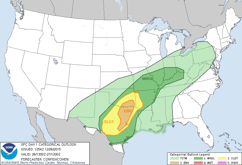
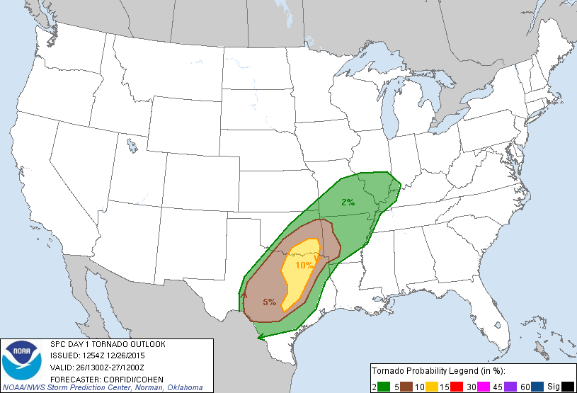
The Storm Prediction Center issues Enhanced Risk for Severe Storms for today across potions of Central, N Central Texas and a small area of Southern Oklahoma. The Texas Cities included in this Enhanced Risk are Austin, Dallas/Ft Worth/Arlington and Plano.

Image
Image
0 likes   
Carla/Alicia/Jerry(In The Eye)/Michelle/Charley/Ivan/Dennis/Katrina/Rita/Wilma/Ike/Harvey

Member: National Weather Association
Wx Infinity Forums
http://wxinfinity.com/index.php

Facebook.com/WeatherInfinity
Twitter @WeatherInfinity

User avatar
Portastorm
Storm2k Moderator
Storm2k Moderator
Posts: 9914
Age: 63
Joined: Fri Jul 11, 2003 9:16 am
Location: Round Rock, TX
Contact:

Re: Texas Winter 2015-2016

#946 Postby Portastorm » Sat Dec 26, 2015 9:30 am

:uarrow:

Definitely growing more concerned about the risk of isolated, discrete supercell formation during the day today in central and south central Texas. If the cap is able to break, look out! At the moment I'm thinking the greater risk is further north along the I-35 corridor from Temple/Killeen northward ... but I'm not ruling out Austin quite yet. Any time SPC ramps up your risk so close to an event ... well, that's an eyebrow raiser for sure.

Be safe everyone!

I'm gassing up the Champ the Charger in case a local storm spotting situation arises near the PWC.
0 likes   
Any forecasts under my name are to be taken with a grain of salt. Get your best forecasts from the National Weather Service and National Hurricane Center.

User avatar
TexasF6
S2K Supporter
S2K Supporter
Posts: 816
Joined: Mon Aug 09, 2004 9:33 pm
Location: Austin, TX

Re: Texas Winter 2015-2016

#947 Postby TexasF6 » Sat Dec 26, 2015 9:37 am

Porta you took the words right outta my mouth. I'm officially concerned. The tornado parameters are there for us..............Houston moreso tomorrow if NAM is right on the soundings I saw....WPC has Austin on the edge of the wintery fun, but in the edge!!! :lol:
0 likes   

User avatar
gboudx
S2K Supporter
S2K Supporter
Posts: 4080
Joined: Thu Sep 04, 2003 1:39 pm
Location: Rockwall, Tx but from Harvey, La

#948 Postby gboudx » Sat Dec 26, 2015 9:40 am

Update from jeff:

High Impact Storm System Heading for TX.

Severe weather and tornadoes increasing likely over much of central and east TX tonight/Sunday

Crippling/life threatening blizzard over W/NW TX tonight-Monday AM

Discussion:
Much advertised upper air storm system is digging into the SW US this morning with high impact potential track across the state of TX the next 48 hours. Incredible warmth continues to spread northward ahead of this powerful system setting the stage for a major clash of the seasons over TX on Sunday. Tremendous height falls are starting to spread into W/SW TX this morning and this will induce rapidly deepening surface low pressure over SW TX this afternoon. Very strong low level jet stream of 50-60kts will develop transporting a summer time air mass across much of eastern and central TX today. Dewpoints already in the mid 70’s with temperatures at 700am only 3 degrees from the daily record high show just how hot and humid the air mass is. SW TX surface low will deepen rapidly as it shift ENE toward SC and then SE TX Sunday. Surface pressure fall toward the upper 990mb’s…so the wind is really going to howl with this event. Impressive lift overspread the large unstable warm sector late tonight into Sunday with all severe modes likely in the warm sector. Very cold air mass surges southward on the backside of the deepening upper level and surface storm systems. Jet on the backside of the surface low really cranks Sunday with likely sustained winds of 40-50mph with gusts of 60-65mph over much of west TX. Cold core upper low transitions to heavy snow in the backside comma precipitation shield with extremely large amounts being forecasted in the blizzard warning areas. All-time and December monthly snowfall records may be challenged with this event over W/NW TX.

Simply stated the next 48 hours will bring major weather impacts to the state of TX.

Severe Threat:

SPC “enhanced” or cat 3 out of 5 severe risk was issued for Day 1 (today) along the I-35 corridor northward across all of N TX. Main reason for the upgrade was to add 10% tornado probabilities into this region for this afternoon and tonight as extremely humid and increasingly unstable air mass moves NW today. Current risk appears to be the most significant tornado threat in the “enhanced area” for the month of December since December 2006. Shear profiles are getting fairly intense with 50-60kt low level jet by this afternoon howling inland off the Gulf of Mexico overlaid with a powerful 120kt mid level jet stream intruding over the region tonight into Sunday. Low level shear profiles are maximized over SE TX Sunday morning with low level helicity values of 200-400 m^2/S^2. Dewpoints in the low to mid 70’s support very low LCL’s (cloud bases). Capping appears to keep a lid on things for most of today…luckily, but formation and track of intense SW TX surface low near/just west of SE TX late tonight/Sunday will place out region very near the “triple point” location and help to maximize the severe threat as this will help back low level winds to the SE increasing low level shear and storm rotation.

Discrete cells early this evening will have a concerning tornado threat along the I-35 corridor…potential is certainly there for fast moving tornadoes this evening with the threat increasing after dark tonight as large scale lift overspreads the warm sector air mass. Think this threat will remain NW of SE TX this evening, but will have to watch for any cells that deepen over SE TX late this afternoon and take advantage of the high shear values.

Upper trough takes on a slight negative tilt early Sunday allowing the cold front and surface low to punch ENE toward the NW parts of SE TX. High resolution models develop a broken line of strong to sever supercells along this boundary Sunday morning and cross SE TX. Forecasted wind shear is concerning for tornado production, but instability is looking a bit weak (800-1500 J/kg). Tremendous wind energy aloft can certainly be transported to the surface in the updrafts and downdrafts with damaging gusts. I am a bit worried with the models showing more of a broken line versus a solid squall line which would point more toward a tornado threat than widespread wind damage. Either way will go with all severe modes (wind damage, tornadoes, and may a few reports of hail).

SPC Day 2 outline has all of SE TX outlooked for slight chances (2 out of 5) risk for severe thunderstorms.

Will update this threat again this afternoon as additional high resolution model data becomes available.

Heavy Rainfall:
Moisture levels are already high and will only deepen more today as Pacific moisture arrives from the SW and we continue the Gulf feed. PWS progged to max out in the 1.7-1.9 inch range with surface dewpoints in the mid 70’s and nearly saturated air column. Simply put this is mid summer moisture getting ready to be squeezed by winter dynamics. Storms will be excellent rainfall producers, but fast forward motions (on the order of 30-50mph) should help to cut back on overall storm totals. Still expecting a solid 1-2 inches over SE TX with higher amounts of 3-5 inches over E/NE TX with isolated totals of 5-10 inches possible especially NE TX where period of cell training is possible. Think the threat for cell training over SE TX will be limited to tonight and early Sunday and mainly focus over the Huntsville to Liberty region.

Such rainfall especially on saturated grounds and already swollen/flooded rivers is only going to cause more issues. Latest QPF forecast ingested in RFC hydro models result in rises to flood stage on the Navasota River and worsen ongoing flooding on the entire Trinity River Basin. Significant rises are noted on the Brazos River basin.

Blizzard:

***Life threatening crippling blizzard to affect much of W/NW TX***

Intensifying upper level low will move across the Hilly Country Sunday with intense surface low tracking from SW to NE TX. Very impressive pressure gradient will develop with this surface low leading to very strong surface winds. Air column will rapidly cool, yet tremendous moisture advection will load the mid levels of the NW side of the mid/upper level low leading to significant snowfall rates. Models show extensive meso scale banding and instability which could lead to 1-3 inch per hour snowfall rates. Looking at some very impressive accumulations of anywhere from 6-18 inches and some locations could see over 20 inches of actual snow. 40-60mph will result in major blowing and drifting with potential for some drifts of 8-10ft high in location from Lubbock to Amarillo. Travel across W/NW TX will be impossible during this blizzard along with the ability for rescue personnel to respond. Expect some areas to have “white-out” conditions for many hours and potential for “ground blizzard” conditions with the howling winds.

Motorists not sheltered in place by this evening stand a high chance of being stranded on local highways and interstates until Monday.

Temperatures:

BUSH IAH, Hobby Airport, and Galveston all record their hottest Christmas Day in history yesterday. The previous record at BUSH IAH was 82 and yesterday reached 83. The warmest overnight low on Christmas morning broken the previous record by 6 degrees at IAH…old record was 67 and the low yesterday was 73! This low so far this morning also breaks the daily record and the record high of 78 (currently 75) will likely fall with a few breaks of sun today.

Record warmth will be ended on Sunday as cold Canadian air mass surges across the region with temperatures tumbling from the 70’s into the 40’s. Cold air will remain in place for the next several days with multiple fronts crossing the area.
0 likes   

User avatar
Ntxw
Storm2k Moderator
Storm2k Moderator
Posts: 22786
Joined: Wed Oct 21, 2009 6:34 pm
Location: DFW, Texas

Re:

#949 Postby Ntxw » Sat Dec 26, 2015 10:36 am

TarrantWx wrote:I haven't watched the Stratosphere temperatures before to know if what is currently happening would classify as a SSW event or not, someone with more experience would have to chime in. But, it looks like something is happening. It looks like an SSW tried to get going in late November and fizzled out, but it looks like another one is trying to get going that is more intense and is still intensifying. Any thoughts? Here is a link to the loop.

http://www.cpc.ncep.noaa.gov/products/intraseasonal/temp10anim.shtml


It would be an SSW. SSW's are complex things, but yeah there have been attempts to attack the very strong PV up there with no success of yet with wave 1 (Pacific ridging). Wave 2 attacks (Pacific and Atlantic<-Eurasia) will happen and is a little stronger. Right now the models say it will disrupt perhaps split the vortex especially a the lower levels and the Arctic circle vortex unravels raising heights and dislocating the tight grip of colder air. Thus -AO pattern.
0 likes   
The above post and any post by Ntxw is NOT an official forecast and should not be used as such. It is just the opinion of the poster and may or may not be backed by sound meteorological data. It is NOT endorsed by any professional institution including Storm2k. For official information, please refer to NWS products.

  Help support Storm2K!
Help Support Storm2K

User avatar
Portastorm
Storm2k Moderator
Storm2k Moderator
Posts: 9914
Age: 63
Joined: Fri Jul 11, 2003 9:16 am
Location: Round Rock, TX
Contact:

Re: Texas Winter 2015-2016

#950 Postby Portastorm » Sat Dec 26, 2015 10:42 am

FWIW, the 12z GFS is rolling in and it appears to have the surface low at 6z Sunday (i.e. midnight tonight) about 80 miles south of where it had it in the 0z run. Then, it really drops the low much further south at 12z Sunday to near Brownsville. How the changes in surface weather might be impacted, I'm not certain but it's a model trend worth following.
0 likes   
Any forecasts under my name are to be taken with a grain of salt. Get your best forecasts from the National Weather Service and National Hurricane Center.

User avatar
Ntxw
Storm2k Moderator
Storm2k Moderator
Posts: 22786
Joined: Wed Oct 21, 2009 6:34 pm
Location: DFW, Texas

Re: Texas Winter 2015-2016

#951 Postby Ntxw » Sat Dec 26, 2015 10:52 am

Portastorm wrote:FWIW, the 12z GFS is rolling in and it appears to have the surface low at 6z Sunday (i.e. midnight tonight) about 80 miles south of where it had it in the 0z run. Then, it really drops the low much further south at 12z Sunday to near Brownsville. How the changes in surface weather might be impacted, I'm not certain but it's a model trend worth following.


GFS changes over to snow briefly for the metroplex towards the end.
0 likes   
The above post and any post by Ntxw is NOT an official forecast and should not be used as such. It is just the opinion of the poster and may or may not be backed by sound meteorological data. It is NOT endorsed by any professional institution including Storm2k. For official information, please refer to NWS products.


  Help support Storm2K!

Help Support Storm2K


User avatar
srainhoutx
S2K Supporter
S2K Supporter
Posts: 6919
Age: 67
Joined: Sun Jan 14, 2007 11:34 am
Location: Haywood County, NC
Contact:

Re: Texas Winter 2015-2016

#952 Postby srainhoutx » Sat Dec 26, 2015 10:55 am

12Z RAOB analysis suggest -40C at 500mb associated with the cold core upper low/trough near Las Vegas into Western Arizona.
0 likes   
Carla/Alicia/Jerry(In The Eye)/Michelle/Charley/Ivan/Dennis/Katrina/Rita/Wilma/Ike/Harvey

Member: National Weather Association
Wx Infinity Forums
http://wxinfinity.com/index.php

Facebook.com/WeatherInfinity
Twitter @WeatherInfinity

User avatar
TheAustinMan
Category 5
Category 5
Posts: 1047
Age: 25
Joined: Mon Jul 08, 2013 4:26 pm
Location: United States
Contact:

#953 Postby TheAustinMan » Sat Dec 26, 2015 11:10 am

Not too sure how much weight should be put into these algorithms, but the NAM 4km seems to suggest that we could be seeing an environment particularly conducive for tornadoes in the Dallas area this evening, though the other mesoscale models and global models seem to assess a marked but not as significant risk.

NAM 4km sounding analysis output for 20z on December 26:

Image
0 likes   
ImageImageImage
Treat my opinions with a grain of salt. For official information see your local weather service.

User avatar
TheProfessor
Professional-Met
Professional-Met
Posts: 3506
Age: 28
Joined: Tue Dec 03, 2013 10:56 am
Location: Wichita, Kansas

Re:

#954 Postby TheProfessor » Sat Dec 26, 2015 11:16 am

TheAustinMan wrote:Not too sure how much weight should be put into these algorithms, but the NAM 4km seems to suggest that we could be seeing an environment particularly conducive for tornadoes in the Dallas area this evening, though the other mesoscale models and global models seem to assess a marked but not as significant risk.

NAM 4km sounding analysis output for 20z on December 26:

http://puu.sh/m9ev4/4409a97851.pn


Nam is usually better at short range severe weather than the global models.
0 likes   
An alumnus of The Ohio State University.

Your local National Weather Service office is your best source for weather information.

User avatar
Ntxw
Storm2k Moderator
Storm2k Moderator
Posts: 22786
Joined: Wed Oct 21, 2009 6:34 pm
Location: DFW, Texas

#955 Postby Ntxw » Sat Dec 26, 2015 11:40 am

There's a sagging cold front in Texas. I cannot wait for it to arrive tonight. I'll be honest this warmth and mugginess to me made it one of the most horrible ways to run Christmas. When you have a house full of people, it's unavoidable to use the AC. Glad it will be over soon.

Image

Image
0 likes   
The above post and any post by Ntxw is NOT an official forecast and should not be used as such. It is just the opinion of the poster and may or may not be backed by sound meteorological data. It is NOT endorsed by any professional institution including Storm2k. For official information, please refer to NWS products.


  Help support Storm2K!

Help Support Storm2K


User avatar
TheProfessor
Professional-Met
Professional-Met
Posts: 3506
Age: 28
Joined: Tue Dec 03, 2013 10:56 am
Location: Wichita, Kansas

#956 Postby TheProfessor » Sat Dec 26, 2015 11:52 am

My goodness it feels like May outside.
0 likes   
An alumnus of The Ohio State University.

Your local National Weather Service office is your best source for weather information.

User avatar
Ntxw
Storm2k Moderator
Storm2k Moderator
Posts: 22786
Joined: Wed Oct 21, 2009 6:34 pm
Location: DFW, Texas

#957 Postby Ntxw » Sat Dec 26, 2015 11:57 am

You folks in central Texas might want to pay attention to the track of the ULL. The Canadian remains the furthest south. While snow is unlikely there, and accumulating snow is even more unlikely but with cold 850s approaching below 0C it wouldn't be too crazy to think the hill country and even some areas further east may see a stray heavy, wet flake or two.

if there is Champ the Charger better be ready
0 likes   
The above post and any post by Ntxw is NOT an official forecast and should not be used as such. It is just the opinion of the poster and may or may not be backed by sound meteorological data. It is NOT endorsed by any professional institution including Storm2k. For official information, please refer to NWS products.


  Help support Storm2K!

Help Support Storm2K


Brent
S2K Supporter
S2K Supporter
Posts: 38091
Age: 36
Joined: Sun May 16, 2004 10:30 pm
Location: Tulsa Oklahoma
Contact:

Re: Texas Winter 2015-2016

#958 Postby Brent » Sat Dec 26, 2015 11:59 am

Wow this air...

it reminds me of the spring.
0 likes   
#neversummer

JayDT
Category 1
Category 1
Posts: 354
Joined: Tue Dec 16, 2014 12:55 pm
Location: Dallas, Texas

#959 Postby JayDT » Sat Dec 26, 2015 12:03 pm

I just saw a tweet from someone who works at the NWS in Ft. Worth say that the storm is moving further south. Im liking this :wink:
0 likes   

dfw75208
Tropical Wave
Tropical Wave
Posts: 3
Joined: Fri Feb 04, 2011 12:32 pm

Re: Texas Winter 2015-2016

#960 Postby dfw75208 » Sat Dec 26, 2015 12:09 pm

Looks like tonight and Sunday will be pretty dramatic, but what about Monday? We are planning to drive west from DFW to Big Spring on Monday and then on the Marfa. What will that look like?
0 likes   


Return to “Winter Weather”

Who is online

Users browsing this forum: No registered users and 9 guests