Texas Winter 2015-2016
Moderator: S2k Moderators
Forum rules
 The posts in this forum are NOT official forecast and should not be used as such. They are just the opinion of the poster and may or may not be backed by sound meteorological data. They are NOT endorsed by any professional institution or STORM2K.

The posts in this forum are NOT official forecast and should not be used as such. They are just the opinion of the poster and may or may not be backed by sound meteorological data. They are NOT endorsed by any professional institution or STORM2K.

Re: Texas Winter 2015-2016
Anyone notice that 6+ inches bullseye of rain in SoCal for the next week? That's crazy! Half annual rainfall for some there. That's like a 15" rainfall here. That drought out there is going to get chopped away in a hurry.
0 likes
The above post and any post by Ntxw is NOT an official forecast and should not be used as such. It is just the opinion of the poster and may or may not be backed by sound meteorological data. It is NOT endorsed by any professional institution including Storm2k. For official information, please refer to NWS products.
Help support Storm2K!


-
orangeblood
- S2K Supporter

- Posts: 3895
- Joined: Tue Dec 15, 2009 6:14 pm
- Location: Fort Worth, TX
Re: Texas Winter 2015-2016
The run to run swings on the GFS are inexcusable, that model is GARBAGE!!
0 likes
Re: Texas Winter 2015-2016
orangeblood wrote:The run to run swings on the GFS are inexcusable, that model is GARBAGE!!
Did you see the massive changes both surface and aloft? Past 4-5 days truly clueless
0 likes
Anything I post is my personal opinion and should not used for any type of planning or lifesaving reasons. Please refer to National Weather Service forecasts.
Laughable really  Stuff here, stuff there. Put this together..wait no put that there! I mean at least stick to something, even if you want to be warm.
Oh man the GFS, this is low even for it.
Oh man the GFS, this is low even for it.
0 likes
The above post and any post by Ntxw is NOT an official forecast and should not be used as such. It is just the opinion of the poster and may or may not be backed by sound meteorological data. It is NOT endorsed by any professional institution including Storm2k. For official information, please refer to NWS products.
Help support Storm2K!
Help support Storm2K!
-
Brent
- S2K Supporter
- Posts: 38769
- Age: 37
- Joined: Sun May 16, 2004 10:30 pm
- Location: Tulsa Oklahoma
- Contact:
Re: Texas Winter 2015-2016
I really have to quit looking at the GFS every run...  didn't they upgrade this model?
0 likes
#neversummer
-
orangeblood
- S2K Supporter
- Posts: 3895
- Joined: Tue Dec 15, 2009 6:14 pm
- Location: Fort Worth, TX
Re: Texas Winter 2015-2016
hriverajr wrote:orangeblood wrote:The run to run swings on the GFS are inexcusable, that model is GARBAGE!!
Did you see the massive changes both surface and aloft? Past 4-5 days truly clueless
Yep, some upper level features are displaced almost 1000 plus miles from run to run, and that's from less than 6 days out. What a waste of taxpayer money!
0 likes
Re: Texas Winter 2015-2016
The lack of run to run consistency is mind boggling. Essentially it's useless right now.
0 likes
Anything I post is my personal opinion and should not used for any type of planning or lifesaving reasons. Please refer to National Weather Service forecasts.
-
Brent
- S2K Supporter
- Posts: 38769
- Age: 37
- Joined: Sun May 16, 2004 10:30 pm
- Location: Tulsa Oklahoma
- Contact:
Re: Texas Winter 2015-2016
lol this run barely even has a freeze at DFW it appears... nice consistency.
0 likes
#neversummer
-
TheProfessor

- Professional-Met

- Posts: 3506
- Age: 29
- Joined: Tue Dec 03, 2013 10:56 am
- Location: Wichita, Kansas
I don't think the GFS is capable right now of handling all the numerous incoming shortwaves and the very strong subtropical jet stream embedded in the split flow type pattern. It just doesn't know what is what and what should go where. There's so many pieces, if it connects the northern and southern jet together it's a big blast, if it misses it's 180...goodness
0 likes
The above post and any post by Ntxw is NOT an official forecast and should not be used as such. It is just the opinion of the poster and may or may not be backed by sound meteorological data. It is NOT endorsed by any professional institution including Storm2k. For official information, please refer to NWS products.
Help support Storm2K!
Help support Storm2K!
At least the Canadian is consistent
0 likes
The above post and any post by Ntxw is NOT an official forecast and should not be used as such. It is just the opinion of the poster and may or may not be backed by sound meteorological data. It is NOT endorsed by any professional institution including Storm2k. For official information, please refer to NWS products.
Help support Storm2K!
Help support Storm2K!

Re: Texas Winter 2015-2016
Well stated from the Ft Worth NWS this morning:
THE GFS SHOWS SOME POTENTIAL
FOR WINTRY PRECIPITATION OVER THE WESTERN CWA DUE TO A COMBINATION
OF LIFT FROM A SHORTWAVE TROUGH AND MID-LEVEL FRONTOGENETIC
FORCING. WHILE THIS WILL UNDOUBTEDLY GET SOME AIR TIME IN SOCIAL
MEDIA... BOTH FEATURES ARE SUB-SYNOPTIC SCALE AND AS SUCH ARE
LIKELY TO CHANGE SIGNIFICANTLY FROM MODEL RUN TO MODEL RUN.
FORECASTING SCALES OF TIME AND SIZE ARE CLOSELY RELATED TO ONE
ANOTHER. WHEN CONFIDENCE IN LARGE SCALE PATTERNS IS LOW...THE
CONFIDENCE IN THE TIMING OF THESE FEATURES IS ALSO VERY LOW. WILL
KEEP A CLOSE EYE ON THE FORECAST FOR EARLY NEXT WEEK AS WE WILL
HAVE COLD AIR IN PLACE. HOWEVER HAVING MOISTURE OR LIFT NECESSARY
FOR WINTRY PRECIPITATION IS NOT SUPPORTED ON THE LARGE SCALE. AS A
RESULT... THE FORECAST REMAINS DRY FOR NOW. WE WILL HAVE TO WAIT
TO SEE IF SMALLER SCALE FEATURES WILL SUPPORT WINTRY PRECIPITATION
AS WE GET CLOSER IN TIME TO EARLY NEXT WEEK.
0 likes
The following post is NOT an official forecast and should not be used as such. It is just the opinion of the poster and may or may not be backed by sound meteorological data. It is NOT endorsed by any professional institution including storm2k.org For Official Information please refer to the NHC and NWS products.
-
wxman57

- Moderator-Pro Met

- Posts: 23175
- Age: 68
- Joined: Sat Jun 21, 2003 8:06 pm
- Location: Houston, TX (southwest)
Re: Texas Winter 2015-2016
orangeblood wrote:The run to run swings on the GFS are inexcusable, that model is GARBAGE!!
Every run looks the same, to me. Cold and miserable. Some runs are just a little colder and more miserable than others. Euro has no snow south of the Red River (outside of the Panhandle) over the next 10 days. Down to the mid 20s in the Dallas area next Monday. Up to the mid to upper 60s across Houston Thu/Fri of this week. Possibly Houston's first (light) freeze next Tuesday. Just lots of useless cold in all the models.
0 likes
-
Portastorm

- Storm2k Moderator

- Posts: 9955
- Age: 63
- Joined: Fri Jul 11, 2003 9:16 am
- Location: Round Rock, TX
- Contact:
Re: Texas Winter 2015-2016
Here's a snippet from Jeff Lindner's forecast note this morning. I think he sums it up pretty well for what we know at the moment:
Extended:
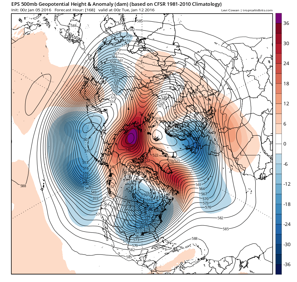
Some of the global models and their ensembles have been suggesting upper air amplification along the US west coast with high pressure ridging deep into the northern latitudes and some degree of high latitude blocking over the northern hemisphere over the next two weeks. There is some potential for an arctic air outbreak into the US at some point post Jan 12-15 time frame, but it remains unclear if this very cold air would head straight down the plains or be shunted more toward the eastern US.
Extended:
Some of the global models and their ensembles have been suggesting upper air amplification along the US west coast with high pressure ridging deep into the northern latitudes and some degree of high latitude blocking over the northern hemisphere over the next two weeks. There is some potential for an arctic air outbreak into the US at some point post Jan 12-15 time frame, but it remains unclear if this very cold air would head straight down the plains or be shunted more toward the eastern US.
0 likes
Any forecasts under my name are to be taken with a grain of salt. Get your best forecasts from the National Weather Service and National Hurricane Center.
-
WeatherGuesser
- Category 5

- Posts: 2672
- Joined: Tue Jun 29, 2010 6:46 am
-
srainhoutx

- S2K Supporter
- Posts: 6919
- Age: 68
- Joined: Sun Jan 14, 2007 11:34 am
- Location: Haywood County, NC
- Contact:
Re:
WeatherGuesser wrote:and their ensembles have been suggesting upper air amplification along the US west coast with high pressure ridging deep into the northern latitudes and some degree of high latitude blocking
Why can't these guys just use English instead of some weird kind of Magical Mystery words?
Sometimes a picture is worth a 1000 words...
0 likes
Carla/Alicia/Jerry(In The Eye)/Michelle/Charley/Ivan/Dennis/Katrina/Rita/Wilma/Ike/Harvey
Member: National Weather Association
Wx Infinity Forums
http://wxinfinity.com/index.php
Facebook.com/WeatherInfinity
Twitter @WeatherInfinity
Member: National Weather Association
Wx Infinity Forums
http://wxinfinity.com/index.php
Facebook.com/WeatherInfinity
Twitter @WeatherInfinity

-
Ralph's Weather
- S2K Supporter
- Posts: 3374
- Age: 38
- Joined: Fri Dec 13, 2013 11:55 am
- Location: Lindale, TX
- Contact:
If yesterday (28) and this morning (26) can get this cold next week even without an ideal Arctic plunge should be able to reach around 20 or even below.
0 likes
Follow on Facebook at Ralph's Weather.
Who is online
Users browsing this forum: No registered users and 214 guests