
Texas Winter 2015-2016
Moderator: S2k Moderators
Forum rules
 The posts in this forum are NOT official forecast and should not be used as such. They are just the opinion of the poster and may or may not be backed by sound meteorological data. They are NOT endorsed by any professional institution or STORM2K.

The posts in this forum are NOT official forecast and should not be used as such. They are just the opinion of the poster and may or may not be backed by sound meteorological data. They are NOT endorsed by any professional institution or STORM2K.
-
aggiecutter
- Category 5

- Posts: 1755
- Joined: Thu Oct 14, 2004 9:22 pm
- Location: Texarkana
Re: Texas Winter 2015-2016
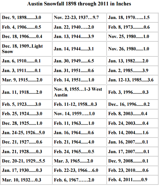
The Austin snow drought. Only once in the past 20 years has Austin received more than an inch of snow from any one storm. As Mr. Spock would say," Fascinating". However, the mid-60's was snowmageddon.
0 likes
-
wxman57

- Moderator-Pro Met

- Posts: 23175
- Age: 68
- Joined: Sat Jun 21, 2003 8:06 pm
- Location: Houston, TX (southwest)
Re: Texas Winter 2015-2016
Ah, here comes the real icy weather. It's at hour 348 of the 18Z GFS:

0 likes
-
Brent
- S2K Supporter

- Posts: 38778
- Age: 37
- Joined: Sun May 16, 2004 10:30 pm
- Location: Tulsa Oklahoma
- Contact:
Re: Texas Winter 2015-2016
And now the gfs has a low of 23 at DFW at 240 hours so much for no freezes
0 likes
#neversummer
-
wxman57
- Moderator-Pro Met
- Posts: 23175
- Age: 68
- Joined: Sat Jun 21, 2003 8:06 pm
- Location: Houston, TX (southwest)
Re: Texas Winter 2015-2016
Brent wrote:And now the gfs has a low of 23 at DFW at 240 hours so much for no freezes
Well, at least the forecast is crystal clear. Somewhere between extremely cold, cold with snow, or warmer with no freezes.

0 likes


Re: Texas Winter 2015-2016
And now you know why I'm hesitant to leave the side of wx57. This winter has been full of promises. Almost like the date a beautiful girl promised you when you were young that never happens  (or boy if your female) hehe
0 likes
-
Yukon Cornelius
- S2K Supporter
- Posts: 1842
- Age: 42
- Joined: Thu Dec 20, 2012 9:23 pm
- Location: Dean, TX/Westcliffe, CO
Re: Texas Winter 2015-2016
No freezes for Texas? Or no freezes from Dallas to Houston? I'm forecasted to be at 27 Tuesday night and 24 Wednesday night with some sort of below freezing temp each night through the end of the week..
0 likes
#neversummer
-
Brent
- S2K Supporter
- Posts: 38778
- Age: 37
- Joined: Sun May 16, 2004 10:30 pm
- Location: Tulsa Oklahoma
- Contact:
Re: Texas Winter 2015-2016
Yukon Cornelius wrote:No freezes for Texas? Or no freezes from Dallas to Houston? I'm forecasted to be at 27 Tuesday night and 24 Wednesday night with some sort of below freezing temp each night through the end of the week..
28 forecast even in Dallas on TV just now for Wednesday Night(that'd be a degree off the coldest of the entire winter)... yeah winter is definitely over...
0 likes
#neversummer
-
weatherdude1108
- Category 5
- Posts: 4228
- Joined: Tue Dec 13, 2011 1:04 pm
- Location: Northwest Austin/Cedar Park, TX
Re: Texas Winter 2015-2016
dhweather wrote:JDawg512 wrote:orangeblood wrote:For all those complaining about no rain...I hope you all realize we just came off the wettest year IN RECORDED HISTORY, please keep in mind....we don't live in The Amazon!!
That doesn't negate the fact that the topsoil is drying out now or the fact that despite 2015 being the wettest on record, we still ended up having wildfires. It does us no good long term when we get one month of 5 to 10 inches then a month or two with less than an inch. Rainfall needs to be more consistent. We get way too much all at once then we have these extended dry spells in between. I'm simply hoping for a better pattern where we get manageable amounts of rain more frequently.
AMEN!
0.83" of rain in Heath for January TOTAL. Second driest January in 6 years.
2011 1.82"
2012 6.35"
2013 3.12"
2014 0.60"
2015 3.44"
2016 0.83"
JDAWG5
JDawg512 wrote:Ntxw wrote:orangeblood wrote:Strat Warming vs. the MJO...which one will win the day over the next few weeks ???? Euro and Canadian say SW, GFS is going with the MJO. Considering the GFS's track record with the MJO this season, it's an easy answer on which one to side with.
As for rain, I'd love for there to be some but it's winter. I'd rather have it in the spring and fall when in matters. The 1-2 inches of on and off spritzes does very little. Droughts starts and ends in the Spring. That's when you know the effects are more dramatic. To be honest I am hoping for a more subdued rain year, came with it last year was the one of the most deadly flooding and tornado year's for North Texas.
Majority of the tornado deaths of 2015 occured in NWS FW forecasting area, also the epicenter of the flooding rains against normals in the nation.
Oh I agree with you about the most important time being Spring. My biggest concern though is when it finally gets below freezing here in my immediate area (which has yet to do so this winter), I'd like the soil to have enough moisture so my plants don't end up with root damage. At this point I'm hand watering daily the more sensitive ones and every couple of days for the others and hope that's enough. Winter can be almost as bad as summer in terms of evaporation especially when you have a succession of dry fronts.
JDawg512 took those words right out of my mouth! EXACTLY what I am thinking. These wet/dry extremes have become the norm, regardless of whatever ENSO background state/teleconnection is going on. I used sprinkler and hand watered landscape today. Puddles actually did form in yard, even at half the watering time as in Summer. The dormancy and low evaporation helps.
0 likes
The preceding post is NOT an official forecast, and should not be used as such. It is only the opinion of the poster and may or may not be backed by sound meteorological data. It is NOT endorsed by any professional institution including storm2k.org. For Official Information please refer to the NHC and NWS products.

Re: Texas Winter 2015-2016
Interesting little system next weekend. Guidance so far doesn't show much but worth a second look no less. As the theme of this year, too warm at the surface for now. (not the system associated with the cold blast expected but prior)
0 likes
The above post and any post by Ntxw is NOT an official forecast and should not be used as such. It is just the opinion of the poster and may or may not be backed by sound meteorological data. It is NOT endorsed by any professional institution including Storm2k. For official information, please refer to NWS products.
Help support Storm2K!
-
Brent
- S2K Supporter
- Posts: 38778
- Age: 37
- Joined: Sun May 16, 2004 10:30 pm
- Location: Tulsa Oklahoma
- Contact:
Re: Texas Winter 2015-2016
Ntxw wrote:Interesting little system next weekend. Guidance so far doesn't show much but worth a second look no less. As the theme of this year, too warm at the surface for now. (not the system associated with the cold blast expected but prior)
The 0z Euro is showing interest too... the 12z Euro had snow along the I-35 corridor but the 0z run has it confined to far W TX.
0 likes
#neversummer
-
wxman57
- Moderator-Pro Met
- Posts: 23175
- Age: 68
- Joined: Sat Jun 21, 2003 8:06 pm
- Location: Houston, TX (southwest)
Re: Texas Winter 2015-2016
Models have backed off on the forecast of snow for the Hill Country next week. I must say, I'm shocked! 00Z Euro does have a light freeze for Dallas-Ft. Worth (30F) on Thursday and a bit colder (26-27F) on the 10th.
0 likes
-
srainhoutx

- S2K Supporter
- Posts: 6919
- Age: 68
- Joined: Sun Jan 14, 2007 11:34 am
- Location: Haywood County, NC
- Contact:
Re: Texas Winter 2015-2016
Morning briefing from Jeff:
Record to near record warmth continues today…but colder air will return late Tuesday.
Southerly flow has greatly moistened the low levels of the atmosphere with dewpoints running 60-65 degrees over much of the area. Light winds overnight and this morning with high dewpoints over chilled near shore waters is resulting in a sea fog bank along the upper and mid TX coast. Visibilities have been bouncing all around this morning along the coast between nearly 0 to over 2 miles at times as the sea fog bank sporadically moves inland. Fog has generally lifted into a stratus bank inland with a slightly stronger breeze. No real change until early Tuesday along the coast so expect the fog bank to be maintained and varying visibilities at times.
Think some areas with enough sun will have no problem reaching 80 today and areas across S and SW TX will likely rise into the 90’s.
Upper level storm system heading for the Midwest today and Tuesday will drive a pre frontal trough across the area early Tuesday followed by a strong frontal passage late Tuesday. Pre-frontal trough may be able to squeeze out a shower or two over the region, but moist surface air mass is generally shallow with very dry air mass above…a function of the air mass since late December. Will go with a generous 30% rain chance…but not expecting much.
Dry WNW winds will lower dewpoints and RH values on Tuesday. Have had a bit of fire behavior over the weekend with dead/frozen winter fuels, but think conditions on Tuesday will not support a critical fire weather concern. Conditions will be elevated however especially west of I-45.
Strong cold front will progress across the area late Tuesday afternoon with strong cold air advection driving temperatures into the 30’s by Wednesday morning. Cold high pressure will build down the plains and into TX with cold nights and cool days Wednesday-Friday. Low temperatures Thursday and again on Friday morning may touch freezing in the normally colder locations and away from urban areas. Overall clear skies and little chance of rain beyond Tuesday.
Next weather system will approach the area on Saturday with increasing clouds over the cold surface dome. Moisture once again looks meager, but strong lift will work with what moisture is available to produce at least a chance of showers over mainly the southern half of the region Saturday. If more moisture than currently expected is available…this system could be fairly wet. However pattern of late has been to take the drier solutions…somewhat unusual for TX El Nino winters.
Next Week:
Some of the longer range forecast models…ECMWF and CMC…have been indicating the development and southward progression of an arctic air mass toward the start of next week. Model solutions this winter have been far less than stellar with both cold air intrusions and potential storm systems at the longer range which leaves little confidence in what may transpire next week. While we have experienced a very nice warming trend these last few days…winter is not over.
0 likes
Carla/Alicia/Jerry(In The Eye)/Michelle/Charley/Ivan/Dennis/Katrina/Rita/Wilma/Ike/Harvey
Member: National Weather Association
Wx Infinity Forums
http://wxinfinity.com/index.php
Facebook.com/WeatherInfinity
Twitter @WeatherInfinity
Member: National Weather Association
Wx Infinity Forums
http://wxinfinity.com/index.php
Facebook.com/WeatherInfinity
Twitter @WeatherInfinity
-
aggiecutter
- Category 5
- Posts: 1755
- Joined: Thu Oct 14, 2004 9:22 pm
- Location: Texarkana

-
orangeblood
- S2K Supporter
- Posts: 3895
- Joined: Tue Dec 15, 2009 6:14 pm
- Location: Fort Worth, TX
Re: Texas Winter 2015-2016

Last edited by orangeblood on Mon Feb 01, 2016 10:12 am, edited 1 time in total.
0 likes
-
Portastorm

- Storm2k Moderator

- Posts: 9955
- Age: 63
- Joined: Fri Jul 11, 2003 9:16 am
- Location: Round Rock, TX
- Contact:
Re: Texas Winter 2015-2016
Yep. Once again it appears the coldest air will be going to our northeast and east. We sure could use a nice stout ridge in the southeast.
0 likes
Any forecasts under my name are to be taken with a grain of salt. Get your best forecasts from the National Weather Service and National Hurricane Center.
Re: Texas Winter 2015-2016
Portastorm wrote::uarrow:
Yep. Once again it appears the coldest air will be going to our northeast and east. We sure could use a nice stout ridge in the southeast.
As it has been since we entered the heart of winter...
0 likes
-
TeamPlayersBlue

- Category 5
- Posts: 3533
- Joined: Tue Feb 02, 2010 1:44 am
- Location: Denver/Applewood, CO
Re: Texas Winter 2015-2016
How on earth can the heights and pattern show what the GFS is showing and the HP isnt even over 1040? Lol.
0 likes
Personal Forecast Disclaimer:
The posts in this forum are NOT official forecast and should not be used as such. They are just the opinion of the poster and may or may not be backed by sound meteorological data. They are NOT endorsed by any professional institution or storm2k.org. For official information, please refer to the NHC and NWS products.
The posts in this forum are NOT official forecast and should not be used as such. They are just the opinion of the poster and may or may not be backed by sound meteorological data. They are NOT endorsed by any professional institution or storm2k.org. For official information, please refer to the NHC and NWS products.


Re: Texas Winter 2015-2016
JB seems to be conceding that MJO will overwhelm the stratwarm after the Feb 5-15 "major cold" period.
Moreover, the cold will be centered in the Midwest and central CONUS during the "major cold" period. That is good news for us (albeit for a limited amount of time). Let's hope he is wrong regarding the extended range.
Moreover, the cold will be centered in the Midwest and central CONUS during the "major cold" period. That is good news for us (albeit for a limited amount of time). Let's hope he is wrong regarding the extended range.
0 likes
-
srainhoutx
- S2K Supporter
- Posts: 6919
- Age: 68
- Joined: Sun Jan 14, 2007 11:34 am
- Location: Haywood County, NC
- Contact:
Re: Texas Winter 2015-2016
Big O wrote:JB seems to be conceding that MJO will overwhelm the stratwarm after the Feb 5-15 "major cold" period.
Moreover, the cold will be centered in the Midwest and central CONUS during the "major cold" period. That is good news for us (albeit for a limited amount of time). Let's hope he is wrong regarding the extended range.
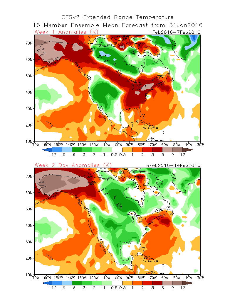
He bases a lot of his long range forecasts off the CFSv2 which has done a fairly good job with our pattern. It certainly caught the dry spell and continues it into February. Colder temperature anomalies are centered across the Plains and the Mid West for February. We will see if the CFSv2 is correct.
0 likes
Carla/Alicia/Jerry(In The Eye)/Michelle/Charley/Ivan/Dennis/Katrina/Rita/Wilma/Ike/Harvey
Member: National Weather Association
Wx Infinity Forums
http://wxinfinity.com/index.php
Facebook.com/WeatherInfinity
Twitter @WeatherInfinity
Member: National Weather Association
Wx Infinity Forums
http://wxinfinity.com/index.php
Facebook.com/WeatherInfinity
Twitter @WeatherInfinity
-
orangeblood
- S2K Supporter
- Posts: 3895
- Joined: Tue Dec 15, 2009 6:14 pm
- Location: Fort Worth, TX
Re: Texas Winter 2015-2016
srainhoutx wrote:Big O wrote:JB seems to be conceding that MJO will overwhelm the stratwarm after the Feb 5-15 "major cold" period.
Moreover, the cold will be centered in the Midwest and central CONUS during the "major cold" period. That is good news for us (albeit for a limited amount of time). Let's hope he is wrong regarding the extended range.
He bases a lot of his long range forecasts off the CFSv2 which has done a fairly good job with our pattern. It certainly caught the dry spell and continues it into February. Colder temperature anomalies are centered across the Plains and the Mid West for February. We will see if the CFSv2 is correct.
Actually, he seems to despise the CFSv2 and hasn't followed its forecast much at all this winter - is why his forecasts have been so terrible up to this point! He had us 3-4 deg. below normal and we're sitting at 3 above so far. CFSv2 has actually done a decent job so far this winter.
0 likes
Who is online
Users browsing this forum: No registered users and 74 guests