Texas Spring 2016

U.S. & Caribbean Weather Discussions and Severe Weather Events

Moderator: S2k Moderators

Forum rules

The posts in this forum are NOT official forecast and should not be used as such. They are just the opinion of the poster and may or may not be backed by sound meteorological data. They are NOT endorsed by any professional institution or STORM2K.

Help Support Storm2K
Message
Author
User avatar
TeamPlayersBlue
Category 5
Category 5
Posts: 3444
Joined: Tue Feb 02, 2010 1:44 am
Location: Denver/Applewood, CO

Re: Texas Spring 2016

#141 Postby TeamPlayersBlue » Mon Mar 07, 2016 1:19 pm

wxman57 wrote:12Z Euro has a 10" bullseye over southwest Houston and eastern Ft. Bend County, mostly on Wednesday. Much of Harris County with 5-8" Tuesday evening through Wednesday afternoon.


Geez. Can you post a map? Thanks for the info!
0 likes   
Personal Forecast Disclaimer:
The posts in this forum are NOT official forecast and should not be used as such. They are just the opinion of the poster and may or may not be backed by sound meteorological data. They are NOT endorsed by any professional institution or storm2k.org. For official information, please refer to the NHC and NWS products.

User avatar
Ntxw
Storm2k Moderator
Storm2k Moderator
Posts: 22730
Joined: Wed Oct 21, 2009 6:34 pm
Location: DFW, Texas

Re: Texas Spring 2016

#142 Postby Ntxw » Mon Mar 07, 2016 1:35 pm

Yeah euro is widespread 4-8" along I-35 and east. I-45 and vicinity gets more 6-10". A lot will be dependent on small scale features and boundaries.

Simply the watersheds and lakes will be inundated with lots of water
0 likes   
The above post and any post by Ntxw is NOT an official forecast and should not be used as such. It is just the opinion of the poster and may or may not be backed by sound meteorological data. It is NOT endorsed by any professional institution including Storm2k. For official information, please refer to NWS products.

  Help support Storm2K!
Help Support Storm2K

HockeyTx82
S2K Supporter
S2K Supporter
Posts: 2450
Joined: Tue Oct 27, 2009 11:17 am
Location: Ponder, TX

Re: Texas Spring 2016

#143 Postby HockeyTx82 » Mon Mar 07, 2016 1:40 pm

So I think I just heard on WFAA, Ch 8 news @ 12, that the emergency sirens are not working in Denton? Anyone else confirm?

Edit, so I called the city of Denton and Mike in charge of the system said no issues. So I guess I misheard.
Last edited by HockeyTx82 on Mon Mar 07, 2016 1:58 pm, edited 1 time in total.
0 likes   
Don't hold me accountable for anything I post on this forum. Leave the real forecasting up to the professionals.

Location: Ponder, TX (all observation posts are this location unless otherwise noted)

User avatar
wxman57
Moderator-Pro Met
Moderator-Pro Met
Posts: 22951
Age: 67
Joined: Sat Jun 21, 2003 8:06 pm
Location: Houston, TX (southwest)

Re: Texas Spring 2016

#144 Postby wxman57 » Mon Mar 07, 2016 1:56 pm

TeamPlayersBlue wrote:
wxman57 wrote:12Z Euro has a 10" bullseye over southwest Houston and eastern Ft. Bend County, mostly on Wednesday. Much of Harris County with 5-8" Tuesday evening through Wednesday afternoon.


Geez. Can you post a map? Thanks for the info!


Here's a graphic I made from the 12Z Euro:

Image
0 likes   

User avatar
Tireman4
S2K Supporter
S2K Supporter
Posts: 5851
Age: 59
Joined: Fri Jun 30, 2006 1:08 pm
Location: Humble, Texas
Contact:

Re: Texas Spring 2016

#145 Postby Tireman4 » Mon Mar 07, 2016 2:23 pm

Oh coming home in rush hour traffic in Houston that day will be fun. Fun, I tell ya.
0 likes   

User avatar
gboudx
S2K Supporter
S2K Supporter
Posts: 4080
Joined: Thu Sep 04, 2003 1:39 pm
Location: Rockwall, Tx but from Harvey, La

Re: Texas Spring 2016

#146 Postby gboudx » Mon Mar 07, 2016 2:50 pm

Tireman4 wrote:Oh coming home in rush hour traffic in Houston that day will be fun. Fun, I tell ya.


Especially if that naked woman dancing on top an 18-wheeler shows up again. :)

For those that haven't heard this story:

http://www.khou.com/story/news/traffic/ ... /81430358/
0 likes   

WeatherGuesser
Category 5
Category 5
Posts: 2672
Joined: Tue Jun 29, 2010 6:46 am

Re: Texas Spring 2016

#147 Postby WeatherGuesser » Mon Mar 07, 2016 3:11 pm

Image
0 likes   

User avatar
jasons2k
Storm2k Executive
Storm2k Executive
Posts: 8238
Age: 51
Joined: Wed Jul 06, 2005 12:32 pm
Location: The Woodlands, TX

Re: Texas Spring 2016

#148 Postby jasons2k » Mon Mar 07, 2016 4:03 pm

Yes, it's looking more like we're going to have some flooding issues to contend with in and around the Houston area.
0 likes   

User avatar
jasons2k
Storm2k Executive
Storm2k Executive
Posts: 8238
Age: 51
Joined: Wed Jul 06, 2005 12:32 pm
Location: The Woodlands, TX

Re: Texas Spring 2016

#149 Postby jasons2k » Mon Mar 07, 2016 4:08 pm

Just got an alert on my iPhone a Flood Watch was issued...

FLOOD WATCH
NATIONAL WEATHER SERVICE HOUSTON/GALVESTON TX
302 PM CST MON MAR 7 2016

TXZ163-164-176>179-195>200-210>214-226-227-235>238-081200-
/O.NEW.KHGX.FF.A.0001.160308T1800Z-160310T0000Z/
/00000.0.ER.000000T0000Z.000000T0000Z.000000T0000Z.OO/
AUSTIN-BRAZORIA-BRAZOS-BURLESON-CHAMBERS-COLORADO-FORT BEND-
GALVESTON-GRIMES-HARRIS-HOUSTON-JACKSON-LIBERTY-MADISON-MATAGORDA-
MONTGOMERY-POLK-SAN JACINTO-TRINITY-WALKER-WALLER-WASHINGTON-
WHARTON-
INCLUDING THE CITIES OF...ALVIN...ANAHUAC...ANGLETON...BAY CITY...
BELLVILLE...BRENHAM...BROOKSHIRE...BRYAN...CALDWELL...CLEVELAND...
COLDSPRING...COLLEGE STATION...COLUMBUS...CONROE...CORRIGAN...
CROCKETT...DAYTON...EAGLE LAKE...EDNA...EL CAMPO...FREEPORT...
FRIENDSWOOD...GALVESTON...GROVETON...HEMPSTEAD...HOUSTON...
HUMBLE...HUNTSVILLE...KATY...LAKE JACKSON...LAKE SOMERVILLE...
LEAGUE CITY...LIBERTY...LIVINGSTON...MADISONVILLE...
MISSOURI CITY...MONT BELVIEU...NAVASOTA...ONALASKA...PALACIOS...
PASADENA...PEARLAND...PIERCE...PRAIRIE VIEW...RICHMOND...
ROSENBERG...SEALY...SHEPHERD...SUGAR LAND...TEXAS CITY...
THE WOODLANDS...TOMBALL...TRINITY...WEIMAR...WHARTON...WILLIS...
WINNIE
302 PM CST MON MAR 7 2016

...FLASH FLOOD WATCH IN EFFECT FROM NOON TUESDAY THROUGH
WEDNESDAY AFTERNOON...

THE NATIONAL WEATHER SERVICE IN HOUSTON/GALVESTON HAS ISSUED A

* FLASH FLOOD WATCH FOR A PORTION OF SOUTHEAST TEXAS...INCLUDING
THE FOLLOWING AUSTIN...BRAZORIA...BRAZOS...BURLESON...
CHAMBERS...COLORADO...FORT BEND...GALVESTON...GRIMES...
HARRIS...HOUSTON...JACKSON...LIBERTY...MADISON...MATAGORDA...
MONTGOMERY...POLK...SAN JACINTO...TRINITY...WALKER...WALLER...
WASHINGTON AND WHARTON.

* FROM NOON TUESDAY THROUGH WEDNESDAY AFTERNOON

* PERIODS OF SHOWERS AND THUNDERSTORMS ASSOCIATED WITH A SLOW-
MOVING STORM SYSTEM ARE EXPECTED TO MOVE ACROSS SOUTHEAST TEXAS
TUESDAY AFTERNOON THROUGH WEDNESDAY AFTERNOON.

* TIMING... HEAVIEST RAINS ARE EXPECTED TUESDAY NIGHT INTO
WEDNESDAY MORNING.

* AMOUNTS... WIDESPREAD RAINFALL AMOUNTS OF 3 TO 7 INCHES ARE
EXPECTED WITH LOCALLY HIGHER AMOUNTS POSSIBLY APPROACHING 10 TO
12 INCHES.

* MAIN THREAT...FLASH FLOODING OF LOW LYING LOCATIONS ESPECIALLY
IN URBAN AREAS WITH POOR DRAINAGE OR RURAL ROADS IN HILLY
TERRAIN CAN BE EXPECTED. FLOODING OF STREAMS... CREEKS... AND
BAYOUS IS LIKELY THROUGH WEDNESDAY. HEAVY RAINFALL MAY CAUSE
SIGNIFICANT TRAVEL IMPACTS DURING THE WEDNESDAY MORNING COMMUTE.

PRECAUTIONARY/PREPAREDNESS ACTIONS...

A FLASH FLOOD WATCH MEANS THAT CONDITIONS MAY DEVELOP THAT LEAD
TO FLASH FLOODING. FLASH FLOODING IS A VERY DANGEROUS SITUATION.

YOU SHOULD MONITOR LATER FORECASTS AND BE PREPARED TO TAKE ACTION
SHOULD FLASH FLOOD WARNINGS BE ISSUED.

&&
0 likes   

User avatar
Tireman4
S2K Supporter
S2K Supporter
Posts: 5851
Age: 59
Joined: Fri Jun 30, 2006 1:08 pm
Location: Humble, Texas
Contact:

Re: Texas Spring 2016

#150 Postby Tireman4 » Mon Mar 07, 2016 4:12 pm

Figured that was coming. You cannot ignore the GFS or the Euro on these numbers...
0 likes   

User avatar
Tireman4
S2K Supporter
S2K Supporter
Posts: 5851
Age: 59
Joined: Fri Jun 30, 2006 1:08 pm
Location: Humble, Texas
Contact:

Re: Texas Spring 2016

#151 Postby Tireman4 » Mon Mar 07, 2016 4:14 pm

gboudx wrote:
Tireman4 wrote:Oh coming home in rush hour traffic in Houston that day will be fun. Fun, I tell ya.


Especially if that naked woman dancing on top an 18-wheeler shows up again. :)

For those that haven't heard this story:

http://www.khou.com/story/news/traffic/ ... /81430358/


I know. Another day, another dollar. Sigh. I hope she gets the help she needs.
0 likes   

weatherdude1108
Category 5
Category 5
Posts: 4228
Joined: Tue Dec 13, 2011 1:04 pm
Location: Northwest Austin/Cedar Park, TX

Re: Texas Spring 2016

#152 Postby weatherdude1108 » Mon Mar 07, 2016 4:51 pm

Tireman4 wrote:
gboudx wrote:
Tireman4 wrote:Oh coming home in rush hour traffic in Houston that day will be fun. Fun, I tell ya.


Especially if that naked woman dancing on top an 18-wheeler shows up again. :)

For those that haven't heard this story:

http://www.khou.com/story/news/traffic/ ... /81430358/


I know. Another day, another dollar. Sigh. I hope she gets the help she needs.


Oh my. :lol: Only in Houston (kidding).
0 likes   
The preceding post is NOT an official forecast, and should not be used as such. It is only the opinion of the poster and may or may not be backed by sound meteorological data. It is NOT endorsed by any professional institution including storm2k.org. For Official Information please refer to the NHC and NWS products.

weatherdude1108
Category 5
Category 5
Posts: 4228
Joined: Tue Dec 13, 2011 1:04 pm
Location: Northwest Austin/Cedar Park, TX

Re: Texas Spring 2016

#153 Postby weatherdude1108 » Mon Mar 07, 2016 4:58 pm

Could be a wet week after we get through this heavy storm threat. The soil in my yard has cracks in it. It needs the water. It would be nice to erase the deficit for this year, even though we are still way ahead if you count last year's rains.

AREA FORECAST DISCUSSION
NATIONAL WEATHER SERVICE AUSTIN/SAN ANTONIO TX
334 PM CST MON MAR 7 2016

.SHORT TERM (TONIGHT THROUGH TUESDAY NIGHT)...
07/12Z AREA RAOBS SHOW A STOUT CAPPING INVERSION IN PLACE AROUND 760-
780MB. DESPITE THIS INVERSION...SOME ELEVATED SHOWERS AND
THUNDERSTORMS HAVE MANAGED TO DEVELOP ACROSS PORTIONS OF CENTRAL AND
NORTH TEXAS...WITH EVEN A FEW SHOWERS ACROSS THE WESTERN HILL
COUNTRY OF SOUTH CENTRAL TEXAS. OTHERWISE...THE WATER VAPOR
SATELLITE LOOP SHOWS A STRONG...NEGATIVE TILT TROUGH DROPPING
SOUTHWARD ACROSS SOUTHERN CALIFORNIA AND BAJA MEXICO.

FOR THE REMAINDER OF THIS AFTERNOON INTO THE EARLY EVENING
HOURS...WE EXPECT SOME ISOLATED STRONG TO POSSIBLY SEVERE
THUNDERSTORM DEVELOPMENT ALONG THE DRYLINE. THE DRYLINE IS EXPECTED
TO MIX EASTWARD AND APPROACH WESTERN VAL VERDE COUNTY BY LATE THIS
AFTERNOON. ANY ACTIVITY ALONG THE DRYLINE WOULD MOST LIKELY REMAIN
ACROSS THE SOUTHERN EDWARDS PLATEAU AND RIO GRANDE PLAINS FROM NEAR
DEL RIO TO ROCKSPRINGS AND NORTHWARD. THROUGH THE REMAINDER OF THE
EVENING AND EARLY MORNING HOURS...ADDITIONAL SHOWERS AND
THUNDERSTORMS ARE EXPECTED TO DEVELOP ACROSS WEST CENTRAL TEXAS AND
THE WESTERN HILL COUNTRY. ACTIVITY WILL BECOME A LITTLE MORE
WIDESPREAD AS WARM AIR ADVECTION IN THE LOW LEVELS ALONG WITH
COOLING IN THE MID-LEVELS HELPS TO DESTABILIZE THE ATMOSPHERE. WHILE
SOME OF THIS ACTIVITY COULD EVENTUALLY MOVE INTO THE I-35 CORRIDOR
NORTH OF SAN ANTONIO...MOST SHORT RANGE GUIDANCE SUGGESTS THE BULK
OF THE THUNDERSTORM ACTIVITY WILL REMAIN OVER THE WESTERN HILL
COUNTRY.

ON TUESDAY...THE ABOVE MENTIONED UPPER LEVEL TROUGH CONTINUES TO
DEVELOP INTO A CLOSED LOW WHILE TRANSLATING EASTWARD. DEEP LAYER
FORCING FOR ASCENT WILL SPREAD OVER ALL OF SOUTH CENTRAL
TEXAS...ESPECIALLY DURING THE EVENING AND OVERNIGHT HOURS INTO
WEDNESDAY MORNING.
THE MEDIUM RANGE MODELS CONTINUE TO REMAIN
CONSISTENT IN SHOWING WIDESPREAD CONVECTION ACROSS THE REGION FOR
THE ABOVE MENTIONED PERIOD. GIVEN THE AMOUNT OF SHEAR AND
INSTABILITY... STRONG TO SEVERE THUNDERSTORM DEVELOPMENT IS
EXPECTED. THE MAIN CONCERN WILL BE DAMAGING WIND GUSTS AND HAIL.

SOME LOCALLY HEAVY RAINFALL IS ALSO EXPECTED AND SOME FLOODING
REMAINS POSSIBLE...PARTICULARLY OVER URBAN AREAS. WE STILL EXPECT
AVERAGE RAINFALL AMOUNTS THROUGH WEDNESDAY MORNING OF NEAR 1 INCH
ALONG THE RIO GRANDE...2 TO 3 INCHES ALONG THE I-35 CORRIDOR
AND
NEAR 4 INCHES ALONG HIGHWAY 77.

&&

.LONG TERM (WEDNESDAY THROUGH MONDAY)...
THE UPPER LOW CONTINUES TO SLOWLY MOVE EASTWARD ON THURSDAY WHILE
TAKING ON A MORE NEUTRAL TILT.
THE OPERATIONAL GFS AND ECMWF
CONTINUE TO DIFFER IN HANDLING THE POSITION OF THE LOW...WITH THE
GFS FARTHER NORTH INTO CENTRAL TEXAS AND THE ECMWF FARTHER SOUTH
OVER DEEP SOUTH TEXAS. WPC PRODUCTS TEND TO FAVOR THE FARTHER
SOUTH SOLUTION AS SHOWN BY THE ECMWF/ECMWF ENSEMBLE AND GEFS. SEE
NO REASON TO DEVIATE FROM THIS SOLUTION AT THIS TIME. WE/LL NEED
TO MONITOR THIS SCENARIO CAREFULLY AS THE ECMWF SOLUTION WOULD
LEAD TO ANOTHER ROUND OF MODERATE TO LOCALLY HEAVY RAINFALL ACROSS
SOUTH CENTRAL TEXAS. WE CURRENTLY HAVE RAIN CHANCES IN THE 50-60%
RANGE AND THIS MAY NEED TO BE RAISED IF SUBSEQUENT MODEL DATA
REMAINS CONSISTENT. THE FORECAST FOR THE REMAINDER OF THE WORK
WEEK INTO THE UPCOMING WEEKEND REMAINS UNCERTAIN AS MUCH WILL
DEPEND ON THE TRACK OF THE UPPER LOW. FOR NOW...WE/LL CONTINUE
RAIN CHANCES FOR MOST AREAS ON FRIDAY
AND CALL FOR DRY CONDITIONS
FOR THE UPCOMING WEEKEND.
0 likes   
The preceding post is NOT an official forecast, and should not be used as such. It is only the opinion of the poster and may or may not be backed by sound meteorological data. It is NOT endorsed by any professional institution including storm2k.org. For Official Information please refer to the NHC and NWS products.

User avatar
jasons2k
Storm2k Executive
Storm2k Executive
Posts: 8238
Age: 51
Joined: Wed Jul 06, 2005 12:32 pm
Location: The Woodlands, TX

Re: Texas Spring 2016

#154 Postby jasons2k » Mon Mar 07, 2016 5:33 pm

weatherdude1108 wrote:
Tireman4 wrote:
gboudx wrote:
Especially if that naked woman dancing on top an 18-wheeler shows up again. :)

For those that haven't heard this story:

http://www.khou.com/story/news/traffic/ ... /81430358/


I know. Another day, another dollar. Sigh. I hope she gets the help she needs.


Oh my. :lol: Only in Houston (kidding).


It's usually Florida. Just sayin' :ggreen: :ggreen:
0 likes   

User avatar
jasons2k
Storm2k Executive
Storm2k Executive
Posts: 8238
Age: 51
Joined: Wed Jul 06, 2005 12:32 pm
Location: The Woodlands, TX

Re: Texas Spring 2016

#155 Postby jasons2k » Mon Mar 07, 2016 6:13 pm

Latest from Jeff:

***High impact….dangerous storm system…heading for SE TX***

Flash Flood Watch issued all counties from noon Tuesday-Wednesday evening

Coastal Flood Watch in effect Harris, Brazoria, Galveston, and Chambers Counties

Rainfall:
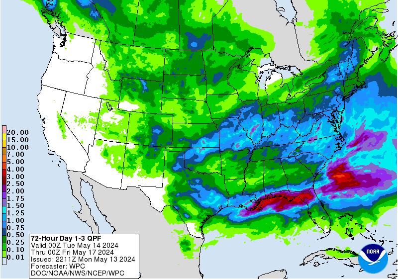
Significant change is required in the expected rainfall amounts for this event…potentially leading to a dangerous flash flood event for E/SE TX. Latest model guidance has continued the trend of shifting the axis of heavy SSW and deeper into SE TX. This is requiring the adjusting upwards of rainfall totals over the next 24-36 hours. Combination of “tremendous” tropical moisture…rising to record levels for early March…massive upper level divergence on the east side of a monster upper level trough…a strong low level jet of 45kts feeding a continuous supply of moisture into a potentially WSW to ENE low level boundary all point to a very high flash flood threat from training strong thunderstorms over SE TX Tuesday evening/overnight.

Widespread Rainfall: 4-6 inches
Isolated Rainfall: 8-10 inches


Note that the amounts listed above are still lower than some guidance including some of the HPC graphics and HGX totals which are pushing isolated totals toward 12 inches. Would certainly not be surprised with 10-12 inches, but the narrow training bands that such totals will fall under I have no confidence of at this time. Will favor areas E of I-45 for maximum totals, but the entire area is under the gun!

Large scale rises on all watersheds are almost certain with this magnitude of rainfall and some will likely exceed their flood stages. If model trends and totals hold into tomorrow morning…we are facing a very serious flood/flash flood threat over this region.

Severe:
All parameters a go for a prolonged severe weather threat from early afternoon Tuesday into Wednesday morning. Low level wind fields really ramp up Tuesday afternoon and evening and suspect a tornado and wind damage threat from high precipitation supercells. Cells will be translating toward the NNE at 35-40mph, but some areas will be hit multiple times in training bands. Large scale upper air forcing arriving across the Rio Grande late Tuesday will force a large MCS to form and track ENE across SC/coastal bend into SE TX Wednesday morning. Will maintain wind damage threat with this line along with a tornado threat (likely lower than Tuesday evening).

Tides:
Tides are already coming up with strong onshore winds and the winds will only increase with strong gradient in place. Expecting 25-35mph with higher gusts Tuesday pushing water into the coast. ET surge showing an impressive 2 ft of surge at Galveston and total water level rise up around 3.5-4.0 ft which is close to causing minor flooding and overwash especially on Bolivar (Hwy 87). Could see some issues on the west side of Galveston Bay also.

Decision Support:


Widespread Rainfall Amounts and Timing:
600am Tues-600pm Tues: 1-2 inches
600pm Tues-600am Wed: 3-5 inches
600am Wed-600pm Wed: 2-4 inches

Flash Flood Guidance (Harris County):
1-hr: 3.4
3-hr: 4.0
6-hr: 4.9

Onset Timing:
Noon-300pm Tuesday

Duration:
Noon Tuesday-600pm Wednesday

Severe:
Tornado: low to moderate
Wind: moderate (60mph+ gusts)
Hail: low (1 inch or larger)


Latest (72 hours rainfall forecast):

http://www.wpc.ncep.noaa.gov/qpf/d13_fi ... 7392196180

Tuesday (Severe Weather Outlook):
http://www.spc.noaa.gov/products/outloo ... 7392234677
0 likes   

User avatar
TeamPlayersBlue
Category 5
Category 5
Posts: 3444
Joined: Tue Feb 02, 2010 1:44 am
Location: Denver/Applewood, CO

Re: Texas Spring 2016

#156 Postby TeamPlayersBlue » Mon Mar 07, 2016 6:36 pm

The HRRR is showing lots of action already for West Texas in the middle of the night. A few Supercells out in West Texas and torrential rain in DFW by rush hour.
0 likes   
Personal Forecast Disclaimer:
The posts in this forum are NOT official forecast and should not be used as such. They are just the opinion of the poster and may or may not be backed by sound meteorological data. They are NOT endorsed by any professional institution or storm2k.org. For official information, please refer to the NHC and NWS products.

Brent
S2K Supporter
S2K Supporter
Posts: 37988
Age: 36
Joined: Sun May 16, 2004 10:30 pm
Location: Tulsa Oklahoma
Contact:

Re: Texas Spring 2016

#157 Postby Brent » Mon Mar 07, 2016 7:28 pm

Significant tornado damage reported just east of Mineral Wells. Looks like a spinup. CBS 11 came up on damage.
0 likes   
#neversummer

User avatar
Tireman4
S2K Supporter
S2K Supporter
Posts: 5851
Age: 59
Joined: Fri Jun 30, 2006 1:08 pm
Location: Humble, Texas
Contact:

Re: Texas Spring 2016

#158 Postby Tireman4 » Mon Mar 07, 2016 7:38 pm

Here we go....
0 likes   

User avatar
TeamPlayersBlue
Category 5
Category 5
Posts: 3444
Joined: Tue Feb 02, 2010 1:44 am
Location: Denver/Applewood, CO

Re: Texas Spring 2016

#159 Postby TeamPlayersBlue » Mon Mar 07, 2016 7:57 pm

Went to Home Depot earlier today, bought 20ft worth of a steel poles for the weather station to be in clear air. Cleaned the inside out, ready for this event.
0 likes   
Personal Forecast Disclaimer:
The posts in this forum are NOT official forecast and should not be used as such. They are just the opinion of the poster and may or may not be backed by sound meteorological data. They are NOT endorsed by any professional institution or storm2k.org. For official information, please refer to the NHC and NWS products.

User avatar
Ntxw
Storm2k Moderator
Storm2k Moderator
Posts: 22730
Joined: Wed Oct 21, 2009 6:34 pm
Location: DFW, Texas

Re: Texas Spring 2016

#160 Postby Ntxw » Mon Mar 07, 2016 8:18 pm

In addition to that a lot of Palo Pinto county has already picked up 4-5" of rain.
0 likes   
The above post and any post by Ntxw is NOT an official forecast and should not be used as such. It is just the opinion of the poster and may or may not be backed by sound meteorological data. It is NOT endorsed by any professional institution including Storm2k. For official information, please refer to NWS products.


  Help support Storm2K!

Help Support Storm2K


Return to “USA & Caribbean Weather”

Who is online

Users browsing this forum: Google Adsense [Bot], Gotwood, rwfromkansas, Storm861, TomballEd, txtwister78, WaveBreaking and 42 guests