
Good Afternoon All,
If I were trying to research historical tropical system tracks for systems that formed in the GoM or Bay of Campeche, then made landfall on the Gulf Coast, any idea how to narrow this type of information down? I also need it to be in a all in one chart format, like the spaghetti model look. Thanks!
Specific Tropical System Historical Tracks
Moderator: S2k Moderators
Specific Tropical System Historical Tracks
0 likes
Personal Forecast Disclaimer:
The posts in this forum are NOT official forecast and should not be used as such. They are just the opinion of the poster and may or may not be backed by sound meteorological data. They are NOT endorsed by any professional institution or storm2k.org. For official information, please refer to the NHC and NWS products.
The posts in this forum are NOT official forecast and should not be used as such. They are just the opinion of the poster and may or may not be backed by sound meteorological data. They are NOT endorsed by any professional institution or storm2k.org. For official information, please refer to the NHC and NWS products.
-
TheAustinMan

- Category 5

- Posts: 1060
- Joined: Mon Jul 08, 2013 4:26 pm
- Location: Central TX / United States
Re: Specific Tropical System Historical Tracks
While I don't know of any places where you can make a search for such variables (i.e. formed in Gulf of Mexico OR Bay of Campeche AND made landfall on the Gulf Coast), but there is a site where you can pinpoint a 1-200 nautical mile radius area and find storms that passed through that area (Does not work with Google Chrome). You can also refine the location search by changing the wind speed, month, pressure, and even ENSO variables.
Example below:

Example below:
0 likes
Treat my opinions with a grain of salt. For official information see your local weather service.
“It's tough to make predictions, especially about the future.”
“It's tough to make predictions, especially about the future.”
Re: Specific Tropical System Historical Tracks
Thanks, I saw that, but I was looking more for animated cone of uncertainty archives. I can't even find standalone cone archives though. Any idea where those would be?
0 likes
Personal Forecast Disclaimer:
The posts in this forum are NOT official forecast and should not be used as such. They are just the opinion of the poster and may or may not be backed by sound meteorological data. They are NOT endorsed by any professional institution or storm2k.org. For official information, please refer to the NHC and NWS products.
The posts in this forum are NOT official forecast and should not be used as such. They are just the opinion of the poster and may or may not be backed by sound meteorological data. They are NOT endorsed by any professional institution or storm2k.org. For official information, please refer to the NHC and NWS products.
-
TheAustinMan
- Category 5
- Posts: 1060
- Joined: Mon Jul 08, 2013 4:26 pm
- Location: Central TX / United States
Re: Specific Tropical System Historical Tracks
SoupBone wrote:Thanks, I saw that, but I was looking more for animated cone of uncertainty archives. I can't even find standalone cone archives though. Any idea where those would be?
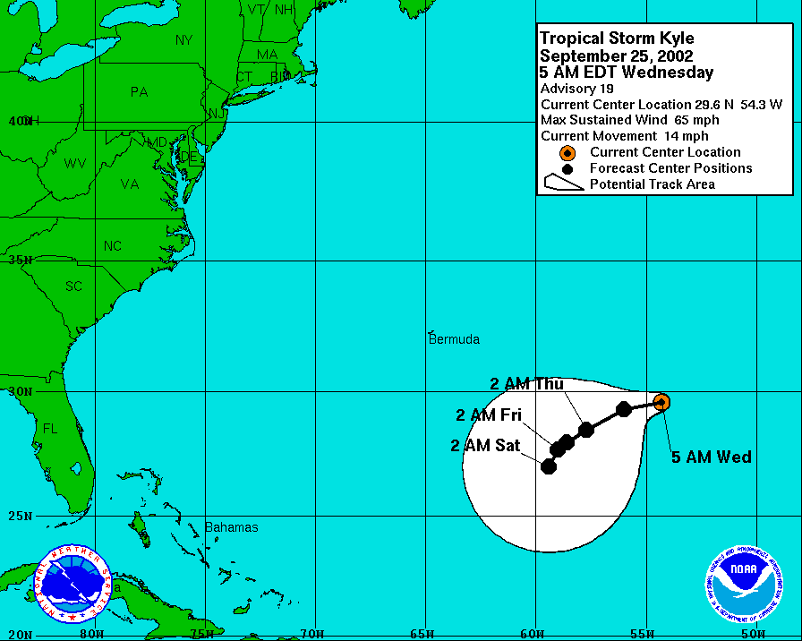
For storms since 2002, the National Hurricane Center hosts archives of cones of uncertainty at http://www.nhc.noaa.gov/archive/2016/, though you'll have to navigate to the storm page, then click Graphics Archive, followed by the graphic of your choosing. I'm not sure where to find older cones of uncertainties, however.
As an example, here's a 3-day forecast cone for Hurricane Kyle back in 2002
0 likes
Treat my opinions with a grain of salt. For official information see your local weather service.
“It's tough to make predictions, especially about the future.”
“It's tough to make predictions, especially about the future.”
Return to “Got a question? I'm listening”
Who is online
Users browsing this forum: No registered users and 13 guests