Seasonal Indicators (Beyond Day 16): Instability / SST's / MSLP / Steering / Sal
Moderator: S2k Moderators
Forum rules

The posts in this forum are NOT official forecasts and should not be used as such. They are just the opinion of the poster and may or may not be backed by sound meteorological data. They are NOT endorsed by any professional institution or STORM2K. For official information, please refer to products from the National Hurricane Center and National Weather Service.


Re: 2016 indicators: Instability / SST's / MSLP / Steering / Sal
A lot of emphasis on the gulf. But usually before they get to the gulf they probably came from the Caribbean! Hasn't been much of the gulf threat past few years because the Caribbean has graveyard most of the waves. So perhaps this year that will change? We say storms that go into the gulf has to hit somebody, well same goes for the Caribbean.
0 likes
The above post and any post by Ntxw is NOT an official forecast and should not be used as such. It is just the opinion of the poster and may or may not be backed by sound meteorological data. It is NOT endorsed by any professional institution including Storm2k. For official information, please refer to NWS products.
Help support Storm2K!
-
TheAustinMan

- Category 5

- Posts: 1060
- Joined: Mon Jul 08, 2013 4:26 pm
- Location: Central TX / United States
Re: 2016 indicators: Instability / SST's / MSLP / Steering / Sal
According to the CFS, August looks to be anomalously wet for the Antilles and the Bahamas. A wet August for those areas has been consistent between some of the latest CFSv2 runs, though both CanSIPS and NMME do not suggest as big as a moist anomaly as the CFSv2 does.

Unless you're Karen in 2013
Ntxw wrote:We say storms that go into the gulf has to hit somebody...
Unless you're Karen in 2013
0 likes
Treat my opinions with a grain of salt. For official information see your local weather service.
“It's tough to make predictions, especially about the future.”
“It's tough to make predictions, especially about the future.”
-
TheStormExpert
Re: 2016 indicators: Instability / SST's / MSLP / Steering / Sal
Ntxw wrote:A lot of emphasis on the gulf. But usually before they get to the gulf they probably came from the Caribbean! Hasn't been much of the gulf threat past few years because the Caribbean has graveyard most of the waves. So perhaps this year that will change? We say storms that go into the gulf has to hit somebody, well same goes for the Caribbean.
The Tropical Waves also have to survive the MDR which may be hostile this year.
0 likes
-
gatorcane

- S2K Supporter

- Posts: 23708
- Age: 48
- Joined: Sun Mar 13, 2005 3:54 pm
- Location: Boca Raton, FL
Re: 2016 indicators: Instability / SST's / MSLP / Steering / Sal
I know one of the analog years that has been mentioned in this thread is 1992. I find it interesting how remarkably similar the tropical storm track map looks between 1991 and 2015 not to mention 1991 was an El nino year as well. 1992 was quite a hostile year for the Atlantic. There was that one small window that Andrew took advantage of. Other than that, nothing else noteworthy that year.


0 likes
-
ninel conde
Re: 2016 indicators: Instability / SST's / MSLP / Steering / Sal
TheStormExpert wrote:ninel conde wrote:for any home brew action the persistent years long pattern will have to change. no sign of that now.
What pattern is that?
east coast trof.
0 likes
-
TheStormExpert
Re: 2016 indicators: Instability / SST's / MSLP / Steering / Sal
ninel conde wrote:TheStormExpert wrote:ninel conde wrote:for any home brew action the persistent years long pattern will have to change. no sign of that now.
What pattern is that?
east coast trof.
The one that's been absent or rarely present the majority of the winter? Just cause there is one present now and several other times over the past 3-4 months doesn't even indicate what the overall steering pattern will be like come hurricane season(especially Aug-Oct). If there was a persistent East Coast trough all winter than we wouldn't have had such a mild snowless winter up and down along the Eastern U.S.
0 likes
Re: 2016 indicators: Instability / SST's / MSLP / Steering / Sal
Looking a bit closer at the latest EC, Hawaii may be the most at risk part of the USA this year. Even slightly more than the Gulf
0 likes
-
TheStormExpert
Re: 2016 indicators: Instability / SST's / MSLP / Steering / Sal
Alyono wrote:Looking a bit closer at the latest EC, Hawaii may be the most at risk part of the USA this year. Even slightly more than the Gulf
Hawaii may be more at risk than usual this upcoming season once again, but their landfall risk remains on the low side IMO due to the typical Hawaiian Island Shear that protects them for the most part.(Take Iselle for example)
0 likes

Re: 2016 indicators: Instability / SST's / MSLP / Steering / Sal
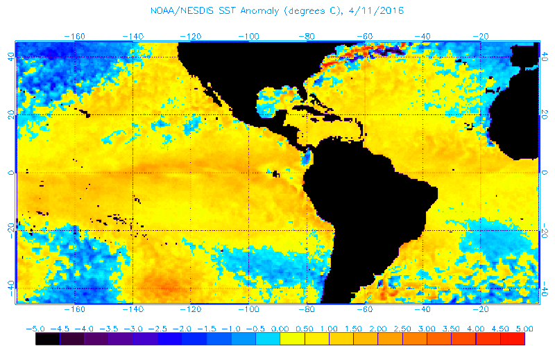
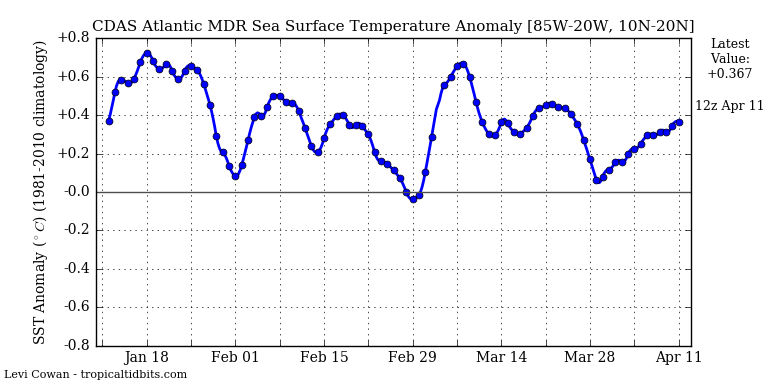
The MDR warmed up fairly nice during the past 10 days or so, thanks to a more neutral to negative NAO. Question is will it maintain the current warmth or will those colder anomalies along the African coast spread westward during the upcoming weeks.
0 likes
Re: 2016 indicators: Instability / SST's / MSLP / Steering / Sal
TheStormExpert wrote:Alyono wrote:Looking a bit closer at the latest EC, Hawaii may be the most at risk part of the USA this year. Even slightly more than the Gulf
Hawaii may be more at risk than usual this upcoming season once again, but their landfall risk remains on the low side IMO due to the typical Hawaiian Island Shear that protects them for the most part.(Take Iselle for example)
The shear was largely nonexistent last year. The storms (aside from Hilda which was the one time shear was present) simply missed.
The greatest TC density according to the EC will be east of Hawaii. If I had to guess, they would be at risk of an east hit. Waters look as if they will be very warm this year east of HI
0 likes
-
Kingarabian

- S2K Supporter
- Posts: 16355
- Joined: Sat Aug 08, 2009 3:06 am
- Location: Honolulu, Hawaii
Re: 2016 indicators: Instability / SST's / MSLP / Steering / Sal
Alyono wrote:TheStormExpert wrote:Alyono wrote:Looking a bit closer at the latest EC, Hawaii may be the most at risk part of the USA this year. Even slightly more than the Gulf
Hawaii may be more at risk than usual this upcoming season once again, but their landfall risk remains on the low side IMO due to the typical Hawaiian Island Shear that protects them for the most part.(Take Iselle for example)
The shear was largely nonexistent last year. The storms (aside from Hilda which was the one time shear was present) simply missed.
The greatest TC density according to the EC will be east of Hawaii. If I had to guess, they would be at risk of an east hit. Waters look as if they will be very warm this year east of HI
As a resident of Hawaii, 2015 kept me on my toes more than I would've liked. We were just so lucky all those major hurricanes missed Hawaii, especially after global models kept modeling Hawaii hits run after run, storm after storm.
Thankfully that MLS kept most storms weak until they passed Hawaii.
0 likes
RIP Kobe Bryant
-
Hurricaneman

- Category 5
- Posts: 7404
- Age: 45
- Joined: Tue Aug 31, 2004 3:24 pm
- Location: central florida
Re: 2016 indicators: Instability / SST's / MSLP / Steering / Sal
The more I look at it this year could be similar to 2004 with a warmer than normal EPAC MDR which surpressed activity until around August where the first named storm was born and then came the barage of storms but that could have been an effect of the really warm Atlantic counteracting that but this is my extreme high side possibility and 1992 is my low side anomaly season as it was a below average season due to higher than normal SSTAs in the EPAC MDR but the difference with 1992 is the -AMO which in itself might have caused the shear to be higher due to temperature differences between the EPAC MDR and the Atlantic MDR and less heat to be used for tropical cyclones
Forum rules
The posts in this forum are NOT official forecast and should not be used as such. They are just the opinion of the poster and may or may not be backed by sound meteorological data. They are NOT endorsed by any professional institution or storm2k.org. For official information, please refer to the NHC and NWS products.
0 likes
-
TheStormExpert
Re: 2016 indicators: Instability / SST's / MSLP / Steering / Sal
Hurricaneman wrote:The more I look at it this year could be similar to 2004 with a warmer than normal EPAC MDR which surpressed activity until around August where the first named storm was born and then came the barage of storms but that could have been an effect of the really warm Atlantic counteracting that but this is my extreme high side possibility and 1992 is my low side anomaly season as it was a below average season due to higher than normal SSTAs in the EPAC MDR but the difference with 1992 is the -AMO which in itself might have caused the shear to be higher due to temperature differences between the EPAC MDR and the Atlantic MDR and less heat to be used for tropical cyclones
Forum rules
The posts in this forum are NOT official forecast and should not be used as such. They are just the opinion of the poster and may or may not be backed by sound meteorological data. They are NOT endorsed by any professional institution or storm2k.org. For official information, please refer to the NHC and NWS products.
2004 was a Modoki El Niño for one, this upcoming season is looking like we will see a moderate La Niña.
0 likes
-
Yellow Evan

- Professional-Met

- Posts: 16232
- Age: 27
- Joined: Fri Jul 15, 2011 12:48 pm
- Location: Henderson, Nevada/Honolulu, HI
- Contact:
Re: 2016 indicators: Instability / SST's / MSLP / Steering / Sal
Levi Cowan @TropicalTidbits 3h3 hours ago
Substantial cooling beginning in eastern equatorial Pacific. This did not happen following 1983 and 1998 El Ninos.
Substantial cooling beginning in eastern equatorial Pacific. This did not happen following 1983 and 1998 El Ninos.
0 likes
Re: 2016 indicators: Instability / SST's / MSLP / Steering / Sal
That cooling is not that significant. The waters to the north are still scorching. This is likely to continue through the 2016 season.
EPAC wins out again
EPAC wins out again
0 likes
Re: 2016 indicators: Instability / SST's / MSLP / Steering / Sal
Levi Cowin might be up to something here because one thing to keep in mind is that Nino 1+2 stayed very warm during the heart of the hurricane season during '83 eventhough Nino 3.4 started cooling down.
IMO when Nino 1+2 stays a good 1+ deg C above normal during the heart of the hurricane season it stays fairly quite most times in the Atlantic basin if Nino 3.4 is neutral or into a cool neutral phase.
1998 Hurricane season didn't got going until late August into September as finally Nino 1+2 started cooling down during that period.
Code: Select all
YR MON  NINO1+2   ANOM   NINO3    ANOM   NINO4    ANOM NINO3.4    ANOM
1982   1   24.29   -0.17   25.87    0.24   28.30    0.00   26.72    0.15
1982   2   25.49   -0.58   26.38    0.01   28.21    0.11   26.70   -0.02
1982   3   25.21   -1.31   26.98   -0.16   28.41    0.22   27.20   -0.02
1982   4   24.50   -0.97   27.68    0.18   28.92    0.42   28.02    0.24
1982   5   23.97   -0.23   27.79    0.71   29.49    0.70   28.54    0.69
1982   6   22.89    0.07   27.46    1.03   29.76    0.92   28.75    1.10
1982   7   22.47    0.87   26.44    0.82   29.38    0.58   28.10    0.88
1982   8   21.75    1.10   26.15    1.16   29.04    0.36   27.93    1.11
1982   9   21.80    1.44   26.52    1.67   29.16    0.47   28.11    1.39
1982  10   22.94    2.12   27.11    2.19   29.38    0.72   28.64    1.95
1982  11   24.59    3.00   27.62    2.64   29.23    0.60   28.81    2.16
1982  12   26.13    3.34   28.39    3.25   29.15    0.66   29.21    2.64
1983   1   27.42    2.96   28.92    3.29   29.00    0.70   29.36    2.79
1983   2   28.09    2.02   28.92    2.55   28.79    0.69   29.13    2.41
1983   3   28.68    2.16   29.10    1.96   28.76    0.57   29.03    1.81
1983   4   28.56    3.09   29.12    1.62   28.85    0.35   28.91    1.13
1983   5   28.19    3.99   28.97    1.89   29.08    0.29   28.89    1.04
1983   6   27.44    4.62   28.15    1.72   28.88    0.04   28.24    0.59
1983   7   25.95    4.35   26.62    1.00   28.65   -0.15   27.07   -0.15
1983   8   23.78    3.13   25.87    0.88   28.38   -0.30   26.53   -0.29
1983   9   22.24    1.88   25.24    0.39   28.23   -0.46   26.44   -0.28
1983  10   21.86    1.04   24.61   -0.31   27.75   -0.91   25.87   -0.82
1983  11   21.90    0.31   24.17   -0.81   27.76   -0.87   25.58   -1.07
1983  12   23.01    0.22   24.44   -0.70   27.82   -0.67   25.59   -0.98
0 likes
-
Hurricaneman
- Category 5
- Posts: 7404
- Age: 45
- Joined: Tue Aug 31, 2004 3:24 pm
- Location: central florida
Re: 2016 indicators: Instability / SST's / MSLP / Steering / Sal
If one looks at 1983 it really didn't become favorable until November which is why that year was as slow as it was and the ENSO 1 2 regions basically shut down the entire season basically.
We're not going to have that in 2016 and I really can't find any year similar looking to this year as far as the SSTAs in both the atlantic and EPAC which may make any forecast really hard for anyone, it could be a 16\10\5 year, 8\4\1 type year or a 14\2\0 year. Anything is possible
The posts in this forum are NOT official forecast and should not be used as such. They are just the opinion of the poster and may or may not be backed by sound meteorological data. They are NOT endorsed by any professional institution or storm2k.org. For official information, please refer to the NHC and NWS products
0 likes
-
cycloneye

- Admin

- Posts: 149405
- Age: 69
- Joined: Thu Oct 10, 2002 10:54 am
- Location: San Juan, Puerto Rico
Re: 2016 indicators: Instability / SST's / MSLP / Steering / Sal
Interesting comparisons from 2016 to the 80,s sst,s that JB has.
BigJoeBastardi · 6m6 minutes ago
You can clearly see that the sst today ( below) is much warmer than what we were in the 80s ( string above)

BigJoeBastardi · 6m6 minutes ago
You can clearly see that the sst today ( below) is much warmer than what we were in the 80s ( string above)
0 likes
Visit the Caribbean-Central America Weather Thread where you can find at first post web cams,radars
and observations from Caribbean basin members Click Here
and observations from Caribbean basin members Click Here
-
HURRICANELONNY
- Category 5
- Posts: 1392
- Joined: Wed May 07, 2003 6:48 am
- Location: HOLLYWOOD.FL
Re: 2016 indicators: Instability / SST's / MSLP / Steering / Sal
That cold pool that has been in the North Atlantic for years could be a wild card in the tropics this year:
https://www.wunderground.com/blog/JeffM ... nt-go-away
https://www.wunderground.com/blog/JeffM ... nt-go-away
0 likes
hurricanelonny
Re: 2016 indicators: Instability / SST's / MSLP / Steering / Sal
HURRICANELONNY wrote:That cold pool that has been in the North Atlantic for years could be a wild card in the tropics this year:
https://www.wunderground.com/blog/JeffM ... nt-go-away
Arguably the biggest influence that cold water has is the Azores/Bermuda high. When the waters are colder than normal the Icelandic low tends to be stronger than normal (+NAO) thus it will strengthen the Azores/Bermuda high creating higher than normal pressures across the lower and mid latitudes of the open Atlantic. When the opposite occurs with warm waters there (-NAO) the adjacent high is significantly weaker leading to lower than normal pressures and likely more activity. The higher than normal pressure seasonal forecasts from the ECMWF really began about 2013 when the waters there started getting colder.
0 likes
The above post and any post by Ntxw is NOT an official forecast and should not be used as such. It is just the opinion of the poster and may or may not be backed by sound meteorological data. It is NOT endorsed by any professional institution including Storm2k. For official information, please refer to NWS products.
Help support Storm2K!
Help support Storm2K!
Who is online
Users browsing this forum: Ulf and 163 guests