Seasonal Indicators (Beyond Day 16): Instability / SST's / MSLP / Steering / Sal
Moderator: S2k Moderators
Forum rules

The posts in this forum are NOT official forecasts and should not be used as such. They are just the opinion of the poster and may or may not be backed by sound meteorological data. They are NOT endorsed by any professional institution or STORM2K. For official information, please refer to products from the National Hurricane Center and National Weather Service.


Re: 2016 indicators: Instability / SST's / MSLP / Steering / Sal
Its now May. The 30/60/90 day forecasts and modelling become a little better though far from reliable. Still conditions around this time can be a precursor as the seasonal shift matures across the NHEM for warmer months. Overall though not perfect, this year's signals are better than the past two at least so I would say an overall bigger seasons than those. Hyper season? I wouldn't call for that yet, when you predict extremes on both ends ahead of time they usually don't work out MOST of the time. The bell curve rule for odds anyway.
0 likes
The above post and any post by Ntxw is NOT an official forecast and should not be used as such. It is just the opinion of the poster and may or may not be backed by sound meteorological data. It is NOT endorsed by any professional institution including Storm2k. For official information, please refer to NWS products.
Help support Storm2K!
-
SFLcane

- S2K Supporter

- Posts: 10281
- Age: 48
- Joined: Sat Jun 05, 2010 1:44 pm
- Location: Lake Worth Florida
Re: 2016 indicators: Instability / SST's / MSLP / Steering / Sal
Ntxw wrote:Its now May. The 30/60/90 day forecasts and modelling become a little better though far from reliable. Still conditions around this time can be a precursor as the seasonal shift matures across the NHEM for warmer months. Overall though not perfect, this year's signals are better than the past two at least so I would say an overall bigger seasons than those. Hyper season? I wouldn't call for that yet, when you predict extremes on both ends ahead of time they usually don't work out MOST of the time. The bell curve rule for odds anyway.
I'am liking your talk Ntxw I concur on this season being busier then last few years " which " may come as a surprise to many since we have forgotten what a bonified cane really looks like in Atlantic. We shall see
0 likes
-
TexasBreeze
- Tropical Depression

- Posts: 81
- Joined: Mon Jul 07, 2014 12:50 pm
Re: 2016 indicators: Instability / SST's / MSLP / Steering / Sal
For whatever forms out there which may be a few more systems than previous seasons, the consistent trough in the west and ridge southeast Conus favors the Carrib and central/west GOM for possible steering...so far....
0 likes
-
WeatherEmperor
- S2K Supporter
- Posts: 4806
- Age: 42
- Joined: Thu Sep 04, 2003 2:54 pm
- Location: South Florida
Re: 2016 indicators: Instability / SST's / MSLP / Steering / Sal
+1 on this. So many people say sst this and sst that...but its the overall atmosphere that will ultimately decide how active the Atlantic is. I mentioned 1983 before as an analog not because of the Enso temp profiles but because of the overall atmospheric behavior. I feel many overlook this unfortunately.
We have many factors to consider. We have instability, sst temps, wind shear, Sal, Enso, high pressure dominating the Mdr etc. All of these have to play in concert to have a very active season. For example, people have to realize that you cannot have warm atlantic sst and very high pressures in the Mdr and expect a very active season. Everything has to work together.
We have many factors to consider. We have instability, sst temps, wind shear, Sal, Enso, high pressure dominating the Mdr etc. All of these have to play in concert to have a very active season. For example, people have to realize that you cannot have warm atlantic sst and very high pressures in the Mdr and expect a very active season. Everything has to work together.
Darvince wrote:So far the +PDO and the strong -SOI still show that the atmosphere doesn't want to go into niña mode, so I'd doubt that we're going to have a strong, fast oncoming niña. Perhaps a weak one between -0.5C and -1.0C.
0 likes
-
SFLcane
- S2K Supporter
- Posts: 10281
- Age: 48
- Joined: Sat Jun 05, 2010 1:44 pm
- Location: Lake Worth Florida
Re: 2016 indicators: Instability / SST's / MSLP / Steering / Sal
WeatherEmperor wrote:+1 on this. So many people say sst this and sst that...but its the overall atmosphere that will ultimately decide how active the Atlantic is. I mentioned 1983 before as an analog not because of the Enso temp profiles but because of the overall atmospheric behavior. I feel many overlook this unfortunately.
We have many factors to consider. We have instability, sst temps, wind shear, Sal, Enso, high pressure dominating the Mdr etc. All of these have to play in concert to have a very active season. For example, people have to realize that you cannot have warm atlantic sst and very high pressures in the Mdr and expect a very active season. Everything has to work together.Darvince wrote:So far the +PDO and the strong -SOI still show that the atmosphere doesn't want to go into niña mode, so I'd doubt that we're going to have a strong, fast oncoming niña. Perhaps a weak one between -0.5C and -1.0C.
If that happens most development might get shifted into Carib and gulf were instability for first since I can remember Is up.
0 likes
-
TheStormExpert
Re: 2016 indicators: Instability / SST's / MSLP / Steering / Sal
TexasBreeze wrote:For whatever forms out there which may be a few more systems than previous seasons, the consistent trough in the west and ridge southeast Conus favors the Carrib and central/west GOM for possible steering...so far....
Yeah, this is something we really need to monitor throughout the coming months as this pattern has seem to be mostly present since about this time last Spring. I always wonder if the so-called "Godzilla" El Niño we are coming out of has anything to do with this pattern shift to more West Coast Troughiness, and East Coast Ridging?
0 likes

Re: 2016 indicators: Instability / SST's / MSLP / Steering / Sal
WeatherEmperor wrote:+1 on this. So many people say sst this and sst that...but its the overall atmosphere that will ultimately decide how active the Atlantic is. I mentioned 1983 before as an analog not because of the Enso temp profiles but because of the overall atmospheric behavior. I feel many overlook this unfortunately.
We have many factors to consider. We have instability, sst temps, wind shear, Sal, Enso, high pressure dominating the Mdr etc. All of these have to play in concert to have a very active season. For example, people have to realize that you cannot have warm atlantic sst and very high pressures in the Mdr and expect a very active season. Everything has to work together.Darvince wrote:So far the +PDO and the strong -SOI still show that the atmosphere doesn't want to go into niña mode, so I'd doubt that we're going to have a strong, fast oncoming niña. Perhaps a weak one between -0.5C and -1.0C.
OK, so lets look at the atmosphere over the Caribbean right now as I think we may see early development there. I am not looking at the eastern Atlantic right now as it is usually a non issue over the next few weeks.
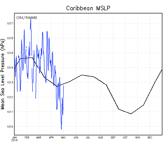
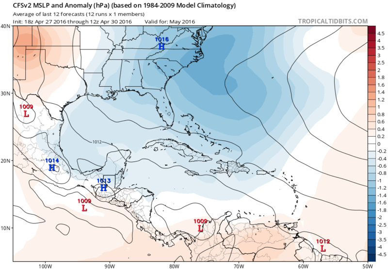
MSLP has been running below average for the past 3 weeks or so, CFSv2 forecasts average to below average MSLP through next month.
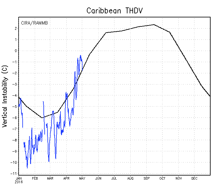
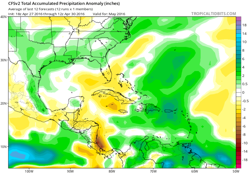
Instability has been running above average over the last couple of weeks, CFSv2 is forecasting a continuing wet pattern for most of the Caribbean next month.
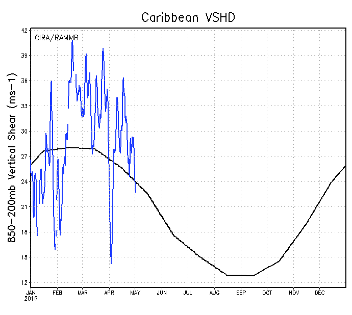
Windshear has been running above average for the past few weeks but is forecasted by the latest weekly CFSv2 forecast to become below average next month.
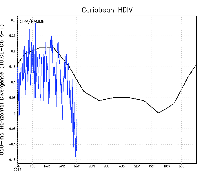
The most interesting part is that H85 divergence has been running well below average.
Last edited by NDG on Sun May 01, 2016 9:09 pm, edited 1 time in total.
0 likes
-
AnnularCane

- S2K Supporter
- Posts: 2961
- Joined: Thu Jun 08, 2006 9:18 am
- Location: Wytheville, VA
-
gatorcane

- S2K Supporter
- Posts: 23708
- Age: 48
- Joined: Sun Mar 13, 2005 3:54 pm
- Location: Boca Raton, FL
Re: 2016 indicators: Instability / SST's / MSLP / Steering / Sal
NDG wrote:WeatherEmperor wrote:+1 on this. So many people say sst this and sst that...but its the overall atmosphere that will ultimately decide how active the Atlantic is. I mentioned 1983 before as an analog not because of the Enso temp profiles but because of the overall atmospheric behavior. I feel many overlook this unfortunately.
We have many factors to consider. We have instability, sst temps, wind shear, Sal, Enso, high pressure dominating the Mdr etc. All of these have to play in concert to have a very active season. For example, people have to realize that you cannot have warm atlantic sst and very high pressures in the Mdr and expect a very active season. Everything has to work together.Darvince wrote:So far the +PDO and the strong -SOI still show that the atmosphere doesn't want to go into niña mode, so I'd doubt that we're going to have a strong, fast oncoming niña. Perhaps a weak one between -0.5C and -1.0C.
OK, so lets look at the atmosphere over the Caribbean right now as I think we may see early development there. I am not looking at the eastern Atlantic right now as it is usually a non issue over the next few weeks.
MSLP has been running below average for the past 3 weeks or so, CFSv2 forecasts average to below average MSLP through next month.
http://rammb.cira.colostate.edu/project ... r_MSLP.gif
http://www.tropicaltidbits.com/analysis ... watl_1.png
Instability has been running above average over the last couple of weeks, CFSv2 is forecasting a continuing wet pattern for most of the Caribbean next month.
http://rammb.cira.colostate.edu/project ... r_THDV.gif
http://www.tropicaltidbits.com/analysis ... watl_1.png
Windshear has been running above average for the past few weeks but is forecasted by the latest weekly CFSv2 forecast to become below average next month.
http://rammb.cira.colostate.edu/project ... r_VSHD.gif
http://www.tropicaltidbits.com/analysis ... watl_5.png
The most interesting part is that H85 divergence has been running well below average.
http://rammb.cira.colostate.edu/project ... r_HDIV.gif
Nice graphics, also super long-range CFS model showing lower MSLPs lifting up from Western Caribbean and up over Florida end-of-month (graphic below is May 28th). Just maybe some pre-season activity could get going in the Western Caribbean towards end-of-month, we shall see:

0 likes
Re: 2016 indicators: Instability / SST's / MSLP / Steering / Sal
AnnularCane wrote:What is H85 divergence?
Divergence at 850mb, contrary to convergence & confluence. So in another words sinking air near the surface is below average over the Caribbean.
0 likes
-
Hurricaneman

- Category 5

- Posts: 7404
- Age: 45
- Joined: Tue Aug 31, 2004 3:24 pm
- Location: central florida
Re: 2016 indicators: Instability / SST's / MSLP / Steering / Sal
Wouldn't be surprised if we see a late May or June hurricane this year based on what the models are seeing but it also could be just noise
0 likes


-
TheStormExpert
Re: 2016 indicators: Instability / SST's / MSLP / Steering / Sal
Hurricaneman wrote:Wouldn't be surprised if we see a late May or June hurricane this year based on what the models are seeing but it also could be just noise
What models are you looking at?
0 likes


Re: 2016 indicators: Instability / SST's / MSLP / Steering / Sal
TheStormExpert wrote:Hurricaneman wrote:Wouldn't be surprised if we see a late May or June hurricane this year based on what the models are seeing but it also could be just noise
What models are you looking at?
Think he's referring to the general conditions that NDG posted above, like the lower shear and pressures depicted on the CFS. A few stray lows are popping up at max range on the GFS but no legitimate phantoms yet.
0 likes
-
SFLcane
- S2K Supporter
- Posts: 10281
- Age: 48
- Joined: Sat Jun 05, 2010 1:44 pm
- Location: Lake Worth Florida
Re: 2016 indicators: Instability / SST's / MSLP / Steering / Sal
Woah updated CFS for August and September showing Hostile conditions basin wide. Then again what's new for this basin 
0 likes
-
gatorcane
- S2K Supporter
- Posts: 23708
- Age: 48
- Joined: Sun Mar 13, 2005 3:54 pm
- Location: Boca Raton, FL
Re: 2016 indicators: Instability / SST's / MSLP / Steering / Sal
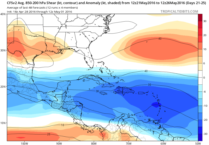
GFS continues to advertise much lower than normal shear over the Caribbean in the long-range which would be able to support some pre-season development. In fact, if this comes to fruition (a big if), I don't think we saw shear this low across the Caribbean the entire season during last year with the Godzilla El Nino. So perhaps an early indication the upper-level environment will be considerably more conducive this season to support Caribbean development (which is what you would expect given no El Nino conditions).

0 likes

Re: 2016 indicators: Instability / SST's / MSLP / Steering / Sal
http://www.cpc.ncep.noaa.gov/products/C ... e3Sea.html
CFS has drier than normal conditions forecast for the western Caribbean in Aug-Oct with increased precip for the EPAC
This is going to be an active EPAC season. ALL dynamical signals favor this
CFS has drier than normal conditions forecast for the western Caribbean in Aug-Oct with increased precip for the EPAC
This is going to be an active EPAC season. ALL dynamical signals favor this
0 likes
-
SFLcane
- S2K Supporter
- Posts: 10281
- Age: 48
- Joined: Sat Jun 05, 2010 1:44 pm
- Location: Lake Worth Florida
Re: 2016 indicators: Instability / SST's / MSLP / Steering / Sal
Alyono wrote:http://www.cpc.ncep.noaa.gov/products/CFSv2/htmls/glbPrece3Sea.html
CFS has drier than normal conditions forecast for the western Caribbean in Aug-Oct with increased precip for the EPAC
This is going to be an active EPAC season. ALL dynamical signals favor this
Alyono we get it maybe we should skip the season? Atlantic=fail
0 likes
-
WPBWeather

- S2K Supporter
- Posts: 535
- Age: 67
- Joined: Thu Jul 18, 2013 12:33 pm
Re: 2016 indicators: Instability / SST's / MSLP / Steering / Sal
SFLcane wrote:Alyono wrote:http://www.cpc.ncep.noaa.gov/products/CFSv2/htmls/glbPrece3Sea.html
CFS has drier than normal conditions forecast for the western Caribbean in Aug-Oct with increased precip for the EPAC
This is going to be an active EPAC season. ALL dynamical signals favor this
Alyono we get it maybe we should skip the season? Atlantic=fail
Come on now. This is getting silly. One ProMet has an opinion on one model way far out. Other ProMets disagree or don't use dynamical modeling as live or die. We shall see how the season progresses.
0 likes
-
wxman57

- Moderator-Pro Met

- Posts: 23173
- Age: 68
- Joined: Sat Jun 21, 2003 8:06 pm
- Location: Houston, TX (southwest)
Re: 2016 indicators: Instability / SST's / MSLP / Steering / Sal
Alyono believes that above-normal East Pac SSTs NORTH of the La Nina area may result in enhanced TC activity there (offshore Mexico), resulting in more sinking air and shear across the Gulf/Caribbean. Thus, he's forecasting a rather quiet (numbers-wise) season. I don't believe the warm East Pac water north of the Equator will be as much of a factor, and that the Gulf/Caribbean will be open for business in 2016. Prime development region may be from the western Caribbean to the Gulf this year (my opinion). Even in Alyono's quite season forecast, he acknowledges that analog seasons suggest significant Gulf hurricane activity (as in 1983, 1992).
0 likes
Who is online
Users browsing this forum: Bing [Bot] and 176 guests