Cooler than normal waters in the MDR to about 60W above 15N which means if systems stay below 15N they could develop in the MDR but looks like the Caribbean and GOM may end up well above normal which is a positive for development in those areas so based on that expect a lot of sub tropical Atlantic development and west of 55 to be quite active and possibly one big MDR system but not much more in the MDR
PS: watch the east coast also as the area east of the bahamas look to be primed for some storms
The posts in this forum are NOT official forecast and should not be used as such. They are just the opinion of the poster and may or may not be backed by sound meteorological data. They are NOT endorsed by any professional institution or storm2k.org. For official information, please refer to the NHC and NWS products.
Seasonal Indicators (Beyond Day 16): Instability / SST's / MSLP / Steering / Sal
Moderator: S2k Moderators
Forum rules

The posts in this forum are NOT official forecasts and should not be used as such. They are just the opinion of the poster and may or may not be backed by sound meteorological data. They are NOT endorsed by any professional institution or STORM2K. For official information, please refer to products from the National Hurricane Center and National Weather Service.
-
Hurricaneman

- Category 5

- Posts: 7404
- Age: 45
- Joined: Tue Aug 31, 2004 3:24 pm
- Location: central florida
-
wxman57

- Moderator-Pro Met

- Posts: 23173
- Age: 68
- Joined: Sat Jun 21, 2003 8:06 pm
- Location: Houston, TX (southwest)
Re: 2016 indicators: Instability / SST's / MSLP / Steering / Sal
tarheelprogrammer wrote:Do they normally start rolling off this early in the year?
Yes, it's normal.
0 likes
-
tarheelprogrammer

- S2K Supporter

- Posts: 1793
- Joined: Mon Mar 28, 2016 9:25 pm
- Location: Raleigh, NC area (Garner, NC)
Re: 2016 indicators: Instability / SST's / MSLP / Steering / Sal
wxman57 wrote:tarheelprogrammer wrote:Do they normally start rolling off this early in the year?
Yes, it's normal.
Thanks I was thinking it was being pointed out because it wasn't. Stupid me lol.
0 likes
My posts are not official forecasts. They are just my opinion and may or may not be backed by sound meteorological data. They are NOT endorsed by any professional institution or storm2k.org. For official information, please refer to the NHC and NWS products.
-
Hurricaneman
- Category 5
- Posts: 7404
- Age: 45
- Joined: Tue Aug 31, 2004 3:24 pm
- Location: central florida
Re: 2016 indicators: Instability / SST's / MSLP / Steering / Sal
Is it me or is the modeling predicting a weak or small Azores high {weak as in GFS small as in Euro}
if so what would a weaker Azores high mean for the hurricane season
The posts in this forum are NOT official forecast and should not be used as such. They are just the opinion of the poster and may or may not be backed by sound meteorological data. They are NOT endorsed by any professional institution or storm2k.org. For official information, please refer to the NHC and NWS products.
0 likes
-
Huckster

- Category 1

- Posts: 394
- Age: 44
- Joined: Fri Aug 13, 2004 2:33 am
- Location: Baton Rouge, LA
- Contact:
Re: 2016 indicators: Instability / SST's / MSLP / Steering / Sal
Hurricaneman wrote:Is it me or is the modeling predicting a weak or small Azores high {weak as in GFS small as in Euro}
if so what would a weaker Azores high mean for the hurricane season
The posts in this forum are NOT official forecast and should not be used as such. They are just the opinion of the poster and may or may not be backed by sound meteorological data. They are NOT endorsed by any professional institution or storm2k.org. For official information, please refer to the NHC and NWS products.
A weaker Azores High could result in weaker trade winds. A lack of screaming easterly low level winds is one of the ingredients necessary for tropical waves to close off a surface low. Usually, but not always, it is difficult for tropical waves to develop if they are racing westward at 30 kts or more. This is one reason that waves which have not developed into cyclones before reaching the eastern Caribbean often don't do so until much farther west, near or past Hispaniola (assuming they don't plow over it while trying to organize). That's why the Bahamas, western Caribbean, and Gulf tend to be better locations for TC formation.
0 likes
God lufode middaneard swa þæt he sealde his ancennedan Sunu, þæt nan ne forwurðe þe on hine gelyfð, ac hæbbe þæt ece lif. - Old English/Anglo-Saxon, John 3:16


Re: 2016 indicators: Instability / SST's / MSLP / Steering / Sal
Yeah, while unsure of cause or effect, the strength of the Azores/Bermuda high is reflective of overall higher or lower than normal pressures along with those trades.
0 likes
The above post and any post by Ntxw is NOT an official forecast and should not be used as such. It is just the opinion of the poster and may or may not be backed by sound meteorological data. It is NOT endorsed by any professional institution including Storm2k. For official information, please refer to NWS products.
Help support Storm2K!
-
Janie2006

- Category 5
- Posts: 1329
- Joined: Mon Sep 18, 2006 3:28 pm
- Location: coastal Ms aka home of the hurricanes
Re: 2016 indicators: Instability / SST's / MSLP / Steering / Sal
I should think that a weaker Azores/Bermuda high (well, I suppose it'd be more toward the Azores if it were weaker this season) would also lead to some storms recurving earlier than they normally might, depending on location of development, of course.
0 likes
-
gatorcane

- S2K Supporter
- Posts: 23708
- Age: 48
- Joined: Sun Mar 13, 2005 3:54 pm
- Location: Boca Raton, FL
Re: 2016 indicators: Instability / SST's / MSLP / Steering / Sal
The waters around the Bahamas and Florida have warmed dramatically just in the past couple of weeks and have gone to below normal to above normal:


0 likes

Re: 2016 indicators: Instability / SST's / MSLP / Steering / Sal
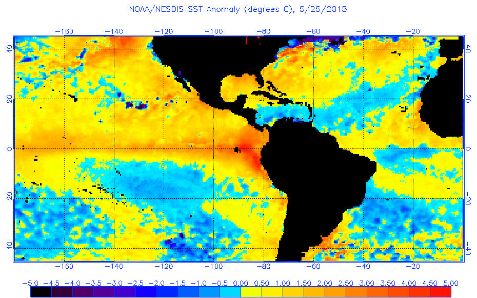
To along with the post above, SSTs are much warmer so far across the MDR and Caribbean than this same time last year.
0 likes
-
SFLcane

- S2K Supporter
- Posts: 10281
- Age: 48
- Joined: Sat Jun 05, 2010 1:44 pm
- Location: Lake Worth Florida
Re: 2016 indicators: Instability / SST's / MSLP / Steering / Sal
Warm MDR??? not sure what you guys are looking at? drastic cooling 

0 likes
Re: 2016 indicators: Instability / SST's / MSLP / Steering / Sal
SFLcane wrote:Warm MDR??? not sure what you guys are looking at? drastic cooling
http://www.tropicaltidbits.com/analysis ... pics_1.png
Oh please, CDAS always seems to suffer from bipolar disorder from day to day, give it a few days it will show contrary the opposite.
0 likes
-
tarheelprogrammer
- S2K Supporter
- Posts: 1793
- Joined: Mon Mar 28, 2016 9:25 pm
- Location: Raleigh, NC area (Garner, NC)
Re: 2016 indicators: Instability / SST's / MSLP / Steering / Sal
Here guys let me add more confusion.

0 likes
My posts are not official forecasts. They are just my opinion and may or may not be backed by sound meteorological data. They are NOT endorsed by any professional institution or storm2k.org. For official information, please refer to the NHC and NWS products.
-
SFLcane
- S2K Supporter
- Posts: 10281
- Age: 48
- Joined: Sat Jun 05, 2010 1:44 pm
- Location: Lake Worth Florida
Re: 2016 indicators: Instability / SST's / MSLP / Steering / Sal
NDG wrote:SFLcane wrote:Warm MDR??? not sure what you guys are looking at? drastic cooling
http://www.tropicaltidbits.com/analysis ... pics_1.png
Oh please, CDAS always seems to suffer from bipolar disorder from day to day, give it a few days it will show contrary the opposite.
Persistence of subtropical high will favor further cooling of eastern atl sst's
0 likes
-
tarheelprogrammer
- S2K Supporter
- Posts: 1793
- Joined: Mon Mar 28, 2016 9:25 pm
- Location: Raleigh, NC area (Garner, NC)
Re: 2016 indicators: Instability / SST's / MSLP / Steering / Sal
SFLcane wrote:NDG wrote:SFLcane wrote:Warm MDR??? not sure what you guys are looking at? drastic cooling
http://www.tropicaltidbits.com/analysis ... pics_1.png
Oh please, CDAS always seems to suffer from bipolar disorder from day to day, give it a few days it will show contrary the opposite.
Persistence of subtropical high will favor further cooling of eastern atl sst's
Quick question will one or two degrees below normal affect hurricane season drastically?
0 likes
My posts are not official forecasts. They are just my opinion and may or may not be backed by sound meteorological data. They are NOT endorsed by any professional institution or storm2k.org. For official information, please refer to the NHC and NWS products.

-
SFLcane
- S2K Supporter
- Posts: 10281
- Age: 48
- Joined: Sat Jun 05, 2010 1:44 pm
- Location: Lake Worth Florida
Re: 2016 indicators: Instability / SST's / MSLP / Steering / Sal
That cold water in North Atl still looks ugly for a busy season per phil k.
0 likes

Re: 2016 indicators: Instability / SST's / MSLP / Steering / Sal
SFLcane wrote:NDG wrote:SFLcane wrote:Warm MDR??? not sure what you guys are looking at? drastic cooling
http://www.tropicaltidbits.com/analysis ... pics_1.png
Oh please, CDAS always seems to suffer from bipolar disorder from day to day, give it a few days it will show contrary the opposite.
Persistence of subtropical high will favor further cooling of eastern atl sst's
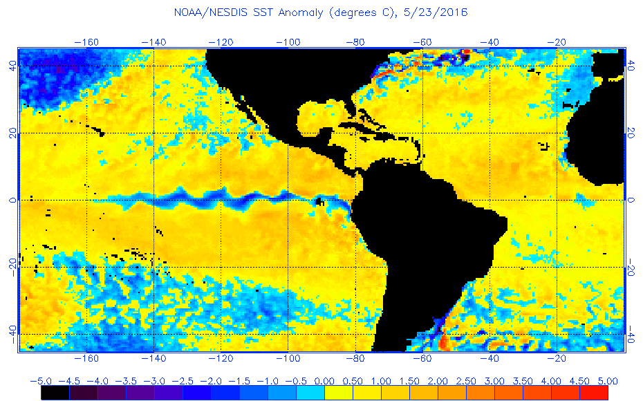
All I am saying is that current SSTs at MDR is warmer than this same time last year. Your CDAS image shows cooling over the past 7 days, but not that it is as cool as last year.
0 likes
Re: 2016 indicators: Instability / SST's / MSLP / Steering / Sal
Here is a more current image, from the same site.
BTW, your image shows a bunch of years right by the temp anomaly index which tells me that it was just an average of analog years that somebody put up not that it was a current true SST anomolay for the Atlantic.

0 likes
-
tarheelprogrammer
- S2K Supporter
- Posts: 1793
- Joined: Mon Mar 28, 2016 9:25 pm
- Location: Raleigh, NC area (Garner, NC)
Re: 2016 indicators: Instability / SST's / MSLP / Steering / Sal
This has been an interesting argument over SSTs. The map I posted does show it is pretty much warm all across the Atlantic and even areas that are below normal it is not a huge amount in most spots.
0 likes
My posts are not official forecasts. They are just my opinion and may or may not be backed by sound meteorological data. They are NOT endorsed by any professional institution or storm2k.org. For official information, please refer to the NHC and NWS products.
Who is online
Users browsing this forum: Google Adsense [Bot] and 99 guests