
Area of Disturbed Weather North of Eastern Cuba - (Invest 91L is up)
Moderator: S2k Moderators
Forum rules

The posts in this forum are NOT official forecasts and should not be used as such. They are just the opinion of the poster and may or may not be backed by sound meteorological data. They are NOT endorsed by any professional institution or STORM2K. For official information, please refer to products from the National Hurricane Center and National Weather Service.
-
gatorcane

- S2K Supporter

- Posts: 23708
- Age: 48
- Joined: Sun Mar 13, 2005 3:54 pm
- Location: Boca Raton, FL
Area of Disturbed Weather North of Eastern Cuba - (Invest 91L is up)
Models show a trough/weak low forming in this area and generally moving slowly NW or WNW in the general direction of the SE United States.
0 likes
-
floridasun78
- Category 5

- Posts: 3755
- Joined: Sun May 17, 2009 10:16 pm
- Location: miami fl
Re: 2016 Global Model Runs Discussion
here miami nws saying LONG TERM...
The slightly drier air mass will remain in place Thursday with
only low rain chances over the southern third of the area. The
pocket of lower heights and colder air aloft over the Bahamas
is likely to begin to develop a surface reflection by Thursday,
either in the form of an inverted trough or weak surface low. As
the southeast U.S. ridge begins to weaken and move east by the
weekend, this system will begin to feel the influence of a
negatively tilted upper trough ejecting out of the Plains,
inducing a general movement toward the northwest. This will keep
South Florida generally on the drier side of the system. However,
the surface ridge breaking down should allow the old boundary to
wash out, allowing the return of deeper moisture to the area. With
relatively weak gradients over the area, diurnal sea breeze
convection will be the main weather of interest. here what Area Forecast Discussion
Issued by NWS Melbourne, FL FRI-MON...Run to run model differences continue to make this period
challenging, however, the latest guidance seems to have come into
better agreement regarding the expected evolution of the mid and
upper level cutoff low and any surface-related reflection. Both the
GFS and ECMWF have converged on a weak surface low developing east
of the state while gradually moving north toward the Carolinas. This
would keep us on the slightly drier and more subsident side of the
system, tempering overall rain chances through the weekend.
Regardless, sufficient low level moisture will allow for at least
chance PoPs in the forecast through the period.
Area Forecast Discussion
Issued by NWS Wilmington, NC
LONG TERM /FRIDAY THROUGH MONDAY/...
As of 3 AM Tuesday...Uncertainty during the period remains quite
high due to possible development of hybrid low pressure off the
southeast coast late in the week. The GFS has been consistent in
developing this feature the last few days with the CMC and ECMWF
recently jumping on board. So while the medium range guidance is in
agreement that a low or, at the very least, a trough will exist off
the southeast coast at the start of the period the location of this
feature varies significantly, as does its track. The medium range
guidance does agree on the break down of the surface and mid level
ridging later Fri with increasing tropical moisture resulting in an
increase in cloud cover and shower chances for the weekend.
0 likes
-
wxman57

- Moderator-Pro Met

- Posts: 23175
- Age: 68
- Joined: Sat Jun 21, 2003 8:06 pm
- Location: Houston, TX (southwest)
Re: Area of Disturbed Weather North of Eastern Cuba
I think there's a pretty good chance that the Carolinas will be dealing with TD One or TS Bonnie this weekend. Probably not a hurricane. Should make for a nasty Memorial Day weekend for NC through eastern VA and possibly farther north.
0 likes
-
TheStormExpert
Re: Area of Disturbed Weather North of Eastern Cuba
wxman57 wrote:I think there's a pretty good chance that the Carolinas will be dealing with TD One or TS Bonnie this weekend. Probably not a hurricane. Should make for a nasty Memorial Day weekend for NC through eastern VA and possibly farther north.
I know this may be far fetched right now but may I ask what your thoughts on actual wind speed intensities are?
0 likes
-
floridasun78
- Category 5
- Posts: 3755
- Joined: Sun May 17, 2009 10:16 pm
- Location: miami fl
Re: Area of Disturbed Weather North of Eastern Cuba
alot hotels and business alone east coast why now doing long weekend and people book hotel room on beach their pay pretty good for hotel room
0 likes
-
tarheelprogrammer

- S2K Supporter
- Posts: 1793
- Joined: Mon Mar 28, 2016 9:25 pm
- Location: Raleigh, NC area (Garner, NC)
Re: Area of Disturbed Weather North of Eastern Cuba
Kind of a hint of rotation with this area in the last few frames. CMC shows the storm getting together quickly and that is why it is stronger correct? CMC I know is not a great model but it is a model none the less.
0 likes
My posts are not official forecasts. They are just my opinion and may or may not be backed by sound meteorological data. They are NOT endorsed by any professional institution or storm2k.org. For official information, please refer to the NHC and NWS products.
-
cycloneye

- Admin

- Posts: 149505
- Age: 69
- Joined: Thu Oct 10, 2002 10:54 am
- Location: San Juan, Puerto Rico
Re: Area of Disturbed Weather North of Eastern Cuba
The most sure thing apart of what wxman57 said is there will be invest 91L in the next few days. 
0 likes
Visit the Caribbean-Central America Weather Thread where you can find at first post web cams,radars
and observations from Caribbean basin members Click Here
and observations from Caribbean basin members Click Here
-
TheStormExpert
Re: Area of Disturbed Weather North of Eastern Cuba
cycloneye wrote:The most sure thing apart of what wxman57 said is there will be invest 91L in the next few days.
Yep, when wxman57 is on board you know some sort of development at the very least is bound to happen!
0 likes
-
SFLcane

- S2K Supporter
- Posts: 10281
- Age: 48
- Joined: Sat Jun 05, 2010 1:44 pm
- Location: Lake Worth Florida
Re: Area of Disturbed Weather North of Eastern Cuba
Yep 57...invest coming. This system has no baring in what the rest of season holds BUT I just a have a feeling some long nights coming. Rude awaking for most. Now Gimmie an invest!
0 likes
-
TheStormExpert
Re: Area of Disturbed Weather North of Eastern Cuba
SFLcane wrote:Yep 57...invest coming. This system has no baring in what the rest of season holds BUT I just a have a feeling some long nights coming. Rude awaking for most. Now Gimmie an invest!
If the Euro is right there may be yet another storm heading for the SE U.S. from the Caribbean/Bahamas, but that's in the long range and let's first see what happens with this area of interest.
0 likes
-
TheStormExpert
Re: Area of Disturbed Weather North of Eastern Cuba
The 12z Euro barely does much with the first low this weekend but develops another stronger low next Thursday that originates in the Caribbean/Bahamas and heads for the Georgia/SC border or just south of there.

0 likes
-
cycloneye
- Admin
- Posts: 149505
- Age: 69
- Joined: Thu Oct 10, 2002 10:54 am
- Location: San Juan, Puerto Rico
Re: Area of Disturbed Weather North of Eastern Cuba
This is what Dr Jeff Masters discussed in his blog about this.
We're fast approaching the official June 1 start of the Atlantic hurricane season, and we already have an area of concern to watch for possible genesis of a tropical depression during the coming Memorial Day weekend. An area of low pressure is expected to form on Friday near to or a few hundred miles north of the Bahama Islands, and this low has the potential for tropical development as it moves northwest towards the Southeast U.S. coast. Sea Surface Temperatures (SSTs) over the Bahamas are about 28 - 29°C (82 - 84°F), which is 1 - 2°C (1.8 - 3.6°F) above average. These waters are plenty warm enough to support formation of a tropical storm. Phase space diagrams from Florida State University have been consistently showing that this storm will be a symmetric warm core system, which is technical lingo for a storm that is tropical in nature, rather than subtropical or extratropical.
What the models say: a heavy rain threat for the Southeast U.S. coast
In my 2013 blog post, Genesis of New Atlantic Tropical Cyclones: Which Model Should You Trust?, I explained that we have three models that have proven to be fairly reliable for predicting the genesis of tropical depressions up to four days in advance: the American GFS model, the European ECMWF model, and the British UKMET model. Over the past two days, the GFS and European models have been showing the potential for a tropical depression to near or to the north of the Bahamas; the UKMET model has merely shown a tropical disturbance forming. The models have widely differing ideas on how much wind shear might be present, so it is too early to say if this weekend's system is a legitimate threat to develop into a tropical depression. The main concern for this weekend's low will be heavy rain over the northwest Bahamas and the Southeast U.S. coast, as the storm likely will not have enough time over water to become a strong tropical storm or hurricane. The GFS model is indicating a possible threat to the coasts of northern Florida, Georgia, or South Carolina early next week, while the European model takes the low farther to the north, to the coast of South Carolina or North Carolina. I'll keep you updated each day this week with the latest prognosis for this potential early-season storm. Should the storm over-achieve and become a tropical storm, it would be named Bonnie.
0 likes
Visit the Caribbean-Central America Weather Thread where you can find at first post web cams,radars
and observations from Caribbean basin members Click Here
and observations from Caribbean basin members Click Here
-
tarheelprogrammer
- S2K Supporter
- Posts: 1793
- Joined: Mon Mar 28, 2016 9:25 pm
- Location: Raleigh, NC area (Garner, NC)
Re: Area of Disturbed Weather North of Eastern Cuba
Second yellow of the year....first? Well you get the point.
Last edited by tarheelprogrammer on Tue May 24, 2016 2:43 pm, edited 1 time in total.
0 likes
My posts are not official forecasts. They are just my opinion and may or may not be backed by sound meteorological data. They are NOT endorsed by any professional institution or storm2k.org. For official information, please refer to the NHC and NWS products.
-
crownweather

- S2K Supporter
- Posts: 602
- Age: 51
- Joined: Sat Aug 12, 2006 9:21 am
- Location: Sturbridge, Massachusetts
- Contact:
Re: Area of Disturbed Weather North of Eastern Cuba
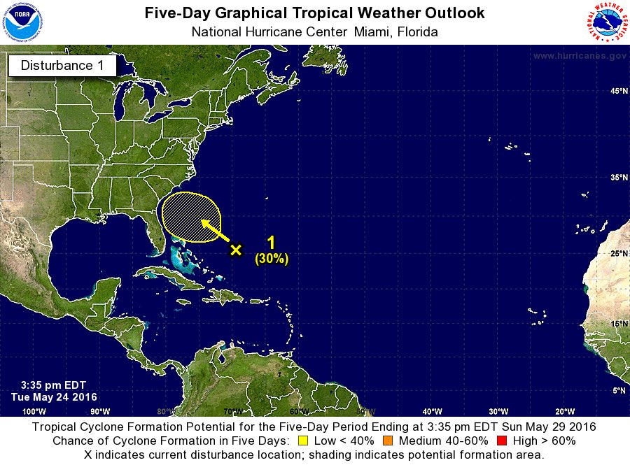
SPECIAL TROPICAL WEATHER OUTLOOK
NWS NATIONAL HURRICANE CENTER MIAMI FL
335 PM EDT TUE MAY 24 2016
For the North Atlantic...Caribbean Sea and the Gulf of Mexico:
An area of showers and thunderstorms over the western Atlantic Ocean
near and northeast of the Bahamas is associated with the
interaction of an upper-level trough and a weakening cold front.
While development is not expected for the next couple of days,
environmental conditions could become more conducive for some
tropical or subtropical development by Friday. This area of
disturbed weather is expected to move slowly west-northwestward or
northwestward and gradually approach the southeastern United
States over the next few days. The next Special Tropical Weather
Outlook will be issued by 4 PM EDT Wednesday.
* Formation chance through 48 hours...low...near 0 percent
* Formation chance through 5 days...low...30 percent
$$
Forecaster Blake
0 likes
Rob Lightbown
Crown Weather Services
https://crownweather.com
Crown Weather Services
https://crownweather.com

-
OuterBanker
- S2K Supporter
- Posts: 1761
- Joined: Wed Feb 26, 2003 10:53 am
- Location: Nags Head, NC
- Contact:
Re: Area of Disturbed Weather North of Eastern Cuba
Question. Is there a specific point in which an outlook becomes an invest?
0 likes
-
TheStormExpert
Re: Area of Disturbed Weather North of Eastern Cuba
OuterBanker wrote:Question. Is there a specific point in which an outlook becomes an invest?
Once we get an established low pressure I believe.
0 likes
-
cycloneye
- Admin
- Posts: 149505
- Age: 69
- Joined: Thu Oct 10, 2002 10:54 am
- Location: San Juan, Puerto Rico
Re: Area of Disturbed Weather North of Eastern Cuba
OuterBanker wrote:Question. Is there a specific point in which an outlook becomes an invest?
I think at link you will have the answer to the question.
http://www.nrlmry.navy.mil/atcf_web/doc ... bering.pdf
0 likes
Visit the Caribbean-Central America Weather Thread where you can find at first post web cams,radars
and observations from Caribbean basin members Click Here
and observations from Caribbean basin members Click Here
-
OuterBanker
- S2K Supporter
- Posts: 1761
- Joined: Wed Feb 26, 2003 10:53 am
- Location: Nags Head, NC
- Contact:
Re: Area of Disturbed Weather North of Eastern Cuba
cycloneye wrote:OuterBanker wrote:Question. Is there a specific point in which an outlook becomes an invest?
I think at link you will have the answer to the question.
http://www.nrlmry.navy.mil/atcf_web/doc ... bering.pdf
Cyclone. The only answer I get from the navy statement is that the TPC/NHC calls the shots. That they are the one that assigns the invest numbers that the USAF uses. What I don't see is a definitive point which they make the call. Seems to me a judgement call by the TPC/NHC. That's fine with me.
0 likes
-
xcool22
Who is online
Users browsing this forum: wwizard, Yellow Evan and 289 guests