
ATL: BONNIE - Post-Tropical - Discussion
Moderator: S2k Moderators

Re: ATL: INVEST 91L - Discussion
I've been watching the models when I've had a chance. I will be arriving in Jacksonville on Friday night before hitting the road again on Saturday morning. Still hoping I can keep most of the wind/rain to my north or have them impact JAX after I leave 
0 likes
-
TheAustinMan

- Category 5

- Posts: 1060
- Joined: Mon Jul 08, 2013 4:26 pm
- Location: Central TX / United States
Re: ATL: INVEST 91L - Models
SHIPS intensity guidance for Invest 91L. SHIPS has landfall between Charleston and Myrtle Beach, South Carolina.
Code: Select all
TIME (HR)          0     6    12    18    24    36    48    60    72    84    96   108   120
V (KT) NO LAND    25    28    30    33    34    37    39    41    44    43    43    43    45
V (KT) LAND       25    28    30    33    34    37    39    41    35    29    28    27    27
V (KT) LGEM       25    26    26    26    25    24    24    25    25    26    27    27    27
Storm Type      TROP  TROP  TROP  TROP  TROP  TROP  TROP  TROP  TROP  TROP  TROP  TROP  TROP
0 likes
Treat my opinions with a grain of salt. For official information see your local weather service.
“It's tough to make predictions, especially about the future.”
“It's tough to make predictions, especially about the future.”


Re: ATL: INVEST 91L - Discussion
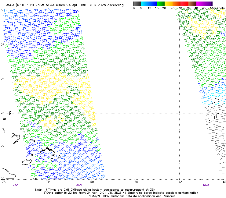
NDG wrote:Too bad it missed half of its circulation.
http://manati.star.nesdis.noaa.gov/asca ... MBas87.png
What happened to launching a more competent instrument more akin to QuikScat?
0 likes
-
northjaxpro

- S2K Supporter

- Posts: 8900
- Joined: Mon Sep 27, 2010 11:21 am
- Location: Jacksonville, FL
Re: ATL: INVEST 91L - Discussion
Evil Jeremy wrote:Oh boy oh boy, here we go! I've recently relocated to Jacksonville from Fort Lauderdale (and previously Tampa), so I'm curious to see how the northern part of the state handles tropical situations. I'm also excited to see how the new GFS handles this scenario. Time to update the tropical bookmarks...
Well welcome to my neck of the woods Evil Jeremy. Hope you will enjoy living here in the Jax area.
0 likes
NEVER, EVER SAY NEVER in the tropics and weather in general, and most importantly, with life itself!!
________________________________________________________________________________________
Fay 2008 Beryl 2012 Debby 2012 Colin 2016 Hermine 2016 Julia 2016 Matthew 2016 Irma 2017 Dorian 2019
________________________________________________________________________________________
Fay 2008 Beryl 2012 Debby 2012 Colin 2016 Hermine 2016 Julia 2016 Matthew 2016 Irma 2017 Dorian 2019
Re: ATL: INVEST 91L - Discussion
Hurricaneman wrote:Hurricane Andrew wrote:Ah, hello all, back for another season.
We've had quite a few years in a row now with storms before June 1. Wasn't there talk recently of extending the ATL Season to May 15?
I only really heard Mark Sudduth say it and looking at numbers it does make sense to an extent
The posts in this forum are NOT official forecast and should not be used as such. They are just the opinion of the poster and may or may not be backed by sound meteorological data. They are NOT endorsed by any professional institution or storm2k.org. For official information, please refer to the NHC and NWS products
I just checked the history since 2010, and even though it definitely seems like we always get a late May storm (which also happens to form off the SE US coast), there's only been an early start to the season in 2012 (with 2 storms off the coast, Beryl affecting Florida) and 2015 (Ana in early May off the coast). Before that there was 2007-09 (with two of the three forming off the coast).
0 likes
-
CrazyC83
- Professional-Met

- Posts: 34315
- Joined: Tue Mar 07, 2006 11:57 pm
- Location: Deep South, for the first time!
Re: ATL: INVEST 91L - Discussion
What's amazing is that in a few weeks I will be going from mostly watching the east coast to mostly watching the Gulf coast for imminent threats...
0 likes
-
WilmingtonSandbar
- S2K Supporter
- Posts: 505
- Joined: Sun Aug 29, 2010 12:11 pm
- Location: Southport, NC
Re: ATL: INVEST 91L - Discussion
It would be nice if people referencing Jacksonville would denote what state they are talking about. Especially when NC is a possible impact for a storm. Is it Jacksonville Florida, or Jacksonville NC that you are talking about? 
0 likes
Diana X2 (look it up), Bertha, Fran, Bonnie, Floyd, Dennis, Charley, Ophelia, Ernesto, Irene, Matthew, And Florence
-
TheStormExpert
Re: ATL: INVEST 91L - Discussion
CrazyC83 wrote:What's amazing is that in a few weeks I will be going from mostly watching the east coast to mostly watching the Gulf coast for imminent threats...
What do you mean?
0 likes
-
CrazyC83
- Professional-Met
- Posts: 34315
- Joined: Tue Mar 07, 2006 11:57 pm
- Location: Deep South, for the first time!
Re: ATL: INVEST 91L - Discussion
TheStormExpert wrote:CrazyC83 wrote:What's amazing is that in a few weeks I will be going from mostly watching the east coast to mostly watching the Gulf coast for imminent threats...
What do you mean?
Relocating to that region in August.
0 likes

Re: ATL: INVEST 91L - Discussion
With all due respect; I think people can safely presume the Jacksonville would mean Florida not North Carolina.
The most populated city in Florida with over 1 million people versus the 14th most populated city in North Carolina with about 70,000 people or so
The most populated city in Florida with over 1 million people versus the 14th most populated city in North Carolina with about 70,000 people or so
Last edited by fci on Thu May 26, 2016 2:16 am, edited 1 time in total.
0 likes
Personal Forecast Disclaimer:
My posts are just my opinion and are most likely not backed by sound meteorological data. They are NOT endorsed by any professional institution or storm2k.org. For official information, please refer to the NHC and NWS products.
Bottom line is that I am just expressing my opinion!!!
My posts are just my opinion and are most likely not backed by sound meteorological data. They are NOT endorsed by any professional institution or storm2k.org. For official information, please refer to the NHC and NWS products.
Bottom line is that I am just expressing my opinion!!!

Re: ATL: INVEST 91L - Models
Euro has been slowly trending stronger, now shows storm intensity at landfall. Even the GFS now shows strengthening right before landfall.
0 likes
The above post is not official and should not be used as such. It is the opinion of the poster and may or may not be backed by sound meteorological data. It is not endorsed by any professional institution or storm2k.org. For official information, please refer to the NHC and NWS products.
-
Evil Jeremy

- S2K Supporter
- Posts: 5463
- Age: 32
- Joined: Mon Apr 10, 2006 2:10 pm
- Location: Los Angeles, CA
Re: ATL: INVEST 91L - Discussion
For what it's worth, I also mentioned Fort Lauderdale and Tampa in the post, two well known Floridian cities, and mentioned my relocation to the northern part of the state.... so context clues.
0 likes
Frances 04 / Jeanne 04 / Katrina 05 / Wilma 05 / Fay 08 / Debby 12 / Andrea 13 / Colin 16 / Hermine 16 / Matthew 16 / Irma 17
-
stormwise
Re: ATL: INVEST 91L - Models

Arpege modeling 55kts @72hrs then some weakening, likely due to the steep drop in sst.
0 likes
-
cycloneye

- Admin

- Posts: 149506
- Age: 69
- Joined: Thu Oct 10, 2002 10:54 am
- Location: San Juan, Puerto Rico
Re: ATL: INVEST 91L - Models
00z UKMET has a weak Tropical Storm.
MET OFFICE TROPICAL CYCLONE GUIDANCE FOR NORTH-EAST PACIFIC
AND ATLANTIC
GLOBAL MODEL DATA TIME 00UTC 26.05.2016
NEW TROPICAL STORM FORECAST TO DEVELOP AFTER 84 HOURS
FORECAST POSITION AT T+ 84 : 32.0N 76.7W
VERIFYING TIME POSITION STRENGTH TENDENCY
-------------- -------- -------- --------
12UTC 29.05.2016 32.0N 76.7W WEAK
00UTC 30.05.2016 32.6N 77.0W WEAK LITTLE CHANGE
12UTC 30.05.2016 32.7N 76.8W WEAK LITTLE CHANGE
00UTC 31.05.2016 33.8N 75.9W WEAK LITTLE CHANGE
12UTC 31.05.2016 34.8N 75.2W WEAK LITTLE CHANGE
00UTC 01.06.2016 35.4N 74.4W WEAK LITTLE CHANGE
THIS INFORMATION IS PROVIDED AS GUIDANCE FOR TROPICAL CYCLONE
RSMCS. IT REQUIRES INTERPRETATION BY TROPICAL CYCLONE SPECIALISTS
AND SHOULD NOT BE CONSIDERED AS A FINAL PRODUCT.
BULLETINS ARE NOW AVAILABLE WHICH PROVIDE EXPLICIT GUIDANCE
ON CENTRAL PRESSURE AND MAXIMUM WIND SPEED.
FOR FURTHER INFORMATION CONTACT TROPICAL_CYCLONES@METOFFICE.GOV.UK
MET OFFICE, EXETER, UK
TOO 260417
0 likes
Visit the Caribbean-Central America Weather Thread where you can find at first post web cams,radars
and observations from Caribbean basin members Click Here
and observations from Caribbean basin members Click Here
-
northjaxpro
- S2K Supporter
- Posts: 8900
- Joined: Mon Sep 27, 2010 11:21 am
- Location: Jacksonville, FL
Re: ATL: INVEST 91L - Discussion
It looks like a mostly dry and hot Memorial weekend is on tap for NE Florida at least through Sunday. The potential tropical cyclone appears to be heading for the South Carolina coast, given the blend of a consensus of the EURO, GFS and CMC models. If the cyclone goes as forecast for now, the Northeast Florida region will stay on the subsident side of the storm, which would bring rather hot conditions here over the holiday weekend.
Now, any shift of the potential track to the south could potentially change our weather here in NE Florida. Thus the reason to watch carefully the next few days.
EURO has trended a little stronger with the potential system, now showing a moderate in strength TS just off the SC coast within 96 hours. I am thinking that will probably come to fruition, but I am not anticipating a hurricane, although it is in the realm of possibly developing into one with the Gulf Stream factor. So, this potentially could cause some issues the next several days for my neighbors just to the north of my locale. Interesting next few days of watching potential Bonnie off the SE U.S. coast.
0 likes
NEVER, EVER SAY NEVER in the tropics and weather in general, and most importantly, with life itself!!
________________________________________________________________________________________
Fay 2008 Beryl 2012 Debby 2012 Colin 2016 Hermine 2016 Julia 2016 Matthew 2016 Irma 2017 Dorian 2019
________________________________________________________________________________________
Fay 2008 Beryl 2012 Debby 2012 Colin 2016 Hermine 2016 Julia 2016 Matthew 2016 Irma 2017 Dorian 2019
-
TheStormExpert
Re: ATL: INVEST 91L - Discussion
SPECIAL TROPICAL WEATHER OUTLOOK
NWS NATIONAL HURRICANE CENTER MIAMI FL
825 AM EDT THU MAY 26 2016
For the North Atlantic...Caribbean Sea and the Gulf of Mexico:
A low pressure area centered between Bermuda and the Bahamas is gradually becoming better defined while shower activity is increasing. Environmental conditions are expected to become more conducive for tropical or subtropical cyclone formation on Friday while the system moves west-northwestward or northwestward toward
the southeastern United States coast. With the Memorial Day weekend approaching, all interests along the southeast coast from Georgia through North Carolina should monitor the progress of this low. An
Air Force reconnaissance plane will be scheduled to investigate this low on Friday. The next Special Tropical Weather Outlook on this disturbance will be issued by 3 PM EDT today. For additional information on this system, see High Seas Forecasts issued by the National Weather Service.
* Formation chance through 48 hours...medium...50 percent
* Formation chance through 5 days...high...70 percent
0 likes
-
TheStormExpert
Re: ATL: INVEST 91L - Discussion
northjaxpro wrote:It looks like a mostly dry and hot Memorial weekend is on tap for NE Florida at least through Sunday. The potential tropical cyclone appears to be heading for the South Carolina coast, given the blend of a consensus of the EURO, GFS and CMC models. If the cyclone goes as forecast for now, the Northeast Florida region will stay on the subsident side of the storm, which would bring rather hot conditions here over the holiday weekend.
Now, any shift of the potential track to the south could potentially change our weather here in NE Florida. Thus the reason to watch carefully the next few days.
EURO has trended a little stronger with the potential system, now showing a moderate in strength TS just off the SC coast within 96 hours. I am thinking that will probably come to fruition, but I am not anticipating a hurricane, although it is in the realm of possibly developing into one with the Gulf Stream factor. So, this potentially could cause some issues the next several days for my neighbors just to the north of my locale. Interesting next few days of watching potential Bonnie off the SE U.S. coast.
Whatever becomes of 91L I believe will be very small and compact in size. This I believe is why the models are struggling some with development.
0 likes
-
northjaxpro
- S2K Supporter
- Posts: 8900
- Joined: Mon Sep 27, 2010 11:21 am
- Location: Jacksonville, FL
Re: ATL: INVEST 91L - Discussion
0 likes
NEVER, EVER SAY NEVER in the tropics and weather in general, and most importantly, with life itself!!
________________________________________________________________________________________
Fay 2008 Beryl 2012 Debby 2012 Colin 2016 Hermine 2016 Julia 2016 Matthew 2016 Irma 2017 Dorian 2019
________________________________________________________________________________________
Fay 2008 Beryl 2012 Debby 2012 Colin 2016 Hermine 2016 Julia 2016 Matthew 2016 Irma 2017 Dorian 2019
-
tolakram
- Admin
- Posts: 20186
- Age: 62
- Joined: Sun Aug 27, 2006 8:23 pm
- Location: Florence, KY (name is Mark)
Re: ATL: INVEST 91L - Discussion
0 likes
M a r k
- - - - -
Join us in chat: Storm2K Chatroom Invite. Android and IOS apps also available.
The posts in this forum are NOT official forecasts and should not be used as such. Posts are NOT endorsed by any professional institution or STORM2K.org. For official information and forecasts, please refer to NHC and NWS products.
Who is online
Users browsing this forum: No registered users and 27 guests