2016 Global Model Runs Discussion (Out to Day 16)
Moderator: S2k Moderators
Forum rules

The posts in this forum are NOT official forecasts and should not be used as such. They are just the opinion of the poster and may or may not be backed by sound meteorological data. They are NOT endorsed by any professional institution or STORM2K. For official information, please refer to products from the National Hurricane Center and National Weather Service.
Re: 2016 Global Model Runs Discussion
well unlike Bonnie's location we've got plenty of warm water down there.. I always cheer on these early season storms as we're typically dry this time of year.
0 likes
-
Kingarabian

- S2K Supporter

- Posts: 16355
- Joined: Sat Aug 08, 2009 3:06 am
- Location: Honolulu, Hawaii
Re: 2016 Global Model Runs Discussion
0z GFS showing a weak low near Florida/Caribbean 240 hours out.
0 likes
RIP Kobe Bryant
Re: 2016 Global Model Runs Discussion
MU and CMC are good for entertainment
MU has 2 weak TSs coming out of the monsoon trough. Meanwhile, the CMC has a HURRICANE hitting New England, IN EARLY JUNE
MU has 2 weak TSs coming out of the monsoon trough. Meanwhile, the CMC has a HURRICANE hitting New England, IN EARLY JUNE
0 likes
-
Kingarabian
- S2K Supporter
- Posts: 16355
- Joined: Sat Aug 08, 2009 3:06 am
- Location: Honolulu, Hawaii
Re: 2016 Global Model Runs Discussion
Alyono wrote:MU and CMC are good for entertainment
MU has 2 weak TSs coming out of the monsoon trough. Meanwhile, the CMC has a HURRICANE hitting New England, IN EARLY JUNE
Euro has a weak TS 240 hours out over southern Florida.
0 likes
RIP Kobe Bryant

Re: 2016 Global Model Runs Discussion
GFS did fairly well with Bonnie, time wise of development, track and time of approaching the coastline, the Euro took a little while to get the timing correct and was a little too aggressive. IMO.
0 likes
-
TheStormExpert
Re: 2016 Global Model Runs Discussion
Well now that Bonnie has come and almost gone it's time to start looking ahain of what could be next?
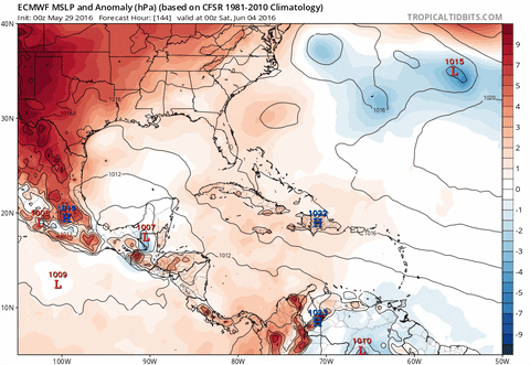
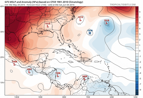
Both the reliable global models Euro, and GFS show something potentially trying to develop in the NW Caribbean or SE Gulf of Mexico come 8-10 days from now. We'll need to watch this as this could be an even more favorbale set-up than what occured with Bonnie IF Wind Shear can relax enough in these regions.
00z Euro 5/29/16
00z GFS 5/29/16
06z GFS 5/29/16
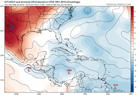
The GFS shows Wind Shear relaxing in the Western Caribbean in 240hrs. *This is long-range and WILL LIKELY CHANGE but it's worth noting as we head into the first month of hurricane season, and this is a climatology favorbale region for TC genesis in June.


Both the reliable global models Euro, and GFS show something potentially trying to develop in the NW Caribbean or SE Gulf of Mexico come 8-10 days from now. We'll need to watch this as this could be an even more favorbale set-up than what occured with Bonnie IF Wind Shear can relax enough in these regions.
00z Euro 5/29/16
00z GFS 5/29/16
06z GFS 5/29/16
The GFS shows Wind Shear relaxing in the Western Caribbean in 240hrs. *This is long-range and WILL LIKELY CHANGE but it's worth noting as we head into the first month of hurricane season, and this is a climatology favorbale region for TC genesis in June.
0 likes
-
gatorcane

- S2K Supporter
- Posts: 23708
- Age: 48
- Joined: Sun Mar 13, 2005 3:54 pm
- Location: Boca Raton, FL
Re: 2016 Global Model Runs Discussion
12Z GFS continues to show a low emerging from the NW Caribbean where it moves north than northeast over South Florida in the long-range. Looks like 1007mb while the ECMWF is 1006mb and slightly further left.
CMC has a hurricane into SW Florida at 156 hours. Likely way overdone.
General idea of a low developing from a monsoon trough across Western Caribbean next weekend with possible weak development and ejecting north or northeast certainly looking increasingly likely
CMC has a hurricane into SW Florida at 156 hours. Likely way overdone.
General idea of a low developing from a monsoon trough across Western Caribbean next weekend with possible weak development and ejecting north or northeast certainly looking increasingly likely
0 likes
-
WeatherEmperor
- S2K Supporter
- Posts: 4806
- Age: 42
- Joined: Thu Sep 04, 2003 2:54 pm
- Location: South Florida
Re: 2016 Global Model Runs Discussion
12z Gfs has a weak TS approaching south florida at 240hrs which is very similar to the 00z Euro from last night. Some model consensus that at the very least some heavy tropical moisture coming Florida's way. Lets see what the 12z Euro shows later today
0 likes
-
TheStormExpert
Re: 2016 Global Model Runs Discussion
WeatherEmperor wrote:12z Gfs has a weak TS approaching south florida at 240hrs which is very similar to the 00z Euro from last night. Some model consensus that at the very least some heavy tropical moisture coming Florida's way. Lets see what the 12z Euro shows later today
That's not a weak Tropical Storm.
0 likes
-
WeatherEmperor
- S2K Supporter
- Posts: 4806
- Age: 42
- Joined: Thu Sep 04, 2003 2:54 pm
- Location: South Florida
Re: 2016 Global Model Runs Discussion
What would you call it then?
TheStormExpert wrote:WeatherEmperor wrote:12z Gfs has a weak TS approaching south florida at 240hrs which is very similar to the 00z Euro from last night. Some model consensus that at the very least some heavy tropical moisture coming Florida's way. Lets see what the 12z Euro shows later today
That's not a weak Tropical Storm.
0 likes
-
TheStormExpert
Re: 2016 Global Model Runs Discussion
WeatherEmperor wrote:What would you call it then?TheStormExpert wrote:WeatherEmperor wrote:12z Gfs has a weak TS approaching south florida at 240hrs which is very similar to the 00z Euro from last night. Some model consensus that at the very least some heavy tropical moisture coming Florida's way. Lets see what the 12z Euro shows later today
That's not a weak Tropical Storm.
More than likely a strung out low, especially when looking at vorticity.
0 likes
Re: 2016 Global Model Runs Discussion
seems like every few years we get an early season appetizer from that region. while they're usually not much from a strong storm standpoint, they can deliver the goods. Debby in 2012 unleashed 15" of rain on my roof and inundated large areas...in addition, it caused a prolonged closure of the sunshine skyway bridge due to winds. I'll be watching with interest in the coming days.
0 likes
-
WeatherEmperor
- S2K Supporter
- Posts: 4806
- Age: 42
- Joined: Thu Sep 04, 2003 2:54 pm
- Location: South Florida
Re: 2016 Global Model Runs Discussion
We have seen named tropical storms that look worse then weak strung out lows so it is possible. The Euro shows a closed off tropical storm on last nights run. Besides look how bad Bonnie looked but still made it to TS status.
Lets wait and see. This is still many days out. The Euro starts in about 30 minutes so lets see what it shows
Lets wait and see. This is still many days out. The Euro starts in about 30 minutes so lets see what it shows
0 likes
-
TheStormExpert
Re: 2016 Global Model Runs Discussion
psyclone wrote:seems like every few years we get an early season appetizer from that region. while they're usually not much from a strong storm standpoint, they can deliver the goods. Debby in 2012 unleashed 15" of rain on my roof and inundated large areas...in addition, it caused a prolonged closure of the sunshine skyway bridge due to winds. I'll be watching with interest in the coming days.
Yeah the pattern is about to switch to more East Coast Troughiness due to the NAO/AO going negative again.
So something even weak and strung out at the very least could come towards Florida from the NW Caribbean.
0 likes
-
WeatherEmperor
- S2K Supporter
- Posts: 4806
- Age: 42
- Joined: Thu Sep 04, 2003 2:54 pm
- Location: South Florida
Re: 2016 Global Model Runs Discussion
This is an important point you make. Isnt it truethat for a few years now we see positive Nao during majority of the Spring season and as soon as Summer arrives it switches to negative with more east coast trofs? Its amazing how this happens the last several years
TheStormExpert wrote:psyclone wrote:seems like every few years we get an early season appetizer from that region. while they're usually not much from a strong storm standpoint, they can deliver the goods. Debby in 2012 unleashed 15" of rain on my roof and inundated large areas...in addition, it caused a prolonged closure of the sunshine skyway bridge due to winds. I'll be watching with interest in the coming days.
Yeah the pattern is about to switch to more East Coast Troughiness due to the NAO/AO going negative again.
So something even weak and strung out at the very least could come towards Florida from the NW Caribbean.
0 likes
-
TheStormExpert
Re: 2016 Global Model Runs Discussion
WeatherEmperor wrote:This is an important point you make. Isnt it truethat for a few years now we see positive Nao during majority of the Spring season and as soon as Summer arrives it switches to negative with more east coast trofs? Its amazing how this happens the last several yearsTheStormExpert wrote:psyclone wrote:seems like every few years we get an early season appetizer from that region. while they're usually not much from a strong storm standpoint, they can deliver the goods. Debby in 2012 unleashed 15" of rain on my roof and inundated large areas...in addition, it caused a prolonged closure of the sunshine skyway bridge due to winds. I'll be watching with interest in the coming days.
Yeah the pattern is about to switch to more East Coast Troughiness due to the NAO/AO going negative again.
So something even weak and strung out at the very least could come towards Florida from the NW Caribbean.
Most of last summer there was more East Coast Ridging with a more positive NAO I believe.
It is far too soon to know if it will ever switch back to a positive NAO with more East Coast Ridging in time for the peak months of the season.
0 likes
Re: 2016 Global Model Runs Discussion
http://www.cpc.ncep.noaa.gov/products/p ... scii.table
0 likes
-
gatorcane
- S2K Supporter
- Posts: 23708
- Age: 48
- Joined: Sun Mar 13, 2005 3:54 pm
- Location: Boca Raton, FL
Re: 2016 Global Model Runs Discussion
12Z ECMWF is basically an extension of the 00Z ECMWF with a 1006MB system developing in the SE Gulf from a low that moves out of the Western Caribbean which recurves NE over the Florida peninsula, timeframe is coming in and the GFS and ECMWF in pretty good agreement on this scenario though still in the long-range:

0 likes
-
gatorcane
- S2K Supporter
- Posts: 23708
- Age: 48
- Joined: Sun Mar 13, 2005 3:54 pm
- Location: Boca Raton, FL
Re: 2016 Global Model Runs Discussion
I will also add the JMA (Japanese global model) 12Z run from today is now showing a low similar to what the GFS, ECMWF and CMC are showing which lifts north out of the Western Caribbean on a recurve trajectory in a similar timeframe. Consensus is quite strong that this time next week we'll have a thread on the Western Caribbean.
0 likes
-
Yellow Evan

- Professional-Met

- Posts: 16232
- Age: 27
- Joined: Fri Jul 15, 2011 12:48 pm
- Location: Henderson, Nevada/Honolulu, HI
- Contact:
Re: 2016 Global Model Runs Discussion
I agree but the GEFS ensemble spread is a bit further west than most global. With that said, most globals show excellent poloraward outflow, which makes me think the GFS/ECMWF may be underestimating this intensity wise but given that this is June, we'll see.
0 likes
Who is online
Users browsing this forum: No registered users and 93 guests