
ATL: COLIN - Post-Tropical - Discussion
Moderator: S2k Moderators
-
cycloneye

- Admin

- Posts: 149414
- Age: 69
- Joined: Thu Oct 10, 2002 10:54 am
- Location: San Juan, Puerto Rico
Re: ATL: INVEST 93L - Discussion-8 AM EDT TWO=Up to 90%-90%
Another Cancun cam.
0 likes
Visit the Caribbean-Central America Weather Thread where you can find at first post web cams,radars
and observations from Caribbean basin members Click Here
and observations from Caribbean basin members Click Here
-
AutoPenalti
- Category 5

- Posts: 4091
- Age: 29
- Joined: Mon Aug 17, 2015 4:16 pm
- Location: Ft. Lauderdale, Florida
Re: ATL: INVEST 93L - Discussion-8 AM EDT TWO=Up to 90%-90%
It looks squashed on the western side.
0 likes
The posts in this forum are NOT official forecasts and should not be used as such. They are just the opinion of the poster and may or may not be backed by sound meteorological data. They are NOT endorsed by any professional institution or STORM2K. For official information, please refer to products from the NHC and NWS.
Model Runs Cheat Sheet:
GFS (5:30 AM/PM, 11:30 AM/PM)
HWRF, GFDL, UKMET, NAVGEM (6:30-8:00 AM/PM, 12:30-2:00 AM/PM)
ECMWF (1:45 AM/PM)
TCVN is a weighted averaged
Re: ATL: INVEST 93L - Discussion
Not sure why the TWO sounds so gloomy - the latest GFS ejects this system out of Florida in or less than 48 hours from now...
There's a lot of shear, typical for early systems...
There's a lot of shear, typical for early systems...
Last edited by Frank2 on Sun Jun 05, 2016 7:30 am, edited 1 time in total.
0 likes
-
Downdraft

- S2K Supporter

- Posts: 906
- Joined: Wed Oct 09, 2002 8:45 pm
- Location: Sanford, Florida
- Contact:
MLB Forecast Discussion
Excerpt from NWS Melbourne forecast discussion.
" MON-TUE...The likelihood remains high for the aforementioned area
of low pressure to transition to near the Yucatan Peninsula and
then emerge into the Gulf of Mexico as a tropical depression/storm
by early Mon. Regardless, models show the system continuing to
aggressively plume northward significant tropical moisture and
high precipitable water to overspread the FL Peninsula for most of
Mon into Tue. Models still differ on the exact timing/track of the
center as it approaches the FL west coast north of Tampa.
However, wind fields will be predominate to the east of the center
and prompt deteriorating conditions from the very start of the
period for Central Florida, initially for the extreme eastern Gulf
and WCFL. Confidence exists for a heavy rain event to unfold which
includes ECFL where 4 to 6 inch event totals (with locally higher
amounts) are possible as the system nears and then crosses the
north half of the peninsula to eject offshore the NEFL coast early
Tue. Highest amounts will be in vicinity and south of where the
center tracks across. Flood watches will likely be in place to
accommodate the periods of heavy rain and embedded squalls. More
so, 0-1 km environmental helicities will increase from the south
to well above 100 Mon morning then to over 300 late Mon per GFS.
This will offer a chance for tornadoes with the threat increasing
as the day progresses boasting a marginal risk. Winds increasing
to 20 to 25 mph with stronger gusts prevalent in squalls during
Mon and Mon night. The southerly flow shifts to the west as the
system ejects Tue but with gusty conditions continuing. State-
scale interests should remain aware for potential tropical
watches/warnings for the FL Peninsula late today or Mon once the
system more fully develops and reveals its tropical character and
intent. Importantly, ECFL should definitely make preparations for
possible flooding rain, isolated tornadoes, and gusty conditions
Mon/Tue. The chance of rain is 90 percent or above Mon and 60-70
percent Tue. Max temps L/M80s Mon and U80s Tue. Min temps in the
M70s."
0 likes
Re: ATL: INVEST 93L - Discussion
Yeah, its going to be a wet Monday, today and Tuesday being the better of the two days. My concern is the local media, who love to give everyone panic attacks for the sake of good ratings ("What you need to know to keep ahead of the storm", etc.) - the public should monitor the NHC site on their phone, rather than bother with non-stop reporters standing in parking lots, JMHO...
0 likes
-
cycloneye
- Admin
- Posts: 149414
- Age: 69
- Joined: Thu Oct 10, 2002 10:54 am
- Location: San Juan, Puerto Rico
Re: ATL: INVEST 93L - Discussion
12z Best Track has the low on the north coast of Yucatan.
AL, 93, 2016060512, , BEST, 0, 217N, 880W, 30, 1005, LO
Location: 21.7°N 88.0°W
Maximum Winds: 30 kt Gusts: N/A
Minimum Central Pressure: 1005 mb
Environmental Pressure: 1008 mb
Radius of Circulation: 300 NM
Radius of Maximum Wind: 150 NM

AL, 93, 2016060512, , BEST, 0, 217N, 880W, 30, 1005, LO
Location: 21.7°N 88.0°W
Maximum Winds: 30 kt Gusts: N/A
Minimum Central Pressure: 1005 mb
Environmental Pressure: 1008 mb
Radius of Circulation: 300 NM
Radius of Maximum Wind: 150 NM
0 likes
Visit the Caribbean-Central America Weather Thread where you can find at first post web cams,radars
and observations from Caribbean basin members Click Here
and observations from Caribbean basin members Click Here
-
tolakram
- Admin
- Posts: 20185
- Age: 62
- Joined: Sun Aug 27, 2006 8:23 pm
- Location: Florence, KY (name is Mark)
Re: ATL: INVEST 93L - Discussion
I was going to say ... perhaps near the tip of the UP?
http://weather.msfc.nasa.gov/cgi-bin/get-goes?satellite=GOES-E%20CONUS&lat=22&lon=-86&info=vis&zoom=1&width=1000&height=800&quality=90&type=Animation&palette=ir1.pal&numframes=10&mapcolor=black
http://weather.msfc.nasa.gov/cgi-bin/get-goes?satellite=GOES-E%20CONUS&lat=22&lon=-86&info=vis&zoom=1&width=1000&height=800&quality=90&type=Animation&palette=ir1.pal&numframes=10&mapcolor=black
0 likes
M a r k
- - - - -
Join us in chat: Storm2K Chatroom Invite. Android and IOS apps also available.
The posts in this forum are NOT official forecasts and should not be used as such. Posts are NOT endorsed by any professional institution or STORM2K.org. For official information and forecasts, please refer to NHC and NWS products.
-
Dean4Storms
- S2K Supporter
- Posts: 6358
- Age: 63
- Joined: Sun Aug 31, 2003 1:01 pm
- Location: Miramar Bch. FL
Re: ATL: INVEST 93L - Discussion
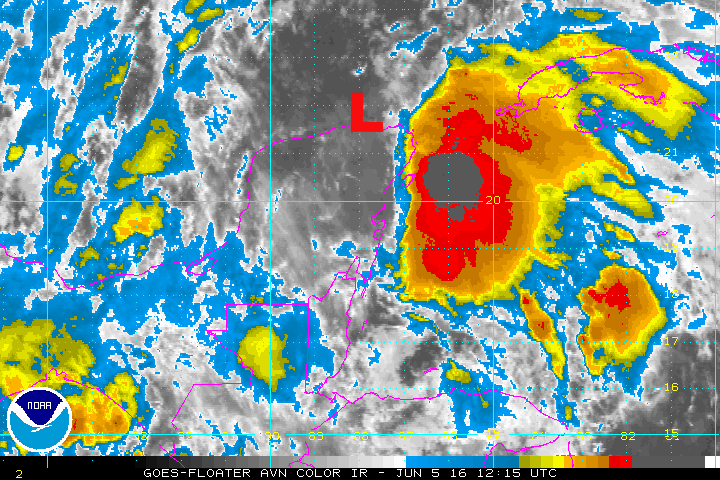
You can clearly see the large over gyre rotating just along the north coast of the Yucatan Peninsula, about where the ECM had had it beginning to develop as it moves northward.
0 likes

Re: ATL: INVEST 93L - Discussion
cycloneye wrote:12z Best Track has the low on the north coast of Yucatan.
AL, 93, 2016060512, , BEST, 0, 217N, 880W, 30, 1005, LO
Location: 21.7°N 88.0°W
Maximum Winds: 30 kt Gusts: N/A
Minimum Central Pressure: 1005 mb
Environmental Pressure: 1008 mb
Radius of Circulation: 300 NM
Radius of Maximum Wind: 150 NM
This is where they place the broad low pressure center, I agree, but most likely we will see an LLC form later this afternoon closer to the deep convection.
0 likes
-
ObsessedMiami
- Category 1

- Posts: 432
- Joined: Tue Aug 31, 2004 8:08 pm
- Location: West Kendall, Fl
Re: ATL: INVEST 93L - Discussion
jlauderdal wrote:I posted on this yesterday and it continues to be the bigger threat down the road for southeast florida especially if the trop system can generate heavy rain mon-tues and moisten up the ground as it has been drive on the eastern side for over a week. North and west of the lake should be ok,,,depends where that boundry sets up. We have seen 8+ in these scenarios before.
AREA FORECAST DISCUSSION
NATIONAL WEATHER SERVICE MIAMI FL
448 AM EDT SUN JUN 5 2016
DISCUSSION
IT IS IMPORTANT TO REMEMBER THAT THE HEAVY RAIN THREAT FOR SOUTH
FLORIDA WILL CONTINUE THROUGH THE WEEK. WE MAY SEE SOME OF OUR
HEAVIEST RAINFALL LATER IN THE WEEK.
Question: why are the rain chances so high for Miami late in the week?
0 likes
-
Dean4Storms
- S2K Supporter
- Posts: 6358
- Age: 63
- Joined: Sun Aug 31, 2003 1:01 pm
- Location: Miramar Bch. FL
Re: ATL: INVEST 93L - Discussion
This really gives you an idea of where the wave axis is now located, lines up perfectly with the cloud tops......
https://earth.nullschool.net/#current/wind/surface/level/orthographic=-86.42,21.81,3000
https://earth.nullschool.net/#current/wind/surface/level/orthographic=-86.42,21.81,3000
0 likes
-
jlauderdal
- S2K Supporter
- Posts: 7240
- Joined: Wed May 19, 2004 5:46 am
- Location: NE Fort Lauderdale
- Contact:
Re: ATL: INVEST 93L - Discussion
ObsessedMiami wrote:jlauderdal wrote:I posted on this yesterday and it continues to be the bigger threat down the road for southeast florida especially if the trop system can generate heavy rain mon-tues and moisten up the ground as it has been drive on the eastern side for over a week. North and west of the lake should be ok,,,depends where that boundry sets up. We have seen 8+ in these scenarios before.
AREA FORECAST DISCUSSION
NATIONAL WEATHER SERVICE MIAMI FL
448 AM EDT SUN JUN 5 2016
DISCUSSION
IT IS IMPORTANT TO REMEMBER THAT THE HEAVY RAIN THREAT FOR SOUTH
FLORIDA WILL CONTINUE THROUGH THE WEEK. WE MAY SEE SOME OF OUR
HEAVIEST RAINFALL LATER IN THE WEEK.
Question: why are the rain chances so high for Miami late in the week?
Stalled out front somewhere in our area with carib moisture running up against it...good recipe for heavy rain
0 likes
-
jlauderdal
- S2K Supporter
- Posts: 7240
- Joined: Wed May 19, 2004 5:46 am
- Location: NE Fort Lauderdale
- Contact:
Re: ATL: INVEST 93L - Discussion
Frank2 wrote:Yeah, its going to be a wet Monday, today and Tuesday being the better of the two days. My concern is the local media, who love to give everyone panic attacks for the sake of good ratings ("What you need to know to keep ahead of the storm", etc.) - the public should monitor the NHC site on their phone, rather than bother with non-stop reporters standing in parking lots, JMHO...
The misinformation from local media is a disservice in some cases.
0 likes
Re: ATL: INVEST 93L - Discussion
Why wouldn't they go ahead and name it now?. Its now at 48 hours til landfall. It would seem people could use those extra hours on the Sunday to prepare.
0 likes
-
HurricaneEric
- Tropical Storm

- Posts: 146
- Age: 31
- Joined: Mon Sep 07, 2015 11:06 am
- Location: Miami, FL
Re: ATL: INVEST 93L - Discussion
jlauderdal wrote:Frank2 wrote:Yeah, its going to be a wet Monday, today and Tuesday being the better of the two days. My concern is the local media, who love to give everyone panic attacks for the sake of good ratings ("What you need to know to keep ahead of the storm", etc.) - the public should monitor the NHC site on their phone, rather than bother with non-stop reporters standing in parking lots, JMHO...
The misinformation from local media is a disservice in some cases.
Unfortunately this is part of what leads to people not taking real severe threats when they come around seriously. Local media (*cough*wsvn*cough*) love to overstate the threat these kinds of storms cause.
0 likes
Irene '99, Katrina '05, Wilma '05, Irma '17 (storms I remember my area getting hurricane force winds/gusts).
The posts in this forum are NOT official forecast and shouldn't be used as such. They are just the opinion of the poster and may or may not be backed by sound meteorological data. For official information, please refer to the experts.
The posts in this forum are NOT official forecast and shouldn't be used as such. They are just the opinion of the poster and may or may not be backed by sound meteorological data. For official information, please refer to the experts.
Re: ATL: INVEST 93L - Discussion
caneman wrote:Why wouldn't they go ahead and name it now?. Its now at 48 hours til landfall. It would seem people could use those extra hours on the Sunday to prepare.
What difference does it make, they have already advice that there could be some tropical storm conditions along the west coast of FL by tomorrow afternoon. Is not like this system will become a major hurricane before landing, no chance at all, IMO.
0 likes
Re: ATL: INVEST 93L - Discussion
It might make a difference for the masses that don't pay attention. While it's not expected to amount to much, storm surge, tornados and rainfall could be real problems. Having a Sunday to grab sandbags, batteries etc.. could be helpful. Just my opinion.
0 likes
-
cycloneye
- Admin
- Posts: 149414
- Age: 69
- Joined: Thu Oct 10, 2002 10:54 am
- Location: San Juan, Puerto Rico
Re: ATL: INVEST 93L - Discussion
caneman wrote:Why wouldn't they go ahead and name it now?. Its now at 48 hours til landfall. It would seem people could use those extra hours on the Sunday to prepare.
There is a high chance that when the plane that will go this afternoon, NHC classifies it as TD or TS depending on the recon data.
0 likes
Visit the Caribbean-Central America Weather Thread where you can find at first post web cams,radars
and observations from Caribbean basin members Click Here
and observations from Caribbean basin members Click Here
Re: ATL: INVEST 93L - Discussion
I agree cycloneye and it seems with the data in place already you could just name it now thereby giving folks 6 to 8 more hours on a Sunday for prep. But that's just my opinion.
0 likes
-
Dean4Storms
- S2K Supporter
- Posts: 6358
- Age: 63
- Joined: Sun Aug 31, 2003 1:01 pm
- Location: Miramar Bch. FL
Re: ATL: INVEST 93L - Discussion
I believe the NHC will post Tropical Storm Watches sometime today whether it is yet named or not.
0 likes
Who is online
Users browsing this forum: No registered users and 4 guests