ATL: COLIN - Post-Tropical - Discussion
Moderator: S2k Moderators
Re: ATL: INVEST 93L - Discussion
0 likes
-
stormwise
-
tarheelprogrammer

- S2K Supporter

- Posts: 1793
- Joined: Mon Mar 28, 2016 9:25 pm
- Location: Raleigh, NC area (Garner, NC)
Re: ATL: INVEST 93L - Discussion
TheStormExpert wrote:Wind Shear is decreasing in the very extreme NW Caribbean, but is remaining strong or increasing in the GoM.


Yes, looking at that map it is hair cutting time. Shear is very strong.
0 likes
My posts are not official forecasts. They are just my opinion and may or may not be backed by sound meteorological data. They are NOT endorsed by any professional institution or storm2k.org. For official information, please refer to the NHC and NWS products.
-
northjaxpro

- S2K Supporter
- Posts: 8900
- Joined: Mon Sep 27, 2010 11:21 am
- Location: Jacksonville, FL
Re: ATL: INVEST 93L - Discussion
Evil Jeremy wrote:Looking at the loops this morning, the broad low just north of Yucatan looks pretty dominant, so much for that relocation to the eastern convection mass...
I agree with you Evil Jeremy. The question posed earlier was if there was a possibility of re-formation, and it was leading into early today, albeit a small probability. Asymmetric system for sure, maybe a 45 kt TS at best.
0 likes
NEVER, EVER SAY NEVER in the tropics and weather in general, and most importantly, with life itself!!
________________________________________________________________________________________
Fay 2008 Beryl 2012 Debby 2012 Colin 2016 Hermine 2016 Julia 2016 Matthew 2016 Irma 2017 Dorian 2019
________________________________________________________________________________________
Fay 2008 Beryl 2012 Debby 2012 Colin 2016 Hermine 2016 Julia 2016 Matthew 2016 Irma 2017 Dorian 2019
-
TheStormExpert
Re: ATL: INVEST 93L - Discussion
psyclone wrote::uarrow: Sweet. Let 'er dump. these are the only types of storms I wish to my backyard
Could really use the rain down here where I'm at in S. FL as well, so BRING IT ON!

0 likes
-
Evil Jeremy

- S2K Supporter
- Posts: 5463
- Age: 32
- Joined: Mon Apr 10, 2006 2:10 pm
- Location: Los Angeles, CA
Re: ATL: INVEST 93L - Discussion
stormwise wrote:That was quick for a low that may not even develop.
If the NHC has started advisories, than it has sufficiently developed.
0 likes
Frances 04 / Jeanne 04 / Katrina 05 / Wilma 05 / Fay 08 / Debby 12 / Andrea 13 / Colin 16 / Hermine 16 / Matthew 16 / Irma 17
-
TheAustinMan

- Category 5

- Posts: 1060
- Joined: Mon Jul 08, 2013 4:26 pm
- Location: Central TX / United States
Re: ATL: INVEST 93L - Discussion
The National Hurricane Center has confirmed their impending advisories.
NHC Atlantic Ops @NHC_Atlantic 9s10 seconds ago
NHC will initiate advisories on Tropical Depression Three at 11 am. This will include a TS Warning for part of the Florida west coast.
0 likes
Treat my opinions with a grain of salt. For official information see your local weather service.
“It's tough to make predictions, especially about the future.”
“It's tough to make predictions, especially about the future.”
-
Evil Jeremy
- S2K Supporter
- Posts: 5463
- Age: 32
- Joined: Mon Apr 10, 2006 2:10 pm
- Location: Los Angeles, CA
Re: ATL: INVEST 93L - Discussion
RL3AO wrote:Advisories on TD Three will begin at 11am. TS warnings for parts of West coast of Florida.
I couldn't find a record of this on the internet until just a minute ago when one of the NHC Twitters tweeted it. Not that I doubt you at all, I'm just glad S2k is capable of getting "scoops"
While a relocation to the eastern convection mass is likely not in the cards, the system's vorticity is still centered to the east of the NHC's fix point, dead center between Cancun and Cuba:

0 likes
Frances 04 / Jeanne 04 / Katrina 05 / Wilma 05 / Fay 08 / Debby 12 / Andrea 13 / Colin 16 / Hermine 16 / Matthew 16 / Irma 17
-
gatorcane

- S2K Supporter
- Posts: 23708
- Age: 48
- Joined: Sun Mar 13, 2005 3:54 pm
- Location: Boca Raton, FL
Re: ATL: INVEST 93L - Discussion
First outer rain bands approach Naples area. Just north of Yucatan low looks dominant and convection looks like it is trying to wrap on eastern side. Hopefully shear should keep it from rapidly organizing as what the global models suggest. Also I notice the presence of a Saharan air layer that has moved into South Florida this morning. Not sure if that might also keep 93l in check
Last edited by gatorcane on Sun Jun 05, 2016 9:41 am, edited 1 time in total.
0 likes
-
cycloneye

- Admin

- Posts: 149414
- Age: 69
- Joined: Thu Oct 10, 2002 10:54 am
- Location: San Juan, Puerto Rico
Re: ATL: INVEST 93L - Discussion
This time they didn't wait for recon to iniciate advisories.
0 likes
Visit the Caribbean-Central America Weather Thread where you can find at first post web cams,radars
and observations from Caribbean basin members Click Here
and observations from Caribbean basin members Click Here
-
Yellow Evan

- Professional-Met

- Posts: 16236
- Age: 27
- Joined: Fri Jul 15, 2011 12:48 pm
- Location: Henderson, Nevada/Honolulu, HI
- Contact:
-
wxman57

- Moderator-Pro Met

- Posts: 23174
- Age: 68
- Joined: Sat Jun 21, 2003 8:06 pm
- Location: Houston, TX (southwest)
Re: ATL: INVEST 93L - Discussion
Interesting that they're being more proactive with this storm (than with Bill last June). I don't think that the LLC is well-defined enough for TD classification, but the NHC may not (yet) be able to issue "Potential Tropical Cyclone" advisories (planned for 2017) so they're calling it a TD a bit early so they can initiate advisories. We've been issuing advisories since Thursday.
"Landfall" looks like a bit north of Cedar Key Monday evening. There may not be much wind/squalls associated with the center, as most squalls should be south and east of the track.
"Landfall" looks like a bit north of Cedar Key Monday evening. There may not be much wind/squalls associated with the center, as most squalls should be south and east of the track.
0 likes
-
johngaltfla

- Category 5
- Posts: 2073
- Joined: Sun Jul 10, 2005 9:17 pm
- Location: Sarasota County, FL
- Contact:
Re: ATL: INVEST 93L - Discussion
wxman57 wrote:Interesting that they're being more proactive with this storm (than with Bill last June). I don't think that the LLC is well-defined enough for TD classification, but the NHC may not (yet) be able to issue "Potential Tropical Cyclone" advisories (planned for 2017) so they're calling it a TD a bit early so they can initiate advisories. We've been issuing advisories since Thursday.
"Landfall" looks like a bit north of Cedar Key Monday evening. There may not be much wind/squalls associated with the center, as most squalls should be south and east of the track.
Yeah, that's going to make for a lot of fun driving tomorrow afternoon and evening from Charlotte County north. Ugh.
0 likes


Re: ATL: INVEST 93L - Discussion
wxman57 wrote:Interesting that they're being more proactive with this storm (than with Bill last June). I don't think that the LLC is well-defined enough for TD classification, but the NHC may not (yet) be able to issue "Potential Tropical Cyclone" advisories (planned for 2017) so they're calling it a TD a bit early so they can initiate advisories. We've been issuing advisories since Thursday.
"Landfall" looks like a bit north of Cedar Key Monday evening. There may not be much wind/squalls associated with the center, as most squalls should be south and east of the track.
Same feelings here. They need the public to recognize the threat here. There has been such a storm drought the past years that most of the public does not really care about what is going on.
0 likes
-
tolakram
- Admin
- Posts: 20185
- Age: 62
- Joined: Sun Aug 27, 2006 8:23 pm
- Location: Florence, KY (name is Mark)
Re: ATL: INVEST 93L - Discussion
25 frame loop, speed it up. (NFL voice) You make the call. 
http://weather.msfc.nasa.gov/cgi-bin/get-goes?satellite=GOES-E%20CONUS&lat=23&lon=-86&info=vis&zoom=1&width=1000&height=800&quality=90&type=Animation&palette=ir1.pal&numframes=25&mapcolor=black
http://weather.msfc.nasa.gov/cgi-bin/get-goes?satellite=GOES-E%20CONUS&lat=23&lon=-86&info=vis&zoom=1&width=1000&height=800&quality=90&type=Animation&palette=ir1.pal&numframes=25&mapcolor=black
0 likes
M a r k
- - - - -
Join us in chat: Storm2K Chatroom Invite. Android and IOS apps also available.
The posts in this forum are NOT official forecasts and should not be used as such. Posts are NOT endorsed by any professional institution or STORM2K.org. For official information and forecasts, please refer to NHC and NWS products.
-
cycloneye
- Admin
- Posts: 149414
- Age: 69
- Joined: Thu Oct 10, 2002 10:54 am
- Location: San Juan, Puerto Rico
ATL: COLIN - Post-Tropical - Advisories
TROPICAL DEPRESSION THREE FORECAST/ADVISORY NUMBER 1
NWS NATIONAL HURRICANE CENTER MIAMI FL AL032016
1500 UTC SUN JUN 05 2016
CHANGES IN WATCHES AND WARNINGS WITH THIS ADVISORY...
A TROPICAL STORM WARNING HAS BEEN ISSUED FOR THE GULF COAST OF
FLORIDA FROM INDIAN PASS TO ENGLEWOOD.
SUMMARY OF WATCHES AND WARNINGS IN EFFECT...
A TROPICAL STORM WARNING IS IN EFFECT FOR...
* INDIAN PASS TO ENGLEWOOD
A TROPICAL STORM WARNING MEANS THAT TROPICAL STORM CONDITIONS ARE
EXPECTED SOMEWHERE WITHIN THE WARNING AREA WITHIN 36 HOURS.
INTERESTS ALONG THE COAST OF NORTHEAST FLORIDA THROUGH SOUTHERN
SOUTH CAROLINA SHOULD MONITOR THE PROGRESS OF THIS SYSTEM.
TROPICAL DEPRESSION CENTER LOCATED NEAR 21.9N 88.1W AT 05/1500Z
POSITION ACCURATE WITHIN 40 NM
PRESENT MOVEMENT TOWARD THE NORTH OR 360 DEGREES AT 7 KT
ESTIMATED MINIMUM CENTRAL PRESSURE 1005 MB
MAX SUSTAINED WINDS 30 KT WITH GUSTS TO 40 KT.
WINDS AND SEAS VARY GREATLY IN EACH QUADRANT. RADII IN NAUTICAL
MILES ARE THE LARGEST RADII EXPECTED ANYWHERE IN THAT QUADRANT.
REPEAT...CENTER LOCATED NEAR 21.9N 88.1W AT 05/1500Z
AT 05/1200Z CENTER WAS LOCATED NEAR 21.7N 88.0W
FORECAST VALID 06/0000Z 24.0N 87.5W
MAX WIND 35 KT...GUSTS 45 KT.
34 KT...120NE 180SE 0SW 0NW.
FORECAST VALID 06/1200Z 26.9N 86.3W
MAX WIND 40 KT...GUSTS 50 KT.
34 KT...120NE 160SE 0SW 0NW.
FORECAST VALID 07/0000Z 29.6N 84.2W
MAX WIND 45 KT...GUSTS 55 KT.
34 KT... 90NE 150SE 0SW 0NW.
FORECAST VALID 07/1200Z 32.6N 79.5W
MAX WIND 45 KT...GUSTS 55 KT.
34 KT... 0NE 150SE 0SW 0NW.
FORECAST VALID 08/1200Z 40.0N 63.0W...POST-TROPICAL
MAX WIND 50 KT...GUSTS 60 KT.
50 KT... 0NE 80SE 0SW 0NW.
34 KT...120NE 150SE 0SW 0NW.
EXTENDED OUTLOOK. NOTE...ERRORS FOR TRACK HAVE AVERAGED NEAR 150 NM
ON DAY 4 AND 200 NM ON DAY 5...AND FOR INTENSITY NEAR 15 KT EACH DAY
OUTLOOK VALID 09/1200Z 46.5N 45.5W...POST-TROP/EXTRATROP
MAX WIND 45 KT...GUSTS 55 KT.
OUTLOOK VALID 10/1200Z 51.0N 32.0W...POST-TROP/EXTRATROP
MAX WIND 45 KT...GUSTS 55 KT.
REQUEST FOR 3 HOURLY SHIP REPORTS WITHIN 300 MILES OF 21.9N 88.1W
NEXT ADVISORY AT 05/2100Z
$$
FORECASTER BROWN
0 likes
Visit the Caribbean-Central America Weather Thread where you can find at first post web cams,radars
and observations from Caribbean basin members Click Here
and observations from Caribbean basin members Click Here
Re: ATL: THREE - Tropical Depression - Discussion
Hi gatorcane, I also noticed the SAL this morning when out walking. As we all know, normally that puts a cap on convection. Usually I'd consider that a bad thing, but in this case it might be very good timing...
0 likes
-
cycloneye
- Admin
- Posts: 149414
- Age: 69
- Joined: Thu Oct 10, 2002 10:54 am
- Location: San Juan, Puerto Rico
Re: ATL: THREE - Tropical Depression - Discussion
BULLETIN
TROPICAL DEPRESSION THREE ADVISORY NUMBER 1
NWS NATIONAL HURRICANE CENTER MIAMI FL AL032016
1000 AM CDT SUN JUN 05 2016
...TROPICAL DEPRESSION FORMS OVER THE SOUTHERN GULF OF MEXICO...
SUMMARY OF 1000 AM CDT...1500 UTC...INFORMATION
-----------------------------------------------
LOCATION...21.9N 88.1W
ABOUT 125 MI...200 KM NW OF COZUMEL MEXICO
ABOUT 550 MI...880 KM SW OF TAMPA FLORIDA
MAXIMUM SUSTAINED WINDS...35 MPH...55 KM/H
PRESENT MOVEMENT...N OR 360 DEGREES AT 8 MPH...13 KM/H
MINIMUM CENTRAL PRESSURE...1005 MB...29.68 INCHES
WATCHES AND WARNINGS
--------------------
CHANGES WITH THIS ADVISORY:
A Tropical Storm Warning has been issued for the Gulf coast of
Florida from Indian Pass to Englewood.
0 likes
Visit the Caribbean-Central America Weather Thread where you can find at first post web cams,radars
and observations from Caribbean basin members Click Here
and observations from Caribbean basin members Click Here
-
tarheelprogrammer
- S2K Supporter
- Posts: 1793
- Joined: Mon Mar 28, 2016 9:25 pm
- Location: Raleigh, NC area (Garner, NC)
Re: ATL: INVEST 93L - Discussion
tolakram wrote:25 frame loop, speed it up. (NFL voice) You make the call.
http://weather.msfc.nasa.gov/cgi-bin/get-goes?satellite=GOES-E%20CONUS&lat=23&lon=-86&info=vis&zoom=1&width=1000&height=800&quality=90&type=Animation&palette=ir1.pal&numframes=25&mapcolor=black
What do you see.
0 likes
My posts are not official forecasts. They are just my opinion and may or may not be backed by sound meteorological data. They are NOT endorsed by any professional institution or storm2k.org. For official information, please refer to the NHC and NWS products.

Re: ATL: THREE - Tropical Depression - Discussion
I think if anything the ULL/trough over TX/MX is starting to help the system ventilate it, yes, there is shear but not that destructive.IMO.
There's some expansion now of the high cloud tops westward.
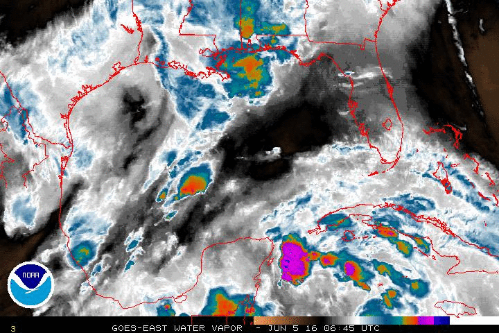
There's some expansion now of the high cloud tops westward.
0 likes
Who is online
Users browsing this forum: No registered users and 10 guests