ATL: COLIN - Post-Tropical - Discussion
Moderator: S2k Moderators
-
northjaxpro

- S2K Supporter

- Posts: 8900
- Joined: Mon Sep 27, 2010 11:21 am
- Location: Jacksonville, FL
Re: ATL: COLIN - Tropical Storm - Discussion
Last edited by northjaxpro on Sun Jun 05, 2016 5:00 pm, edited 1 time in total.
0 likes
NEVER, EVER SAY NEVER in the tropics and weather in general, and most importantly, with life itself!!
________________________________________________________________________________________
Fay 2008 Beryl 2012 Debby 2012 Colin 2016 Hermine 2016 Julia 2016 Matthew 2016 Irma 2017 Dorian 2019
________________________________________________________________________________________
Fay 2008 Beryl 2012 Debby 2012 Colin 2016 Hermine 2016 Julia 2016 Matthew 2016 Irma 2017 Dorian 2019

Re: ATL: COLIN - Tropical Storm - Discussion
gatorcane wrote:Seems the upper-level trough over Eastern Texas might be a little bit weaker than previously thought at least by the GFS. Latest GFS run shows this trough not inducing as much shear over Colin as Colin moves NE in the Eastern Gulf as it was showing in the previous run and consequently the GFS brings this to a strong TS as it makes landfall in the big bend area. WV loop shows this trough quite well. Seems to be getting squashed and is flattening out.

I don't think that it was the UL trough over TX that was originally thought to affect the system negatively, it has always been the larger trough coming down the MS river valley into the eastern US, I think that being that it is not digging that far south is what is helping a environment not to be as bad as earlier forecasted for Colin.
0 likes
-
CrazyC83
- Professional-Met

- Posts: 34315
- Joined: Tue Mar 07, 2006 11:57 pm
- Location: Deep South, for the first time!
Re: ATL: COLIN - Models
At what forecast intensity should a Hurricane Watch be considered? What is the typical margin of error in intensity forecasts at 24-36 hours (not accounting for bombing out)?
0 likes
-
northjaxpro
- S2K Supporter
- Posts: 8900
- Joined: Mon Sep 27, 2010 11:21 am
- Location: Jacksonville, FL
Re: ATL: COLIN - Tropical Storm - Discussion
Yeah, the Upper Trough across the Plains into the Northeast U.S. is the one you are referencing NDG. That has moved more east than south as WV imagery indicates. The amplification of the upper trough has yet to happen fully over the Eastern U.S.
0 likes
NEVER, EVER SAY NEVER in the tropics and weather in general, and most importantly, with life itself!!
________________________________________________________________________________________
Fay 2008 Beryl 2012 Debby 2012 Colin 2016 Hermine 2016 Julia 2016 Matthew 2016 Irma 2017 Dorian 2019
________________________________________________________________________________________
Fay 2008 Beryl 2012 Debby 2012 Colin 2016 Hermine 2016 Julia 2016 Matthew 2016 Irma 2017 Dorian 2019
-
cycloneye

- Admin

- Posts: 149418
- Age: 69
- Joined: Thu Oct 10, 2002 10:54 am
- Location: San Juan, Puerto Rico
Re: ATL: COLIN - Recon
URNT15 KNHC 052153
AF307 0103A CYCLONE HDOB 39 20160605
214400 2356N 08628W 9665 00348 0057 +228 +207 141016 016 020 000 00
214430 2355N 08629W 9663 00350 0057 +229 +204 143015 016 020 000 00
214500 2354N 08630W 9665 00348 0057 +228 +206 142015 015 018 001 00
214530 2353N 08632W 9663 00350 0057 +228 +206 145015 016 019 000 00
214600 2352N 08633W 9664 00348 0056 +229 +211 144017 018 019 001 00
214630 2352N 08634W 9664 00347 0055 +228 +215 147018 018 021 001 00
214700 2351N 08636W 9664 00345 0053 +227 +216 146018 019 023 001 00
214730 2350N 08637W 9664 00345 0053 +225 +216 148017 019 022 004 00
214800 2349N 08638W 9666 00343 0052 +226 +215 152016 017 027 002 00
214830 2348N 08640W 9664 00344 0052 +226 +216 148017 017 024 004 00
214900 2347N 08641W 9662 00345 0051 +228 +216 143017 017 021 004 00
214930 2346N 08643W 9666 00343 0051 +227 +219 138017 018 025 001 00
215000 2345N 08644W 9664 00344 0052 +228 +214 141017 018 020 000 00
215030 2344N 08645W 9664 00343 0051 +226 +216 142016 017 017 000 00
215100 2344N 08647W 9664 00343 0052 +225 +217 139016 017 016 000 00
215130 2343N 08648W 9663 00345 0053 +225 +214 133016 017 015 000 00
215200 2342N 08650W 9664 00345 0054 +228 +206 134016 017 015 000 00
215230 2341N 08651W 9664 00345 0053 +228 +208 134016 017 014 000 00
215300 2340N 08652W 9664 00345 0053 +225 +213 132017 017 016 000 00
215330 2339N 08653W 9664 00344 0053 +225 +216 131016 017 016 000 00
0 likes
Visit the Caribbean-Central America Weather Thread where you can find at first post web cams,radars
and observations from Caribbean basin members Click Here
and observations from Caribbean basin members Click Here

Re: ATL: COLIN - Models
Oh boy! We are ready. Fuel, propane and beer. All can be used later if it sputters. Not sure what the GFS is seeing but if Euro concurs, there will be a lot of people unprepared.
0 likes
The following post is NOT an official forecast and should not be used as such. It is just the opinion of the poster and may or may not be backed by sound meteorological data. It is NOT endorsed by any professional institution including storm2k.org For Official Information please refer to the NHC and NWS products.
-
tropicwatch

- Category 5

- Posts: 3426
- Age: 62
- Joined: Sat Jun 02, 2007 10:01 am
- Location: The Villages, Florida
- Contact:
Re: ATL: COLIN - Tropical Storm - Discussion
I would think that if the front doesn't make it through, this would also slow the progression of Colin down along with giving it a better environment to thrive in. 
Personal Forecast Disclaimer:
The posts in this forum are NOT official forecast and should not be used as such. They are just the opinion of the poster and may or may not be backed by sound meteorological data. They are NOT endorsed by any professional institution or storm2k.org. For official information, please refer to the NHC and NWS products.
0 likes
Tropicwatch
Agnes 72', Eloise 75, Elena 85', Kate 85', Charley 86', Florence 88', Beryl 94', Dean 95', Erin 95', Opal 95', Earl 98', Georges 98', Ivan 2004', Arlene 2005', Dennis 2005', Ida 2009' Debby 2012' Irma 2017' Michael 2018'
Agnes 72', Eloise 75, Elena 85', Kate 85', Charley 86', Florence 88', Beryl 94', Dean 95', Erin 95', Opal 95', Earl 98', Georges 98', Ivan 2004', Arlene 2005', Dennis 2005', Ida 2009' Debby 2012' Irma 2017' Michael 2018'
Re: ATL: COLIN - Tropical Storm - Discussion
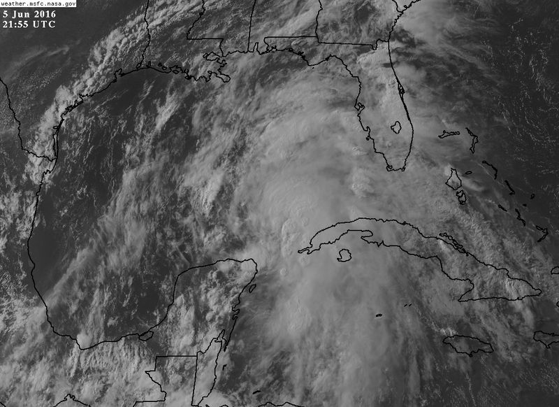
What a difference 12 hours make, it has gotten much better organized during the day, but the surface low center is still displaced from the MLC.
0 likes
-
northjaxpro
- S2K Supporter
- Posts: 8900
- Joined: Mon Sep 27, 2010 11:21 am
- Location: Jacksonville, FL
Re: ATL: COLIN - Models
CrazyC83 wrote:At what forecast intensity should a Hurricane Watch be considered? What is the typical margin of error in intensity forecasts at 24-36 hours (not accounting for bombing out)?
In my view, if the barometric pressure near the COC gets below 1000 mb, that is a decent indicator that could drive NHC to post a possible hurricane watch for portions of the watch region tomorrow, especially likely on the SE ATL coastal side. Granted, that is if the trends continue with strengthening Colin, which has been the case today. NHC just put up Tropical Storm Watch for my area, so I am inclined to think they will extend those watches further up the SE Atlantic Coast if the current trends continue.
0 likes
NEVER, EVER SAY NEVER in the tropics and weather in general, and most importantly, with life itself!!
________________________________________________________________________________________
Fay 2008 Beryl 2012 Debby 2012 Colin 2016 Hermine 2016 Julia 2016 Matthew 2016 Irma 2017 Dorian 2019
________________________________________________________________________________________
Fay 2008 Beryl 2012 Debby 2012 Colin 2016 Hermine 2016 Julia 2016 Matthew 2016 Irma 2017 Dorian 2019
-
SunnyThoughts
- Category 5
- Posts: 2263
- Joined: Wed Jul 09, 2003 12:42 pm
- Location: Pensacola, Florida
Re: ATL: COLIN - Tropical Storm - Discussion
Everybody in the path stay safe. Lots of rain and possible tornadoes in the next day or so.
0 likes
Re: ATL: COLIN - Tropical Storm - Discussion
Recon finds windshift much further east and south than earlier estimated by the NHC on its latest advisory.
Just as I thought
Just as I thought
0 likes
-
johngaltfla

- Category 5
- Posts: 2073
- Joined: Sun Jul 10, 2005 9:17 pm
- Location: Sarasota County, FL
- Contact:
Re: ATL: COLIN - Tropical Storm - Discussion
NDG wrote:What a difference 12 hours make, it has gotten much better organized during the day, but the surface low center is still displaced from the MLC.
I think as the shear relaxes they will co-locate sooner if not overnight and allow for some rapid intensification; not to a hurricane, but definitely stronger with more banding. Storms have a bad tendency to really crank up in our neighborhood.
Personal Forecast Disclaimer:
The posts in this forum are NOT official forecast and should not be used as such. They are just the opinion of the poster and may or may not be backed by sound meteorological data. They are NOT endorsed by any professional institution or storm2k.org. For official information, please refer to the NHC and NWS products.
0 likes
-
cycloneye
- Admin
- Posts: 149418
- Age: 69
- Joined: Thu Oct 10, 2002 10:54 am
- Location: San Juan, Puerto Rico
Re: ATL: COLIN - Recon
URNT15 KNHC 052213
AF307 0103A CYCLONE HDOB 41 20160605
220400 2317N 08721W 9666 00344 0052 +231 +229 128014 014 012 000 01
220430 2316N 08722W 9662 00348 //// +227 //// 120012 014 012 000 01
220500 2315N 08724W 9668 00343 //// +230 //// 130011 013 014 000 01
220530 2315N 08725W 9664 00347 //// +230 //// 124008 010 014 000 01
220600 2314N 08726W 9663 00347 0051 +236 +229 090008 008 012 000 00
220630 2312N 08728W 9665 00345 0052 +236 +229 075006 008 010 000 00
220700 2311N 08728W 9665 00347 0054 +231 +231 089004 005 015 001 01
220730 2310N 08729W 9668 00344 0057 +220 //// 099004 006 029 007 01
220800 2308N 08730W 9660 00350 //// +224 //// 147004 005 017 003 01
220830 2307N 08730W 9673 00338 //// +225 //// 119004 005 018 005 05
220900 2306N 08732W 9662 00349 //// +233 //// 102004 004 013 000 01
220930 2305N 08733W 9664 00345 //// +234 //// 084005 006 014 001 01
221000 2304N 08735W 9668 00343 0052 +236 +234 075003 004 012 001 01
221030 2304N 08736W 9663 00348 0053 +238 +233 057002 004 008 000 00
221100 2303N 08738W 9666 00345 0053 +235 +230 112001 002 008 001 00
221130 2302N 08739W 9663 00348 //// +235 //// 083002 002 007 000 01
221200 2301N 08741W 9663 00349 0054 +235 +233 099003 003 007 000 01
221230 2301N 08742W 9664 00347 0054 +236 +228 092003 004 006 000 00
221300 2300N 08744W 9663 00348 0054 +235 +229 082003 003 008 001 00
221330 2259N 08745W 9667 00345 0054 +235 +227 078002 003 009 000 03
0 likes
Visit the Caribbean-Central America Weather Thread where you can find at first post web cams,radars
and observations from Caribbean basin members Click Here
and observations from Caribbean basin members Click Here
-
cycloneye
- Admin
- Posts: 149418
- Age: 69
- Joined: Thu Oct 10, 2002 10:54 am
- Location: San Juan, Puerto Rico
Re: ATL: COLIN - Recon

0 likes
Visit the Caribbean-Central America Weather Thread where you can find at first post web cams,radars
and observations from Caribbean basin members Click Here
and observations from Caribbean basin members Click Here
-
SeGaBob
Re: ATL: COLIN - Tropical Storm - Discussion
NWS is saying we may get 2-3 inches of rain here and 3-4 on the coast.
0 likes
-
northjaxpro
- S2K Supporter
- Posts: 8900
- Joined: Mon Sep 27, 2010 11:21 am
- Location: Jacksonville, FL
Re: ATL: COLIN - Tropical Storm - Discussion
Also, with the models suddenly indicating a stronger Colin making landfall on the peninsula by tomorrow evening, I would have to believe the Storm Prediction Center out in Oklahoma City will probably increase the threat level for tornadoes from slight to marginal for the next 36 hours. I am really growing concerned about the tornado threat all across the peninsula the next 36 hours or so.
0 likes
NEVER, EVER SAY NEVER in the tropics and weather in general, and most importantly, with life itself!!
________________________________________________________________________________________
Fay 2008 Beryl 2012 Debby 2012 Colin 2016 Hermine 2016 Julia 2016 Matthew 2016 Irma 2017 Dorian 2019
________________________________________________________________________________________
Fay 2008 Beryl 2012 Debby 2012 Colin 2016 Hermine 2016 Julia 2016 Matthew 2016 Irma 2017 Dorian 2019
Re: ATL: COLIN - Tropical Storm - Discussion
Relaxing shear is not good. A strengthening TS at landfall is far different than a disorganized lopsided blob.
0 likes
The following post is NOT an official forecast and should not be used as such. It is just the opinion of the poster and may or may not be backed by sound meteorological data. It is NOT endorsed by any professional institution including storm2k.org For Official Information please refer to the NHC and NWS products.
-
johngaltfla
- Category 5
- Posts: 2073
- Joined: Sun Jul 10, 2005 9:17 pm
- Location: Sarasota County, FL
- Contact:
Re: ATL: COLIN - Tropical Storm - Discussion
NDG wrote:Recon finds windshift much further east and south than earlier estimated by the NHC on its latest advisory.
Just as I thought
That was a good call. Now I wonder as the LLC and MLC migrate together as it appears to be at an angle, if we end up with a big change in trajectory later.
0 likes
-
gatorcane

- S2K Supporter
- Posts: 23708
- Age: 48
- Joined: Sun Mar 13, 2005 3:54 pm
- Location: Boca Raton, FL
Re: ATL: COLIN - Tropical Storm - Discussion
Looks to be organizing if you ask me, storms now blowing up on southern side.
0 likes
-
thundercam96

- Tropical Storm

- Posts: 129
- Joined: Thu Aug 18, 2011 3:01 pm
- Location: Boston, MA
Re: ATL: COLIN - Tropical Storm - Discussion
METs.... How do you view the models intensification of Colin to a moderate/strong TS by tommorow evening?
Last edited by thundercam96 on Sun Jun 05, 2016 5:27 pm, edited 1 time in total.
0 likes
Fay '08 / Mathew 16'
Personal Forecast Disclaimer: I am not a certified meteorologist, therefore, what is posted on this forum under my header should not be treated as an official forecast. Please refer to the NWS/NHC products for forecast information.
Personal Forecast Disclaimer: I am not a certified meteorologist, therefore, what is posted on this forum under my header should not be treated as an official forecast. Please refer to the NWS/NHC products for forecast information.
Who is online
Users browsing this forum: No registered users and 50 guests