Not tropical anymore.
...COLIN BECOMES A POST-TROPICAL CYCLONE...
...GUSTY WINDS AND RAINS OVER THE OUTER BANKS SHOULD BE ENDING
SOON...
SUMMARY OF 1100 AM EDT...1500 UTC...INFORMATION
-----------------------------------------------
LOCATION...34.0N 77.0W
ABOUT 120 MI...190 KM SW OF CAPE HATTERAS NORTH CAROLINA
MAXIMUM SUSTAINED WINDS...60 MPH...95 KM/H
PRESENT MOVEMENT...NE OR 55 DEGREES AT 36 MPH...57 KM/H
MINIMUM CENTRAL PRESSURE...996 MB...29.42 INCHES
ATL: COLIN - Post-Tropical - Discussion
Moderator: S2k Moderators
-
cycloneye

- Admin

- Posts: 149412
- Age: 69
- Joined: Thu Oct 10, 2002 10:54 am
- Location: San Juan, Puerto Rico
Re: ATL: COLIN - Post-Tropical - Discussion
0 likes
Visit the Caribbean-Central America Weather Thread where you can find at first post web cams,radars
and observations from Caribbean basin members Click Here
and observations from Caribbean basin members Click Here
-
jlauderdal
- S2K Supporter

- Posts: 7240
- Joined: Wed May 19, 2004 5:46 am
- Location: NE Fort Lauderdale
- Contact:
Re: ATL: COLIN - Tropical Storm - Discussion
Phoenix78 wrote:My location (Vero Beach South) has received 0" of rainfall the last 36 hours. Go figure! ...Alan
The south florida rain machine is getting going...totals were meager yesterday but we had full sun earlier today and the atmosphere is responding on schedule.
0 likes
-
TheStormExpert
Re: ATL: COLIN - Tropical Storm - Discussion
jlauderdal wrote:Phoenix78 wrote:My location (Vero Beach South) has received 0" of rainfall the last 36 hours. Go figure! ...Alan
The south florida rain machine is getting going...totals were meager yesterday but we had full sun earlier today and the atmosphere is responding on schedule.
Our best chances for possible decent rainfall here in S. FL are today through late week with tomorrow and Thursday being the best days at the moment.
0 likes
-
AutoPenalti
- Category 5

- Posts: 4091
- Age: 29
- Joined: Mon Aug 17, 2015 4:16 pm
- Location: Ft. Lauderdale, Florida
Re: ATL: COLIN - Post-Tropical - Discussion
We have 0" of rain in Pompano Beach, to put it in context, a cloud loaded with rain just skidded the eastern side of Coconut Creek and it's sunny and dry.
0 likes
The posts in this forum are NOT official forecasts and should not be used as such. They are just the opinion of the poster and may or may not be backed by sound meteorological data. They are NOT endorsed by any professional institution or STORM2K. For official information, please refer to products from the NHC and NWS.
Model Runs Cheat Sheet:
GFS (5:30 AM/PM, 11:30 AM/PM)
HWRF, GFDL, UKMET, NAVGEM (6:30-8:00 AM/PM, 12:30-2:00 AM/PM)
ECMWF (1:45 AM/PM)
TCVN is a weighted averaged
-
northjaxpro

- S2K Supporter
- Posts: 8900
- Joined: Mon Sep 27, 2010 11:21 am
- Location: Jacksonville, FL
Re: ATL: COLIN - Post-Tropical - Discussion
Anyone notice a spin or rotation currently down in the Gulf of Hondurus? I have not checked the 850 mb low level vorticity analysis yet, but I am curious what is going on down there.
EDIT: GFS is showing a Low moving north into the SE Gulf within 48 hours. Curious what the EURO may have.
EDIT: GFS is showing a Low moving north into the SE Gulf within 48 hours. Curious what the EURO may have.
Last edited by northjaxpro on Tue Jun 07, 2016 10:46 am, edited 1 time in total.
0 likes
NEVER, EVER SAY NEVER in the tropics and weather in general, and most importantly, with life itself!!
________________________________________________________________________________________
Fay 2008 Beryl 2012 Debby 2012 Colin 2016 Hermine 2016 Julia 2016 Matthew 2016 Irma 2017 Dorian 2019
________________________________________________________________________________________
Fay 2008 Beryl 2012 Debby 2012 Colin 2016 Hermine 2016 Julia 2016 Matthew 2016 Irma 2017 Dorian 2019
Re: ATL: COLIN - Post-Tropical - Discussion
Colin Part II. Yes I did notice that. Some of the models have been toying with the idea of another one near the base of the trough.
0 likes
Re: ATL: COLIN - Post-Tropical - Discussion
Colin Part II. Yes I did notice that. Some of the models have been toying with the idea of another one near the base of the trough.
0 likes
-
thundercam96

- Tropical Storm

- Posts: 129
- Joined: Thu Aug 18, 2011 3:01 pm
- Location: Boston, MA
Re: ATL: COLIN - Post-Tropical - Discussion
Steve H. wrote:Colin Part II. Yes I did notice that. Some of the models have been toying with the idea of another one near the base of the trough.
This has been discussed in the 2016 Global Model Runs thread.... Quite interesting to say the least
0 likes
Fay '08 / Mathew 16'
Personal Forecast Disclaimer: I am not a certified meteorologist, therefore, what is posted on this forum under my header should not be treated as an official forecast. Please refer to the NWS/NHC products for forecast information.
Personal Forecast Disclaimer: I am not a certified meteorologist, therefore, what is posted on this forum under my header should not be treated as an official forecast. Please refer to the NWS/NHC products for forecast information.
-
northjaxpro
- S2K Supporter
- Posts: 8900
- Joined: Mon Sep 27, 2010 11:21 am
- Location: Jacksonville, FL
Re: ATL: COLIN - Post-Tropical - Discussion
0 likes
NEVER, EVER SAY NEVER in the tropics and weather in general, and most importantly, with life itself!!
________________________________________________________________________________________
Fay 2008 Beryl 2012 Debby 2012 Colin 2016 Hermine 2016 Julia 2016 Matthew 2016 Irma 2017 Dorian 2019
________________________________________________________________________________________
Fay 2008 Beryl 2012 Debby 2012 Colin 2016 Hermine 2016 Julia 2016 Matthew 2016 Irma 2017 Dorian 2019
-
cycloneye
- Admin
- Posts: 149412
- Age: 69
- Joined: Thu Oct 10, 2002 10:54 am
- Location: San Juan, Puerto Rico
Re: ATL: COLIN - Post-Tropical - Discussion
For comments about any other development in the future you can visit the 2016 Global Model Runs Discussion thread
0 likes
Visit the Caribbean-Central America Weather Thread where you can find at first post web cams,radars
and observations from Caribbean basin members Click Here
and observations from Caribbean basin members Click Here
-
cycloneye
- Admin
- Posts: 149412
- Age: 69
- Joined: Thu Oct 10, 2002 10:54 am
- Location: San Juan, Puerto Rico
Re: ATL: COLIN - Post-Tropical - Advisories
BULLETIN
POST-TROPICAL CYCLONE COLIN INTERMEDIATE ADVISORY NUMBER 9A
NWS NATIONAL HURRICANE CENTER MIAMI FL AL032016
200 PM EDT TUE JUN 07 2016
...POST-TROPICAL COLIN MOVING AWAY FROM THE COAST OF NORTH
CAROLINA...
SUMMARY OF 200 PM EDT...1800 UTC...INFORMATION
----------------------------------------------
LOCATION...35.3N 74.7W
ABOUT 45 MI...75 KM E OF CAPE HATTERAS NORTH CAROLINA
MAXIMUM SUSTAINED WINDS...60 MPH...95 KM/H
PRESENT MOVEMENT...NE OR 55 DEGREES AT 38 MPH...61 KM/H
MINIMUM CENTRAL PRESSURE...996 MB...29.42 INCHES
WATCHES AND WARNINGS
--------------------
CHANGES WITH THIS ADVISORY:
All tropical storm warnings have been discontinued.
SUMMARY OF WATCHES AND WARNINGS IN EFFECT:
There are no coastal watches or warnings in effect.
DISCUSSION AND 48-HOUR OUTLOOK
------------------------------
At 200 PM EDT (1800 UTC), the center of Post-Tropical Cyclone Colin
was estimated near latitude 35.3 North, longitude 74.7 West. The
post-tropical cyclone is moving toward the northeast near 38 mph
(61 km/h) and this general motion is expected to continue through
Wednesday. The center of Colin will move away from the North
Carolina coast this afternoon and pass well east of the mid-Atlantic
coast later today.
Maximum sustained winds are near 60 mph (95 km/h) with higher gusts,
although the system's strongest winds and heaviest rains are located
over water well southeast of the center. Some slight strengthening
is possible today and tonight, but gradual weakening is expected to
begin on Wednesday.
Tropical-storm-force winds extend outward up to 230 miles (370 km)
primarily to the southeast of the center.
The estimated minimum central pressure is 996 mb (29.42 inches).
HAZARDS AFFECTING LAND
----------------------
RAINFALL: Colin is expected to produce additional rainfall
amounts of 1 to 2 inches across far eastern North Carolina
and 1 to 3 inches, with isolated maximum amounts of 5 inches,
across central Florida through this evening.
STORM SURGE: Water levels remain elevated along the west coast
of the Florida peninsula, but are expected to subside by this
evening.
Localized coastal flooding and dangerous surf are possible along
portions of the Outer Banks of North Carolina this afternoon. For
information specific to your area, please see products issued by
your local National Weather Service forecast office.
NEXT ADVISORY
-------------
Next complete advisory at 500 PM EDT.
$$
Forecaster Brown
0 likes
Visit the Caribbean-Central America Weather Thread where you can find at first post web cams,radars
and observations from Caribbean basin members Click Here
and observations from Caribbean basin members Click Here
-
CrazyC83
- Professional-Met

- Posts: 34315
- Joined: Tue Mar 07, 2006 11:57 pm
- Location: Deep South, for the first time!
Re: ATL: COLIN - Post-Tropical - Discussion
Personally, when it comes to the final BT, I would move the time that Colin became post-tropical up to 0000Z, and also it would NOT be considered a TC landfall.
0 likes
-
wxman57

- Moderator-Pro Met

- Posts: 23173
- Age: 68
- Joined: Sat Jun 21, 2003 8:06 pm
- Location: Houston, TX (southwest)
Re: ATL: COLIN - Post-Tropical - Discussion
There. First Bones appearance of the season.
My coworker and I were just discussing the extreme quiet in the West Pacific so far. Almost the longest period on record with no TCs (20 more days). An inactive W. Pac may well mean an active Atlantic...

My coworker and I were just discussing the extreme quiet in the West Pacific so far. Almost the longest period on record with no TCs (20 more days). An inactive W. Pac may well mean an active Atlantic...
0 likes
Re: ATL: COLIN - Post-Tropical - Discussion
1) Gainesville, FL, got 5.65" of rain on 6/6/16. That is tied for 8th highest for one calendar day with one other year going back to 1890. So, getting 5.65"+ on any one calendar day has been about a 1 in 14 years occurrence. So, whereas it wasn't historic, it was clearly a major event in their history.
They have now had 15 calendar days with 5"+ since 1890. So, that occurs about once every 8 years.
2) It appears that Gainesville ended up officially with 5.95" of precip. directly from Colin if nothing is counted from 6/5.
How does that compare to past TC's there? I have it as their 11th heaviest storm total from a TC since 1890:
Heaviest total rainfall from a TC at Gainesville:
1) Sep. of 1894 H: 12.68" (Gulf)
2) June of 2012 TS Debby: 12.02" (Gulf)
3) Sep. of 1950 H Easy: 11.28" (Gulf)
4) Sep. of 1964 H Dora 10.69" (Atlantic)
5) Sep. of 2004 H Francis 10.56" (Atlantic)
6) Oct. of 1944 H: 9.10" (Gulf)
7) July of 1909 TS: 8.03" (Atlantic)
8) June of 1893 TS: 6.62" (Gulf)
9) Sep. of 1947 TS: 6.33" (Gulf)
10) Aug of 1937 TS: 6.08" (Atlantic)
11) June of 2016 TS Colin 5.95" (Gulf)
So, Colin wasn't even close to the heaviest but it certainly was a major TC related event rainfallwise (about a once in 12 years event) and was the 3rd heaviest from a June TC.
0 likes
Personal Forecast Disclaimer:
The posts in this forum are NOT official forecasts and should not be used as such. They are just the opinion of the poster and may or may not be backed by sound meteorological data. They are NOT endorsed by any professional institution or storm2k.org. For official information, please refer to the NHC and NWS products.
The posts in this forum are NOT official forecasts and should not be used as such. They are just the opinion of the poster and may or may not be backed by sound meteorological data. They are NOT endorsed by any professional institution or storm2k.org. For official information, please refer to the NHC and NWS products.
-
cycloneye
- Admin
- Posts: 149412
- Age: 69
- Joined: Thu Oct 10, 2002 10:54 am
- Location: San Juan, Puerto Rico
Re: ATL: COLIN - Post-Tropical - Advisories
BULLETIN
POST-TROPICAL CYCLONE COLIN ADVISORY NUMBER 10
NWS NATIONAL HURRICANE CENTER MIAMI FL AL032016
500 PM EDT TUE JUN 07 2016
...POST-TROPICAL COLIN MOVING AWAY FROM THE EAST COAST OF THE
UNITED STATES...
...THIS IS THE LAST ADVISORY...
SUMMARY OF 500 PM EDT...2100 UTC...INFORMATION
----------------------------------------------
LOCATION...36.5N 72.2W
ABOUT 205 MI...330 KM ENE OF CAPE HATTERAS NORTH CAROLINA
MAXIMUM SUSTAINED WINDS...60 MPH...95 KM/H
PRESENT MOVEMENT...NE OR 55 DEGREES AT 40 MPH...65 KM/H
MINIMUM CENTRAL PRESSURE...996 MB...29.42 INCHES
WATCHES AND WARNINGS
--------------------
There are no coastal watches or warnings in effect.
DISCUSSION AND 48-HOUR OUTLOOK
------------------------------
At 500 PM EDT (2100 UTC), the center of Post-Tropical Cyclone Colin
was located near latitude 36.5 North, longitude 72.2 West. The
post-tropical cyclone is moving toward the northeast near 40 mph (65
km/h) and this general motion is expected to continue through
Wednesday night.
Maximum sustained winds are near 60 mph (95 km/h) with higher gusts.
Some slight strengthening is possible tonight, but gradual weakening
is expected to begin on Wednesday.
Tropical-storm-force winds extend outward up to 240 miles (390 km)
primarily to the southeast of the center.
The estimated minimum central pressure is 996 mb (29.42 inches).
HAZARDS AFFECTING LAND
----------------------
None.
NEXT ADVISORY
-------------
This is the last public advisory issued by the National Hurricane
Center on this system. Future information on this system can be
found in High Seas Forecasts issued by the National Weather Service,
under AWIPS header NFDHSFAT1, WMO header FZNT01 KWBC, and available
on the Web at http://www.opc.ncep.noaa.gov/shtml/NFDHSFAT1.shtml.
$$
Forecaster Brown
POST-TROPICAL CYCLONE COLIN DISCUSSION NUMBER 10
NWS NATIONAL HURRICANE CENTER MIAMI FL AL032016
500 PM EDT TUE JUN 07 2016
Colin is now being analyzed as a fully extratropical cyclone with
frontal features. The gusty winds and rainfall has cleared the
coast of North Carolina; therefore this will be the final NHC
advisory on this system. The low's intensity remains 50 kt, which
is in agreement with an earlier ASCAT pass that showed a large area
of 40-45 kt winds well to the southeast of the center. The
extratropical cyclone will likely deepen tonight due to baroclinic
energetics, but gradual weakening is forecast to begin on Wednesday
while the low moves over the North Atlantic. The forecast
intensities and wind radii are based on guidance provided by the
Ocean Prediction Center.
The cyclone is racing northeastward at about 35 kt, and this
general motion is expected to continue during the next day or so.
After that time, the low should decelerate as it moves moves around
a couple of larger extratropical lows over the North Atlantic.
This is the last advisory issued by the National Hurricane Center
on Colin. Future information on this system can be found in High
Seas Forecasts issued by the National Weather Service, under AWIPS
header NFDHSFAT1, WMO header FZNT01 KWBC, and available on the Web
at http://www.opc.ncep.noaa.gov/shtml/NFDHSFAT1.shtml.
FORECAST POSITIONS AND MAX WINDS
INIT 07/2100Z 36.5N 72.2W 50 KT 60 MPH...POST-TROP/EXTRATROP
12H 08/0600Z 39.5N 65.5W 55 KT 65 MPH...POST-TROP/EXTRATROP
24H 08/1800Z 43.5N 56.5W 50 KT 60 MPH...POST-TROP/EXTRATROP
36H 09/0600Z 46.5N 49.0W 40 KT 45 MPH...POST-TROP/EXTRATROP
48H 09/1800Z 48.0N 43.0W 40 KT 45 MPH...POST-TROP/EXTRATROP
72H 10/1800Z 53.0N 37.0W 40 KT 45 MPH...POST-TROP/EXTRATROP
96H 11/1800Z...Absorbed
$$
Forecaster Brown
0 likes
Visit the Caribbean-Central America Weather Thread where you can find at first post web cams,radars
and observations from Caribbean basin members Click Here
and observations from Caribbean basin members Click Here
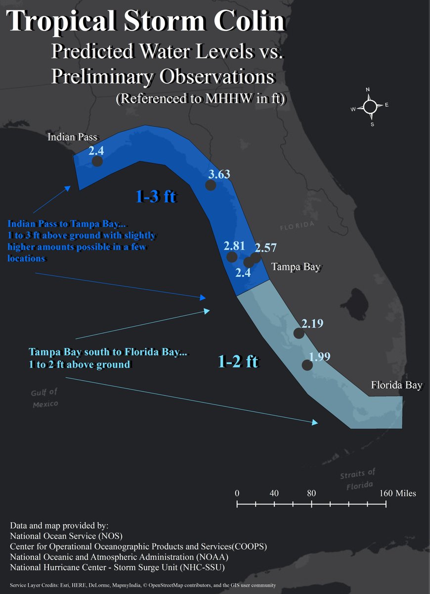
Re: ATL: COLIN - Post-Tropical - Discussion
Storm Surge Forecast vs Observations for Colin
https://twitter.com/NHC_Surge/status/740966532981854208
https://twitter.com/NHC_Surge/status/740966532981854208
0 likes
Who is online
Users browsing this forum: No registered users and 4 guests