Seasonal Indicators (Beyond Day 16): Instability / SST's / MSLP / Steering / Sal

This is the general tropical discussion area. Anyone can take their shot at predicting a storms path.

Moderator: S2k Moderators

Forum rules

The posts in this forum are NOT official forecasts and should not be used as such. They are just the opinion of the poster and may or may not be backed by sound meteorological data. They are NOT endorsed by any professional institution or STORM2K. For official information, please refer to products from the National Hurricane Center and National Weather Service.

Help Support Storm2K
Message
Author
TheStormExpert

Re: 2016 indicators: Instability / SST's / MSLP / Steering / Sal

#561 Postby TheStormExpert » Thu Jun 09, 2016 11:45 am

wxman57 wrote:I think there's a very good chance that the U.S. major hurricane drought will end in 2016.

Interesting statement. :eek:

If I remember correctly you said around this time last year that we would likely go yet another season without a major hurricane landfall in the U.S. in 2015 due to the record Strong El Niño and you were exactly spot on!

Personally I think the drought will either end this season or next. As for Florida's hurricane drought I'm thinking the same this year or next.
0 likes   

WeatherEmperor
S2K Supporter
S2K Supporter
Posts: 4806
Age: 41
Joined: Thu Sep 04, 2003 2:54 pm
Location: South Florida

Re: 2016 indicators: Instability / SST's / MSLP / Steering / Sal

#562 Postby WeatherEmperor » Thu Jun 09, 2016 12:00 pm

I agree with you about Florida. Many pro mets such as wxman57 believe the NW Caribbean could be more active this year and many past Florida hurricanes came from the NW Caribbean in October.

Because there is more NW Caribbean action forecasted this year it really doesnt matter if there is an east coast ridge or trough because Florida can get hit from all directions. More ridging and Florida is at increased threat from Cape Verde hurricanes during Aug/Sept. More troughing and Florida could be at increased threat for October systems coming from the NW Caribbean.

TheStormExpert wrote:
wxman57 wrote:I think there's a very good chance that the U.S. major hurricane drought will end in 2016.

Interesting statement. :eek:

If I remember correctly you said around this time last year that we would likely go yet another season without a major hurricane landfall in the U.S. in 2015 due to the record Strong El Niño and you were exactly spot on!

Personally I think the drought will either end this season or next. As for Florida's hurricane drought I'm thinking the same this year or next.
0 likes   

User avatar
tarheelprogrammer
S2K Supporter
S2K Supporter
Posts: 1793
Joined: Mon Mar 28, 2016 9:25 pm
Location: Raleigh, NC area (Garner, NC)

Re: 2016 indicators: Instability / SST's / MSLP / Steering / Sal

#563 Postby tarheelprogrammer » Thu Jun 09, 2016 3:20 pm

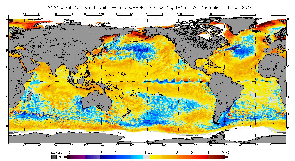
Post from someone on twitter.

Image

He says it looks more like a +AMO SSTA signature.
0 likes   
My posts are not official forecasts. They are just my opinion and may or may not be backed by sound meteorological data. They are NOT endorsed by any professional institution or storm2k.org. For official information, please refer to the NHC and NWS products.

User avatar
Hurricaneman
Category 5
Category 5
Posts: 7351
Age: 45
Joined: Tue Aug 31, 2004 3:24 pm
Location: central florida

Re: 2016 indicators: Instability / SST's / MSLP / Steering / Sal

#564 Postby Hurricaneman » Thu Jun 09, 2016 3:43 pm

Looks like we're even establishing a positive tripole too which all indications are heading for a major hurricane season not unlike 1998. 2005 is another season to use as an analog but the MDR was much warmer than now so its like an honorable mention analog and not a top analog

The posts in this forum are NOT official forecast and should not be used as such. They are just the opinion of the poster and may or may not be backed by sound meteorological data. They are NOT endorsed by any professional institution or storm2k.org. For official information, please refer to the NHC and NWS products
0 likes   

ninel conde

Re: 2016 indicators: Instability / SST's / MSLP / Steering / Sal

#565 Postby ninel conde » Thu Jun 09, 2016 6:24 pm

WeatherEmperor wrote:I agree with you about Florida. Many pro mets such as wxman57 believe the NW Caribbean could be more active this year and many past Florida hurricanes came from the NW Caribbean in October.

Because there is more NW Caribbean action forecasted this year it really doesnt matter if there is an east coast ridge or trough because Florida can get hit from all directions. More ridging and Florida is at increased threat from Cape Verde hurricanes during Aug/Sept. More troughing and Florida could be at increased threat for October systems coming from the NW Caribbean.

TheStormExpert wrote:
wxman57 wrote:I think there's a very good chance that the U.S. major hurricane drought will end in 2016.

Interesting statement. :eek:

If I remember correctly you said around this time last year that we would likely go yet another season without a major hurricane landfall in the U.S. in 2015 due to the record Strong El Niño and you were exactly spot on!

Personally I think the drought will either end this season or next. As for Florida's hurricane drought I'm thinking the same this year or next.


I would say the east coast trof makes a huge difference to florida. we can see that easily as a trof has dominated since 2006 and no canes.
0 likes   

User avatar
bg1
Category 1
Category 1
Posts: 409
Joined: Fri May 13, 2011 11:14 am
Location: near Santee, SC

Re: 2016 indicators: Instability / SST's / MSLP / Steering / Sal

#566 Postby bg1 » Thu Jun 09, 2016 6:38 pm

SFLcane wrote:
wxman57 wrote:Last year, for example, a strong El Nino was predicted, which was expected to result in a very quiet Caribbean Sea due to strong wind shear. Plus, the ECMWF was predicting extremely dry conditions from the southern Gulf to the coast of Africa, primarily due to subsidence. We saw that in the instability graphics - very stable air dominated the Caribbean & Gulf. Not this year (see below).

In addition, cooling in the NE Atlantic (AMO area) is indicative of a stronger Azores-Bermuda high, which means stronger easterly trades between the Caribbean & Africa. Stronger trades there mean more low-level shear and upwelling of cooler water, making the MDR less favorable for development this season (maybe not as inhospitable as 2015, though). Those stronger tradewinds will be slowing down when they reach the western Caribbean, resulting in low-level convergence. We didn't see that last season, for the most part.

I think there's a very good chance that the U.S. major hurricane drought will end in 2016.

Image


Woah ok.. you seem rather confident on this season being active so Iam paying attention. It will come as a rude awaking especially in Florida. Most have no knowledge or what it's like going through a bonified major let alone any hurricane of any category. We shall see thx for your insight.


Thanks for answering my question wxman57! I didn't know instability finally returned to normal in the Caribbean. I'll be paying close attention too this year (not that I normally don't :P).
0 likes   

CaliforniaResident
Tropical Storm
Tropical Storm
Posts: 212
Joined: Fri Feb 21, 2014 1:47 pm

Re: 2016 indicators: Instability / SST's / MSLP / Steering / Sal

#567 Postby CaliforniaResident » Thu Jun 09, 2016 7:33 pm

If we extrapolate what the heart of the season will look like based on what we've seen so far (3rd named storm by June 5th!!), 2016 could even pass 2005 (didn't get its third named storm until a full month later then this year) in the number of named storms (although the ACE could be lower due to fewer major hurricanes).
0 likes   

User avatar
WPBWeather
S2K Supporter
S2K Supporter
Posts: 535
Age: 67
Joined: Thu Jul 18, 2013 12:33 pm

Re: 2016 indicators: Instability / SST's / MSLP / Steering / Sal

#568 Postby WPBWeather » Thu Jun 09, 2016 8:01 pm

ninel conde wrote:
WeatherEmperor wrote:I agree with you about Florida. Many pro mets such as wxman57 believe the NW Caribbean could be more active this year and many past Florida hurricanes came from the NW Caribbean in October.

Because there is more NW Caribbean action forecasted this year it really doesnt matter if there is an east coast ridge or trough because Florida can get hit from all directions. More ridging and Florida is at increased threat from Cape Verde hurricanes during Aug/Sept. More troughing and Florida could be at increased threat for October systems coming from the NW Caribbean.

TheStormExpert wrote:Interesting statement. :eek:

If I remember correctly you said around this time last year that we would likely go yet another season without a major hurricane landfall in the U.S. in 2015 due to the record Strong El Niño and you were exactly spot on!

Personally I think the drought will either end this season or next. As for Florida's hurricane drought I'm thinking the same this year or next.


I would say the east coast trof makes a huge difference to florida. we can see that easily as a trof has dominated since 2006 and no canes.


Hi there. Hope you are correct with that trof of yours!
0 likes   

User avatar
gatorcane
S2K Supporter
S2K Supporter
Posts: 23691
Age: 47
Joined: Sun Mar 13, 2005 3:54 pm
Location: Boca Raton, FL

Re: 2016 indicators: Instability / SST's / MSLP / Steering / Sal

#569 Postby gatorcane » Thu Jun 09, 2016 8:29 pm

Hammy wrote:I've been seeing quite a few fairly strong tropical waves over Africa over the last several weeks for it being so early in the season.


Indeed, latest image shows three areas of robust convection

Image
0 likes   

User avatar
Hurricaneman
Category 5
Category 5
Posts: 7351
Age: 45
Joined: Tue Aug 31, 2004 3:24 pm
Location: central florida

Re: 2016 indicators: Instability / SST's / MSLP / Steering / Sal

#570 Postby Hurricaneman » Thu Jun 09, 2016 8:42 pm

That could be a foreboding of a big MDR season and if so it could throw a lot of forecasts off even the experts

I wouldn't even rule out a weak tropical cyclone{depression} in the MDR later this month

The posts in this forum are NOT official forecast and should not be used as such. They are just the opinion of the poster and may or may not be backed by sound meteorological data. They are NOT endorsed by any professional institution or storm2k.org. For official information, please refer to the NHC and NWS products
0 likes   

User avatar
cycloneye
Admin
Admin
Posts: 145355
Age: 68
Joined: Thu Oct 10, 2002 10:54 am
Location: San Juan, Puerto Rico

Re: 2016 indicators: Instability / SST's / MSLP / Steering / Sal

#571 Postby cycloneye » Thu Jun 09, 2016 9:29 pm

First pink of 2016 in MDR.

Image
0 likes   
Visit the Caribbean-Central America Weather Thread where you can find at first post web cams,radars
and observations from Caribbean basin members Click Here

WeatherEmperor
S2K Supporter
S2K Supporter
Posts: 4806
Age: 41
Joined: Thu Sep 04, 2003 2:54 pm
Location: South Florida

Re: 2016 indicators: Instability / SST's / MSLP / Steering / Sal

#572 Postby WeatherEmperor » Thu Jun 09, 2016 9:53 pm

Can somebody post the SLP forecast from the Euro for Aug/Sept? I believe Euro puts new updates at the beginning of the month
0 likes   

User avatar
Hurricaneman
Category 5
Category 5
Posts: 7351
Age: 45
Joined: Tue Aug 31, 2004 3:24 pm
Location: central florida

Re: 2016 indicators: Instability / SST's / MSLP / Steering / Sal

#573 Postby Hurricaneman » Thu Jun 09, 2016 10:20 pm

another thing is not only is the EPAC devoid of activity so is the WPAC, that means the energy has to go somewhere and unfortunately it looks like that energy is going to be in the Atlantic but who knows there could be a flurry of activity in the Pacific soon or it could be in the Atlantic

The posts in this forum are NOT official forecast and should not be used as such. They are just the opinion of the poster and may or may not be backed by sound meteorological data. They are NOT endorsed by any professional institution or storm2k.org. For official information, please refer to the NHC and NWS products
0 likes   

User avatar
Hurricaneman
Category 5
Category 5
Posts: 7351
Age: 45
Joined: Tue Aug 31, 2004 3:24 pm
Location: central florida

Re: 2016 indicators: Instability / SST's / MSLP / Steering / Sal

#574 Postby Hurricaneman » Thu Jun 09, 2016 10:23 pm

WeatherEmperor wrote:Can somebody post the SLP forecast from the Euro for Aug/Sept? I believe Euro puts new updates at the beginning of the month


I dont have pics but the new Euro seems to have near normal pressures in the MDR and normal to slightly above normal Precipitation in the MDR but also has some higher than normal precipitation in the Caribbean and GOM which means there could be lots of trouble come August\September

The posts in this forum are NOT official forecast and should not be used as such. They are just the opinion of the poster and may or may not be backed by sound meteorological data. They are NOT endorsed by any professional institution or storm2k.org. For official information, please refer to the NHC and NWS products
0 likes   

TheStormExpert

Re: 2016 indicators: Instability / SST's / MSLP / Steering / Sal

#575 Postby TheStormExpert » Thu Jun 09, 2016 10:58 pm

Still plenty of high pressure(sinking air) in the Tropical Atlantic/Caribbean.

Eric Blake
@EricBlake12

Tropical Atlantic/Caribbean dominated by very high pressure over next week- surprising given positive MJO phase.

Image
Last edited by TheStormExpert on Thu Jun 09, 2016 10:59 pm, edited 1 time in total.
0 likes   

User avatar
wxman57
Moderator-Pro Met
Moderator-Pro Met
Posts: 22979
Age: 67
Joined: Sat Jun 21, 2003 8:06 pm
Location: Houston, TX (southwest)

Re: 2016 indicators: Instability / SST's / MSLP / Steering / Sal

#576 Postby wxman57 » Thu Jun 09, 2016 10:59 pm

The new Euro seasonal MSLP anomaly has high pressure from Africa to the Gulf of Mexico, not normal pressure. It's not quite as high as it was predicting last year, though. It has normal precip in that area, though. Last year, it predicted very dry from the southern Gulf to Africa, and it was correct.
0 likes   

ninel conde

Re: 2016 indicators: Instability / SST's / MSLP / Steering / Sal

#577 Postby ninel conde » Fri Jun 10, 2016 5:40 am

TheStormExpert wrote:Still plenty of high pressure(sinking air) in the Tropical Atlantic/Caribbean.

Eric Blake
@EricBlake12

Tropical Atlantic/Caribbean dominated by very high pressure over next week- surprising given positive MJO phase.

http://i64.tinypic.com/33ylz76.jpg


that low has been sitting over SE canada forever. as long as that is the case nothing of interest will develop in the atlantic including the west carib. that is just the opposite of whats needed for a busy season.

this is a week from now, no change at all.

http://moe.met.fsu.edu/cgi-bin/gfstc2.c ... hour=180hr

this has been a 10 year old pattern now regardless of el nino, la nina, or lo neutral. no sign of breaking. unless this breaks im going to have to disagree about this being any different from the dead seasons of the past few years. When low pressure dominates the west atlantic has it has forever now the tropics from the yucatan to africa will be dead.
0 likes   

ninel conde

Re: 2016 indicators: Instability / SST's / MSLP / Steering / Sal

#578 Postby ninel conde » Fri Jun 10, 2016 6:11 am

Image

showing same thing thru june.
0 likes   

User avatar
WPBWeather
S2K Supporter
S2K Supporter
Posts: 535
Age: 67
Joined: Thu Jul 18, 2013 12:33 pm

Re: 2016 indicators: Instability / SST's / MSLP / Steering / Sal

#579 Postby WPBWeather » Fri Jun 10, 2016 9:47 am

ninel conde wrote:
TheStormExpert wrote:Still plenty of high pressure(sinking air) in the Tropical Atlantic/Caribbean.

Eric Blake
@EricBlake12

Tropical Atlantic/Caribbean dominated by very high pressure over next week- surprising given positive MJO phase.

http://i64.tinypic.com/33ylz76.jpg


that low has been sitting over SE canada forever. as long as that is the case nothing of interest will develop in the atlantic including the west carib. that is just the opposite of whats needed for a busy season.

this is a week from now, no change at all.

http://moe.met.fsu.edu/cgi-bin/gfstc2.c ... hour=180hr

this has been a 10 year old pattern now regardless of el nino, la nina, or lo neutral. no sign of breaking. unless this breaks im going to have to disagree about this being any different from the dead seasons of the past few years. When low pressure dominates the west atlantic has it has forever now the tropics from the yucatan to africa will be dead.


Minus the occasional Cat 4+ Joaquin appearing now and then. But, you are consistent!
0 likes   

User avatar
BigA
Professional-Met
Professional-Met
Posts: 1317
Joined: Sun Jul 24, 2005 10:56 pm

Re: 2016 indicators: Instability / SST's / MSLP / Steering / Sal

#580 Postby BigA » Fri Jun 10, 2016 11:05 am

ninel conde wrote:Image

showing same thing thru june.


I don't think a temperature anomaly map can tell us that much about a potential MSLP anomaly over SE Canada and the NW Atlantic.


For what it's worth here is the CFSv2 forecast MSLP anomaly map for the end of June from the CFSv2

Image

And the August-October period

Image

I did a brief examination of MSLP and 925 hPa geopotential height anomalies from the previous quiet three years http://iridl.ldeo.columbia.edu/maproom/ ... rculation/ (great archive resource, BTW), and there was no consistent low MSLP anomaly or low 925 hPa geopotential in the region mentioned during the previous quiet three seasons.
0 likes   


Return to “Talkin' Tropics”

Who is online

Users browsing this forum: Stratton23 and 47 guests