Both the EURO and the GFS keeps a potential tropical cyclone just spinning off the SE U.S. Coast from June 19-22.
Looks like blocking pattern gets established across the NW Atlantic, whatever tries to form looks to be in a weak steering flow.
2016 Global Model Runs Discussion (Out to Day 16)
Moderator: S2k Moderators
Forum rules

The posts in this forum are NOT official forecasts and should not be used as such. They are just the opinion of the poster and may or may not be backed by sound meteorological data. They are NOT endorsed by any professional institution or STORM2K. For official information, please refer to products from the National Hurricane Center and National Weather Service.
-
northjaxpro

- S2K Supporter

- Posts: 8900
- Joined: Mon Sep 27, 2010 11:21 am
- Location: Jacksonville, FL
Re: 2016 Global Model Runs Discussion
0 likes
NEVER, EVER SAY NEVER in the tropics and weather in general, and most importantly, with life itself!!
________________________________________________________________________________________
Fay 2008 Beryl 2012 Debby 2012 Colin 2016 Hermine 2016 Julia 2016 Matthew 2016 Irma 2017 Dorian 2019
________________________________________________________________________________________
Fay 2008 Beryl 2012 Debby 2012 Colin 2016 Hermine 2016 Julia 2016 Matthew 2016 Irma 2017 Dorian 2019
-
TheStormExpert
Re: 2016 Global Model Runs Discussion
00z Euro is the only model that actually develops this into a decent Tropical Cyclone meandering off the SE U.S. Coast in the Long-Range, the 00z and 06z GFS do very little to nothing with it and send a very weak messy low out to sea.
0 likes
-
tropicwatch

- Category 5

- Posts: 3426
- Age: 62
- Joined: Sat Jun 02, 2007 10:01 am
- Location: The Villages, Florida
- Contact:
Re: 2016 Global Model Runs Discussion
Maybe the GFS will come on board in the next couple of runs.
0 likes
Tropicwatch
Agnes 72', Eloise 75, Elena 85', Kate 85', Charley 86', Florence 88', Beryl 94', Dean 95', Erin 95', Opal 95', Earl 98', Georges 98', Ivan 2004', Arlene 2005', Dennis 2005', Ida 2009' Debby 2012' Irma 2017' Michael 2018'
Agnes 72', Eloise 75, Elena 85', Kate 85', Charley 86', Florence 88', Beryl 94', Dean 95', Erin 95', Opal 95', Earl 98', Georges 98', Ivan 2004', Arlene 2005', Dennis 2005', Ida 2009' Debby 2012' Irma 2017' Michael 2018'
-
TheStormExpert
Re: 2016 Global Model Runs Discussion
panamatropicwatch wrote:Maybe the GFS will come on board in the next couple of runs.
It was onboard with something both on the 12z and 18z runs yesterday but has since dropped development.
It seems like the GFS has improved significantly in my opinion with predicting development or not and not showing phantom storms anymore since the upgrade last month.
0 likes
-
gatorcane

- S2K Supporter
- Posts: 23708
- Age: 48
- Joined: Sun Mar 13, 2005 3:54 pm
- Location: Boca Raton, FL
Re: 2016 Global Model Runs Discussion
The CMC picked up on development in the 00Z for the area off the SE US coast on the long-range. So the ECMWF is not alone. I wouldn't be surprised to see the GFS come back on board. After all we are talking long-range so it is expected to see some models swings this far out.
0 likes
-
tolakram
- Admin

- Posts: 20185
- Age: 62
- Joined: Sun Aug 27, 2006 8:23 pm
- Location: Florence, KY (name is Mark)
Re: 2016 Global Model Runs Discussion
Great, the week we'll be in South Carolina. 
0 likes
M a r k
- - - - -
Join us in chat: Storm2K Chatroom Invite. Android and IOS apps also available.
The posts in this forum are NOT official forecasts and should not be used as such. Posts are NOT endorsed by any professional institution or STORM2K.org. For official information and forecasts, please refer to NHC and NWS products.

Re: 2016 Global Model Runs Discussion
12Z CMC has largely dropped the East Coast low.
Keeps it too close to land compared to the 0Z. Also, it has another low in close proximity that moves to the NE, which seems to rob some energy
Keeps it too close to land compared to the 0Z. Also, it has another low in close proximity that moves to the NE, which seems to rob some energy
0 likes
-
cycloneye

- Admin
- Posts: 149408
- Age: 69
- Joined: Thu Oct 10, 2002 10:54 am
- Location: San Juan, Puerto Rico
Re: 2016 Global Model Runs Discussion
What GFS has more is a lopsided GOM system but is 9 days out.

0 likes
Visit the Caribbean-Central America Weather Thread where you can find at first post web cams,radars
and observations from Caribbean basin members Click Here
and observations from Caribbean basin members Click Here
-
TheStormExpert
Re: 2016 Global Model Runs Discussion
12z Euro now has development in the North-Central Atlantic.
0 likes
-
tropicwatch
- Category 5
- Posts: 3426
- Age: 62
- Joined: Sat Jun 02, 2007 10:01 am
- Location: The Villages, Florida
- Contact:
Re: 2016 Global Model Runs Discussion
Hopefully we will get more of an agreement between the two in the next day or so.
0 likes
Tropicwatch
Agnes 72', Eloise 75, Elena 85', Kate 85', Charley 86', Florence 88', Beryl 94', Dean 95', Erin 95', Opal 95', Earl 98', Georges 98', Ivan 2004', Arlene 2005', Dennis 2005', Ida 2009' Debby 2012' Irma 2017' Michael 2018'
Agnes 72', Eloise 75, Elena 85', Kate 85', Charley 86', Florence 88', Beryl 94', Dean 95', Erin 95', Opal 95', Earl 98', Georges 98', Ivan 2004', Arlene 2005', Dennis 2005', Ida 2009' Debby 2012' Irma 2017' Michael 2018'
-
CYCLONE MIKE
- Category 5
- Posts: 2183
- Joined: Tue Aug 31, 2004 6:04 pm
- Location: Gonzales, LA
Re: 2016 Global Model Runs Discussion
cycloneye wrote:What GFS has more is a lopsided GOM system but is 9 days out.
Yesterdays 12z run showed a weak low down in the BOC moving wnw into Mexico. So maybe come early next week we might have a little more interest down there if runs continue showing something. Nothing to get excited about by any means.
0 likes
This post is NOT AN OFFICIAL FORECAST and should not be used as such. It is just the opinion of the poster and may or may not be backed by sound meteorological data. It is NOT endorsed by any professional institution including storm2k.org. For Official Information please refer to the NHC and NWS products.

Re: 2016 Global Model Runs Discussion
cycloneye wrote:What GFS has more is a lopsided GOM system but is 9 days out.
Euro has a weak low heading to Texas a day earlier.

Guess I better pack my bags, he says dripping with sarcasm.
0 likes
The following post is NOT an official forecast and should not be used as such. It is just the opinion of the poster and may or may not be backed by sound meteorological data. It is NOT endorsed by any professional institution including storm2k.org For Official Information please refer to the NHC and NWS products.

-
thundercam96

- Tropical Storm

- Posts: 129
- Joined: Thu Aug 18, 2011 3:01 pm
- Location: Boston, MA
Re: 2016 Global Model Runs Discussion
Is it safe to say that there is a higher TC formation possibility around the 7-10 days? Considering the previous model runs from the GFS and EURO.
0 likes
Fay '08 / Mathew 16'
Personal Forecast Disclaimer: I am not a certified meteorologist, therefore, what is posted on this forum under my header should not be treated as an official forecast. Please refer to the NWS/NHC products for forecast information.
Personal Forecast Disclaimer: I am not a certified meteorologist, therefore, what is posted on this forum under my header should not be treated as an official forecast. Please refer to the NWS/NHC products for forecast information.
-
TheStormExpert
Re: 2016 Global Model Runs Discussion
thundercam96 wrote:Is it safe to say that there is a higher TC formation possibility around the 7-10 days? Considering the previous model runs from the GFS and EURO.
No, models are all over the place with when and where a potential TC forms if one does at all.
0 likes
Re: 2016 Global Model Runs Discussion
thundercam96 wrote:Is it safe to say that there is a higher TC formation possibility around the 7-10 days? Considering the previous model runs from the GFS and EURO.
My quick gut is a 20 to 30% chance of a TC in the next 10 days, which is probably a little higher than climatology.
0 likes
-
bamajammer4eva
- Category 4

- Posts: 907
- Joined: Sun Apr 18, 2010 3:21 am
- Location: Ozark, AL
Re: 2016 Global Model Runs Discussion
Following the 18z GFS satellite simulator it looks like the tropical wave currently just east of the islands would play some role into the BOC system.
http://www.tropicaltidbits.com/analysis ... 0&ypos=600
http://www.tropicaltidbits.com/analysis ... 0&ypos=600
0 likes
-
bamajammer4eva
- Category 4
- Posts: 907
- Joined: Sun Apr 18, 2010 3:21 am
- Location: Ozark, AL
Re: 2016 Global Model Runs Discussion
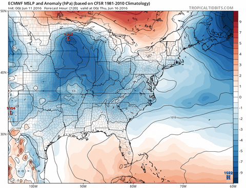
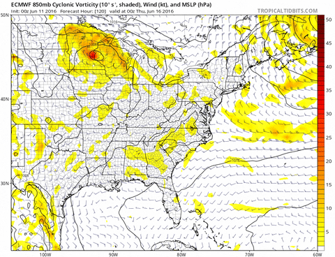
00Z GFS continues to favor the Western GOM keeping lower pressure in the BOC for days before latching on to an area and this is the look by hr 240

00Z Euro prefers a system off the SE coast which still appears frontal in this image but the Low drifts back west in the following days as High builds in behind the front.

00Z Euro prefers a system off the SE coast which still appears frontal in this image but the Low drifts back west in the following days as High builds in behind the front.
0 likes
-
stormwise
Re: 2016 Global Model Runs Discussion

The heights admons if they verify looks to be reason for the low to form.
0 likes
-
wxman57

- Moderator-Pro Met

- Posts: 23173
- Age: 68
- Joined: Sat Jun 21, 2003 8:06 pm
- Location: Houston, TX (southwest)
Re: 2016 Global Model Runs Discussion
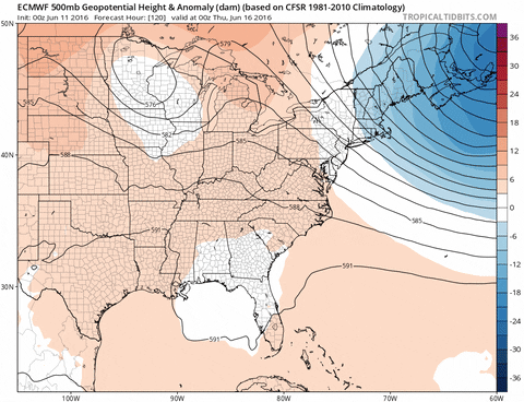
Clearly, the models are developing a frontal low along the East U.S. Coast next weekend. The question is, will it be able to disassociate itself from the cold front and develop tropical characteristics? Maybe - if it stays offshore long enough.
0 likes
Who is online
Users browsing this forum: No registered users and 341 guests