Seasonal Indicators (Beyond Day 16): Instability / SST's / MSLP / Steering / Sal
Moderator: S2k Moderators
Forum rules

The posts in this forum are NOT official forecasts and should not be used as such. They are just the opinion of the poster and may or may not be backed by sound meteorological data. They are NOT endorsed by any professional institution or STORM2K. For official information, please refer to products from the National Hurricane Center and National Weather Service.
-
Kingarabian

- S2K Supporter

- Posts: 16355
- Joined: Sat Aug 08, 2009 3:06 am
- Location: Honolulu, Hawaii
Re: 2016 indicators: Instability / SST's / MSLP / Steering / Sal
Conditions are pretty hostile right now but that hasn't stopped areas of low pressure from forming in the EPAC. CFS is showing low lower shear across the basin in the months to come and the Euro shows a favorable wet pattern.
0 likes
RIP Kobe Bryant
-
TheStormExpert
Re: 2016 indicators: Instability / SST's / MSLP / Steering / Sal
I know we are off to a record fast start thanks in part to the way off season surprise Hurricane Alex back in Mid-January. Outside of that the storms have been short-lived TS's that peak at 40-45kts. not really impressive in my opinion thought it is June 20th.
0 likes
-
USTropics
- Professional-Met

- Posts: 2738
- Joined: Sun Aug 12, 2007 3:45 am
- Location: Florida State University
Re: 2016 indicators: Instability / SST's / MSLP / Steering / Sal
TheStormExpert wrote:I know we are off to a record fast start thanks in part to the way off season surprise Hurricane Alex back in Mid-January. Outside of that the storms have been short-lived TS's that peak at 40-45kts. not really impressive in my opinion thought it is June 20th.
I would say there's been a high frequency of tropical genesis occurring in areas you would expect for June, as well as the climatological norm in terms of strength/organizational structure. This is essentially the preseason though. We'll see what happens later in the year when the focus transitions to genesis from tropical waves.
0 likes

Re: 2016 indicators: Instability / SST's / MSLP / Steering / Sal
I bet that since June 1st shear is even less compared to last year than on the image below.
https://twitter.com/philklotzbach/statu ... 2781159424
Philip Klotzbach @philklotzbach 2h2 hours ago Moraga, CA
Average vertical wind shear running 10-15 knots less from mid-May to mid-June across the Caribbean in 2016 vs. 2015
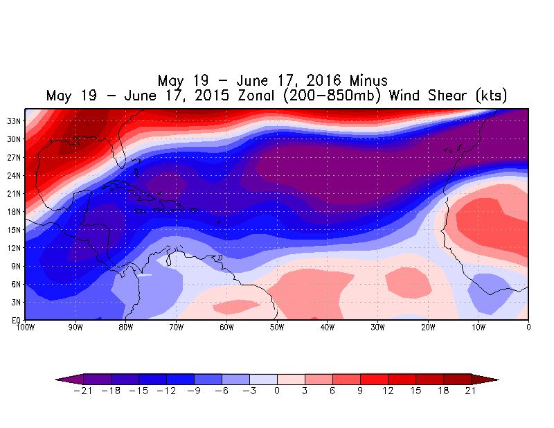
https://twitter.com/philklotzbach/statu ... 2781159424
0 likes
-
WPBWeather

- S2K Supporter
- Posts: 535
- Age: 67
- Joined: Thu Jul 18, 2013 12:33 pm
Re: 2016 indicators: Instability / SST's / MSLP / Steering / Sal
NDG wrote:I bet that since June 1st shear is even less compared to last year than on the image below.Philip Klotzbach @philklotzbach 2h2 hours ago Moraga, CA
Average vertical wind shear running 10-15 knots less from mid-May to mid-June across the Caribbean in 2016 vs. 2015
https://twitter.com/philklotzbach/statu ... 2781159424
I agree. There will probably be some revised estimates upward on this season's activity as we move along into summer.
0 likes
Re: 2016 indicators: Instability / SST's / MSLP / Steering / Sal
Caribbean/southern Gulf will continue to crank out storms as long as the monsoon trough remains on the Atlantic side of Central America
0 likes
-
TheStormExpert
Re: 2016 indicators: Instability / SST's / MSLP / Steering / Sal
The motto of the 2016 Atlantic Hurricane Season thus far, "Quantity over Quality".
Philip Klotzbach
@philklotzbach
#Danielle (max intensity of 40 knots) was weakest "D" storm in the Atlantic basin since Dean (1995 - also 40 knots).
0 likes
-
tatertawt24
- Category 1

- Posts: 309
- Joined: Wed Oct 24, 2012 12:57 pm
Re: 2016 indicators: Instability / SST's / MSLP / Steering / Sal
TheStormExpert wrote:The motto of the 2016 Atlantic Hurricane Season thus far, "Quantity over Quality".Philip Klotzbach
@philklotzbach
#Danielle (max intensity of 40 knots) was weakest "D" storm in the Atlantic basin since Dean (1995 - also 40 knots).
Reminds me of 2012 so far.
0 likes
Personal Forecast Disclaimer:
The posts in this forum are NOT official forecast and should not be used as such. They are just the opinion of the poster and may or may not be backed by sound meteorological data. They are NOT endorsed by any professional institution or storm2k.org. For official information, please refer to the NHC and NWS products.
The posts in this forum are NOT official forecast and should not be used as such. They are just the opinion of the poster and may or may not be backed by sound meteorological data. They are NOT endorsed by any professional institution or storm2k.org. For official information, please refer to the NHC and NWS products.
Re: 2016 indicators: Instability / SST's / MSLP / Steering / Sal
TheStormExpert wrote:The motto of the 2016 Atlantic Hurricane Season thus far, "Quantity over Quality".Philip Klotzbach
@philklotzbach
#Danielle (max intensity of 40 knots) was weakest "D" storm in the Atlantic basin since Dean (1995 - also 40 knots).
yet the ACE is something like 300% of average
0 likes
-
wxman57

- Moderator-Pro Met

- Posts: 23173
- Age: 68
- Joined: Sat Jun 21, 2003 8:06 pm
- Location: Houston, TX (southwest)
Re: 2016 indicators: Instability / SST's / MSLP / Steering / Sal
Normal ACE through June 21st is about 0. Total for 2016 is 6.8. Hard to say that's 300%, but it's higher than normal. 
0 likes
Re: 2016 indicators: Instability / SST's / MSLP / Steering / Sal
TheStormExpert wrote:The motto of the 2016 Atlantic Hurricane Season thus far, "Quantity over Quality".Philip Klotzbach
@philklotzbach
#Danielle (max intensity of 40 knots) was weakest "D" storm in the Atlantic basin since Dean (1995 - also 40 knots).
I think the season is just getting warmed up myself but have to see though.
0 likes
-
weathaguyry

- Category 5

- Posts: 1273
- Age: 22
- Joined: Wed Jun 15, 2016 5:16 am
- Location: Long Island, NY
Re: 2016 indicators: Instability / SST's / MSLP / Steering / Sal
Well, if anything, every single storm so far has made landfall (Well, I'm not so positive that Alex made a direct landfall on one of the Islands) but anyway, in 2012 both Alberto and Chris made no landfall
0 likes
My posts are only my opinions and NOT official forecasts. For official forecasts, consult the National Hurricane Center or the National Weather Service.
Irene 11', Sandy 12', Fay 20’, Isaias 20’, Elsa 21’, Henri 21’, Ida 21’
Irene 11', Sandy 12', Fay 20’, Isaias 20’, Elsa 21’, Henri 21’, Ida 21’
-
SFLcane

- S2K Supporter
- Posts: 10281
- Age: 48
- Joined: Sat Jun 05, 2010 1:44 pm
- Location: Lake Worth Florida
Re: 2016 indicators: Instability / SST's / MSLP / Steering / Sal
IF shear remains below normal in the Caribbean into july odds are higher for a busy season per Phil k. Interesting times ahead for sure.

Phil k on twitter...
Caribbean shear in July one of strongest predictors for overall seasonal Atlantic basin hurricane activity.

Phil k on twitter...
Caribbean shear in July one of strongest predictors for overall seasonal Atlantic basin hurricane activity.
0 likes
-
SFLcane
- S2K Supporter
- Posts: 10281
- Age: 48
- Joined: Sat Jun 05, 2010 1:44 pm
- Location: Lake Worth Florida
Re: 2016 indicators: Instability / SST's / MSLP / Steering / Sal
@MichealRlowry this morning... 
What a difference a year (or two) makes. So far tropical Atlantic/Caribbean shear strikingly lower than 2015 or 2014.


What a difference a year (or two) makes. So far tropical Atlantic/Caribbean shear strikingly lower than 2015 or 2014.
0 likes
-
TheStormExpert
Re: 2016 indicators: Instability / SST's / MSLP / Steering / Sal
Seems like things are now leaning towards an active season compared to an inactive one like 2013.

0 likes
Re: 2016 indicators: Instability / SST's / MSLP / Steering / Sal
TheStormExpert wrote::uarrow: Saw those graphics a couple times earlier on Twitter and was thinking wow, what an improvment over the past year! This right here explains why there have been several TW's making it all away to the Western Caribbean(including the one that spawned Danielle). There should be MANY MORE to come at this rate if trends continue.
Seems like things are now leaning towards an active season compared to an inactive one like 2013.
Yes maybe, but time will tell. A few tropical storms of 40-60mph isn't all that significant- strength means more than number. If we get a couple major hurricanes in July, then that would be much more likely to point toward an active season. Correlation between number of tropical storms in June and season total is not that strong.
If I had to guess, I would say that we end up with 13-16 named storms for this season.
0 likes
All posts by Dean_175 are NOT official forecasts and should not be used as such. They are just the opinion of the poster and may or may not be backed by sound meteorological data. They are NOT endorsed by any professional institution or storm2k.org. For official information, please refer to the NHC and NWS products.
-
TheStormExpert
Re: 2016 indicators: Instability / SST's / MSLP / Steering / Sal
The steering pattern at the moment is very similar to that of most of 2010/2011 with an persistent East Coast trough which would recurve anything that tries to strike the U.S. from the East or Southeast. Then there is the Texas Death Ridge(which started their bad drought from a few years ago) which would shove anything that tries to sneak in from the Western Caribbean into Central America or Mexico.
0 likes

Re: 2016 indicators: Instability / SST's / MSLP / Steering / Sal
Dean_175 wrote:A few tropical storms of 40-60mph isn't all that significant- strength means more than number. If we get a couple major hurricanes in July, then that would be much more likely to point toward an active season. Correlation between number of tropical storms in June and season total is not that strong
On their own, none of the three that formed the last few weeks were atypical for this time of year--most June storms are weak. What makes it unusual is that we had three such storms in such a short period of time. And while not necessarily an indicator, add this with the fact that the upper air conditions, moisture, and SSTs are far more favorable than the last few years (which still managed to be relatively productive seasons when El Nino is taken into account) and you start having signs of a potentially busier season. The fact that they were weak though I don't see as indicating anything, nor do we need major hurricanes in July--having one before August at all is incredibly rare.
TheStormExpert wrote:The steering pattern at the moment is very similar to that of most of 2010/2011 with an persistent East Coast trough which would recurve anything that tries to strike the U.S. from the East or Southeast. Then there is the Texas Death Ridge(which started their bad drought from a few years ago) which would shove anything that tries to sneak in from the Western Caribbean into Central America or Mexico.
Even landfall-heavy 2004-05 (and most other years for that matter) had troughs along and off the East Coast in June and in many cases the first half of July, so like the low intensity of the storms, this also does not indicate anything.
0 likes
The above post is not official and should not be used as such. It is the opinion of the poster and may or may not be backed by sound meteorological data. It is not endorsed by any professional institution or storm2k.org. For official information, please refer to the NHC and NWS products.
-
CFLHurricane

- Category 1
- Posts: 349
- Joined: Thu Mar 27, 2014 5:56 pm
- Location: Floriduh
Re: 2016 indicators: Instability / SST's / MSLP / Steering / Sal
Hammy wrote:Dean_175 wrote:A few tropical storms of 40-60mph isn't all that significant- strength means more than number. If we get a couple major hurricanes in July, then that would be much more likely to point toward an active season. Correlation between number of tropical storms in June and season total is not that strong
On their own, none of the three that formed the last few weeks were atypical for this time of year--most June storms are weak. What makes it unusual is that we had three such storms in such a short period of time. And while not necessarily an indicator, add this with the fact that the upper air conditions, moisture, and SSTs are far more favorable than the last few years (which still managed to be relatively productive seasons when El Nino is taken into account) and you start having signs of a potentially busier season. The fact that they were weak though I don't see as indicating anything, nor do we need major hurricanes in July--having one before August at all is incredibly rare.TheStormExpert wrote:The steering pattern at the moment is very similar to that of most of 2010/2011 with an persistent East Coast trough which would recurve anything that tries to strike the U.S. from the East or Southeast. Then there is the Texas Death Ridge(which started their bad drought from a few years ago) which would shove anything that tries to sneak in from the Western Caribbean into Central America or Mexico.
Even landfall-heavy 2004-05 (and most other years for that matter) had troughs along and off the East Coast in June and in many cases the first half of July, so like the low intensity of the storms, this also does not indicate anything.
Thank you hammy for this eloquent explanation in response to the "east coast trof" camp. I am in concurrence that this will likely be a busier season, especially if July has some bonified hurricanes.
0 likes
I'm not a meteorologist, but I did stay at a motel 8.
Re: 2016 indicators: Instability / SST's / MSLP / Steering / Sal
An East Coast trough will usually take something in the open Atlantic and turn it out to sea. An east coast trough will also take a Caribbean storm and turn it into the GOM.
The Caribbean has been really quiet lately. If theres a major hurricane in there, an east coast trough will not be good for the US.
The Caribbean has been really quiet lately. If theres a major hurricane in there, an east coast trough will not be good for the US.
0 likes
Who is online
Users browsing this forum: mixedDanilo.E and 195 guests