2016 Global Model Runs Discussion (Out to Day 16)
Moderator: S2k Moderators
Forum rules

The posts in this forum are NOT official forecasts and should not be used as such. They are just the opinion of the poster and may or may not be backed by sound meteorological data. They are NOT endorsed by any professional institution or STORM2K. For official information, please refer to products from the National Hurricane Center and National Weather Service.
-
stormlover2013
Re: 2016 Global Model Runs Discussion
Will be interesting if gfs sniffed it out this far out, wish euro would go this far out
0 likes
-
Yellow Evan

- Professional-Met

- Posts: 16232
- Age: 27
- Joined: Fri Jul 15, 2011 12:48 pm
- Location: Henderson, Nevada/Honolulu, HI
- Contact:
Re: 2016 Global Model Runs Discussion
GfS isn't bringing the timeframe of landfall down much, but tbf the track its been showing has it moving slower across the BOC and the Yuacatan and then moving N rather than racing off the the NE.
0 likes
-
Yellow Evan
- Professional-Met
- Posts: 16232
- Age: 27
- Joined: Fri Jul 15, 2011 12:48 pm
- Location: Henderson, Nevada/Honolulu, HI
- Contact:
Re: 2016 Global Model Runs Discussion
stormlover2013 wrote:Will be interesting if gfs sniffed it out this far out, wish euro would go this far out
ECMWF goes out to 10 days and hasn't shown anything, even though the GFS has a system over the Yucatan at that time.
The EPS ensembles do go out to day 15 and they have only a few of the 51 members seem to show anything.
0 likes
-
cycloneye

- Admin

- Posts: 149405
- Age: 69
- Joined: Thu Oct 10, 2002 10:54 am
- Location: San Juan, Puerto Rico
Re: 2016 Global Model Runs Discussion
FIM-8 is on board.

0 likes
Visit the Caribbean-Central America Weather Thread where you can find at first post web cams,radars
and observations from Caribbean basin members Click Here
and observations from Caribbean basin members Click Here
-
srainhoutx

- S2K Supporter

- Posts: 6919
- Age: 68
- Joined: Sun Jan 14, 2007 11:34 am
- Location: Haywood County, NC
- Contact:
Re: 2016 Global Model Runs Discussion
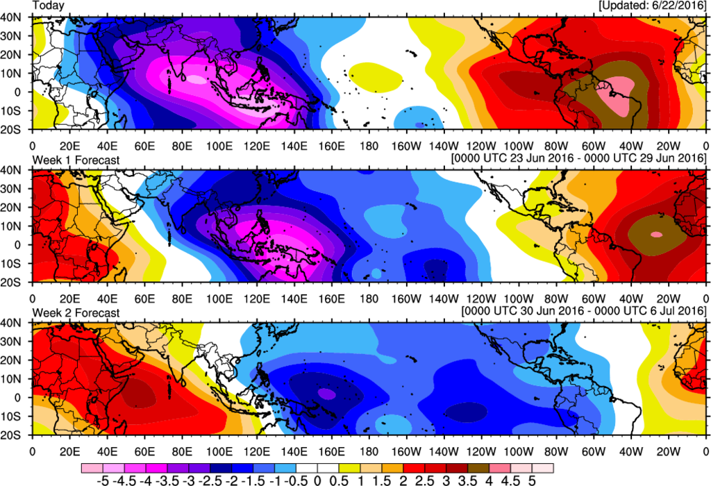
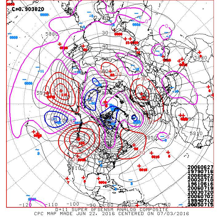
Beginning to see some rather impressive Ensemble support for the possibility of Tropical Cyclone Genesis across the NW Caribbean as the robust MJO pulse arrives. Also, the Day 11+ Analogs offer some interesting dates that coincide with a favorable Upper Air pattern during that time.
0 likes
Carla/Alicia/Jerry(In The Eye)/Michelle/Charley/Ivan/Dennis/Katrina/Rita/Wilma/Ike/Harvey
Member: National Weather Association
Wx Infinity Forums
http://wxinfinity.com/index.php
Facebook.com/WeatherInfinity
Twitter @WeatherInfinity
Member: National Weather Association
Wx Infinity Forums
http://wxinfinity.com/index.php
Facebook.com/WeatherInfinity
Twitter @WeatherInfinity
-
cycloneye
- Admin
- Posts: 149405
- Age: 69
- Joined: Thu Oct 10, 2002 10:54 am
- Location: San Juan, Puerto Rico
Re: 2016 Global Model Runs Discussion
What MV said did not lasted long. 
Michael Ventrice @MJVentrice · 2h2 hours ago
I'm very happy to see not one of the folks I'm following post a hour 336 forecast map from the 12Z GFS op. Bravo.
Eric Webb @webberweather · 16m16 minutes ago
@EricBlake12 @MJVentrice Yea, so much for that... #oops #wxporn : P
Eric Blake
@EricBlake12
@webberweather @MJVentrice usually isn't just the map is the issue -- it's the added drama or hype
0 likes
Visit the Caribbean-Central America Weather Thread where you can find at first post web cams,radars
and observations from Caribbean basin members Click Here
and observations from Caribbean basin members Click Here
Re: 2016 Global Model Runs Discussion
TropicalAnalystwx13 wrote:Alyono wrote:12Z MU basically goes full Katrina
I needed that good laugh today. That's not going to happen
...what? It shows a Category 1 hurricane making landfall, in no way comparable to Katrina.
if you think ~980mb in the low resolution is a cat 1, I have some property back in Indonesia near a polluted river to sell you for a million USD
0 likes
-
tarheelprogrammer

- S2K Supporter
- Posts: 1793
- Joined: Mon Mar 28, 2016 9:25 pm
- Location: Raleigh, NC area (Garner, NC)
Re: 2016 Global Model Runs Discussion
So, GFS/NAVGEM vs ECMWF/CMC. Stay tuned to see which group wins the battle lol. Personally I think the GFS is right but only on genesis and not on strength. Thinking a low end hurricane at best if it develops.
0 likes
My posts are not official forecasts. They are just my opinion and may or may not be backed by sound meteorological data. They are NOT endorsed by any professional institution or storm2k.org. For official information, please refer to the NHC and NWS products.
-
TheStormExpert
Re: 2016 Global Model Runs Discussion
tarheelprogrammer wrote:So, GFS/NAVGEM vs ECMWF/CMC. Stay tuned to see which group wins the battle lol. Personally I think the GFS is right but only on genesis and not on strength. Thinking a low end hurricane at best if it develops.
That is what the 12z GFS showed at landfall in SE Louisiana a Cat.1 hurricane.
0 likes
-
StormHunter72
- Tropical Storm

- Posts: 166
- Joined: Wed May 25, 2016 6:36 am
- Location: Nature Coast
Re: 2016 Global Model Runs Discussion
Until the Euro shows something it is a phantom
0 likes
The following post is NOT an official forecast and should not be used as such. It is just the opinion of the poster and may or may not be backed by sound meteorological data. It is NOT endorsed by any professional institution including storm2k.org For Official Information please refer to the NHC and NWS products.
Re: 2016 Global Model Runs Discussion
TheStormExpert wrote:tarheelprogrammer wrote:So, GFS/NAVGEM vs ECMWF/CMC. Stay tuned to see which group wins the battle lol. Personally I think the GFS is right but only on genesis and not on strength. Thinking a low end hurricane at best if it develops.
That is what the 12z GFS showed at landfall in SE Louisiana a Cat.1 hurricane.
980mb 330 hours out would probably be a high 2 or 3.
0 likes
-
tarheelprogrammer
- S2K Supporter
- Posts: 1793
- Joined: Mon Mar 28, 2016 9:25 pm
- Location: Raleigh, NC area (Garner, NC)
Re: 2016 Global Model Runs Discussion
TheStormExpert wrote:tarheelprogrammer wrote:So, GFS/NAVGEM vs ECMWF/CMC. Stay tuned to see which group wins the battle lol. Personally I think the GFS is right but only on genesis and not on strength. Thinking a low end hurricane at best if it develops.
That is what the 12z GFS showed at landfall in SE Louisiana a Cat.1 hurricane.
Yeah I know but I think that is a max and not what it will end up being. Probably a long tracking strong tropical storm.
0 likes
My posts are not official forecasts. They are just my opinion and may or may not be backed by sound meteorological data. They are NOT endorsed by any professional institution or storm2k.org. For official information, please refer to the NHC and NWS products.
-
tropicwatch

- Category 5

- Posts: 3426
- Age: 62
- Joined: Sat Jun 02, 2007 10:01 am
- Location: The Villages, Florida
- Contact:
Re: 2016 Global Model Runs Discussion
StormHunter72 wrote:Until the Euro shows something it is a phantom
The GFS sniffed out Danielle pretty early and the euro was slow to hop on board.
0 likes
Tropicwatch
Agnes 72', Eloise 75, Elena 85', Kate 85', Charley 86', Florence 88', Beryl 94', Dean 95', Erin 95', Opal 95', Earl 98', Georges 98', Ivan 2004', Arlene 2005', Dennis 2005', Ida 2009' Debby 2012' Irma 2017' Michael 2018'
Agnes 72', Eloise 75, Elena 85', Kate 85', Charley 86', Florence 88', Beryl 94', Dean 95', Erin 95', Opal 95', Earl 98', Georges 98', Ivan 2004', Arlene 2005', Dennis 2005', Ida 2009' Debby 2012' Irma 2017' Michael 2018'
-
cycloneye
- Admin
- Posts: 149405
- Age: 69
- Joined: Thu Oct 10, 2002 10:54 am
- Location: San Juan, Puerto Rico
Re: 2016 Global Model Runs Discussion
Levi Cowan chims on this.
Levi Cowan @TropicalTidbits · 33m33 minutes ago
@TropicsWatch @MJVentrice I'm very skeptical until I see the vorticity source come from somewhere other than Venezuela on the GFS.
Levi Cowan @TropicalTidbits · 33m33 minutes ago
@TropicsWatch @MJVentrice I'm very skeptical until I see the vorticity source come from somewhere other than Venezuela on the GFS.
0 likes
Visit the Caribbean-Central America Weather Thread where you can find at first post web cams,radars
and observations from Caribbean basin members Click Here
and observations from Caribbean basin members Click Here
-
tarheelprogrammer
- S2K Supporter
- Posts: 1793
- Joined: Mon Mar 28, 2016 9:25 pm
- Location: Raleigh, NC area (Garner, NC)
Re: 2016 Global Model Runs Discussion
panamatropicwatch wrote:StormHunter72 wrote:Until the Euro shows something it is a phantom
The GFS sniffed out Danielle pretty early and the euro was slow to hop on board.
ECMWF never came on board it showed nothing pretty much there up until landfall. I am not saying it is wrong here but it is not perfect.
0 likes
My posts are not official forecasts. They are just my opinion and may or may not be backed by sound meteorological data. They are NOT endorsed by any professional institution or storm2k.org. For official information, please refer to the NHC and NWS products.
-
TheStormExpert
Re: 2016 Global Model Runs Discussion
Wind field shows winds of strong TS or weak Cat.1 though.RL3AO wrote:TheStormExpert wrote:tarheelprogrammer wrote:So, GFS/NAVGEM vs ECMWF/CMC. Stay tuned to see which group wins the battle lol. Personally I think the GFS is right but only on genesis and not on strength. Thinking a low end hurricane at best if it develops.
That is what the 12z GFS showed at landfall in SE Louisiana a Cat.1 hurricane.
980mb 330 hours out would probably be a high 2 or 3.
0 likes
-
wxman57

- Moderator-Pro Met

- Posts: 23173
- Age: 68
- Joined: Sat Jun 21, 2003 8:06 pm
- Location: Houston, TX (southwest)
Re: 2016 Global Model Runs Discussion
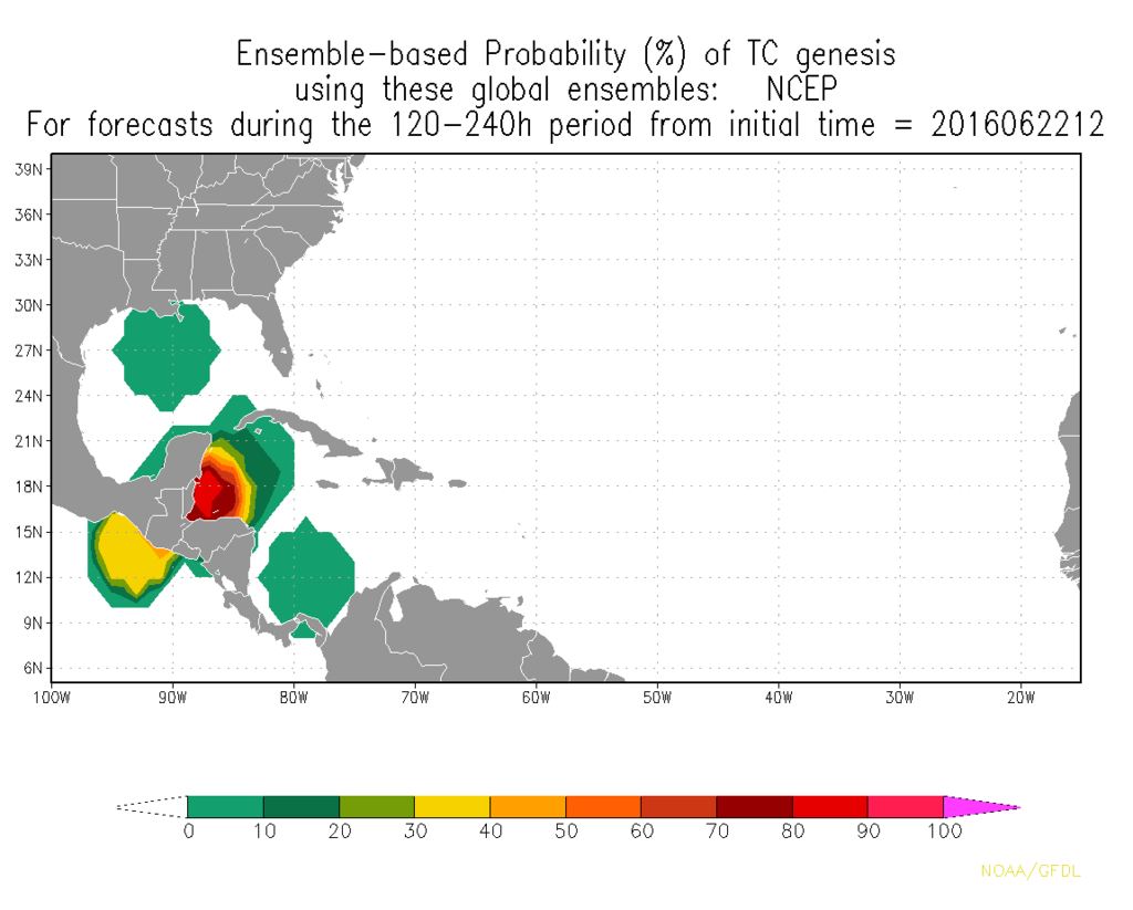
srainhoutx wrote:Beginning to see some rather impressive Ensemble support for the possibility of Tropical Cyclone Genesis across the NW Caribbean as the robust MJO pulse arrives. Also, the Day 11+ Analogs offer some interesting dates that coincide with a favorable Upper Air pattern during that time.
http://i228.photobucket.com/albums/ee29 ... 20_240.png
That genesis probability map only includes GFS ensembles, apparently. However, they've been indicating a significant low pressure anomaly in the western Caribbean late next week.
There is also a CCKW (Convectively-Coupled Kelvin Wave) that will be passing through the region late next week. It could enhance development potential in the western Caribbean.
0 likes
-
stormlover2013
Re: 2016 Global Model Runs Discussion
Euro don't go 280 hours out !!! That's why it's not showing anything
0 likes
Re: 2016 Global Model Runs Discussion
tarheelprogrammer wrote:panamatropicwatch wrote:StormHunter72 wrote:Until the Euro shows something it is a phantom
The GFS sniffed out Danielle pretty early and the euro was slow to hop on board.
ECMWF never came on board it showed nothing pretty much there up until landfall. I am not saying it is wrong here but it is not perfect.
EC was showing Danielle several days in advance. At least the full, 150K+ ECMWF was showing a depression at landfall several days prior to genesis
0 likes
Who is online
Users browsing this forum: NotSparta and 201 guests