000
ABPZ20 KNHC 260504
TWOEP
TROPICAL WEATHER OUTLOOK
NWS NATIONAL HURRICANE CENTER MIAMI FL
1100 PM PDT SAT JUN 25 2016
For the eastern North Pacific...east of 140 degrees west longitude:
Disorganized showers and thunderstorm continue near an elongated
area of low pressure located about 1350 miles southwest of the
southern tip of the Baja California peninsula. Environmental
conditions are not conducive for development during the next day
or two, and any development early next week should be slow to
occur while the low moves to the west or west-northwest at 10-15
mph.
* Formation chance through 48 hours...low...near 0 percent
* Formation chance through 5 days...low...10 percent
$$
Forecaster Beven
2016 EPAC Season
Moderator: S2k Moderators
Forum rules

The posts in this forum are NOT official forecasts and should not be used as such. They are just the opinion of the poster and may or may not be backed by sound meteorological data. They are NOT endorsed by any professional institution or STORM2K. For official information, please refer to products from the National Hurricane Center and National Weather Service.
-
Yellow Evan

- Professional-Met

- Posts: 16240
- Age: 27
- Joined: Fri Jul 15, 2011 12:48 pm
- Location: Henderson, Nevada/Honolulu, HI
- Contact:
-
Kingarabian

- S2K Supporter

- Posts: 16366
- Joined: Sat Aug 08, 2009 3:06 am
- Location: Honolulu, Hawaii
Re: 2016 EPAC Season
And it's really weak from the 00z Euro @ 144hrs.
But it's rather a large system.
Begins to re-strengthen the system @ 240 hours. Looks like there's another system right next to it that may be the reason for keeping it weak.
But it's rather a large system.
Begins to re-strengthen the system @ 240 hours. Looks like there's another system right next to it that may be the reason for keeping it weak.
0 likes
RIP Kobe Bryant

-
Kingarabian
- S2K Supporter
- Posts: 16366
- Joined: Sat Aug 08, 2009 3:06 am
- Location: Honolulu, Hawaii
Re: 2016 EPAC Season
Euro ensembles are more bullish than the operational model.
GFS is in full over achiever mode.
GFS is in full over achiever mode.
0 likes
RIP Kobe Bryant
-
Yellow Evan
- Professional-Met
- Posts: 16240
- Age: 27
- Joined: Fri Jul 15, 2011 12:48 pm
- Location: Henderson, Nevada/Honolulu, HI
- Contact:
Re: 2016 EPAC Season
000
ABPZ20 KNHC 261140
TWOEP
TROPICAL WEATHER OUTLOOK
NWS NATIONAL HURRICANE CENTER MIAMI FL
500 AM PDT SUN JUN 26 2016
For the eastern North Pacific...east of 140 degrees west longitude:
An elongated area of low pressure located about 1450 miles southwest
of the southern tip of the Baja California peninsula is producing
limited shower activity. Environmental conditions are not conducive
for development and tropical cyclone formation is unlikely during
the next several days while the low moves westward at about 15 mph.
* Formation chance through 48 hours...low...near 0 percent
* Formation chance through 5 days...low...near 0 percent
$$
Forecaster Stewart
0 likes
-
Yellow Evan
- Professional-Met
- Posts: 16240
- Age: 27
- Joined: Fri Jul 15, 2011 12:48 pm
- Location: Henderson, Nevada/Honolulu, HI
- Contact:


-
Yellow Evan
- Professional-Met
- Posts: 16240
- Age: 27
- Joined: Fri Jul 15, 2011 12:48 pm
- Location: Henderson, Nevada/Honolulu, HI
- Contact:
-
cycloneye

- Admin

- Posts: 149508
- Age: 69
- Joined: Thu Oct 10, 2002 10:54 am
- Location: San Juan, Puerto Rico
Re: 2016 EPAC Season
12z ECMWF:

0 likes
Visit the Caribbean-Central America Weather Thread where you can find at first post web cams,radars
and observations from Caribbean basin members Click Here
and observations from Caribbean basin members Click Here
-
Kingarabian
- S2K Supporter
- Posts: 16366
- Joined: Sat Aug 08, 2009 3:06 am
- Location: Honolulu, Hawaii
Re: 2016 EPAC Season
12z Euro back to showing a strong TS. 996mb.
12z EPS stronger as well.
12z EPS stronger as well.
0 likes
RIP Kobe Bryant
-
cycloneye
- Admin
- Posts: 149508
- Age: 69
- Joined: Thu Oct 10, 2002 10:54 am
- Location: San Juan, Puerto Rico
Re: 2016 EPAC Season
18z GFS is strong with a cat 1 going to 2.NHC should begin to mention it very soon.
0 likes
Visit the Caribbean-Central America Weather Thread where you can find at first post web cams,radars
and observations from Caribbean basin members Click Here
and observations from Caribbean basin members Click Here
-
Yellow Evan
- Professional-Met
- Posts: 16240
- Age: 27
- Joined: Fri Jul 15, 2011 12:48 pm
- Location: Henderson, Nevada/Honolulu, HI
- Contact:
Re: 2016 EPAC Season
cycloneye wrote:18z GFS is strong with a cat 1 going to 2.NHC should begin to mention it very soon.
Has it at 953mbar at 228 hours out.
0 likes
-
Kingarabian
- S2K Supporter
- Posts: 16366
- Joined: Sat Aug 08, 2009 3:06 am
- Location: Honolulu, Hawaii
Re: 2016 EPAC Season
If this system fails to develop then I'll be in season cancel mode.
Because this would literally be the 3rd system out of 4 to not form after being modeled and projected to form.
That being said, if this system forms then it looks like it'll add a healthy amount of ACE.
Because this would literally be the 3rd system out of 4 to not form after being modeled and projected to form.
That being said, if this system forms then it looks like it'll add a healthy amount of ACE.
0 likes
RIP Kobe Bryant
-
stormwise
Re: 2016 EPAC Season
Anything modeled out past 110hrs is likely 
If this plot is correct the PDO is looking coolish now.

If this plot is correct the PDO is looking coolish now.
0 likes
-
1900hurricane

- Category 5

- Posts: 6063
- Age: 34
- Joined: Fri Feb 06, 2015 12:04 pm
- Location: Houston, TX
- Contact:
Re: 2016 EPAC Season
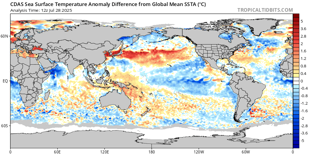
Not yet per CDAS analysis. While perhaps not as staunch as previously, the anomalous warm water horseshoe backed against the North American continent associated with a +PDO regime is still rather noticeable.
0 likes
Contract Meteorologist. TAMU & MSST. Fiercely authentic, one of a kind. We are all given free will, so choose a life meant to be lived. We are the Masters of our own Stories.
Opinions expressed are mine alone.
Follow me on Twitter at @1900hurricane : Read blogs at https://1900hurricane.wordpress.com/
Opinions expressed are mine alone.
Follow me on Twitter at @1900hurricane : Read blogs at https://1900hurricane.wordpress.com/
Re: 2016 EPAC Season
I wouldn't really say that the PDO has flipped until the area north of Hawai'i is consistently warm. Although it is definitely a much weaker signal than it was in the past months, especially April.
0 likes

-
stormwise
Re: 2016 EPAC Season
removed chart.
Last edited by stormwise on Sun Jun 26, 2016 10:16 pm, edited 1 time in total.
0 likes
-
Kingarabian
- S2K Supporter
- Posts: 16366
- Joined: Sat Aug 08, 2009 3:06 am
- Location: Honolulu, Hawaii
Re: 2016 EPAC Season
I think you're looking at the SST values rather than the anomalies which correctly display the warm horseshoe.
SST's by Alaska are for sure super cold.
SST's by Alaska are for sure super cold.
0 likes
RIP Kobe Bryant
-
1900hurricane
- Category 5
- Posts: 6063
- Age: 34
- Joined: Fri Feb 06, 2015 12:04 pm
- Location: Houston, TX
- Contact:
Re: 2016 EPAC Season
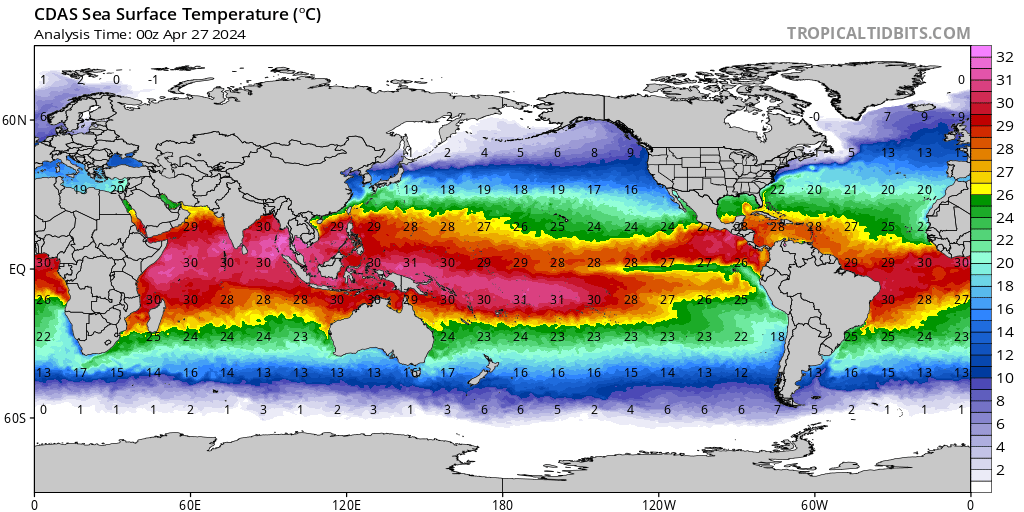
If you'd rather, here are are SSTAs relative to 1980-2010 climatology, although I prefer using the other one because you can see specific features better when they aren't all washed out by warm anomalies.

Equatorial Indian Ocean temps west of 60*E are only hanging out around 26*C on your WeatherBell (if I'm not mistaken) analysis, which isn't particularly warm for the tropics. These values also line up very nicely with the CDAS SST analysis from Tropical Tidbits.
Equatorial Indian Ocean temps west of 60*E are only hanging out around 26*C on your WeatherBell (if I'm not mistaken) analysis, which isn't particularly warm for the tropics. These values also line up very nicely with the CDAS SST analysis from Tropical Tidbits.
0 likes
Contract Meteorologist. TAMU & MSST. Fiercely authentic, one of a kind. We are all given free will, so choose a life meant to be lived. We are the Masters of our own Stories.
Opinions expressed are mine alone.
Follow me on Twitter at @1900hurricane : Read blogs at https://1900hurricane.wordpress.com/
Opinions expressed are mine alone.
Follow me on Twitter at @1900hurricane : Read blogs at https://1900hurricane.wordpress.com/
-
stormwise
Re: 2016 EPAC Season
I actually forgot its against the the rules to post a weatherbell grafic you alerted to here. Although not sure you did. 

BOMS plot.
BOMS plot.
Last edited by stormwise on Mon Jun 27, 2016 4:35 am, edited 2 times in total.
0 likes
Who is online
Users browsing this forum: hurricanes1234 and 225 guests