Seasonal Indicators (Beyond Day 16): Instability / SST's / MSLP / Steering / Sal
Moderator: S2k Moderators
Forum rules

The posts in this forum are NOT official forecasts and should not be used as such. They are just the opinion of the poster and may or may not be backed by sound meteorological data. They are NOT endorsed by any professional institution or STORM2K. For official information, please refer to products from the National Hurricane Center and National Weather Service.

Re: Seasonal Indicators (Beyond Day 16): Instability / SST's / MSLP / Steering / Sal
0 likes
Georges '98, Irene '99, Frances '04, Jeanne '04, Katrina '05, Wilma '05, Gustav '08, Isaac '12, Matthew '16, Florence '18, Michael '18, Ian '22

Re: Seasonal Indicators (Beyond Day 16): Instability / SST's / MSLP / Steering / Sal
Just a couple of additional observations while just now looking at the 12Z GFS run. While the two or three apparant T.S. appearing toward the "wishful thinking" range of the GFS now appear to have dropped, I see this as nothing more than a model still trying to measure out details that are way far out. Actually, I'm rather expecting these or different features to pop up again for that approx. time frame and sooner, while also becoming more consistantly maintained through its continually updated forecast runs.
Surface flow - I was pretty impressed and not sure I remember such a consistant deep surface flow from the E. Pacific and south of Panama, being carried north and northeastward into the S.W. Caribbean, for the entirety of the model run. That's quite a bit of healthy convergence and maybe suggests an increasingly northward push of the ITCZ over time there? Also interesting was how strong an expanding cross-equatorial southerly flow seemed to be occuring at around 150 hours, in the far Eastern Atlantic just west of the W. African coast. In fact, this deep Northward moving inflow originating from south of the equator, seems to expand westward to at least 40W over time.
Somewhere around 180 hours, model runs seem to indicate a monsoonal low to begin and lumber off the African coast. While model support does not indicate obvious development, I'm guessing we'll begin to see a train of waves beginning around that time with possibly the larger monsoonal low itself finally dropping into the ITCZ or maybe immediately develop sometime around or after the 20th of the month.
Upper level - One think i'm NOT seeing, are those seemingly stagnant east coast TUTT features, mid-Atlantic troughs, and especially any continual flow of low latitude westerlies. In fact, the overall 200mb flow seems to be very cellular and especially progressive. This less stagnant and "troughy" flow would seem to be far more conducive to tropical cyclogenesis and certainly less disruptive to developing or fully developed tropical systems.
Mid level - Funny how model run forecasts can so easily change from run to run and they'll likely continue to do so, however I might have misspoken in my previous post (above) regarding the long wave pattern. No doubt that the east coast trough seemingly becomes less prominent with time and especially as 500mb high pressure builds northward into the Great Lakes region over time. Its only one model run but the 12Z seems to even further expand the Great Lakes high eastward as well, and perhaps indicating an eastward shift of the long wave pattern? Will be curious to see how subsequent runs and the EURO evolve those features and overall steering flow.
0 likes
Andy D
(For official information, please refer to the NHC and NWS products.)
(For official information, please refer to the NHC and NWS products.)
Re: Seasonal Indicators (Beyond Day 16): Instability / SST's / MSLP / Steering / Sal
PTrackerLA wrote:I'm curious to see if there's any correlation with the Epac possibly threatening the record of 7 named storms in July (1985) and upcoming Atlantic activity. As we all know 1985 was a high impact year for the USA with six hurricane landfalls. 1985 also got off to somewhat of a slow start as well.
That's an interesting thought. Of course there will be those to quickly point out the fact that our Atlantic season was in fact "early" and active with 4 named storms thus far. I'm kind of looking at it from a different perspective though. To me, thoses storms which have developed prior to this point might have well been influenced by altogether different waning El Nino conditions. Those conditions no longer seem to exist and we're now basically in our typical July holding pattern and watching to see how long and how quickly the typical July Atlantic dust bowl conditions will disperse. Not unlike many typical Atlantic hurricane seasons though, the real season doesnt begin until late July. I think tropical storms will have far less resemblance to the few storms that formed thus far; I'm pretty sure that overall atmospheric conditions are in the midst of transitioning now and will look a good deal more juicy in 1-2 weeks.
1 likes
Andy D
(For official information, please refer to the NHC and NWS products.)
(For official information, please refer to the NHC and NWS products.)
-
tarheelprogrammer

- S2K Supporter

- Posts: 1793
- Joined: Mon Mar 28, 2016 9:25 pm
- Location: Raleigh, NC area (Garner, NC)
Re: Seasonal Indicators (Beyond Day 16): Instability / SST's / MSLP / Steering / Sal
Nice waves on the African continent or at least soon to be waves. These could help bring an end to the SAL currently infesting the Atlantic. 

0 likes
My posts are not official forecasts. They are just my opinion and may or may not be backed by sound meteorological data. They are NOT endorsed by any professional institution or storm2k.org. For official information, please refer to the NHC and NWS products.

Re: Seasonal Indicators (Beyond Day 16): Instability / SST's / MSLP / Steering / Sal
tarheelprogrammer wrote:Nice waves on the African continent or at least soon to be waves. These could help bring an end to the SAL currently infesting the Atlantic.
Slowly but surely, the waves seem to be moistening up slightly, with each batch coming off producing slightly more spin/convection than the previous. It's still fairly likely that this convection will manage it's way to the coast by the end of the month--another 1998 type setup (Alex was preceded by continuous SAL outbreaks) with nothing until the end of July, except we're already four storms ahead of 1998.
1 likes
The above post is not official and should not be used as such. It is the opinion of the poster and may or may not be backed by sound meteorological data. It is not endorsed by any professional institution or storm2k.org. For official information, please refer to the NHC and NWS products.
-
stormwise
Re: Seasonal Indicators (Beyond Day 16): Instability / SST's / MSLP / Steering / Sal

It changes out there the 594-97 breaks down.
0 likes
Re: Seasonal Indicators (Beyond Day 16): Instability / SST's / MSLP / Steering / Sal
0 likes
Andy D
(For official information, please refer to the NHC and NWS products.)
(For official information, please refer to the NHC and NWS products.)
-
stormwise
Re: Seasonal Indicators (Beyond Day 16): Instability / SST's / MSLP / Steering / Sal
chaser1 wrote::uarrow:
Nothing detailed and complicated on the plot, just shows the blocking high broken down over that period, thus lower pressure's one would think will be over the MDR.
0 likes
Re: Seasonal Indicators (Beyond Day 16): Instability / SST's / MSLP / Steering / Sal
I see your point regarding the falling mid level heights and anticipating that surface pressures will follow suit. I was kind of interpreting that you were indicating a break in the 500mb ridge was occuring , which my progression of thought was that tropical systems to form at or east of that longitude, will simply turn poleward. That itself didnt make too much sense to me given the fact that this likely only represented a snapshot in time and that the 500mb ridging over the Eastern Atlantic, would likely prove fairly solid as Climo would typically suggest.
0 likes
Andy D
(For official information, please refer to the NHC and NWS products.)
(For official information, please refer to the NHC and NWS products.)
-
tarheelprogrammer
- S2K Supporter
- Posts: 1793
- Joined: Mon Mar 28, 2016 9:25 pm
- Location: Raleigh, NC area (Garner, NC)
Re: Seasonal Indicators (Beyond Day 16): Instability / SST's / MSLP / Steering / Sal
Tropical wave coming off Africa right now has some strong vorticity. Seems as if each wave is a little stronger. Environment looks to get a little better in the future. Will be interesting if shear does drop in the future along with dry air.
0 likes
My posts are not official forecasts. They are just my opinion and may or may not be backed by sound meteorological data. They are NOT endorsed by any professional institution or storm2k.org. For official information, please refer to the NHC and NWS products.
-
SFLcane

- S2K Supporter
- Posts: 10281
- Age: 48
- Joined: Sat Jun 05, 2010 1:44 pm
- Location: Lake Worth Florida
Re: Seasonal Indicators (Beyond Day 16): Instability / SST's / MSLP / Steering / Sal
.....Wxman57 below in models thread.....
I don't see too much changing in the next 2 weeks (16 days). It''s just beyond 16 days that I think we'll start seeing a pattern change.
Long-range models support a stronger-than-normal Azores-Bermuda high this season. This would point to increased low-level wind shear across the MDR, along with a more westward track for disturbances/storms before recurving. Thus, I think we have to watch the western Caribbean & Gulf as well as the East U.S. Coast as far as high-impact threats this season. My coworker says the best analogs are 1955, 1995, 1998, 1999, 2000, 2007 and 2011, though 2011 may not be one of the better analogs.
Note - the long-range part of this topic should be discussed further in the long-range thread, not here.
-----------------------------------------------------------------------------------------------------------------------------------------------------
Me SFLcane... 1999 as analog boy its been soooooo long to have a bonified cane like Floyd track on a westerly trek across the basin for that long for years now its either been recurve for most systems or development near 35/40n. From someone like myself who enjoys watching these incredible storms it would be something else to see.
0 likes
-
TheAustinMan

- Category 5

- Posts: 1060
- Joined: Mon Jul 08, 2013 4:26 pm
- Location: Central TX / United States
Re: Seasonal Indicators (Beyond Day 16): Instability / SST's / MSLP / Steering / Sal
SFLcane wrote:Me SFLcane... 1999 as analog boy its been soooooo long to have a bonified cane like Floyd track on a westerly trek across the basin for that long for years now its either been recurve for most systems or development near 35/40n. From someone like myself who enjoys watching these incredible storms it would be something else to see.
I would say that 2011's Hurricane Irene was a storm of a similar flavor as Floyd, though with cyclogenesis a bit west and recurve a bit east, but generally a similar track. Of course, Irene developed out of quite the monster tropical wave with winds already at 50mph once it formed.
0 likes
Treat my opinions with a grain of salt. For official information see your local weather service.
“It's tough to make predictions, especially about the future.”
“It's tough to make predictions, especially about the future.”
Re: Seasonal Indicators (Beyond Day 16): Instability / SST's / MSLP / Steering / Sal
1999 was brought up and I was going through the satellite imagery, and almost a full month after this point, the Atlantic (and oddly the Pacific) looked almost identical to how it does now, and was even drier if anything. (And save for a short-lived storm in June, there were no storms at all until the third week of August.)


0 likes
The above post is not official and should not be used as such. It is the opinion of the poster and may or may not be backed by sound meteorological data. It is not endorsed by any professional institution or storm2k.org. For official information, please refer to the NHC and NWS products.

Re: Seasonal Indicators (Beyond Day 16): Instability / SST's / MSLP / Steering / Sal
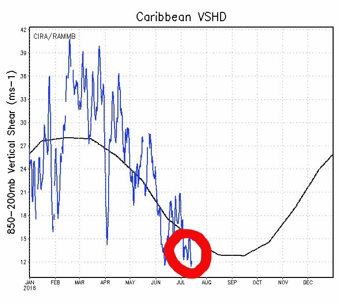
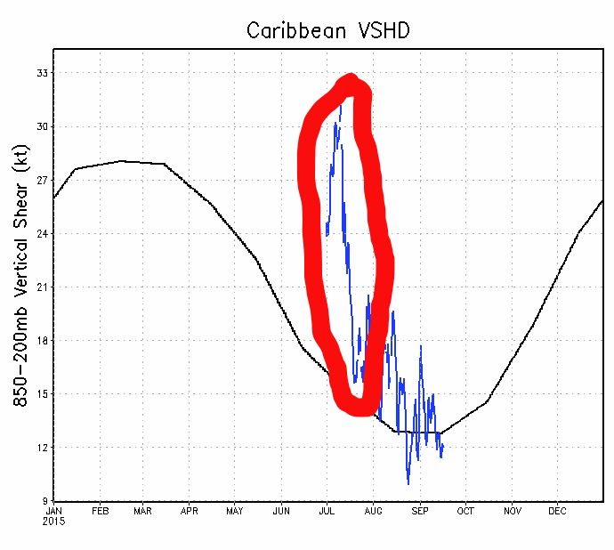
Update on windshear over the Caribbean, graph below continues to suggest that it is below average, compared to last July when it stayed above average the whole month setting records. So clearly El Nino will not be a factor this year as ENSO gone cool neutral and the atmosphere has reacted to it.
0 likes
-
Blown Away

- S2K Supporter
- Posts: 10253
- Joined: Wed May 26, 2004 6:17 am
Re: Seasonal Indicators (Beyond Day 16): Instability / SST's / MSLP / Steering / Sal
0 likes
Hurricane Eye Experience: David 79, Irene 99, Frances 04, Jeanne 04, Wilma 05… Hurricane Brush Experience: Andrew 92, Erin 95, Floyd 99, Matthew 16, Irma 17, Ian 22, Nicole 22…
Re: Seasonal Indicators (Beyond Day 16): Instability / SST's / MSLP / Steering / Sal
Blown Away wrote::uarrow:
Here you go, they have 2000-2013 but you may find 2014's saved images in old threads here at Storm2K, just like I found the 2015 image I posted.
0 likes
Re: Seasonal Indicators (Beyond Day 16): Instability / SST's / MSLP / Steering / Sal
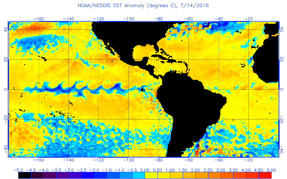
Today's SSTs' anomoly update from NOAA.
0 likes
-
srainhoutx

- S2K Supporter
- Posts: 6919
- Age: 68
- Joined: Sun Jan 14, 2007 11:34 am
- Location: Haywood County, NC
- Contact:
Re: Seasonal Indicators (Beyond Day 16): Instability / SST's / MSLP / Steering / Sal
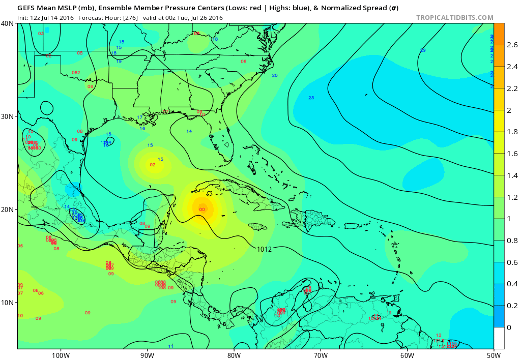
The 12Z GEFS Ensemble Members are beginning to suggest the potential for TC Genesis later in July in the NW Caribbean Sea.
2 likes
Carla/Alicia/Jerry(In The Eye)/Michelle/Charley/Ivan/Dennis/Katrina/Rita/Wilma/Ike/Harvey
Member: National Weather Association
Wx Infinity Forums
http://wxinfinity.com/index.php
Facebook.com/WeatherInfinity
Twitter @WeatherInfinity
Member: National Weather Association
Wx Infinity Forums
http://wxinfinity.com/index.php
Facebook.com/WeatherInfinity
Twitter @WeatherInfinity
-
weathaguyry

- Category 5
- Posts: 1273
- Age: 22
- Joined: Wed Jun 15, 2016 5:16 am
- Location: Long Island, NY
Re: Seasonal Indicators (Beyond Day 16): Instability / SST's / MSLP / Steering / Sal
Well this could really be something to watch, as the ocean is extremely warm in this area

2 likes
My posts are only my opinions and NOT official forecasts. For official forecasts, consult the National Hurricane Center or the National Weather Service.
Irene 11', Sandy 12', Fay 20’, Isaias 20’, Elsa 21’, Henri 21’, Ida 21’
Irene 11', Sandy 12', Fay 20’, Isaias 20’, Elsa 21’, Henri 21’, Ida 21’
-
Yellow Evan

- Professional-Met

- Posts: 16232
- Age: 27
- Joined: Fri Jul 15, 2011 12:48 pm
- Location: Henderson, Nevada/Honolulu, HI
- Contact:
Re: Seasonal Indicators (Beyond Day 16): Instability / SST's / MSLP / Steering / Sal
1 likes