2016 Global Model Runs Discussion (Out to Day 16)

This is the general tropical discussion area. Anyone can take their shot at predicting a storms path.

Moderator: S2k Moderators

Forum rules

The posts in this forum are NOT official forecasts and should not be used as such. They are just the opinion of the poster and may or may not be backed by sound meteorological data. They are NOT endorsed by any professional institution or STORM2K. For official information, please refer to products from the National Hurricane Center and National Weather Service.

Help Support Storm2K
Message
Author
User avatar
TheAustinMan
Category 5
Category 5
Posts: 1047
Age: 25
Joined: Mon Jul 08, 2013 4:26 pm
Location: United States
Contact:

Re: 2016 Global Model Runs Discussion (Out to Day 16)

#801 Postby TheAustinMan » Fri Jul 15, 2016 2:31 pm

@RL3AO I love the mid-level RH product... it's probably one of the best tools for sniffing out tropical waves as they track across the tropics (speaking of waves, pouch tracking by the Navy's Dept. of Meteorology begins July 18, and you can read more about it at http://www.met.nps.edu/~mtmontgo/storms2016-atlantic.html).

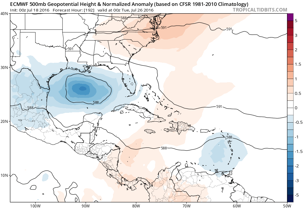
Although tropical development isn't really conclusive within the next two weeks, there are two tropical waves of interest in the Atlantic tropics that might have some, albeit minor, potential for developing. The first is a tropical wave currently over the Lesser Antilles. The models have that particular wave tracking westward into Nicaragua by about July 18-19, though a fragment of the moisture may track further north and may poke its head into the Bay of Campeche around July 21 while the rest of the wave may contribute to a possible EPac tropical cyclone. That said, the BoC fragment will probably stick around Central America without developing. The atmospheric conditions are there, but the geographical ones aren't.

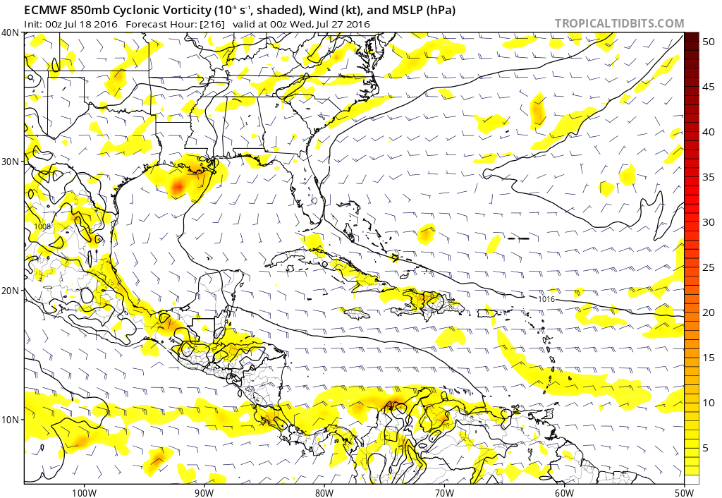
The other disturbance of note is the tropical wave coming off of Africa right now. Although it looks fairly decent on entry into the Atlantic, given the strong presence of the Saharan Air Layer, it'll probably end up being a sacrificial wave to help slowly moisten up the environment. However, the GFS does have it bringing some gusty 25-30kt winds to the Leeward Islands next week. Looking at the RH, it appears possible (given the GFS solution) that the wave might cause some mischief in the Bay of Campeche/Western Gulf of Mexico later down the road (in around two weeks) but that is way too far in the future to be something of concern, at least for now.


The posts in this forum are NOT official forecasts and should not be used as such. They are just the opinion of the poster and may or may not be backed by sound meteorological data. They are NOT endorsed by any professional institution or STORM2K. For official information, please refer to products from the NHC and NWS.
3 likes   
ImageImageImage
Treat my opinions with a grain of salt. For official information see your local weather service.

stormwise

Re: 2016 Global Model Runs Discussion (Out to Day 16)

#802 Postby stormwise » Sat Jul 16, 2016 2:50 am

Little weak closed off disturbance on the monsoon trough out there now.

https://s32.postimg.org/b79fwtjh1/WMBds26.png
1 likes   

User avatar
Hammy
Category 5
Category 5
Posts: 5849
Age: 41
Joined: Fri May 25, 2012 5:25 pm
Contact:

Re: 2016 Global Model Runs Discussion (Out to Day 16)

#803 Postby Hammy » Sat Jul 16, 2016 2:06 pm

Euro is showing a large amount of weak vorticity extending pretty far north at day 10--could this indicate the moisture/instability being pulled north off the ITCZ to pave way for stronger waves and possible development?
1 likes   
The above post is not official and should not be used as such. It is the opinion of the poster and may or may not be backed by sound meteorological data. It is not endorsed by any professional institution or storm2k.org. For official information, please refer to the NHC and NWS products.

User avatar
cycloneye
Admin
Admin
Posts: 145351
Age: 68
Joined: Thu Oct 10, 2002 10:54 am
Location: San Juan, Puerto Rico

Re: 2016 Global Model Runs Discussion (Out to Day 16)

#804 Postby cycloneye » Sun Jul 17, 2016 9:51 am

Healthy waves rolling in Africa on long range and as someone mentioned in another thread,the African wave train will be robust in the coming weeks as the MJO signal is enhancing them.

Image
1 likes   
Visit the Caribbean-Central America Weather Thread where you can find at first post web cams,radars
and observations from Caribbean basin members Click Here

ninel conde

Re: 2016 Global Model Runs Discussion (Out to Day 16)

#805 Postby ninel conde » Sun Jul 17, 2016 11:59 am

Image

I look for the east pac to remain active and the atlantic dead for some time. Pressures are quite low in the east pac. Lots of fertile green, none in the atlantic tropics. High remains perfectly positioned for tons of cane killing atlantic dust.
2 likes   

User avatar
blp
Category 5
Category 5
Posts: 2840
Age: 46
Joined: Thu Sep 09, 2004 7:51 pm
Location: Miami, FL
Contact:

Re: 2016 Global Model Runs Discussion (Out to Day 16)

#806 Postby blp » Sun Jul 17, 2016 1:49 pm

0 likes   
The following post is NOT an official forecast and should not be used as such. It is just the opinion of the poster and may or may not be backed by sound meteorological data. It is NOT endorsed by any professional institution including storm2k.org For Official Information please refer to the NHC and NWS products.

User avatar
Yellow Evan
Professional-Met
Professional-Met
Posts: 16143
Age: 27
Joined: Fri Jul 15, 2011 12:48 pm
Location: Henderson, Nevada/Honolulu, HI
Contact:

Re: 2016 Global Model Runs Discussion (Out to Day 16)

#807 Postby Yellow Evan » Sun Jul 17, 2016 1:50 pm

:uarrow: Just 1 ensemble member though.
1 likes   

User avatar
tarheelprogrammer
S2K Supporter
S2K Supporter
Posts: 1793
Joined: Mon Mar 28, 2016 9:25 pm
Location: Raleigh, NC area (Garner, NC)

Re: 2016 Global Model Runs Discussion (Out to Day 16)

#808 Postby tarheelprogrammer » Sun Jul 17, 2016 1:50 pm

0 likes   
My posts are not official forecasts. They are just my opinion and may or may not be backed by sound meteorological data. They are NOT endorsed by any professional institution or storm2k.org. For official information, please refer to the NHC and NWS products.

User avatar
Hammy
Category 5
Category 5
Posts: 5849
Age: 41
Joined: Fri May 25, 2012 5:25 pm
Contact:

Re: 2016 Global Model Runs Discussion (Out to Day 16)

#809 Postby Hammy » Sun Jul 17, 2016 2:11 pm


Seems less than the last few, I think there were large areas of white on previous ones.

On the note of the GFS being void of anything of note, I wouldn't really look to them at the moment for hope of later storms--all recieved upgrades this year and have been pushed to the conservative side of the forecasting spectrum. They seem to behave differently in the Atlantic for some reason, and that said, we aren't having the phantom storms any longer which is making the quiet period seem longer than it may be (but at the same time things aren't being "pushed back" either, like the last few seasons), and of the storms we've had so far only the Canadian model correctly showed anything forming more than three days out, and even then, it was only about a week or so that it showed any of them. Should something form around say August 5, I wouldn't expect the models to actually sniff it out until July 29-30. Until then the models will be void of anything.

(And personally I'm betting on >Aug 15 before we get another storm.)

Edit: one sign of change is the Euro having the ITCZ more defined, and further north, in the Atlantic while bringing the waves off Africa a tad further south.
Image
0 likes   
The above post is not official and should not be used as such. It is the opinion of the poster and may or may not be backed by sound meteorological data. It is not endorsed by any professional institution or storm2k.org. For official information, please refer to the NHC and NWS products.

User avatar
WPBWeather
S2K Supporter
S2K Supporter
Posts: 535
Age: 67
Joined: Thu Jul 18, 2013 12:33 pm

Re: 2016 Global Model Runs Discussion (Out to Day 16)

#810 Postby WPBWeather » Sun Jul 17, 2016 4:03 pm

ninel conde wrote:Image

I look for the east pac to remain active and the atlantic dead for some time. Pressures are quite low in the east pac. Lots of fertile green, none in the atlantic tropics. High remains perfectly positioned for tons of cane killing atlantic dust.


Not true. Dust levels are declining as normal near end of July. Rain is increasing in Africa (we had this discussion last week, remember?) You'll have to come up with something other than "killer SAL."
0 likes   

User avatar
Hammy
Category 5
Category 5
Posts: 5849
Age: 41
Joined: Fri May 25, 2012 5:25 pm
Contact:

Re: 2016 Global Model Runs Discussion (Out to Day 16)

#811 Postby Hammy » Sun Jul 17, 2016 4:34 pm

WPBWeather wrote:
ninel conde wrote:I look for the east pac to remain active and the atlantic dead for some time. Pressures are quite low in the east pac. Lots of fertile green, none in the atlantic tropics. High remains perfectly positioned for tons of cane killing atlantic dust.


Not true. Dust levels are declining as normal near end of July. Rain is increasing in Africa (we had this discussion last week, remember?) You'll have to come up with something other than "killer SAL."


My question is, are the waves/ITCZ in Africa too far north and is this contributing to the problem, or is the location normal and still waiting for the monsoon trough that's present there to moisten? I noticed last night but don't have model/surface data to know if it's normally at 18-20N.

And to ninel: The models are indicating the Epac slowing down over the coming weeks. No longer are we getting a storm forming every 3-4 days and only the current system over Central America is shown to form there now.

Edit: Latest GFS shows no storms in either basin through August 2, but shows a large deep monsoonal flow out of the west off of Africa, something I haven't seen in quite a few years.

Image

And again some previous seasons come to mind.

Image
Image
1 likes   
The above post is not official and should not be used as such. It is the opinion of the poster and may or may not be backed by sound meteorological data. It is not endorsed by any professional institution or storm2k.org. For official information, please refer to the NHC and NWS products.

ninel conde

Re: 2016 Global Model Runs Discussion (Out to Day 16)

#812 Postby ninel conde » Mon Jul 18, 2016 7:50 am

Image

for the first time pressures relaxing in the atlantic tropics and the high is not as well placed to surge out dust. trend or just temporary?
0 likes   

User avatar
srainhoutx
S2K Supporter
S2K Supporter
Posts: 6919
Age: 67
Joined: Sun Jan 14, 2007 11:34 am
Location: Haywood County, NC
Contact:

Re: 2016 Global Model Runs Discussion (Out to Day 16)

#813 Postby srainhoutx » Mon Jul 18, 2016 8:21 am

Interestingly the ECMWF for the past couple of cycles is suggesting a fairly decent weakness with lowering pressures rounding the Eastern flank of the Upper Ridge and moving West across the Gulf around the 26th to 28th of July. The GFS does show this Easterly wave, but is not as aggressive as the ECMWF...but it does merit monitoring as the general Hemispheric Pattern may favor such a feature in the longer range.

Image

Image
0 likes   
Carla/Alicia/Jerry(In The Eye)/Michelle/Charley/Ivan/Dennis/Katrina/Rita/Wilma/Ike/Harvey

Member: National Weather Association
Wx Infinity Forums
http://wxinfinity.com/index.php

Facebook.com/WeatherInfinity
Twitter @WeatherInfinity

Alyono
Professional-Met
Professional-Met
Posts: 6961
Joined: Fri Apr 26, 2013 3:52 pm
Location: Texas Coast

Re: 2016 Global Model Runs Discussion (Out to Day 16)

#814 Postby Alyono » Mon Jul 18, 2016 8:22 am

latest MU keeps the EPAC very active through the next 16 days
0 likes   

Dean4Storms
S2K Supporter
S2K Supporter
Posts: 6358
Age: 62
Joined: Sun Aug 31, 2003 1:01 pm
Location: Miramar Bch. FL

Re: 2016 Global Model Runs Discussion (Out to Day 16)

#815 Postby Dean4Storms » Mon Jul 18, 2016 8:48 am

They don't refer to the "Cape Verde Season" for nothing, on average the TW train doesn't usually become favorable for long tracking robust TW's going on to develop into TC's out in the MDR until early to mid August. Yes, there have been years where that happened sooner and those years were generally well above normal in TC numbers in the Atlantic basin and especially the MDR, I don't think anybody is expecting an above normal season on the Atlantic side. I do believe we'll begin to see relaxing pressures across the MDR and north Africa come early to mid August resulting in more robust TW's with some development out there considering everything and by that point our biggest concern will not be development but the overall pressure pattern over Eastern NA extending out into the Atlantic! The MJO will become a big factor for waves once they reach the Western Atlantic and Carib. Sea!
1 likes   

User avatar
Siker
Category 4
Category 4
Posts: 904
Age: 28
Joined: Thu Oct 25, 2012 7:36 pm
Location: Miami, FL

Re: 2016 Global Model Runs Discussion (Out to Day 16)

#816 Postby Siker » Mon Jul 18, 2016 11:39 am

Strong wave emerging off of Africa in 9 days on the GFS and Euro (the one that was being picked up on by a few GEFS members).
0 likes   

User avatar
gatorcane
S2K Supporter
S2K Supporter
Posts: 23691
Age: 47
Joined: Sun Mar 13, 2005 3:54 pm
Location: Boca Raton, FL

Re: 2016 Global Model Runs Discussion (Out to Day 16)

#817 Postby gatorcane » Mon Jul 18, 2016 11:47 am

Finally looks like something of significance on the 12Z GFS rolling off Africa by day 10

Image
2 likes   

User avatar
tarheelprogrammer
S2K Supporter
S2K Supporter
Posts: 1793
Joined: Mon Mar 28, 2016 9:25 pm
Location: Raleigh, NC area (Garner, NC)

Re: 2016 Global Model Runs Discussion (Out to Day 16)

#818 Postby tarheelprogrammer » Mon Jul 18, 2016 11:48 am

gatorcane wrote:Finally looks like something of significance on the 12Z GFS rolling off Africa by day 10


Very strong wave. TS almost right off the coast of Africa. Can it make it across the Atlantic? Or is it a fish storm? 8-)
0 likes   
My posts are not official forecasts. They are just my opinion and may or may not be backed by sound meteorological data. They are NOT endorsed by any professional institution or storm2k.org. For official information, please refer to the NHC and NWS products.

RL3AO
Moderator-Pro Met
Moderator-Pro Met
Posts: 16308
Joined: Thu Jun 14, 2007 10:03 pm
Location: NC

Re: 2016 Global Model Runs Discussion (Out to Day 16)

#819 Postby RL3AO » Mon Jul 18, 2016 11:51 am

IMO anything that comes off the coast like that will weaken/open up over the eastern Atlantic. It's not very hospitable out there. A strong wave like that would move west and possibly try to develop near islands/Bahamas.
0 likes   

User avatar
tarheelprogrammer
S2K Supporter
S2K Supporter
Posts: 1793
Joined: Mon Mar 28, 2016 9:25 pm
Location: Raleigh, NC area (Garner, NC)

Re: 2016 Global Model Runs Discussion (Out to Day 16)

#820 Postby tarheelprogrammer » Mon Jul 18, 2016 11:53 am

RL3AO wrote:IMO anything that comes off the coast like that will weaken/open up over the eastern Atlantic. It's not very hospitable out there. A strong wave like that would move west and possibly try to develop near islands/Bahamas.


It has the storm weaken over the Atlantic. Possibly dying out/doing nothing. Just too much stability and dry air for that matter.
0 likes   
My posts are not official forecasts. They are just my opinion and may or may not be backed by sound meteorological data. They are NOT endorsed by any professional institution or storm2k.org. For official information, please refer to the NHC and NWS products.


Return to “Talkin' Tropics”

Who is online

Users browsing this forum: Lizzytiz1, Pas_Bon, TomballEd and 47 guests