XUS64 KHGX 221133
AFDHGX
Area Forecast Discussion
National Weather Service Houston/Galveston TX
633 AM CDT FRI JUL 22 2016
.AVIATION...
VFR conditions are expected. Isolated showers may affect the
immediate coastal site /KGLS/ before 15Z. The current water vapor
and the models to hint at the possibility for isolated showers
this afternoon near and east of KIAH, KCXO, and KUTS.
40
.PREV DISCUSSION... /ISSUED 415 AM CDT FRI JUL 22 2016/
DISCUSSION...
At 3 AM, a weak area of high pressure was located over extreme SW
LA. At 850 mb, high pressure was located N MS with a patch of
deeper moisture undercutting the ridge over S LA. At 300 mb, a
strong upper level high pressure system was centered over NW TX
and this feature is sprawling much of the southern U.S. 850 mb
temperatures remain very warm and am expecting max temps today to
be similar to yesterday. Forecast soundings show PW values
approaching 2.00 inches with little capping noted after 21z.
Convective temperatures are between 93-96 degrees so not expecting
much in the way of shra/tsra until mid/late afternoon. Water
vapor imagery shows a disturbance over LA/E MS and this feature
should arrive in SE TX around 18z. Although guidance does not
suggest much precipitation coverage today, am a littler nervous
that this disturbance could bring a bit more activity to at least
the eastern half of the CWA.
Moisture levels continue to deepen on Saturday with PW values
again exceeding 2.00 inches by 21z. Convective temperatures cool
into the lower 90s but still some weak capping noted in the
750-700 mb layer. The upper level ridge plaguing the region will
begin to shift west so feel the lower heights coupled with the
lower convective temps and moisture should foster slightly higher
rain chances on Saturday.
Rain chances increase further on Sunday as PW values peak between
2.20 and 2.30 inches. Forecast soundings look very favorable with
a deeper saturated layer between 900-750 mb. Fcst soundings also
show an inverted V signature so some of the stronger storms could
produce some gusty winds. 500 mb heights lower to 591 DM and 850
mb temps continue to lower. Convective temps are around 90 so
think potential for rain on Sunday is pretty high. Storm motion on
Sunday also looks to be less than 10 knots so there could be some
pockets of locally heavy rain.
Rain chances should remain high for much of the week ahead as the
upper ridge remains to the north and west of the region. An
inverted upper trough will migrate west across the Gulf of Mexico
Tues-Thurs and this feature will keep showers and storms in the
forecast. With the added cloud cover and precipitation,
temperatures will trend to near normal or even slightly below
normal by the middle of next week.
MARINE...
Looks like a typical summer time pattern. Could see some increase in
showers or thunderstorms starting this weekend into the first half
of the new week, especially during the morning and early afternoon
time period each day.
40
FIRE...
The airmass should mix out during the afternoon today and Saturday.
This should allow for minimum Relative Humidity values to dip into
the 35 to 40 percent range generally west of the US-59 corridor. The
latest models are showing that an increase in the coverage of
showers and thunderstorms will be possible by Sunday and Monday.
40
$$
&&
.PRELIMINARY POINT TEMPS/POPS...
College Station (CLL) 99 77 98 77 97 / 10 10 20 10 30
Houston (IAH) 98 79 97 79 96 / 20 10 30 10 50
Galveston (GLS) 93 82 92 82 91 / 20 20 20 20 40
&&
.HGX WATCHES/WARNINGS/ADVISORIES...
TX...NONE.
GM...NONE.
&&
$$
Discussion...43
Aviation/Marine...40
Texas Summer 2016
Moderator: S2k Moderators
Forum rules

The posts in this forum are NOT official forecast and should not be used as such. They are just the opinion of the poster and may or may not be backed by sound meteorological data. They are NOT endorsed by any professional institution or STORM2K.
-
Tireman4

- S2K Supporter

- Posts: 5903
- Age: 60
- Joined: Fri Jun 30, 2006 1:08 pm
- Location: Humble, Texas
- Contact:
Re: Texas Summer 2016
0 likes
-
weatherdude1108
- Category 5

- Posts: 4228
- Joined: Tue Dec 13, 2011 1:04 pm
- Location: Northwest Austin/Cedar Park, TX
Re: Texas Summer 2016
We complain about the dryness now in Central Texas.
This story was posted five years ago (2011). What an awful year in history.
Drought impacting Central Texas wildlife
https://youtu.be/fUxI3usl47Y
This story was posted five years ago (2011). What an awful year in history.
Drought impacting Central Texas wildlife
https://youtu.be/fUxI3usl47Y
0 likes
The preceding post is NOT an official forecast, and should not be used as such. It is only the opinion of the poster and may or may not be backed by sound meteorological data. It is NOT endorsed by any professional institution including storm2k.org. For Official Information please refer to the NHC and NWS products.

Re: Texas Summer 2016
Oh so horrible memories. I was going through Eric Webb's improvement on the MEI. You can see why 2011 baked the way it did. The amazing thing was 2009 and 2010 were not that dry. How quickly things spiraled was an enigma on its own. There are two parts to ENSO the ocean and the atmosphere, while 2010-2011 Nina wasn't the strongest on record ocean wise, by the MEI (measurement in the atmospheric response) it is #1 on the reccord. The Nina pattern came quickly and stuck faster than other events more closely related to 1998 and 1999. You went from Hermine floods some months earlier then was decimated by one if the worse singular drought years.
0 likes
The above post and any post by Ntxw is NOT an official forecast and should not be used as such. It is just the opinion of the poster and may or may not be backed by sound meteorological data. It is NOT endorsed by any professional institution including Storm2k. For official information, please refer to NWS products.
Help support Storm2K!
-
Portastorm

- Storm2k Moderator

- Posts: 9955
- Age: 63
- Joined: Fri Jul 11, 2003 9:16 am
- Location: Round Rock, TX
- Contact:
Re: Texas Summer 2016
Austin has now recorded high temperatures at or above normal for 43 consecutive days. No sign of that abating either. While this isn't 2011, it still sucks.
0 likes
Any forecasts under my name are to be taken with a grain of salt. Get your best forecasts from the National Weather Service and National Hurricane Center.
-
Tireman4
- S2K Supporter
- Posts: 5903
- Age: 60
- Joined: Fri Jun 30, 2006 1:08 pm
- Location: Humble, Texas
- Contact:
Re: Texas Summer 2016
Portastorm wrote:Austin has now recorded high temperatures at or above normal for 43 consecutive days. No sign of that abating either. While this isn't 2011, it still sucks.
Agreed Porta. I hate it. Oh..well..you know..it could be the Indians and Astros for the right to go to the World Series..
0 likes
-
Tireman4
- S2K Supporter
- Posts: 5903
- Age: 60
- Joined: Fri Jun 30, 2006 1:08 pm
- Location: Humble, Texas
- Contact:
Re: Texas Summer 2016
Ntxw wrote:Oh so horrible memories. I was going through Eric Webb's improvement on the MEI. You can see why 2011 baked the way it did. The amazing thing was 2009 and 2010 were not that dry. How quickly things spiraled was an enigma on its own. There are two parts to ENSO the ocean and the atmosphere, while 2010-2011 Nina wasn't the strongest on record ocean wise, by the MEI (measurement in the atmospheric response) it is #1 on the reccord. The Nina pattern came quickly and stuck faster than other events more closely related to 1998 and 1999. You went from Hermine floods some months earlier then was decimated by one if the worse singular drought years.
Oh man..not 2011 again..ughh..LOL
0 likes
Re: Texas Summer 2016
94F at DFW noontime. Winds are out of the southwest today, will be close
In 2011 by 10am many days were already at 100F
In 2011 by 10am many days were already at 100F
0 likes
The above post and any post by Ntxw is NOT an official forecast and should not be used as such. It is just the opinion of the poster and may or may not be backed by sound meteorological data. It is NOT endorsed by any professional institution including Storm2k. For official information, please refer to NWS products.
Help support Storm2K!
Help support Storm2K!
-
weatherdude1108
- Category 5
- Posts: 4228
- Joined: Tue Dec 13, 2011 1:04 pm
- Location: Northwest Austin/Cedar Park, TX
Re: Texas Summer 2016
Well, this EWX discussion is slightly more encouraging for early next week. It's another "wait and see" game. Keep that death ridge out west!
Area Forecast Discussion
National Weather Service Austin/San Antonio TX
314 PM CDT FRI JUL 22 2016
.SHORT TERM (Tonight through Saturday Night)...
Similar to yesterday afternoon, isolated showers are currently
developing near the middle Texas coast. This activity is expected
to weaken while moving inland, so we`ll keep the forecast dry for
south central Texas through the remainder of today. Otherwise,
another day of above normal temperatures is taking shape with
plenty of mid-afternoon readings already in the lower 90s to near
100 degrees. We do expect a few afternoon heat index values near
105 degrees today, especially along and east of the I-35
corridor. A slight uptick in low-level moisture will lead to
afternoon convection near the coastal plains on Saturday. We will
carry a 20% chance for showers and thunderstorms for areas
generally east of a Pleasanton to Giddings line to account for
any isolated convection. The slightly higher moisture content will
also lead to an increase in afternoon heat index values along the
coastal plains, with a few locations peaking between 105-108
degrees.
&&
.LONG TERM (Sunday through Friday)...
[b]The persistent area of mid and upper level high pressure over the
Great Plains will begin to re-center itself over the western U.S.
by the middle of the upcoming work week. This pattern will allow
an upper trough currently off the southeast U.S. coast to
retrograde into the Gulf of Mexico and eventually south Texas
toward the early and middle of this week. There are some timing
difference noted between the operational GFS and ECMWF, with the
GFS being slightly faster and a little stronger with this feature.
Given this pattern, we expect a slight increase in rain chances
across south central Texas through the early and middle portion of
next week. Rain chances on Sunday will initially be confined to
the coastal plains, but will spread westward into the I-35
corridor on Monday. As deep layer moisture increases and the
influence of the upper ridge weakens, we will push rain chances
westward to the Rio Grande on Tuesday. The medium range models
continue to show the remnants of the upper trough or perhaps a col
developing across the region late next week. This will likely keep
any rain chances limited to the coastal plains where the afternoon
sea breeze could aid in developing isolated convection.
Temperatures should also ease back closer to climatological
normals for the latter half of the forecast period.
[/b]
0 likes
The preceding post is NOT an official forecast, and should not be used as such. It is only the opinion of the poster and may or may not be backed by sound meteorological data. It is NOT endorsed by any professional institution including storm2k.org. For Official Information please refer to the NHC and NWS products.
-
Brent
- S2K Supporter
- Posts: 38738
- Age: 37
- Joined: Sun May 16, 2004 10:30 pm
- Location: Tulsa Oklahoma
- Contact:
Re: Texas Summer 2016
99 at DFW at 4pm... if it's going to happen today, it will be soon...
Edit: Looks like 99 it is... we got one more chance or it could be awhile.
Edit: Looks like 99 it is... we got one more chance or it could be awhile.
Last edited by Brent on Fri Jul 22, 2016 4:38 pm, edited 1 time in total.
0 likes
#neversummer
-
weatherdude1108
- Category 5
- Posts: 4228
- Joined: Tue Dec 13, 2011 1:04 pm
- Location: Northwest Austin/Cedar Park, TX
Re: Texas Summer 2016
I could have just pushed "rewind" to yesterday. 
I have to smile because there's nothing better to do. I think I see rain. Oh wait, just a mirage.lol
Current conditions at
Austin City, Austin Camp Mabry (KATT)
Lat: 30.32°NLon: 97.77°WElev: 656ft.

Fair
100°F
38°C
Humidity 33%
Wind Speed Vrbl 7 mph
Barometer 30.03 in (1015.2 mb)
Dewpoint 66°F (19°C)
Visibility 10.00 mi
Heat Index 104°F (40°C)
Last update 22 Jul 3:51 pm CDT
I have to smile because there's nothing better to do. I think I see rain. Oh wait, just a mirage.lol
Current conditions at
Austin City, Austin Camp Mabry (KATT)
Lat: 30.32°NLon: 97.77°WElev: 656ft.
Fair
100°F
38°C
Humidity 33%
Wind Speed Vrbl 7 mph
Barometer 30.03 in (1015.2 mb)
Dewpoint 66°F (19°C)
Visibility 10.00 mi
Heat Index 104°F (40°C)
Last update 22 Jul 3:51 pm CDT
1 likes
The preceding post is NOT an official forecast, and should not be used as such. It is only the opinion of the poster and may or may not be backed by sound meteorological data. It is NOT endorsed by any professional institution including storm2k.org. For Official Information please refer to the NHC and NWS products.
-
aggiecutter
- Category 5
- Posts: 1755
- Joined: Thu Oct 14, 2004 9:22 pm
- Location: Texarkana
Re: Texas Summer 2016
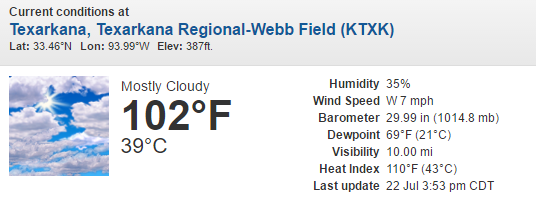
I know Weatherman57 is jealous of my 110 heat index. I think I'm fixin to go outside and jog 10 miles. Hopefully, I'll break a sweat.

0 likes
-
aggiecutter
- Category 5
- Posts: 1755
- Joined: Thu Oct 14, 2004 9:22 pm
- Location: Texarkana
Re: Texas Summer 2016
Unfortunately, it looks like this heatwave is going to be short lived, and I was just beginning to enjoy it.

0 likes
-
South Texas Storms

- Professional-Met

- Posts: 4256
- Joined: Thu Jun 24, 2010 12:28 am
- Location: Houston, TX
Re: Texas Summer 2016
Brent wrote:99 at DFW at 4pm... if it's going to happen today, it will be soon...
Edit: Looks like 99 it is... we got one more chance or it could be awhile.
Nope, DFW hit 100 around 5 pm according to the NWS Climo page.
0 likes
Re: Texas Summer 2016
Yes DFW hit 100. 1906/1973 stands alone
0 likes
The above post and any post by Ntxw is NOT an official forecast and should not be used as such. It is just the opinion of the poster and may or may not be backed by sound meteorological data. It is NOT endorsed by any professional institution including Storm2k. For official information, please refer to NWS products.
Help support Storm2K!
Help support Storm2K!
-
Brent
- S2K Supporter
- Posts: 38738
- Age: 37
- Joined: Sun May 16, 2004 10:30 pm
- Location: Tulsa Oklahoma
- Contact:
Re: Texas Summer 2016
Ntxw wrote:Yes DFW hit 100. 1906/1973 stands alone
Darn.
Oh well, it was inevitable anyway... I don't really think 1906/1973 would repeat as much as it'd be nice.
0 likes
#neversummer
Re: Texas Summer 2016
Brent wrote:Ntxw wrote:Yes DFW hit 100. 1906/1973 stands alone
Darn.
Oh well, it was inevitable anyway... I don't really think 1906/1973 would repeat as much as it'd be nice.
Yeah I was rooting for it, oh well. We likely won't see too many 100 days anyway the rest of the way a few more realistic chances then it's iffy after that. We're more likely to see a sub zero reading on a given year than no 100s when looking at historical statistics. Pretty rare.
0 likes
The above post and any post by Ntxw is NOT an official forecast and should not be used as such. It is just the opinion of the poster and may or may not be backed by sound meteorological data. It is NOT endorsed by any professional institution including Storm2k. For official information, please refer to NWS products.
Help support Storm2K!
Help support Storm2K!
-
A.V.
Re: Texas Summer 2016
I will never understand why convection that easily happens in Louisiana just dies the instant is crosses the state line into Texas. Things like this make me feel that there is a supernatural component to blame in regards to summer dry spells in Texas.
0 likes
Re: Texas Summer 2016
Just got back from Acambaro/Mexico City where I had a two week stretch where it rained daily except one day. Temperatures in the mountains around Acambaro and in Central Mexico City were quite cool with 50's in the morning and 70's during the afternoon. Came back today to a blast of heat and a 100 degree day. Bring on autumn.
0 likes
-
BrokenGlassRepublicn
- Category 1

- Posts: 483
- Joined: Sun Nov 20, 2011 8:07 pm
- Location: Richardson, Texas
Re: Texas Summer 2016
I'm nothing more than an observer, but I would assume that in LA, your southerly and southwesterly flows are off the gulf, whereas in Texas, those same flows are off the high desert of Mexico. At least that's the way I've heard the "capping inversion" explained in the past...nothing more than a very dry mid-level atmosphere that simply requires too much lift and moisture.A.V. wrote:I will never understand why convection that easily happens in Louisiana just dies the instant is crosses the state line into Texas. Things like this make me feel that there is a supernatural component to blame in regards to summer dry spells in Texas.
0 likes
Return to “USA & Caribbean Weather”
Who is online
Users browsing this forum: Brent, Stratton23 and 57 guests