2016 Global Model Runs Discussion (Out to Day 16)
Moderator: S2k Moderators
Forum rules

The posts in this forum are NOT official forecasts and should not be used as such. They are just the opinion of the poster and may or may not be backed by sound meteorological data. They are NOT endorsed by any professional institution or STORM2K. For official information, please refer to products from the National Hurricane Center and National Weather Service.
-
tolakram
- Admin

- Posts: 20185
- Age: 62
- Joined: Sun Aug 27, 2006 8:23 pm
- Location: Florence, KY (name is Mark)
Re: 2016 Global Model Runs Discussion (Out to Day 16)
Link to thread for this wave: viewtopic.php?p=2514408#p2514408
0 likes
M a r k
- - - - -
Join us in chat: Storm2K Chatroom Invite. Android and IOS apps also available.
The posts in this forum are NOT official forecasts and should not be used as such. Posts are NOT endorsed by any professional institution or STORM2K.org. For official information and forecasts, please refer to NHC and NWS products.
Re: 2016 Global Model Runs Discussion (Out to Day 16)
looking at the simulated IR from the MU, there is very strong shear in the MDR that will develop in the coming days
0 likes
-
TheStormExpert
Re: 2016 Global Model Runs Discussion (Out to Day 16)
Long range 18z GFS at it again with development in the Tropical Atlantic.

0 likes
-
TheStormExpert
Re: 2016 Global Model Runs Discussion (Out to Day 16)
Alyono wrote:looking at the simulated IR from the MU, there is very strong shear in the MDR that will develop in the coming days
18z GFS does show a few windows of increasing shear with pockets of lighter shear.


0 likes
-
TheStormExpert
Re: 2016 Global Model Runs Discussion (Out to Day 16)
Joe B. is tweeting about the Atlantic again.
https://twitter.com/bigjoebastardi/status/758078405996720128
https://twitter.com/bigjoebastardi/status/758078405996720128
2 likes
-
cycloneye

- Admin
- Posts: 149387
- Age: 69
- Joined: Thu Oct 10, 2002 10:54 am
- Location: San Juan, Puerto Rico
Re: 2016 Global Model Runs Discussion (Out to Day 16)
2 likes
Visit the Caribbean-Central America Weather Thread where you can find at first post web cams,radars
and observations from Caribbean basin members Click Here
and observations from Caribbean basin members Click Here

Re: 2016 Global Model Runs Discussion (Out to Day 16)
I wouldn't be going by the GFS's wind shear forecast past 72 hrs.
Here is a good example of what it was forecasting for the Caribbean just 7 days ago for 18z today, widespread 20-40 knots of windshear across that area:

Here is the actual windshear analyzes at 18z, no where close as hostile as the GFS was forecasting:
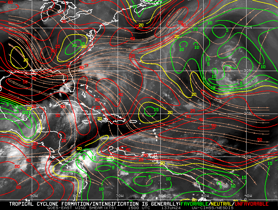
Here is a good example of what it was forecasting for the Caribbean just 7 days ago for 18z today, widespread 20-40 knots of windshear across that area:
Here is the actual windshear analyzes at 18z, no where close as hostile as the GFS was forecasting:
2 likes
-
tolakram
- Admin
- Posts: 20185
- Age: 62
- Joined: Sun Aug 27, 2006 8:23 pm
- Location: Florence, KY (name is Mark)
Re: 2016 Global Model Runs Discussion (Out to Day 16)
0 likes
M a r k
- - - - -
Join us in chat: Storm2K Chatroom Invite. Android and IOS apps also available.
The posts in this forum are NOT official forecasts and should not be used as such. Posts are NOT endorsed by any professional institution or STORM2K.org. For official information and forecasts, please refer to NHC and NWS products.
- - - - -
Join us in chat: Storm2K Chatroom Invite. Android and IOS apps also available.
The posts in this forum are NOT official forecasts and should not be used as such. Posts are NOT endorsed by any professional institution or STORM2K.org. For official information and forecasts, please refer to NHC and NWS products.
Re: 2016 Global Model Runs Discussion (Out to Day 16)
Not surprisingly, CMC has dropped that East Coast storm
0 likes
-
stormwise
Re: 2016 Global Model Runs Discussion (Out to Day 16)
looks close to a TD on the EC at times, but it dies out in the Bahamas. Maybe a fine line between development and no development in the environment?
0 likes


Re: 2016 Global Model Runs Discussion (Out to Day 16)
Alyono wrote:looks close to a TD on the EC at times, but it dies out in the Bahamas. Maybe a fine line between development and no development in the environment?
Could proximity to land also be inhibiting development on this run?
0 likes
The above post is not official and should not be used as such. It is the opinion of the poster and may or may not be backed by sound meteorological data. It is not endorsed by any professional institution or storm2k.org. For official information, please refer to the NHC and NWS products.
-
stormwise
Re: 2016 Global Model Runs Discussion (Out to Day 16)
https://s31.postimg.org/46phtcamz/ecmwf ... atl_21.png
Maybe a rain event with some high surf?
Maybe a rain event with some high surf?
0 likes

-
TheStormExpert
-
USTropics
- Professional-Met

- Posts: 2738
- Joined: Sun Aug 12, 2007 3:45 am
- Location: Florida State University
Re: 2016 Global Model Runs Discussion (Out to Day 16)
HFIP Probability products:
CIRA, Mark DeMaria and Andrea Schumacher, co-leads
Operational NHC wind speed probability model with global model ensemble tracks. Plots are not based on one model, several ensemble models go into the solution: 133 tracks used: GFS (20), CMC (20), EMCWF (50), FNMOC (20), and UKMET (23).
GFDL, Tim Marchok, lead
o Ensemble-based probability storm formation, 2012 08 03 00. Tracker software is run on multiple global model ensembles (the referenced image)
o Ensemble perturbation forecast storm tracks, 2012 08 03 00. (Not shown on hfip.org at this time.)
Participating Ensemble Models:
NCEP (US National Center for Env Prediction) GFS Ensemble
CMC (Canadaian Meteo Centre) Ensemble
FNMOC (Fleet Numerical Meteo & Ocean Center) Ensemble
ECMWF (European Centre) Ensemble
You can find them here btw: http://www.hfip.org/data/?Path=prob
Other products: http://www.hfip.org/products/
Direct link to referenced image: http://www.emc.ncep.noaa.gov/gmb/tpm/emchurr/tcgen/tcgif/genprob.aeperts.2016072700.altg.000_120.png
0 likes
Re: 2016 Global Model Runs Discussion (Out to Day 16)
Hard to believe the GFS which keeps dissipating the tropical wave as it tracks westward towards the Caribbean showing it encountering 40-50 knot SW windshear just east of the Lesser Antilles when windshear has been running below average across the MDR and Caribbean.
0 likes
-
srainhoutx

- S2K Supporter

- Posts: 6919
- Age: 68
- Joined: Sun Jan 14, 2007 11:34 am
- Location: Haywood County, NC
- Contact:
Re: 2016 Global Model Runs Discussion (Out to Day 16)
I would monitor the Western Caribbean in the longer range for any potential TC Genesis. The GEFS Ensembles are beginning to suggest some clustering of the individual members and the area may be rather conducive for potential tropical development in about 10 days or so.
2 likes
Carla/Alicia/Jerry(In The Eye)/Michelle/Charley/Ivan/Dennis/Katrina/Rita/Wilma/Ike/Harvey
Member: National Weather Association
Wx Infinity Forums
http://wxinfinity.com/index.php
Facebook.com/WeatherInfinity
Twitter @WeatherInfinity
Member: National Weather Association
Wx Infinity Forums
http://wxinfinity.com/index.php
Facebook.com/WeatherInfinity
Twitter @WeatherInfinity
-
TheStormExpert
Re: 2016 Global Model Runs Discussion (Out to Day 16)
Extremely long range 12z GFS with another strong TS forming instantly once in exits Africa.


1 likes
-
cycloneye
- Admin
- Posts: 149387
- Age: 69
- Joined: Thu Oct 10, 2002 10:54 am
- Location: San Juan, Puerto Rico
Re: 2016 Global Model Runs Discussion (Out to Day 16)
1 likes
Visit the Caribbean-Central America Weather Thread where you can find at first post web cams,radars
and observations from Caribbean basin members Click Here
and observations from Caribbean basin members Click Here
Who is online
Users browsing this forum: bird, Iceresistance and 105 guests