Tropical Wave (Ex-Invest 96L) Near Hispanola
Moderator: S2k Moderators


Re: ATL: INVEST 96L - Discussion
Wouldn't 96L's moisture envelope help to somewhat protect it form the SAl?
0 likes
The posts or stuff said are NOT an official forecast. Please look to the NHC and NWS for official forecasts and products.
Floyd-1999, Frances-2004, Jeanne-2004, Fay-2008, Beryl-2012, Debby-2012, Colin-2016, Hermine-2016, Julia-2016, Matthew-2016, Irma-2017, Elsa-2021, Idalia-2023, Debby-2024, Helene-2024.
Go Gators! Go Jags!
Floyd-1999, Frances-2004, Jeanne-2004, Fay-2008, Beryl-2012, Debby-2012, Colin-2016, Hermine-2016, Julia-2016, Matthew-2016, Irma-2017, Elsa-2021, Idalia-2023, Debby-2024, Helene-2024.
Go Gators! Go Jags!
Re: ATL: INVEST 96L - Discussion

Winds are meh. Monsoon trough has helped close it off, but probably not to a level of organization to be considered TCG.
0 likes
Re: ATL: INVEST 96L - Discussion
JaxGator wrote:Wouldn't 96L's moisture envelope help to somewhat protect it form the SAl?
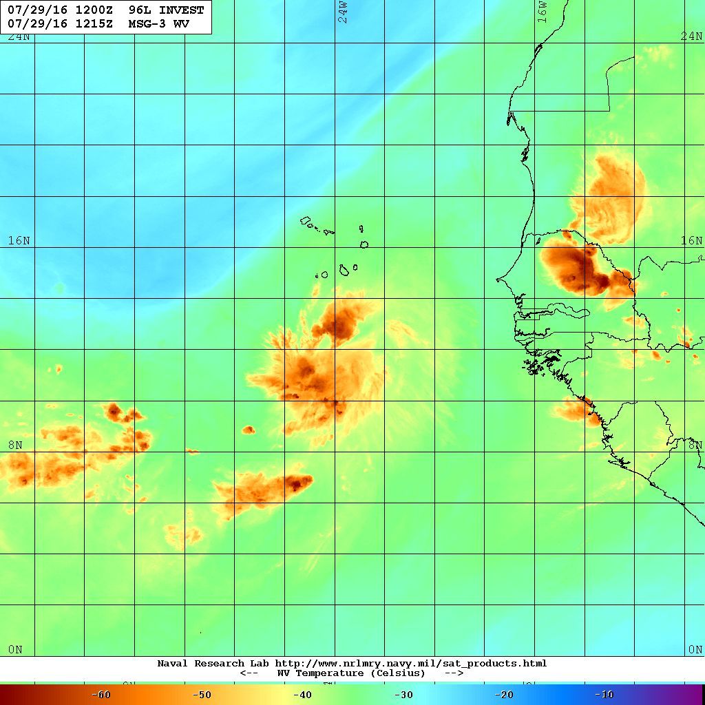
Need to remember that a SAL is not only a dry layer, but its a warm layer. It transposes a very warm/dry layer on top of a tropical boundary layer. This means the atmosphere is very stable/capped in the mid-levels that makes it difficult for any small system to overcome. You also combine this with the sinking air from a suppressed kelvin wave and generally divergent surface flow, it means the central Atlantic will be unfavorable in a few days.
2 likes
-
srainhoutx

- S2K Supporter

- Posts: 6919
- Age: 68
- Joined: Sun Jan 14, 2007 11:34 am
- Location: Haywood County, NC
- Contact:
Re: ATL: INVEST 96L - Discussion
96L does have a decent protective moisture plume and anticyclonic flow aloft. But a suppressed Convectively Coupled Kelvin Wave may limit the 'spark' needed to develop this disturbance.
0 likes
Carla/Alicia/Jerry(In The Eye)/Michelle/Charley/Ivan/Dennis/Katrina/Rita/Wilma/Ike/Harvey
Member: National Weather Association
Wx Infinity Forums
http://wxinfinity.com/index.php
Facebook.com/WeatherInfinity
Twitter @WeatherInfinity
Member: National Weather Association
Wx Infinity Forums
http://wxinfinity.com/index.php
Facebook.com/WeatherInfinity
Twitter @WeatherInfinity
-
1900hurricane

- Category 5

- Posts: 6063
- Age: 34
- Joined: Fri Feb 06, 2015 12:04 pm
- Location: Houston, TX
- Contact:
Re: ATL: INVEST 96L - Discussion
Got a good AMSR2 pass recently. Streamlines can easily be seen directed towards and wrapping into the invest, but it doesn't look they all converge into one central point, implying a weak pressure gradient. This is in good agreement with the recent ASCAT pass, which showed weak winds associated with 96L. The SAL to the north is also very noticeable.

0 likes
Contract Meteorologist. TAMU & MSST. Fiercely authentic, one of a kind. We are all given free will, so choose a life meant to be lived. We are the Masters of our own Stories.
Opinions expressed are mine alone.
Follow me on Twitter at @1900hurricane : Read blogs at https://1900hurricane.wordpress.com/
Opinions expressed are mine alone.
Follow me on Twitter at @1900hurricane : Read blogs at https://1900hurricane.wordpress.com/
-
cycloneye

- Admin

- Posts: 149283
- Age: 69
- Joined: Thu Oct 10, 2002 10:54 am
- Location: San Juan, Puerto Rico
Re: ATL: INVEST 96L - Discussion
Shower activity associated with a tropical wave and a low pressure
system centered a couple of hundred miles south of the Cabo Verde
Islands continues to show signs of organization. However, recent
satellite wind data indicate that the low does not have a
well-defined circulation. Some development is possible during the
next day or two before the disturbance encounters a less favorable
environment over the central tropical Atlantic early next week.
* Formation chance through 48 hours...medium...40 percent
* Formation chance through 5 days...medium...50 percent
0 likes
Visit the Caribbean-Central America Weather Thread where you can find at first post web cams,radars
and observations from Caribbean basin members Click Here
and observations from Caribbean basin members Click Here
-
Blown Away

- S2K Supporter
- Posts: 10253
- Joined: Wed May 26, 2004 6:17 am
Re: ATL: INVEST 96L - Discussion

TAFB now showing 96L as Possible Tropical Cyclone in 72 hours... 97L still shown as TW...
0 likes
Hurricane Eye Experience: David 79, Irene 99, Frances 04, Jeanne 04, Wilma 05… Hurricane Brush Experience: Andrew 92, Erin 95, Floyd 99, Matthew 16, Irma 17, Ian 22, Nicole 22…
-
Gustywind

- Category 5
- Posts: 12334
- Joined: Mon Sep 03, 2007 7:29 am
- Location: Baie-Mahault, GUADELOUPE
Re: ATL: INVEST 96L - Discussion
000
AXNT20 KNHC 291750
TWDAT
Tropical Weather Discussion
NWS National Hurricane Center Miami FL
...SPECIAL FEATURES...
Tropical wave extends from 12N23W to 19N26W moving W at 10 kt. A
1010 mb low is centered at the southern extent of the wave axis
where global model data indicates a maximum in 850 mb relative
vorticity. The wave itself coincides with a low to mid level
trough extending northward to the immediate west of the Cape Verde
islands along 25N. Scattered moderate convection is from 09N-14N
between 21W-27W. This area has a medium potential for tropical
cyclone development during the next 48 hours.
0 likes
-
wxman57

- Moderator-Pro Met

- Posts: 23172
- Age: 68
- Joined: Sat Jun 21, 2003 8:06 pm
- Location: Houston, TX (southwest)
Re: ATL: INVEST 96L - Discussion
It looks like it peaked yesterday. Convection is dropping off, as is typical with waves as they move away from Africa this time of year. Will have to keep an eye on it as it crosses the Atlantic over the coming week, but the immediate threat of development/classification is decreasing. It may have qualified, technically, as a depression yesterday, but the NHC likes to give these strong disturbances a couple of days to sort themselves out before deciding to classify them. Quite often, they look very impressive near Africa then weaken, as 96L appears to be doing.
2 likes
-
cycloneye
- Admin
- Posts: 149283
- Age: 69
- Joined: Thu Oct 10, 2002 10:54 am
- Location: San Juan, Puerto Rico
Re: ATL: INVEST 96L - Discussion
Shower and thunderstorm activity associated with a tropical wave and
a low pressure system centered a couple of hundred miles south of
Cabo Verde continues to show signs of organization. Although this
system does not have a well-defined circulation at this time, some
development is still possible during the next day or two before the
disturbance encounters a less favorable environment over the central
tropical Atlantic early next week.
* Formation chance through 48 hours...medium...40 percent
* Formation chance through 5 days...medium...50 percent
1 likes
Visit the Caribbean-Central America Weather Thread where you can find at first post web cams,radars
and observations from Caribbean basin members Click Here
and observations from Caribbean basin members Click Here

Re: ATL: INVEST 96L - Discussion
So. Fla met said tonight that 96L will be a fish storm. Anyone agree?
0 likes
-
Gustywind
- Category 5
- Posts: 12334
- Joined: Mon Sep 03, 2007 7:29 am
- Location: Baie-Mahault, GUADELOUPE
Re: ATL: INVEST 96L - Discussion
Tropical Weather Discussion
NWS National Hurricane Center Miami FL
752 PM EDT FRI JUL 29 2016
Tropical Weather Discussion for North America, Central America
Gulf of Mexico, Caribbean Sea, northern sections of South
America, and Atlantic Ocean to the African coast from the
Equator to 32N. The following information is based on satellite
imagery, weather observations, radar and meteorological analysis.
Based on 1800 UTC surface analysis and satellite imagery through
2345 UTC.
...SPECIAL FEATURES...
A tropical wave is moving across the eastern Atlantic with axis
that extends from 18N27W to a 1010 mb low near 12N25W. These
features are moving west at about 10 kt. The wave coincides with
a low to mid-level trough extending northward to the west of the
Cabo Verde islands along 26W. Scattered moderate convection is
from 08N-12N between 24W-30W. This area has a medium potential
for tropical cyclone development during the next 48 h.
0 likes
-
floridasun78
- Category 5
- Posts: 3755
- Joined: Sun May 17, 2009 10:16 pm
- Location: miami fl
Re: ATL: INVEST 96L - Discussion
looking this i dont see fish yet we have seesunnyday wrote:So. Fla met said tonight that 96L will be a fish storm. Anyone agree?

1 likes
-
Hurricaneman

- Category 5
- Posts: 7404
- Age: 45
- Joined: Tue Aug 31, 2004 3:24 pm
- Location: central florida
Re: ATL: INVEST 96L - Discussion
I would also watch this one as this will probably poof for now but you can't discount a possibility for regeneration farther west as it gets out from under the stable SAL airmass right near the Lesser Antilles
The posts in this forum are NOT official forecast and should not be used as such. They are just the opinion of the poster and may or may not be backed by sound meteorological data. They are NOT endorsed by any professional institution or STORM2K. For official information, please refer to products from the National Hurricane Center and National Weather Service
The posts in this forum are NOT official forecast and should not be used as such. They are just the opinion of the poster and may or may not be backed by sound meteorological data. They are NOT endorsed by any professional institution or STORM2K. For official information, please refer to products from the National Hurricane Center and National Weather Service
0 likes
Re: ATL: INVEST 96L - Discussion
sunnyday wrote:So. Fla met said tonight that 96L will be a fish storm. Anyone agree?
Disagree. It's an absurd statement to make. This is going due West for a while.
1 likes

Re: ATL: INVEST 96L - Discussion
the met is right. This will dissipate long before impacting any land areas not named Cape Verde
0 likes
-
Gustywind
- Category 5
- Posts: 12334
- Joined: Mon Sep 03, 2007 7:29 am
- Location: Baie-Mahault, GUADELOUPE
Re: ATL: INVEST 96L - Discussion
Decreasing numbers for 96L...
DATE/TIME LAT LON CLASSIFICATION STORM
30/0600 UTC 13.5N 26.6W TOO WEAK 96L
29/2345 UTC 13.6N 25.4W T1.0/1.5 96L
29/1745 UTC 12.3N 24.3W T1.5/1.5 96L
29/1145 UTC 12.6N 22.5W T1.5/1.5 96L
29/0545 UTC 12.0N 21.7W T1.5/1.5 96L
29/0000 UTC 11.4N 20.7W T1.0/1.0 96L
28/1800 UTC 11.0N 20.6W T1.0/1.0 96L
28/1200 UTC 10.4N 19.9W T1.0/1.0 96L
0 likes
-
ninel conde
Re: ATL: INVEST 96L - Discussion
Alyono wrote:the met is right. This will dissipate long before impacting any land areas not named Cape Verde
I agree.
0 likes
-
cycloneye
- Admin
- Posts: 149283
- Age: 69
- Joined: Thu Oct 10, 2002 10:54 am
- Location: San Juan, Puerto Rico
Re: ATL: INVEST 96L - Discussion
Shower and thunderstorm activity associated with a tropical wave
and a low pressure system centered a couple of hundred miles
southwest of Cabo Verde has become less organized during the past
24 hours. However, there is still a chance for some development
during the next day or two before the disturbance encounters a less
favorable environment over the central tropical Atlantic.
* Formation chance through 48 hours...low...30 percent
* Formation chance through 5 days...medium...40 percent
0 likes
Visit the Caribbean-Central America Weather Thread where you can find at first post web cams,radars
and observations from Caribbean basin members Click Here
and observations from Caribbean basin members Click Here
-
Gustywind
- Category 5
- Posts: 12334
- Joined: Mon Sep 03, 2007 7:29 am
- Location: Baie-Mahault, GUADELOUPE
Re: ATL: INVEST 96L - Discussion
000
AXNT20 KNHC 301039
TWDAT
Tropical Weather Discussion
NWS National Hurricane Center Miami FL
...SPECIAL FEATURES...
A tropical wave is moving across the eastern Atlantic with axis
that extends from 19N28.5W to a 1010 mb low near 11N26W. These
features are moving west at about 10 kt. The wave is associated
with a low to mid-level trough extending northward to the west of
the Cabo Verde Islands along 27W. An earlier scatterometer pass
indicated strong southwest to west winds converging into the low,
supporting scattered moderate convection from 10N to 12N between
25W and 28W. This area has a medium potential for tropical cyclone
development during the next 48 hours
0 likes
Who is online
Users browsing this forum: No registered users and 31 guests