ATL: EARL - Remnants - Discussion
Moderator: S2k Moderators
-
CrazyC83
- Professional-Met

- Posts: 34315
- Joined: Tue Mar 07, 2006 11:57 pm
- Location: Deep South, for the first time!
Re: ATL: INVEST 97L - Models
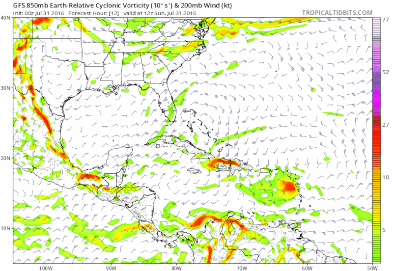
I'd argue, with a ridge to the north, this has a better chance perhaps of going into Honduras or Nicaragua and then into the EPAC?
0 likes
Re: ATL: INVEST 97L - Discussion
wxman57 wrote:Development appears to be almost certain. Main question is whether this has a chance to impact the NW Gulf or just stay down south in Mexico. Models are pointing to a Mexico final landfall at present. Wouldn't rule out Texas, though. We began issuing advisories yesterday, predicting development in the western Caribbean and a 50kt TS striking Tampico next weekend (a bit conservative on intensity to start with).
That is an important factor here. If it stays south over the Bay of Campeche, like the Euro predicts, it may not exceed tropical storm strength. However, if it goes on a more northernly track, it could take advantage of the warm water and low shear and become a hurricane. Mexico and Texas should start monitoring this storm. Either way, it's likely to become Earl.
0 likes
Igor 2010, Sandy 2012, Fay 2014, Gonzalo 2014, Joaquin 2015, Nicole 2016, Humberto 2019, Imelda 2025
I am only a tropical weather enthusiast. My predictions are not official and may or may not be backed by sound meteorological data. For official information, please refer to the NHC and NWS products.
I am only a tropical weather enthusiast. My predictions are not official and may or may not be backed by sound meteorological data. For official information, please refer to the NHC and NWS products.
-
northjaxpro

- S2K Supporter

- Posts: 8900
- Joined: Mon Sep 27, 2010 11:21 am
- Location: Jacksonville, FL
Re: ATL: INVEST 97L - Models
Who is saying we are in a state of panic? All I am saying is to watch it carefully. As we always do anyway. We do not even have a fully mature system yet. I guess some folks just look for anything to exploit you on this forum for Pete's sake
0 likes
NEVER, EVER SAY NEVER in the tropics and weather in general, and most importantly, with life itself!!
________________________________________________________________________________________
Fay 2008 Beryl 2012 Debby 2012 Colin 2016 Hermine 2016 Julia 2016 Matthew 2016 Irma 2017 Dorian 2019
________________________________________________________________________________________
Fay 2008 Beryl 2012 Debby 2012 Colin 2016 Hermine 2016 Julia 2016 Matthew 2016 Irma 2017 Dorian 2019
-
srainhoutx

- S2K Supporter
- Posts: 6919
- Age: 68
- Joined: Sun Jan 14, 2007 11:34 am
- Location: Haywood County, NC
- Contact:
Re: ATL: INVEST 97L - Models
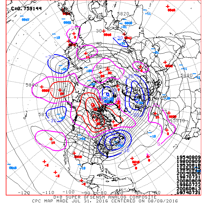
The morning Updated Day 8+ Super Ensembles suggest there may not be as much Ridging to the North as some may think. While it is certainly too soon to contemplate any potential threat without an actual surface circulation to actually track and analyze, interests from Nicaragua, Honduras, Belize, Yucatan Peninsula and the Western Gulf Coast should be monitoring developments closely the next several days. TC Genesis probabilities are near 90% in the Gulf of Honduras Wednesday in Thursday.
0 likes
Carla/Alicia/Jerry(In The Eye)/Michelle/Charley/Ivan/Dennis/Katrina/Rita/Wilma/Ike/Harvey
Member: National Weather Association
Wx Infinity Forums
http://wxinfinity.com/index.php
Facebook.com/WeatherInfinity
Twitter @WeatherInfinity
Member: National Weather Association
Wx Infinity Forums
http://wxinfinity.com/index.php
Facebook.com/WeatherInfinity
Twitter @WeatherInfinity
Re: ATL: INVEST 97L - Discussion
Even if this is buried in the boc, a hurricane may well form. More worried about impacts in boc due to past flood disasters such as diana and stan
0 likes
-
cycloneye

- Admin

- Posts: 149278
- Age: 69
- Joined: Thu Oct 10, 2002 10:54 am
- Location: San Juan, Puerto Rico
ATL: EARL - Recon
First mission as low level invest on the afternoon of August 2.
REPRPD
WEATHER RECONNAISSANCE FLIGHTS
CARCAH, NATIONAL HURRICANE CENTER, MIAMI, FL.
1045 AM EDT SUN 31 JULY 2016
SUBJECT: TROPICAL CYCLONE PLAN OF THE DAY (TCPOD)
VALID 01/1100Z TO 02/1100Z AUGUST 2016
TCPOD NUMBER.....16-066
I. ATLANTIC REQUIREMENTS
1. NEGATIVE RECONNAISSANCE REQUIREMENTS.
2. OUTLOOK FOR SUCCEEDING DAY: PROBABLE LOW-LEVEL INVEST MISSION
OVER WESTERN CARIBBEAN NEAR 16.5N 80.0W FOR 02/1800Z. BEGIN
6-HRLY FIXES AT 03/0600Z IF SYSTEM DEVELOPS.
0 likes
Visit the Caribbean-Central America Weather Thread where you can find at first post web cams,radars
and observations from Caribbean basin members Click Here
and observations from Caribbean basin members Click Here
-
centuryv58

- Tropical Storm

- Posts: 233
- Age: 67
- Joined: Sat Jul 30, 2016 1:24 pm
- Location: Southeast Florida
 Well, I guess the MDR will be active this season after all
-
tolakram
- Admin
- Posts: 20179
- Age: 62
- Joined: Sun Aug 27, 2006 8:23 pm
- Location: Florence, KY (name is Mark)
Re: ATL: INVEST 97L - Discussion
live visible
http://weather.msfc.nasa.gov/cgi-bin/get-goes?satellite=GOES-E%20HURRICANE&lat=14&lon=-67&info=vis&zoom=2&width=1024&height=725&type=Animation&quality=90&palette=ir1.pal&numframes=5&map=county&mapcolor=gray
Might be trying to consolidate an LLC south of the main convection.
http://weather.msfc.nasa.gov/cgi-bin/get-goes?satellite=GOES-E%20HURRICANE&lat=14&lon=-67&info=vis&zoom=2&width=1024&height=725&type=Animation&quality=90&palette=ir1.pal&numframes=5&map=county&mapcolor=gray
Might be trying to consolidate an LLC south of the main convection.
0 likes
M a r k
- - - - -
Join us in chat: Storm2K Chatroom Invite. Android and IOS apps also available.
The posts in this forum are NOT official forecasts and should not be used as such. Posts are NOT endorsed by any professional institution or STORM2K.org. For official information and forecasts, please refer to NHC and NWS products.
-
tolakram
- Admin
- Posts: 20179
- Age: 62
- Joined: Sun Aug 27, 2006 8:23 pm
- Location: Florence, KY (name is Mark)
Re: ATL: INVEST 97L - Discussion
Closer view
http://weather.msfc.nasa.gov/cgi-bin/get-goes?satellite=GOES-E%20HURRICANE&lat=14&lon=-67&info=vis&zoom=1&width=1024&height=725&type=Animation&quality=90&palette=ir1.pal&numframes=7&map=county&mapcolor=gray
It's in the graveyard at the moment, rare for anything to get going in this area in my opinion.
0 likes
M a r k
- - - - -
Join us in chat: Storm2K Chatroom Invite. Android and IOS apps also available.
The posts in this forum are NOT official forecasts and should not be used as such. Posts are NOT endorsed by any professional institution or STORM2K.org. For official information and forecasts, please refer to NHC and NWS products.
- - - - -
Join us in chat: Storm2K Chatroom Invite. Android and IOS apps also available.
The posts in this forum are NOT official forecasts and should not be used as such. Posts are NOT endorsed by any professional institution or STORM2K.org. For official information and forecasts, please refer to NHC and NWS products.
-
Yellow Evan

- Professional-Met
- Posts: 16231
- Age: 27
- Joined: Fri Jul 15, 2011 12:48 pm
- Location: Henderson, Nevada/Honolulu, HI
- Contact:
Re: ATL: INVEST 97L - Discussion
Code: Select all
31/1145 UTC 15.0N 62.7W T1.5/1.5 97L -- Atlantic
0 likes
-
znel52
Re: ATL: INVEST 97L - Discussion
Even if it can't be classified yet it almost feels weird seeing something semi-organized holding together in the Caribbean. Seems like it's been so long!
1 likes
-
Hurricaneman

- Category 5

- Posts: 7404
- Age: 45
- Joined: Tue Aug 31, 2004 3:24 pm
- Location: central florida
Re: ATL: INVEST 97L - Discussion
This already looks like a tropical depression to me but its going to hit the TUTT in about less than 24hrs but after that it seems all systems go for 97L
The posts in this forum are NOT official forecast and should not be used as such. They are just the opinion of the poster and may or may not be backed by sound meteorological data. They are NOT endorsed by any professional institution or STORM2K. For official information, please refer to products from the National Hurricane Center and National Weather Service
The posts in this forum are NOT official forecast and should not be used as such. They are just the opinion of the poster and may or may not be backed by sound meteorological data. They are NOT endorsed by any professional institution or STORM2K. For official information, please refer to products from the National Hurricane Center and National Weather Service
1 likes
-
CaliforniaResident
- Tropical Storm
- Posts: 215
- Joined: Fri Feb 21, 2014 1:47 pm
Re: ATL: INVEST 97L - Discussion
znel52 wrote:Even if it can't be classified yet it almost feels weird seeing something semi-organized holding together in the Caribbean. Seems like it's been so long!
If the timing is right, it could literally explode from almost nothing to a MH in a very short time when it hits that "sweet spot." Could this also be the start of a conveyor belt in the Atlantic for the month of the August?
0 likes


-
Hurricaneman
- Category 5
- Posts: 7404
- Age: 45
- Joined: Tue Aug 31, 2004 3:24 pm
- Location: central florida
Re: ATL: INVEST 97L - Discussion
CaliforniaResident wrote:znel52 wrote:Even if it can't be classified yet it almost feels weird seeing something semi-organized holding together in the Caribbean. Seems like it's been so long!
If the timing is right, it could literally explode from almost nothing to a MH in a very short time when it hits that "sweet spot." Could this also be the start of a conveyor belt in the Atlantic for the month of the August?
If the GFS is correct it could be but let's concentrate on 97L as this could be more than a minor inconvenience for Central America
The posts in this forum are NOT official forecast and should not be used as such. They are just the opinion of the poster and may or may not be backed by sound meteorological data. They are NOT endorsed by any professional institution or STORM2K. For official information, please refer to products from the National Hurricane Center and National Weather Service
0 likes
-
znel52
Re: ATL: INVEST 97L - Discussion
Hurricaneman wrote:This already looks like a tropical depression to me but its going to hit the TUTT in about less than 24hrs but after that it seems all systems go for 97L
The posts in this forum are NOT official forecast and should not be used as such. They are just the opinion of the poster and may or may not be backed by sound meteorological data. They are NOT endorsed by any professional institution or STORM2K. For official information, please refer to products from the National Hurricane Center and National Weather Service
Definitely on the cusp of being classified. I don't believe the LLC is closed off yet but it is close and appears to be getting better organized.
0 likes
-
SEASON_CANCELED

- Category 3

- Posts: 887
- Joined: Mon Jul 06, 2009 5:17 am
- Location: 8 Bit Charlie Sheen
Re: ATL: INVEST 97L - Discussion
I think they will upgrade this next NHC update..with or without flight. Satelittle signature is good and it has good conditions ahead of it
0 likes
i am a big stupid ugly moron with an ugly face and a big butt and my butt stinks and i like to kiss my own butt


Re: ATL: INVEST 97L - Discussion
Hurricaneman wrote:This already looks like a tropical depression to me but its going to hit the TUTT in about less than 24hrs but after that it seems all systems go for 97L
The posts in this forum are NOT official forecast and should not be used as such. They are just the opinion of the poster and may or may not be backed by sound meteorological data. They are NOT endorsed by any professional institution or STORM2K. For official information, please refer to products from the National Hurricane Center and National Weather Service
The anti-cyclone aloft should help some with that. And the shear isn't as bad as yesterday to the west of it.
0 likes
The posts or stuff said are NOT an official forecast. Please look to the NHC and NWS for official forecasts and products.
Floyd-1999, Frances-2004, Jeanne-2004, Fay-2008, Beryl-2012, Debby-2012, Colin-2016, Hermine-2016, Julia-2016, Matthew-2016, Irma-2017, Elsa-2021, Idalia-2023, Debby-2024, Helene-2024.
Go Gators! Go Jags!
Floyd-1999, Frances-2004, Jeanne-2004, Fay-2008, Beryl-2012, Debby-2012, Colin-2016, Hermine-2016, Julia-2016, Matthew-2016, Irma-2017, Elsa-2021, Idalia-2023, Debby-2024, Helene-2024.
Go Gators! Go Jags!
Re: ATL: INVEST 97L - Discussion
Hurricaneman wrote:This already looks like a tropical depression to me but its going to hit the TUTT in about less than 24hrs but after that it seems all systems go for 97L
The posts in this forum are NOT official forecast and should not be used as such. They are just the opinion of the poster and may or may not be backed by sound meteorological data. They are NOT endorsed by any professional institution or STORM2K. For official information, please refer to products from the National Hurricane Center and National Weather Service
The TUTT/ULL has been retrograding westward all along ahead of 97L, it has not been permanent like previous seasons.
GFS and Euro forecast that the UL anticyclone will stay pretty on top of 97L all the way into the BOC.
0 likes
-
cycloneye
- Admin
- Posts: 149278
- Age: 69
- Joined: Thu Oct 10, 2002 10:54 am
- Location: San Juan, Puerto Rico
Re: ATL: INVEST 97L - Discussion
0 likes
Visit the Caribbean-Central America Weather Thread where you can find at first post web cams,radars
and observations from Caribbean basin members Click Here
and observations from Caribbean basin members Click Here
Who is online
Users browsing this forum: No registered users and 76 guests