ATL: EARL - Remnants - Discussion

Moderator: S2k Moderators

Message
Author
User avatar
Hammy
Category 5
Category 5
Posts: 5849
Age: 41
Joined: Fri May 25, 2012 5:25 pm
Contact:

Re: ATL: INVEST 97L - Discussion

#801 Postby Hammy » Tue Aug 02, 2016 12:55 am

AJC3 wrote:
Aric Dunn wrote:
AJC3 wrote:
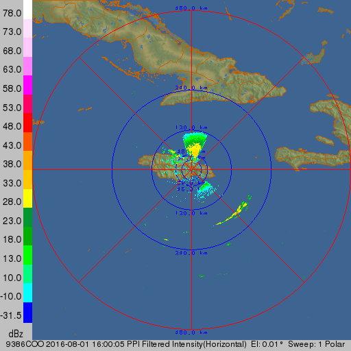
Every piece of data I've looked at says it's not, especially radar. Pretty clear to me.


fair enough. given the circumstance .. that and ill take your word anytime :)


:-)

Give it another 36 hours or so. I suspect that it'll close off as it slows down a little more in it's approach to CENTAM.


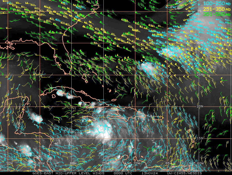
It's headed into stronger shear as per CIMSS--the 30+ kt section is barely moving west while the wave is moving at 25-30mph. I honestly don't think it has more than 24 hours of decent conditions ahead of it, and if it doesn't develop by tomorrow I don't see it doing so after--And I'm certain enough that I've put money on it with someone. :D

Radar is kind of a mixed signal sort of deal--every time it looks closed, new frames come in showing it isn't, and then when I think it isn't, new frames come in showing some easterly component to the rain. I will say the radar presentation overall looks a tad worse over the last half hour as it did an hour or two ago and it may have actually decreased in low-level organization.
0 likes   
The above post is not official and should not be used as such. It is the opinion of the poster and may or may not be backed by sound meteorological data. It is not endorsed by any professional institution or storm2k.org. For official information, please refer to the NHC and NWS products.

Aric Dunn
Category 5
Category 5
Posts: 21238
Age: 42
Joined: Sun Sep 19, 2004 9:58 pm
Location: Ready for the Chase.
Contact:

Re: ATL: INVEST 97L - Discussion

#802 Postby Aric Dunn » Tue Aug 02, 2016 12:56 am

AJC3 wrote:
Aric Dunn wrote: oh yes the physics of it all ... if it were pure thermodynamics based it would be regardless of forward motion, but oh well its all fun :) ... the definitions ...


Easy way to solve this.... LOL

 https://twitter.com/WxmanTony/status/759835130852540417


haha yeah. maybe we should start a new movement ? :P
1 likes   
Note: If I make a post that is brief. Please refer back to previous posts for the analysis or reasoning. I do not re-write/qoute what my initial post said each time.
If there is nothing before... then just ask :)

Space & Atmospheric Physicist, Embry-Riddle Aeronautical University,
I believe the sky is falling...

Aric Dunn
Category 5
Category 5
Posts: 21238
Age: 42
Joined: Sun Sep 19, 2004 9:58 pm
Location: Ready for the Chase.
Contact:

Re: ATL: INVEST 97L - Discussion

#803 Postby Aric Dunn » Tue Aug 02, 2016 12:59 am

get it ? New Movement... :P
3 likes   
Note: If I make a post that is brief. Please refer back to previous posts for the analysis or reasoning. I do not re-write/qoute what my initial post said each time.
If there is nothing before... then just ask :)

Space & Atmospheric Physicist, Embry-Riddle Aeronautical University,
I believe the sky is falling...

User avatar
Hammy
Category 5
Category 5
Posts: 5849
Age: 41
Joined: Fri May 25, 2012 5:25 pm
Contact:

Re: ATL: INVEST 97L - Models

#804 Postby Hammy » Tue Aug 02, 2016 12:59 am

Euro initialized as a closed circulation once again.
0 likes   
The above post is not official and should not be used as such. It is the opinion of the poster and may or may not be backed by sound meteorological data. It is not endorsed by any professional institution or storm2k.org. For official information, please refer to the NHC and NWS products.

User avatar
chaser1
S2K Supporter
S2K Supporter
Posts: 5464
Age: 64
Joined: Sat Oct 15, 2005 5:59 pm
Location: Longwood, Fl

Re: ATL: INVEST 97L - Discussion

#805 Postby chaser1 » Tue Aug 02, 2016 1:05 am

It is my opinion that this is an example of inconsistant tropical cyclone classification. Compared to several GOM classified T.S.'s that come to mind, some lacking significant fundamental required features that define a tropical depression (oh, um.. like CONVECTION for instance lol?), Earl... er 97L I mean exhibits banding features, strong co-located convection, sustained 20-30 + knot winds, relative low surface pressures, data that at minimum would indicate a nearly closed surface low, and being a tropical feature that has clearly not pulsated diurnally but rather maintained and improved its overall appearance over a period of time. Yet, 97L just doesnt meet the scrutiny to even establish it as a tropical depression. Why? Maybe the untimely minimal Solar CME impact to Earth today was at fault of temporarily "zapping" recon equipment along with a host of NOAA buoy's in the path of this disturbance, or who knows... maybe "chem-trails" are at play here LOL :wink: All I know, is that the GOM somehow seems entirelly benign to such classification upgrade challanges.

Okay, rant over - the captain has turned off the fasten seat belt signs - you are free to move about the cabin......
1 likes   
Andy D

(For official information, please refer to the NHC and NWS products.)

TheStormExpert

Re: ATL: INVEST 97L - Models

#806 Postby TheStormExpert » Tue Aug 02, 2016 1:10 am

00z Euro has a developed hurricane making landfall in Belize, I'm not buying it one bit!

Image

Image
0 likes   

User avatar
mobilebay
Category 5
Category 5
Posts: 1853
Age: 51
Joined: Wed Aug 18, 2004 1:22 am
Location: Mobile, Alabama

Re: ATL: INVEST 97L - Discussion

#807 Postby mobilebay » Tue Aug 02, 2016 1:12 am

chaser1 wrote:It is my opinion that this is an example of inconsistant tropical cyclone classification. Compared to several GOM classified T.S.'s that come to mind, some lacking significant fundamental required features that define a tropical depression (oh, um.. like CONVECTION for instance lol?), Earl... er 97L I mean exhibits banding features, strong co-located convection, sustained 20-30 + knot winds, relative low surface pressures, data that at minimum would indicate a nearly closed surface low, and being a tropical feature that has clearly not pulsated diurnally but rather maintained and improved its overall appearance over a period of time. Yet, 97L just doesnt meet the scrutiny to even establish it as a tropical depression. Why? Maybe the untimely minimal Solar CME impact to Earth today was at fault of temporarily "zapping" recon equipment along with a host of NOAA buoy's in the path of this disturbance, or who knows... maybe "chem-trails" are at play here LOL :wink: All I know, is that the GOM somehow seems entirelly benign to such classification upgrade challanges.

Okay, rant over - the captain has turned off the fasten seat belt signs - you are free to move about the cabin......

Lol. I have seen some ragady looking systems classified over the years in the Gulf that was questionable. Its got to have a closed llc or its not a tropical cyclone.
0 likes   

User avatar
Hammy
Category 5
Category 5
Posts: 5849
Age: 41
Joined: Fri May 25, 2012 5:25 pm
Contact:

Re: ATL: INVEST 97L - Models

#808 Postby Hammy » Tue Aug 02, 2016 1:13 am

TheStormExpert wrote:00z Euro has a developed hurricane making landfall in Belize, I'm not buying it one bit!

Image

Image


From what Alyono posted about the earlier Euro run, this one too can probably be scrapped as this still isn't closed (or wasn't at the time the data was input) yet it initialized it as such anyway.
0 likes   
The above post is not official and should not be used as such. It is the opinion of the poster and may or may not be backed by sound meteorological data. It is not endorsed by any professional institution or storm2k.org. For official information, please refer to the NHC and NWS products.

User avatar
Hammy
Category 5
Category 5
Posts: 5849
Age: 41
Joined: Fri May 25, 2012 5:25 pm
Contact:

Re: ATL: INVEST 97L - Discussion

#809 Postby Hammy » Tue Aug 02, 2016 1:22 am

mobilebay wrote:
chaser1 wrote:It is my opinion that this is an example of inconsistant tropical cyclone classification. Compared to several GOM classified T.S.'s that come to mind, some lacking significant fundamental required features that define a tropical depression (oh, um.. like CONVECTION for instance lol?), Earl... er 97L I mean exhibits banding features, strong co-located convection, sustained 20-30 + knot winds, relative low surface pressures, data that at minimum would indicate a nearly closed surface low, and being a tropical feature that has clearly not pulsated diurnally but rather maintained and improved its overall appearance over a period of time. Yet, 97L just doesnt meet the scrutiny to even establish it as a tropical depression. Why? Maybe the untimely minimal Solar CME impact to Earth today was at fault of temporarily "zapping" recon equipment along with a host of NOAA buoy's in the path of this disturbance, or who knows... maybe "chem-trails" are at play here LOL :wink: All I know, is that the GOM somehow seems entirelly benign to such classification upgrade challanges.

Okay, rant over - the captain has turned off the fasten seat belt signs - you are free to move about the cabin......

Lol. I have seen some ragady looking systems classified over the years in the Gulf that was questionable. Its got to have a closed llc or its not a tropical cyclone.


Degree of organization needed (solid LLC vs broad with mesovortices, convection consistency or location relative to the center, etc) seems to be subjective, but I've never seen anything upgraded, Gulf or otherwise, without that west wind being found. After analyzing the radar (going back and fourth between the latest two images and looking at every individual cell/pixel) it seems that there is a very sharp axis, but no closed circulation.

Rough motion estimate.

Image

The wind field is closer than earlier as it seemed more NNE/NE and SSE/SE on the western and eastern side (now it's due north/south wind) but still not quite there.
Last edited by Hammy on Tue Aug 02, 2016 1:24 am, edited 1 time in total.
1 likes   
The above post is not official and should not be used as such. It is the opinion of the poster and may or may not be backed by sound meteorological data. It is not endorsed by any professional institution or storm2k.org. For official information, please refer to the NHC and NWS products.

TheStormExpert

Re: ATL: INVEST 97L - Discussion

#810 Postby TheStormExpert » Tue Aug 02, 2016 1:24 am

2am TWO is basically a copy and paste.

TROPICAL WEATHER OUTLOOK
NWS NATIONAL HURRICANE CENTER MIAMI FL
200 AM EDT TUE AUG 2 2016

For the North Atlantic...Caribbean Sea and the Gulf of Mexico:

A strong tropical wave over the central Caribbean Sea, located about 150 miles south-southwest of Kingston, Jamaica, continues to move quickly westward at about 20 mph. Recent satellite data indicate that the system is producing winds of 40 to 45 mph, but that it still appears to lack a closed surface circulation. Environmental
conditions are expected to be conducive for additional development, and a tropical storm is likely to form later today. An Air Force Reserve Reconnaissance aircraft is scheduled to investigate the system this morning. Regardless of development, locally heavy rainfall and gusty winds, perhaps to tropical storm force, will
continue over portions of Jamaica this morning and reach the Cayman Islands later today. Interests in these areas and elsewhere in the western Caribbean Sea should continue to monitor the progress of this disturbance. For additional information, see High Seas Forecasts issued by the National Weather Service.
* Formation chance through 48 hours...high...80 percent
* Formation chance through 5 days...high...90 percent

&&

High Seas Forecasts issued by the National Weather Service can be found under AWIPS header NFDHSFAT1, WMO header FZNT01 KWBC, and on the Web at http://www.opc.ncep.noaa.gov/shtml/NFDHSFAT1.shtml.

$$
Forecaster Beven
0 likes   

User avatar
chaser1
S2K Supporter
S2K Supporter
Posts: 5464
Age: 64
Joined: Sat Oct 15, 2005 5:59 pm
Location: Longwood, Fl

Re: ATL: INVEST 97L - Models

#811 Postby chaser1 » Tue Aug 02, 2016 1:26 am

TheStormExpert wrote:00z Euro has a developed hurricane making landfall in Belize, I'm not buying it one bit!


I agree, I'm thinking it'll be at least 50 miles north of there.
0 likes   
Andy D

(For official information, please refer to the NHC and NWS products.)

TheStormExpert

Re: ATL: INVEST 97L - Models

#812 Postby TheStormExpert » Tue Aug 02, 2016 1:27 am

Hammy wrote:
TheStormExpert wrote:00z Euro has a developed hurricane making landfall in Belize, I'm not buying it one bit!

Image

Image


From what Alyono posted about the earlier Euro run, this one too can probably be scrapped as this still isn't closed (or wasn't at the time the data was input) yet it initialized it as such anyway.

Like earlier in the season and in the East Pacific the Euro is being too aggressive with systems this year.
0 likes   

User avatar
NDG
S2K Supporter
S2K Supporter
Posts: 15446
Joined: Sun Jul 09, 2006 10:14 pm
Location: Orlando, FL

Re: ATL: INVEST 97L - Discussion

#813 Postby NDG » Tue Aug 02, 2016 1:56 am

I can clearly see what appears to be a very small LLC just to the west of the MLC all along, which was also evident on earlier visible satellite loop before sunset.

Image
0 likes   

User avatar
NDG
S2K Supporter
S2K Supporter
Posts: 15446
Joined: Sun Jul 09, 2006 10:14 pm
Location: Orlando, FL

Re: ATL: INVEST 97L - Models

#814 Postby NDG » Tue Aug 02, 2016 2:13 am

The Euro has been handling the system just fine, looking at its HR zoomed in forecast through the wunderground site it has been showing a very tight small closed circulation. On its 12z forecast it showed very well that in the area where buoy 42058 is that winds were going to be from the east all along as the circulation was going to pass to its north by 100 miles.
0 likes   

StormHunter72
Tropical Storm
Tropical Storm
Posts: 166
Joined: Wed May 25, 2016 6:36 am
Location: Nature Coast

Re: ATL: INVEST 97L - Discussion

#815 Postby StormHunter72 » Tue Aug 02, 2016 2:48 am

It will get buried in Mexico.
0 likes   
The following post is NOT an official forecast and should not be used as such. It is just the opinion of the poster and may or may not be backed by sound meteorological data. It is NOT endorsed by any professional institution including storm2k.org For Official Information please refer to the NHC and NWS products.

User avatar
Hammy
Category 5
Category 5
Posts: 5849
Age: 41
Joined: Fri May 25, 2012 5:25 pm
Contact:

Re: ATL: INVEST 97L - Discussion

#816 Postby Hammy » Tue Aug 02, 2016 3:44 am

Circulation still doesn't look closed on radar, and any circulation that's there appears to already be decoupling and the convective pattern is flattening out north-south as it runs into the wall of shear to the west--time may have run out on development as the upper pattern is not improving at all to the west.

As an aside, I don't see any recon data--was the flight cancelled?
0 likes   
The above post is not official and should not be used as such. It is the opinion of the poster and may or may not be backed by sound meteorological data. It is not endorsed by any professional institution or storm2k.org. For official information, please refer to the NHC and NWS products.

User avatar
Nimbus
Category 5
Category 5
Posts: 5300
Joined: Mon Jul 19, 2004 10:54 am

Re: ATL: INVEST 97L - Discussion

#817 Postby Nimbus » Tue Aug 02, 2016 4:17 am

The small LLC appears to have finally started to outrun the CDO.
Probably a temporary situation as we will be past Jamaica and a forecast slowdown should start soon.
Track should be weak and west till the convection wraps better again.
The ULL/TUTT to the west could hinder development till it fills and the gulf states high bridges over.
0 likes   

Alyono
Professional-Met
Professional-Met
Posts: 6961
Joined: Fri Apr 26, 2013 3:52 pm
Location: Texas Coast

Re: ATL: INVEST 97L - Discussion

#818 Postby Alyono » Tue Aug 02, 2016 5:58 am

looks like no recon until the afternoon
0 likes   

User avatar
NDG
S2K Supporter
S2K Supporter
Posts: 15446
Joined: Sun Jul 09, 2006 10:14 pm
Location: Orlando, FL

Re: ATL: INVEST 97L - Discussion

#819 Postby NDG » Tue Aug 02, 2016 6:07 am

Overnight it sure has run into some windhshear, it is outpacing the UL high & MLC, it needs to slow down so that the UL ridge builds back on top of it.

Image
0 likes   

User avatar
cycloneye
Admin
Admin
Posts: 145332
Age: 68
Joined: Thu Oct 10, 2002 10:54 am
Location: San Juan, Puerto Rico

Re: ATL: INVEST 97L - Discussion

#820 Postby cycloneye » Tue Aug 02, 2016 6:24 am

0 likes   
Visit the Caribbean-Central America Weather Thread where you can find at first post web cams,radars
and observations from Caribbean basin members Click Here


Return to “2016”

Who is online

Users browsing this forum: No registered users and 3 guests