https://twitter.com/philklotzbach/status/760489492998295553
https://twitter.com/weatherchannel/status/760517579278422016
ATL: EARL - Remnants - Discussion
Moderator: S2k Moderators
-
tarheelprogrammer

- S2K Supporter

- Posts: 1793
- Joined: Mon Mar 28, 2016 9:25 pm
- Location: Raleigh, NC area (Garner, NC)
Re: ATL: EARL - Tropical Storm - Discussion
Florida1118 wrote:tarheelprogrammer wrote:srainhoutx wrote:
Wrong. How quickly we forget the 2008 Season.
Of course there are exceptions to every rule. However, for the most part was put in my sentence. Either way shear is causing the LLC to become partly exposed. This has been a major problem for storms lately in this basin.
Yes, there is shear in the basin from time to time. It is to be expected. Not every storm is going to blossom into a Wilma. I think to say that it has been an 11 year "issue" is asinine; it's never going to stop, and it certainly has been an "issue" in every season since records began.
More so in the past 10.5 years but it is just a hunch. I am no expert but it seems to be the case. Shear in the western Atlantic/Caribbean has been extremely high for a while with the occasional year here or there where it is not.
0 likes
My posts are not official forecasts. They are just my opinion and may or may not be backed by sound meteorological data. They are NOT endorsed by any professional institution or storm2k.org. For official information, please refer to the NHC and NWS products.
-
Aric Dunn
- Category 5

- Posts: 21238
- Age: 43
- Joined: Sun Sep 19, 2004 9:58 pm
- Location: Ready for the Chase.
- Contact:
Re: ATL: EARL - Tropical Storm - Discussion
tarheelprogrammer wrote:Aric Dunn wrote:tarheelprogrammer wrote:
Of course there are exceptions to every rule. However, for the most part was put in my sentence. Either way shear is causing the LLC to become partly exposed. This has been a major problem for storms lately in this basin.
however this is slightly different. its not mid of upper level shear its actually quite low. this is all low level shear .. kind of self induced from its forward motion.
That is true but still shear is shear lol I think and this storm is even creating its own.Let us see what the center pass shows.
upper level winds are under 10kts mostly 5kts its ideal for strengthening once it slows down.
0 likes
Note: If I make a post that is brief. Please refer back to previous posts for the analysis or reasoning. I do not re-write/qoute what my initial post said each time.
If there is nothing before... then just ask
Space & Atmospheric Physicist, Embry-Riddle Aeronautical University,
I believe the sky is falling...
If there is nothing before... then just ask
Space & Atmospheric Physicist, Embry-Riddle Aeronautical University,
I believe the sky is falling...
-
TheStormExpert
Re: ATL: EARL - Tropical Storm - Discussion
TS Earl forming where it did in the Caribbean is pretty typical for any given season at this time of year or anytime in general.
https://twitter.com/MichaelRLowry/status/760509516341542913
https://twitter.com/MichaelRLowry/status/760509516341542913
0 likes
-
tarheelprogrammer
- S2K Supporter
- Posts: 1793
- Joined: Mon Mar 28, 2016 9:25 pm
- Location: Raleigh, NC area (Garner, NC)
Re: ATL: EARL - Tropical Storm - Discussion
Aric Dunn wrote:tarheelprogrammer wrote:Aric Dunn wrote:
however this is slightly different. its not mid of upper level shear its actually quite low. this is all low level shear .. kind of self induced from its forward motion.
That is true but still shear is shear lol I think and this storm is even creating its own.
upper level winds are under 10kts mostly 5kts its ideal for strengthening once it slows down.
We shall see but I hope I am right for the sake of the people in its path.
0 likes
My posts are not official forecasts. They are just my opinion and may or may not be backed by sound meteorological data. They are NOT endorsed by any professional institution or storm2k.org. For official information, please refer to the NHC and NWS products.
-
Aric Dunn
- Category 5
- Posts: 21238
- Age: 43
- Joined: Sun Sep 19, 2004 9:58 pm
- Location: Ready for the Chase.
- Contact:
Re: ATL: EARL - Tropical Storm - Discussion
not quite a full pass yet. but initial data.. pressure 999mb so far with a solid pass . last pass missed the center quite a bit.
1 likes
Note: If I make a post that is brief. Please refer back to previous posts for the analysis or reasoning. I do not re-write/qoute what my initial post said each time.
If there is nothing before... then just ask
Space & Atmospheric Physicist, Embry-Riddle Aeronautical University,
I believe the sky is falling...
If there is nothing before... then just ask
Space & Atmospheric Physicist, Embry-Riddle Aeronautical University,
I believe the sky is falling...
-
cycloneye

- Admin

- Posts: 149304
- Age: 69
- Joined: Thu Oct 10, 2002 10:54 am
- Location: San Juan, Puerto Rico
Re: ATL: EARL - Recon
URNT15 KNHC 021725
AF303 02DDA INVEST HDOB 45 20160802
171500 1630N 08056W 8425 01566 0087 +176 +137 067036 038 037 000 00
171530 1628N 08056W 8428 01564 0080 +184 +138 057033 035 038 000 00
171600 1627N 08055W 8439 01548 0071 +193 +138 055033 033 039 000 00
171630 1626N 08054W 8433 01554 0073 +186 +140 054033 034 039 000 00
171700 1624N 08053W 8429 01554 0068 +187 +142 050033 035 038 000 00
171730 1623N 08052W 8428 01552 0068 +182 +144 046030 032 038 000 00
171800 1622N 08051W 8438 01541 0062 +188 +145 047030 031 039 000 00
171830 1620N 08049W 8429 01545 0054 +194 +145 044028 029 040 000 00
171900 1619N 08048W 8434 01535 0048 +195 +147 037023 027 036 001 00
171930 1618N 08047W 8432 01534 0042 +196 +148 029022 023 032 001 00
172000 1617N 08045W 8428 01532 0029 +208 +149 010018 022 030 000 03
172030 1617N 08044W 8438 01517 0021 +216 +150 024007 015 024 000 03
172100 1616N 08042W 8425 01530 0022 +211 +153 211003 008 023 000 00
172130 1616N 08041W 8434 01526 0036 +197 +155 223014 018 029 001 00
172200 1615N 08039W 8433 01534 0052 +183 +157 201019 019 032 001 00
172230 1614N 08038W 8435 01537 0060 +179 +156 188020 021 030 001 03
172300 1613N 08038W 8429 01545 0057 +180 +154 189016 019 /// /// 03
172330 1614N 08039W 8191 01771 0036 +173 +151 210013 016 /// /// 03
172400 1615N 08041W 7865 02119 0015 +174 +147 190007 013 /// /// 03
172430 1616N 08042W 7550 02465 9990 +176 +143 078008 011 /// /// 03
$$
0 likes
Visit the Caribbean-Central America Weather Thread where you can find at first post web cams,radars
and observations from Caribbean basin members Click Here
and observations from Caribbean basin members Click Here
-
Aric Dunn
- Category 5
- Posts: 21238
- Age: 43
- Joined: Sun Sep 19, 2004 9:58 pm
- Location: Ready for the Chase.
- Contact:
Re: ATL: EARL - Tropical Storm - Discussion
odd they did a sharp turn around in the center and looks like they are headed home..
Also latest images showing convection starting to fire right over the center.. could see a large burst.
Also latest images showing convection starting to fire right over the center.. could see a large burst.
0 likes
Note: If I make a post that is brief. Please refer back to previous posts for the analysis or reasoning. I do not re-write/qoute what my initial post said each time.
If there is nothing before... then just ask
Space & Atmospheric Physicist, Embry-Riddle Aeronautical University,
I believe the sky is falling...
If there is nothing before... then just ask
Space & Atmospheric Physicist, Embry-Riddle Aeronautical University,
I believe the sky is falling...
-
cycloneye
- Admin
- Posts: 149304
- Age: 69
- Joined: Thu Oct 10, 2002 10:54 am
- Location: San Juan, Puerto Rico
Re: ATL: EARL - Recon

0 likes
Visit the Caribbean-Central America Weather Thread where you can find at first post web cams,radars
and observations from Caribbean basin members Click Here
and observations from Caribbean basin members Click Here

Re: ATL: EARL - Models
12z GFDL brings earl to hurricane status in the BOC and reaches Tampico.
http://www.tropicaltidbits.com/analysis/models/?model=gfdl-p®ion=97L&pkg=mslp_uv850&runtime=2016080212&fh=72&xpos=0&ypos=46
http://www.tropicaltidbits.com/analysis/models/?model=gfdl-p®ion=97L&pkg=mslp_uv850&runtime=2016080212&fh=72&xpos=0&ypos=46
0 likes

Re: ATL: EARL - Tropical Storm - Discussion
Small storms with sharp pressure gradients have an easier time developing once they reach favorable conditions.
0 likes
-
weathaguyry

- Category 5
- Posts: 1273
- Age: 22
- Joined: Wed Jun 15, 2016 5:16 am
- Location: Long Island, NY
Re: ATL: EARL - Tropical Storm - Discussion
Possibly stronger in 2PM advisory, maybe 55mph?
0 likes
My posts are only my opinions and NOT official forecasts. For official forecasts, consult the National Hurricane Center or the National Weather Service.
Irene 11', Sandy 12', Fay 20’, Isaias 20’, Elsa 21’, Henri 21’, Ida 21’
Irene 11', Sandy 12', Fay 20’, Isaias 20’, Elsa 21’, Henri 21’, Ida 21’
-
Aric Dunn
- Category 5
- Posts: 21238
- Age: 43
- Joined: Sun Sep 19, 2004 9:58 pm
- Location: Ready for the Chase.
- Contact:
Re: ATL: EARL - Tropical Storm - Discussion
weathaguyry wrote:Possibly stronger in 2PM advisory, maybe 55mph?
quite likely either 50 or 55
0 likes
Note: If I make a post that is brief. Please refer back to previous posts for the analysis or reasoning. I do not re-write/qoute what my initial post said each time.
If there is nothing before... then just ask
Space & Atmospheric Physicist, Embry-Riddle Aeronautical University,
I believe the sky is falling...
If there is nothing before... then just ask
Space & Atmospheric Physicist, Embry-Riddle Aeronautical University,
I believe the sky is falling...
-
tolakram
- Admin
- Posts: 20179
- Age: 62
- Joined: Sun Aug 27, 2006 8:23 pm
- Location: Florence, KY (name is Mark)
Re: ATL: EARL - Tropical Storm - Discussion
0 likes
M a r k
- - - - -
Join us in chat: Storm2K Chatroom Invite. Android and IOS apps also available.
The posts in this forum are NOT official forecasts and should not be used as such. Posts are NOT endorsed by any professional institution or STORM2K.org. For official information and forecasts, please refer to NHC and NWS products.
-
TheStormExpert
Re: ATL: EARL - Models
0 likes
-
cycloneye
- Admin
- Posts: 149304
- Age: 69
- Joined: Thu Oct 10, 2002 10:54 am
- Location: San Juan, Puerto Rico
Re: ATL: EARL - Recon
URNT15 KNHC 021735
AF303 02DDA INVEST HDOB 46 20160802
172500 1617N 08043W 7249 02813 9983 +159 +139 041019 021 /// /// 03
172530 1619N 08044W 6988 03136 9980 +149 +135 047019 021 027 001 00
172600 1620N 08046W 6950 03185 9995 +140 +132 050022 024 033 001 00
172630 1622N 08047W 6971 03164 0004 +130 +128 042025 026 040 000 01
172700 1623N 08049W 6953 03184 //// +110 //// 034027 028 043 001 01
172730 1625N 08051W 6968 03172 //// +107 //// 040031 032 044 000 01
172800 1626N 08052W 6969 03173 //// +108 //// 049032 033 044 000 01
172830 1628N 08054W 6969 03177 //// +110 //// 048032 033 043 001 01
172900 1630N 08056W 6966 03183 0052 +113 +109 042034 034 038 000 00
172930 1631N 08057W 6966 03184 0058 +108 +106 051037 038 039 000 01
173000 1633N 08059W 6964 03188 0062 +107 +103 050033 036 039 000 00
173030 1634N 08101W 6969 03184 0073 +101 +100 053029 032 038 000 01
173100 1636N 08103W 6966 03189 0074 +097 //// 056030 030 037 000 01
173130 1638N 08104W 6967 03185 //// +094 //// 060030 030 033 000 01
173200 1639N 08106W 6967 03189 0087 +094 +091 052027 030 033 000 00
173230 1641N 08108W 6970 03188 0089 +095 +088 052026 027 032 000 00
173300 1643N 08109W 6965 03195 0086 +098 +085 055025 026 032 000 00
173330 1644N 08111W 6967 03192 0088 +099 +083 058025 026 032 000 00
173400 1646N 08113W 6966 03194 0084 +100 +081 061026 026 032 000 00
173430 1648N 08115W 6968 03192 0078 +106 +079 063025 026 033 000 00
0 likes
Visit the Caribbean-Central America Weather Thread where you can find at first post web cams,radars
and observations from Caribbean basin members Click Here
and observations from Caribbean basin members Click Here
-
cycloneye
- Admin
- Posts: 149304
- Age: 69
- Joined: Thu Oct 10, 2002 10:54 am
- Location: San Juan, Puerto Rico
Re: ATL: EARL - Recon
Mission is over.
0 likes
Visit the Caribbean-Central America Weather Thread where you can find at first post web cams,radars
and observations from Caribbean basin members Click Here
and observations from Caribbean basin members Click Here


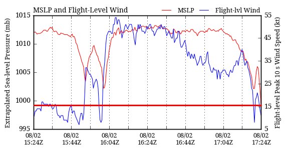
Re: ATL: EARL - Tropical Storm - Discussion
Recon measured 999-998mbs on a recent pass:
https://pbs.twimg.com/media/Co3xc6aW8AY0ZyA.jpg
https://pbs.twimg.com/media/Co3xc6aW8AY0ZyA.jpg
0 likes
The posts or stuff said are NOT an official forecast. Please look to the NHC and NWS for official forecasts and products.
Floyd-1999, Frances-2004, Jeanne-2004, Fay-2008, Beryl-2012, Debby-2012, Colin-2016, Hermine-2016, Julia-2016, Matthew-2016, Irma-2017, Elsa-2021, Idalia-2023, Debby-2024, Helene-2024.
Go Gators! Go Jags!
Floyd-1999, Frances-2004, Jeanne-2004, Fay-2008, Beryl-2012, Debby-2012, Colin-2016, Hermine-2016, Julia-2016, Matthew-2016, Irma-2017, Elsa-2021, Idalia-2023, Debby-2024, Helene-2024.
Go Gators! Go Jags!

Re: ATL: EARL - Tropical Storm - Discussion
JaxGator wrote:Recon measured 999-998mbs on a recent pass:
https://pbs.twimg.com/media/Co3xc6aW8AY0ZyA.jpg
not a valid reading as it was measured during a climb
1 likes
-
Aric Dunn
- Category 5
- Posts: 21238
- Age: 43
- Joined: Sun Sep 19, 2004 9:58 pm
- Location: Ready for the Chase.
- Contact:
Re: ATL: EARL - Tropical Storm - Discussion
Alyono wrote:JaxGator wrote:Recon measured 999-998mbs on a recent pass:
https://pbs.twimg.com/media/Co3xc6aW8AY0ZyA.jpg
not a valid reading as it was measured during a climb
officially the last pass was 1002 mb
and NHC raised winds to 50mph as expected.
0 likes
Note: If I make a post that is brief. Please refer back to previous posts for the analysis or reasoning. I do not re-write/qoute what my initial post said each time.
If there is nothing before... then just ask
Space & Atmospheric Physicist, Embry-Riddle Aeronautical University,
I believe the sky is falling...
If there is nothing before... then just ask
Space & Atmospheric Physicist, Embry-Riddle Aeronautical University,
I believe the sky is falling...
Who is online
Users browsing this forum: No registered users and 131 guests