Gulf Coast Disturbance (early August)

This is the general tropical discussion area. Anyone can take their shot at predicting a storms path.

Moderator: S2k Moderators

Forum rules

The posts in this forum are NOT official forecasts and should not be used as such. They are just the opinion of the poster and may or may not be backed by sound meteorological data. They are NOT endorsed by any professional institution or STORM2K. For official information, please refer to products from the National Hurricane Center and National Weather Service.

Help Support Storm2K
Message
Author
User avatar
northjaxpro
S2K Supporter
S2K Supporter
Posts: 8900
Joined: Mon Sep 27, 2010 11:21 am
Location: Jacksonville, FL

Re: Northeastern Gulf of Mexico

#81 Postby northjaxpro » Fri Aug 05, 2016 3:10 pm

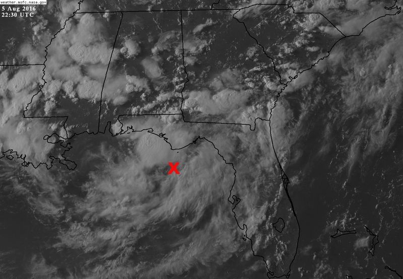
Dean4Storms wrote:Lowest pressures I can find using Wunderground personal stations is West and WSW of Tally which lines up with the spin you see on Satellite there. I'm seeing 29.92"


Yeah, 1015.6 mb was the lowest surface pressure ob I found, which was in Apalachicola from last hour in the Big Bend region. I do not anticipate seeing any notable pressure falls until about another 24-36 hours or so imo. Shear does not look to be hostile over the system for the time being as well.
1 likes   
NEVER, EVER SAY NEVER in the tropics and weather in general, and most importantly, with life itself!!

________________________________________________________________________________________

Fay 2008 Beryl 2012 Debby 2012 Colin 2016 Hermine 2016 Julia 2016 Matthew 2016 Irma 2017 Dorian 2019

User avatar
PTrackerLA
Category 5
Category 5
Posts: 5277
Age: 41
Joined: Thu Oct 10, 2002 8:40 pm
Location: Lafayette, LA

Re: Northeastern Gulf of Mexico

#82 Postby PTrackerLA » Fri Aug 05, 2016 3:20 pm

12z Euro much like 00z still seems rather bizarre. The low deepens over land yet a lot of the biblical precipitation falls offshore and along the coast and on up into central GA. Still shows a 44" maxima with a truly vast area of 10-20"+. I feel like the Euro is trying to signal that we could have TC development in the NE gulf which would seem to make more sense than this massive/sprawling land-based TS 8-) . Just my 2 cents.
1 likes   

User avatar
tropicwatch
Category 5
Category 5
Posts: 3383
Age: 61
Joined: Sat Jun 02, 2007 10:01 am
Location: Panama City Florida
Contact:

Re: Northeastern Gulf of Mexico

#83 Postby tropicwatch » Fri Aug 05, 2016 3:21 pm

Yesterday's lowest pressure at my house in Panama City was 1013mb. I'm looking for it to dip below that tomorrow which should be the start. IMO.
0 likes   
Tropicwatch


Agnes 72', Eloise 75, Elena 85', Kate 85', Charley 86', Florence 88', Beryl 94', Dean 95', Erin 95', Opal 95', Earl 98', Georges 98', Ivan 2004', Arlene 2005', Dennis 2005', Ida 2009' Debby 2012' Irma 2017' Michael 2018'

User avatar
N2FSU
S2K Supporter
S2K Supporter
Posts: 1062
Joined: Thu Sep 04, 2003 2:04 pm
Location: Tallahassee, FL

Re: Northeastern Gulf of Mexico

#84 Postby N2FSU » Fri Aug 05, 2016 3:26 pm

Staying at Panama City Beach all week and the weather is definitely the worst today.

The view SE from my balcony:

Imageg
1 likes   

User avatar
tropicwatch
Category 5
Category 5
Posts: 3383
Age: 61
Joined: Sat Jun 02, 2007 10:01 am
Location: Panama City Florida
Contact:

Re: Northeastern Gulf of Mexico

#85 Postby tropicwatch » Fri Aug 05, 2016 3:29 pm

:uarrow: I got a crick in my neck 8-)
2 likes   
Tropicwatch


Agnes 72', Eloise 75, Elena 85', Kate 85', Charley 86', Florence 88', Beryl 94', Dean 95', Erin 95', Opal 95', Earl 98', Georges 98', Ivan 2004', Arlene 2005', Dennis 2005', Ida 2009' Debby 2012' Irma 2017' Michael 2018'

User avatar
northjaxpro
S2K Supporter
S2K Supporter
Posts: 8900
Joined: Mon Sep 27, 2010 11:21 am
Location: Jacksonville, FL

Re: Northeastern Gulf of Mexico

#86 Postby northjaxpro » Fri Aug 05, 2016 3:31 pm

panamatropicwatch wrote:Yesterday's lowest pressure at my house in Panama City was 1013mb. I'm looking for it to dip below that tomorrow which should be the start. IMO.

There is a little lower pressure a bit farther west in the panhandle currently. I found a 1013.6 mb pressure in the most recent ob in Crestview, the lowest I have seen to this point this afternoon.
0 likes   
NEVER, EVER SAY NEVER in the tropics and weather in general, and most importantly, with life itself!!

________________________________________________________________________________________

Fay 2008 Beryl 2012 Debby 2012 Colin 2016 Hermine 2016 Julia 2016 Matthew 2016 Irma 2017 Dorian 2019

User avatar
northjaxpro
S2K Supporter
S2K Supporter
Posts: 8900
Joined: Mon Sep 27, 2010 11:21 am
Location: Jacksonville, FL

Re: Northeastern Gulf of Mexico

#87 Postby northjaxpro » Fri Aug 05, 2016 3:34 pm

N2FSU, your pic could have been a rather spectacular one, but it is sideways. Give it another attempt.
1 likes   
NEVER, EVER SAY NEVER in the tropics and weather in general, and most importantly, with life itself!!

________________________________________________________________________________________

Fay 2008 Beryl 2012 Debby 2012 Colin 2016 Hermine 2016 Julia 2016 Matthew 2016 Irma 2017 Dorian 2019

User avatar
N2FSU
S2K Supporter
S2K Supporter
Posts: 1062
Joined: Thu Sep 04, 2003 2:04 pm
Location: Tallahassee, FL

Re: Northeastern Gulf of Mexico

#88 Postby N2FSU » Fri Aug 05, 2016 3:39 pm

northjaxpro wrote:N2FSU, your pic could have been a rather spectacular one, but it is sideways. Give it another attempt.


Hmmmmm...shows up correctly on my iPad. I will check into it.
0 likes   

User avatar
ScottNAtlanta
Category 5
Category 5
Posts: 2367
Joined: Sat May 25, 2013 3:11 pm
Location: Atlanta, GA

Re: Northeastern Gulf of Mexico

#89 Postby ScottNAtlanta » Fri Aug 05, 2016 3:49 pm

Interesting that winds at buoy 42036 are out of the WSW

http://www.ndbc.noaa.gov/station_page.php?station=42036
0 likes   
The posts in this forum are NOT official forecast and should not be used as such. They are just the opinion of the poster and may or may not be backed by sound meteorological data. They are NOT endorsed by any professional institution or storm2k.org. For official information, please refer to the NHC and NWS products.

User avatar
northjaxpro
S2K Supporter
S2K Supporter
Posts: 8900
Joined: Mon Sep 27, 2010 11:21 am
Location: Jacksonville, FL

Re: Northeastern Gulf of Mexico

#90 Postby northjaxpro » Fri Aug 05, 2016 4:02 pm

ScottNAtlanta wrote:Interesting that winds at buoy 42036 are out of the WSW

http://www.ndbc.noaa.gov/station_page.php?station=42036


Yes, that buoy is just west of Cedar Key in Apalachee Bay. That is interesting Scott to note that buoy finding a W/SW windshift, albeit the winds are light around 7kts there currently. Is this a sign we are beginning to see the origin of a developing Low pressure there on the trough axis?
0 likes   
NEVER, EVER SAY NEVER in the tropics and weather in general, and most importantly, with life itself!!

________________________________________________________________________________________

Fay 2008 Beryl 2012 Debby 2012 Colin 2016 Hermine 2016 Julia 2016 Matthew 2016 Irma 2017 Dorian 2019

User avatar
SEASON_CANCELED
Category 3
Category 3
Posts: 887
Joined: Mon Jul 06, 2009 5:17 am
Location: 8 Bit Charlie Sheen

Re: Northeastern Gulf of Mexico

#91 Postby SEASON_CANCELED » Fri Aug 05, 2016 4:10 pm

Yeah these water temps are ridiculous. I remember my time share last year water temperatures getting to be like 95 degrees last summer, forget swimming in it. Its just brutal. Pools have to be topped off daily they evaporate so quick.
0 likes   
i am a big stupid ugly moron with an ugly face and a big butt and my butt stinks and i like to kiss my own butt

jlauderdal
S2K Supporter
S2K Supporter
Posts: 7182
Joined: Wed May 19, 2004 5:46 am
Location: NE Fort Lauderdale
Contact:

Re: Northeastern Gulf of Mexico

#92 Postby jlauderdal » Fri Aug 05, 2016 4:13 pm

N2FSU wrote:Staying at Panama City Beach all week and the weather is definitely the worst today.

The view SE from my balcony:

Imageg

powerful system already..knocking the camera over by 90 degrees
4 likes   

USTropics
Professional-Met
Professional-Met
Posts: 2649
Joined: Sun Aug 12, 2007 3:45 am
Location: Florida State University

Re: Northeastern Gulf of Mexico

#93 Postby USTropics » Fri Aug 05, 2016 4:34 pm

The ECMWF 12z operational is completely realistic with the first low staying inland. The GFS and the ECMWF 12z operational runs are actually very similar in bringing this over western Florida and perhaps exiting off the coast of NE Florida.
Image

Image

You'll see in the ensembles prob % of TC genesis that in fact their is equal probability of TC genesis off the EC coast. It's a second low that forms later on that has to be watched in the NE GOM. The ensembles have been bouncing back and forth with development as well (only 20% of the ensembles had development on today's 00z run). TC genesis is still slightly down from yesterday's 12z run but increasing from the 00z and 06z run:
Image

None of the ensembles have development in the next 48 hours:
Image

In about 96 hours the GFS/ECMWF are sniffing out another area of vorticity in the NE GOM, that's where we'll need to watch for development as well:
Image

The GFS keeps this hugging the coastline:
Image
0 likes   

USTropics
Professional-Met
Professional-Met
Posts: 2649
Joined: Sun Aug 12, 2007 3:45 am
Location: Florida State University

Re: Northeastern Gulf of Mexico

#94 Postby USTropics » Fri Aug 05, 2016 4:38 pm

Also, #lesscrinks

Image
0 likes   

User avatar
tropicwatch
Category 5
Category 5
Posts: 3383
Age: 61
Joined: Sat Jun 02, 2007 10:01 am
Location: Panama City Florida
Contact:

Re: Northeastern Gulf of Mexico

#95 Postby tropicwatch » Fri Aug 05, 2016 4:46 pm

:uarrow: yeah great pic 8-)
0 likes   
Tropicwatch


Agnes 72', Eloise 75, Elena 85', Kate 85', Charley 86', Florence 88', Beryl 94', Dean 95', Erin 95', Opal 95', Earl 98', Georges 98', Ivan 2004', Arlene 2005', Dennis 2005', Ida 2009' Debby 2012' Irma 2017' Michael 2018'

Dean4Storms
S2K Supporter
S2K Supporter
Posts: 6358
Age: 62
Joined: Sun Aug 31, 2003 1:01 pm
Location: Miramar Bch. FL

Re: Northeastern Gulf of Mexico

#96 Postby Dean4Storms » Fri Aug 05, 2016 5:26 pm

The 12z ECM EPS Probability of a TD goes up to 60% centered over the very Western FL Panhandle extending out 100 or so miles between the 10th to the 12th. I think like Wxman57 said, that period is likely the biggest threat of something tropical getting going!
0 likes   

User avatar
NDG
S2K Supporter
S2K Supporter
Posts: 15446
Joined: Sun Jul 09, 2006 10:14 pm
Location: Orlando, FL

Re: Northeastern Gulf of Mexico

#97 Postby NDG » Fri Aug 05, 2016 5:52 pm

Will somebody tell the TV Met on Fox 35 Orlando that this disturbance over the GOM is not an Upper Level low, lol.

In another news, I am watching the area I marked on the image below for possible circulation in the mid levels developing, looks fairly tight on satellite and radar.

http://weather.msfc.nasa.gov/cgi-bin/ge ... olor=black
Image
0 likes   

User avatar
N2FSU
S2K Supporter
S2K Supporter
Posts: 1062
Joined: Thu Sep 04, 2003 2:04 pm
Location: Tallahassee, FL

Re: Northeastern Gulf of Mexico

#98 Postby N2FSU » Fri Aug 05, 2016 6:14 pm

USTropics wrote:Also, #lesscrinks

Image


Thanks for fixing it! :D
0 likes   

User avatar
Nimbus
Category 5
Category 5
Posts: 5300
Joined: Mon Jul 19, 2004 10:54 am

Re: Northeastern Gulf of Mexico

#99 Postby Nimbus » Fri Aug 05, 2016 6:19 pm

Big pressure drop at the mid bay buoy near Mobile AL.
Could be slowly digging into the gulf there?

http://www.ndbc.noaa.gov/station_page.php?station=MBLA1
1 likes   

User avatar
stormhunter7
Category 2
Category 2
Posts: 762
Joined: Mon May 26, 2008 3:13 pm
Location: Panama City Beach, Florida
Contact:

Re: Northeastern Gulf of Mexico

#100 Postby stormhunter7 » Fri Aug 05, 2016 6:23 pm

Image

Interesting vortice in that between that convection, which looks to be low or to mid level. NOT upper level. lol
0 likes   
The following post is NOT an official forecast and should not be used as such. It is just the opinion of the poster and may or may not be backed by sound meteorological data. It is NOT endorsed by any professional institution including storm2k.org For Official Information please refer to the NHC and NWS products. http://www.nhc.noaa.gov


Return to “Talkin' Tropics”

Who is online

Users browsing this forum: AnnularCane, Hypercane_Kyle, RomP and 28 guests