Seasonal Indicators (Beyond Day 16): Instability / SST's / MSLP / Steering / Sal

This is the general tropical discussion area. Anyone can take their shot at predicting a storms path.

Moderator: S2k Moderators

Forum rules

The posts in this forum are NOT official forecasts and should not be used as such. They are just the opinion of the poster and may or may not be backed by sound meteorological data. They are NOT endorsed by any professional institution or STORM2K. For official information, please refer to products from the National Hurricane Center and National Weather Service.

Help Support Storm2K
Message
Author
User avatar
blp
Category 5
Category 5
Posts: 2840
Age: 46
Joined: Thu Sep 09, 2004 7:51 pm
Location: Miami, FL
Contact:

Re: Seasonal Indicators (Beyond Day 16): Instability / SST's / MSLP / Steering / Sal

#1301 Postby blp » Sun Aug 07, 2016 11:20 am

stormlover2013 wrote:So your saying the gulf is done??


No not at all. I think the abnormal high pressure will make it hard for waves rolling off Africa to maintain themselves as they progress through the MDR. Close home development like the gulf is more likely due to other favorable factors such as low shear and high SST's. I just think it will be harder to get long track CV type systems.

I actually think October might be the most active month as the high retreats some with the Carribean and Gulf being very favorable.
Last edited by blp on Sun Aug 07, 2016 11:24 am, edited 2 times in total.
0 likes   
The following post is NOT an official forecast and should not be used as such. It is just the opinion of the poster and may or may not be backed by sound meteorological data. It is NOT endorsed by any professional institution including storm2k.org For Official Information please refer to the NHC and NWS products.

LarryWx
S2K Supporter
S2K Supporter
Posts: 6310
Joined: Sun Sep 07, 2003 2:04 pm
Location: GA

Re: Seasonal Indicators (Beyond Day 16): Instability / SST's / MSLP / Steering / Sal

#1302 Postby LarryWx » Sun Aug 07, 2016 11:22 am

With 2016 already at 4 storms (excluding the Jan storm) with the heart of the season (8/15-10/15) still a week from starting, the current season is anything but quiet.
Even if there were to be no NS for the next 2 weeks, the season would still be near to slightly above average with the 4 NS.
0 likes   
Personal Forecast Disclaimer:
The posts in this forum are NOT official forecasts and should not be used as such. They are just the opinion of the poster and may or may not be backed by sound meteorological data. They are NOT endorsed by any professional institution or storm2k.org. For official information, please refer to the NHC and NWS products.

User avatar
tarheelprogrammer
S2K Supporter
S2K Supporter
Posts: 1793
Joined: Mon Mar 28, 2016 9:25 pm
Location: Raleigh, NC area (Garner, NC)

Re: Seasonal Indicators (Beyond Day 16): Instability / SST's / MSLP / Steering / Sal

#1303 Postby tarheelprogrammer » Sun Aug 07, 2016 11:58 am

LarryWx wrote:With 2016 already at 4 storms (excluding the Jan storm) with the heart of the season (8/15-10/15) still a week from starting, the current season is anything but quiet.
Even if there were to be no NS for the next 2 weeks, the season would still be near to slightly above average with the 4 NS.


ACE is below average and no named storms for a few weeks will only dig a bigger hole.
0 likes   
My posts are not official forecasts. They are just my opinion and may or may not be backed by sound meteorological data. They are NOT endorsed by any professional institution or storm2k.org. For official information, please refer to the NHC and NWS products.

LarryWx
S2K Supporter
S2K Supporter
Posts: 6310
Joined: Sun Sep 07, 2003 2:04 pm
Location: GA

Re: Seasonal Indicators (Beyond Day 16): Instability / SST's / MSLP / Steering / Sal

#1304 Postby LarryWx » Sun Aug 07, 2016 12:20 pm

tarheelprogrammer wrote:
LarryWx wrote:With 2016 already at 4 storms (excluding the Jan storm) with the heart of the season (8/15-10/15) still a week from starting, the current season is anything but quiet.
Even if there were to be no NS for the next 2 weeks, the season would still be near to slightly above average with the 4 NS.


ACE is below average and no named storms for a few weeks will only dig a bigger hole.


So, in terms of ACE, 2016 to date has been quiet relative to average for 8/7? I didn't know that. How far below average is it?

I, of course, was talking about named storms. Since my previous post, I did some more research. This time I only looked at the 15 seasons of the very active era (since 1995) excluding El Nino seasons: 95, 96, 98-01, 03, 05, 07, 08, 10-14

Avg # of NS by 8/7: 3.6
Avg # of NS as of 8/21: 5.1

So, just considering this recent active period, we're right at about the average of 3.6 with 2016's 4 (excluding Alex). Only 5 seasons had more than 4 NS as of 8/7: 95, 05, 08, 11, 12 vs 8 with fewer than 4 NS. The very active years of 1998-2000 all had only 1 NS as of 8/7 and only 3-4 NS as of 8/21! Also, all 2016 needs is one more NS to be at avg as of 8/21 for the recent active period, alone.

In summary, even during recent quite active/memorable/historic seasons, there often has been no major level of activity even two weeks out from now. These seasons were made primarily after 8/7 and to a lesser extent even after 8/21!
0 likes   
Personal Forecast Disclaimer:
The posts in this forum are NOT official forecasts and should not be used as such. They are just the opinion of the poster and may or may not be backed by sound meteorological data. They are NOT endorsed by any professional institution or storm2k.org. For official information, please refer to the NHC and NWS products.

User avatar
tarheelprogrammer
S2K Supporter
S2K Supporter
Posts: 1793
Joined: Mon Mar 28, 2016 9:25 pm
Location: Raleigh, NC area (Garner, NC)

Re: Seasonal Indicators (Beyond Day 16): Instability / SST's / MSLP / Steering / Sal

#1305 Postby tarheelprogrammer » Sun Aug 07, 2016 1:03 pm

LarryWx wrote:
tarheelprogrammer wrote:
LarryWx wrote:With 2016 already at 4 storms (excluding the Jan storm) with the heart of the season (8/15-10/15) still a week from starting, the current season is anything but quiet.
Even if there were to be no NS for the next 2 weeks, the season would still be near to slightly above average with the 4 NS.


ACE is below average and no named storms for a few weeks will only dig a bigger hole.


So, in terms of ACE, 2016 to date has been quiet relative to average for 8/7? I didn't know that. How far below average is it?

I, of course, was talking about named storms. Since my previous post, I did some more research. This time I only looked at the 15 seasons of the very active era (since 1995) excluding El Nino seasons: 95, 96, 98-01, 03, 05, 07, 08, 10-14

Avg # of NS by 8/7: 3.6
Avg # of NS as of 8/21: 5.1

So, just considering this recent active period, we're right at about the average of 3.6 with 2016's 4 (excluding Alex). Only 5 seasons had more than 4 NS as of 8/7: 95, 05, 08, 11, 12 vs 8 with fewer than 4 NS. The very active years of 1998-2000 all had only 1 NS as of 8/7 and only 3-4 NS as of 8/21! Also, all 2016 needs is one more NS to be at avg as of 8/21 for the recent active period, alone.

In summary, even during recent quite active/memorable/historic seasons, there often has been no major level of activity even two weeks out from now. These seasons were made primarily after 8/7 and to a lesser extent even after 8/21!


ACE is below average even after a fast start and even Earl did not add much. Without Alex in January it is quite a bit below. No signs of anything changing and ACE hole is growing.This season might surprise people.
0 likes   
My posts are not official forecasts. They are just my opinion and may or may not be backed by sound meteorological data. They are NOT endorsed by any professional institution or storm2k.org. For official information, please refer to the NHC and NWS products.

User avatar
NDG
S2K Supporter
S2K Supporter
Posts: 15446
Joined: Sun Jul 09, 2006 10:14 pm
Location: Orlando, FL

Re: Seasonal Indicators (Beyond Day 16): Instability / SST's / MSLP / Steering / Sal

#1306 Postby NDG » Sun Aug 07, 2016 2:17 pm

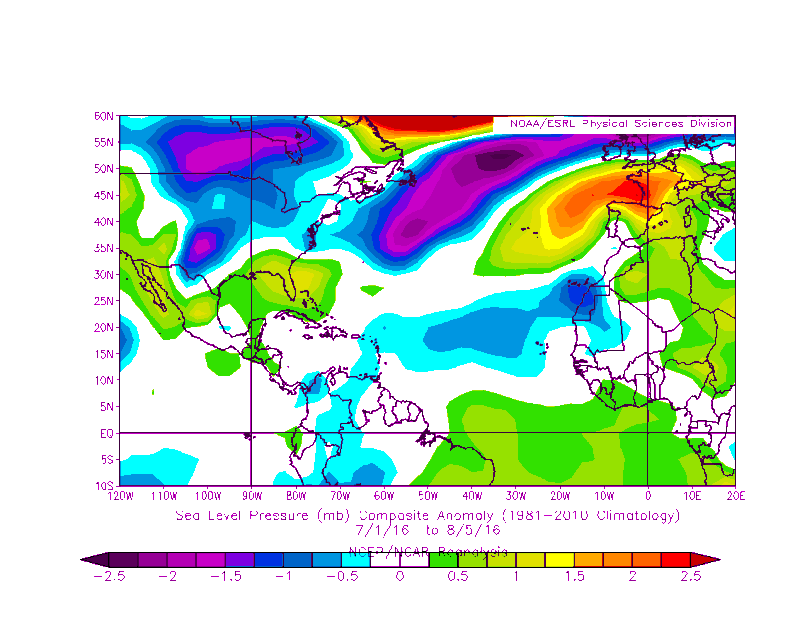
blp wrote:There is an incredibly abnormal high pressure in the Atlantic this year. I went back 30 years and this appears the worst by far. Last year had the worst shear ever in the Carribean and this year might be the worst for High Pressure. Euro is so far correct in its pre season projection.

Things can change and not an expert but it appears to me this will impact the season especially in the MDR.

Image


The image is for H50, did you meant to show surface pressures?
0 likes   

User avatar
NDG
S2K Supporter
S2K Supporter
Posts: 15446
Joined: Sun Jul 09, 2006 10:14 pm
Location: Orlando, FL

Re: Seasonal Indicators (Beyond Day 16): Instability / SST's / MSLP / Steering / Sal

#1307 Postby NDG » Sun Aug 07, 2016 2:34 pm

Here is the correct image that shows surface pressure anomalies for the same time period, average to below average for the MDR.

Image
1 likes   

User avatar
blp
Category 5
Category 5
Posts: 2840
Age: 46
Joined: Thu Sep 09, 2004 7:51 pm
Location: Miami, FL
Contact:

Re: Seasonal Indicators (Beyond Day 16): Instability / SST's / MSLP / Steering / Sal

#1308 Postby blp » Sun Aug 07, 2016 3:07 pm

NDG wrote:
blp wrote:There is an incredibly abnormal high pressure in the Atlantic this year. I went back 30 years and this appears the worst by far. Last year had the worst shear ever in the Carribean and this year might be the worst for High Pressure. Euro is so far correct in its pre season projection.

Things can change and not an expert but it appears to me this will impact the season especially in the MDR.

[]http://oi64.tinypic.com/2hfkh9g.jpg[/img]


The image is for H50, did you meant to show surface pressures?


I was actually referring to the H50. I think it is disrupting these waves by creating stronger trade winds and also continuing to foster that stable dry mid level air that has been so dominant these past few years. I agree the surface pressure looks OK so far.
0 likes   
The following post is NOT an official forecast and should not be used as such. It is just the opinion of the poster and may or may not be backed by sound meteorological data. It is NOT endorsed by any professional institution including storm2k.org For Official Information please refer to the NHC and NWS products.

CYCLONE MIKE
Category 5
Category 5
Posts: 2183
Joined: Tue Aug 31, 2004 6:04 pm
Location: Gonzales, LA

Re: Seasonal Indicators (Beyond Day 16): Instability / SST's / MSLP / Steering / Sal

#1309 Postby CYCLONE MIKE » Sun Aug 07, 2016 3:30 pm

Last several long range runs show nothing remotely close to happening anywhere and it is pushing deep into August now. If we are sitting here in two weeks looking at the same picture it might be time to have the fat lady start warming up.
1 likes   
This post is NOT AN OFFICIAL FORECAST and should not be used as such. It is just the opinion of the poster and may or may not be backed by sound meteorological data. It is NOT endorsed by any professional institution including storm2k.org. For Official Information please refer to the NHC and NWS products.

User avatar
tarheelprogrammer
S2K Supporter
S2K Supporter
Posts: 1793
Joined: Mon Mar 28, 2016 9:25 pm
Location: Raleigh, NC area (Garner, NC)

Re: Seasonal Indicators (Beyond Day 16): Instability / SST's / MSLP / Steering / Sal

#1310 Postby tarheelprogrammer » Sun Aug 07, 2016 3:37 pm

CYCLONE MIKE wrote:Last several long range runs show nothing remotely close to happening anywhere and it is pushing deep into August now. If we are sitting here in two weeks looking at the same picture it might be time to have the fat lady start warming up.


I have been hitting on the fact that the pattern is not changing and the eastern pacific seems to be in its own version of the Atlantic's 2005 season. These past few seasons have seen dry stable air, shear, and very warm SSTs but in the end SSTs produce nothing without storms to use it. Until we see a shift in the models away from stable air and shear I would assume it is going to happen and continue to happen. The CFS is going to bust in terms of its shear and pressure predictions from earlier this year. Proving yet again that it is still very much a guessing game in the tropics.

Edit:
 https://twitter.com/EricBlake12/status/762313200733855745


Last edited by tarheelprogrammer on Sun Aug 07, 2016 3:46 pm, edited 1 time in total.
0 likes   
My posts are not official forecasts. They are just my opinion and may or may not be backed by sound meteorological data. They are NOT endorsed by any professional institution or storm2k.org. For official information, please refer to the NHC and NWS products.

User avatar
Darvince
Tropical Storm
Tropical Storm
Posts: 184
Joined: Wed Sep 02, 2015 10:25 pm
Location: Phoenix AZ

Re: Seasonal Indicators (Beyond Day 16): Instability / SST's / MSLP / Steering / Sal

#1311 Postby Darvince » Sun Aug 07, 2016 3:43 pm

blp wrote:There is an incredibly abnormal high pressure in the Atlantic this year. I went back 30 years and this appears the worst by far. Last year had the worst shear ever in the Carribean and this year might be the worst for High Pressure. Euro is so far correct in its pre season projection.

Things can change and not an expert but it appears to me this will impact the season especially in the MDR.

Image

As this is 500mb heights rather than surface pressures, the virtually ubiquitous high anomalies you see are to be expected because 500mb heights are rising due to global warming.
1 likes   
:craz:

User avatar
Steve
S2K Supporter
S2K Supporter
Posts: 9621
Joined: Sat Apr 05, 2003 11:41 pm
Location: Not a state-caster

Re: Seasonal Indicators (Beyond Day 16): Instability / SST's / MSLP / Steering / Sal

#1312 Postby Steve » Sun Aug 07, 2016 4:25 pm

CYCLONE MIKE wrote:Last several long range runs show nothing remotely close to happening anywhere and it is pushing deep into August now. If we are sitting here in two weeks looking at the same picture it might be time to have the fat lady start warming up.


Lol. Hey Mike. We probably have 8/9 more named storms. I still think just east of us over to Bahamas is the hotspot, but the way the pattern is evolving, the Western Caribbean could launch something into the Gulf a few weeks down the road. I think the shot at some big stuff will come between near the end of August through mid-October. I also think we will get a named storm off the SE US coast in 3-4 days. Y'all gotta be patient. We're at 8 ACE. There's probably 80-100 points to go.
1 likes   

psyclone
S2K Supporter
S2K Supporter
Posts: 4762
Joined: Wed Aug 24, 2005 9:04 pm
Location: palm harbor fl

Re: Seasonal Indicators (Beyond Day 16): Instability / SST's / MSLP / Steering / Sal

#1313 Postby psyclone » Sun Aug 07, 2016 4:50 pm

the general pattern is we post in the active storms thread and then when said storm landfalls/dissipates we pivot back here and discuss why there will be no more storms. I suspect we'll get some action this year. we just started climbing the climo mountain a week ago. I suppose the remainder of the season could be dead but that's probably not the most likely outcome. even if the season is near average we'll have some action to track. It is a mistake (IMO) to expect recent quiet seasons to be the norm...just as it was to expect non stop hyper activity following the 2005 season. things just tend to average out over time...but we're impatient creatures. Another way to think about this is to recall the dates of infamous storms...the overwhelming majority of them were after this date. How many of those years featured a vapid basin at this point in time? perhaps the best way to temper impatience is with a healthy dose of historical perspective.
4 likes   

User avatar
centuryv58
Tropical Storm
Tropical Storm
Posts: 233
Age: 67
Joined: Sat Jul 30, 2016 1:24 pm
Location: Southeast Florida

Re: Seasonal Indicators (Beyond Day 16): Instability / SST's / MSLP / Steering / Sal

#1314 Postby centuryv58 » Sun Aug 07, 2016 5:00 pm

psyclone wrote:the general pattern is we post in the active storms thread and then when said storm landfalls/dissipates we pivot back here and discuss why there will be no more storms. I suspect we'll get some action this year. we just started climbing the climo mountain a week ago. I suppose the remainder of the season could be dead but that's probably not the most likely outcome. even if the season is near average we'll have some action to track. It is a mistake (IMO) to expect recent quiet seasons to be the norm...just as it was to expect non stop hyper activity following the 2005 season. things just tend to average out over time...but we're impatient creatures. Another way to think about this is to recall the dates of infamous storms...the overwhelming majority of them were after this date. How many of those years featured a vapid basin at this point in time? perhaps the best way to temper impatience is with a healthy dose of historical perspective.


Your post makes a great deal of sense. Thanks for the input!
0 likes   

LarryWx
S2K Supporter
S2K Supporter
Posts: 6310
Joined: Sun Sep 07, 2003 2:04 pm
Location: GA

Re: Seasonal Indicators (Beyond Day 16): Instability / SST's / MSLP / Steering / Sal

#1315 Postby LarryWx » Sun Aug 07, 2016 6:20 pm

psyclone wrote:the general pattern is we post in the active storms thread and then when said storm landfalls/dissipates we pivot back here and discuss why there will be no more storms. I suspect we'll get some action this year. we just started climbing the climo mountain a week ago. I suppose the remainder of the season could be dead but that's probably not the most likely outcome. even if the season is near average we'll have some action to track. It is a mistake (IMO) to expect recent quiet seasons to be the norm...just as it was to expect non stop hyper activity following the 2005 season. things just tend to average out over time...but we're impatient creatures. Another way to think about this is to recall the dates of infamous storms...the overwhelming majority of them were after this date. How many of those years featured a vapid basin at this point in time? perhaps the best way to temper impatience is with a healthy dose of historical perspective.


I say just look at the active years 1998-2000 at this stage, all of which had only one NS vs the 4 NS 2016 has already had!
0 likes   
Personal Forecast Disclaimer:
The posts in this forum are NOT official forecasts and should not be used as such. They are just the opinion of the poster and may or may not be backed by sound meteorological data. They are NOT endorsed by any professional institution or storm2k.org. For official information, please refer to the NHC and NWS products.

TheStormExpert

Re: Seasonal Indicators (Beyond Day 16): Instability / SST's / MSLP / Steering / Sal

#1316 Postby TheStormExpert » Sun Aug 07, 2016 6:35 pm

tarheelprogrammer wrote:
CYCLONE MIKE wrote:Last several long range runs show nothing remotely close to happening anywhere and it is pushing deep into August now. If we are sitting here in two weeks looking at the same picture it might be time to have the fat lady start warming up.


I have been hitting on the fact that the pattern is not changing and the eastern pacific seems to be in its own version of the Atlantic's 2005 season. These past few seasons have seen dry stable air, shear, and very warm SSTs but in the end SSTs produce nothing without storms to use it. Until we see a shift in the models away from stable air and shear I would assume it is going to happen and continue to happen. The CFS is going to bust in terms of its shear and pressure predictions from earlier this year. Proving yet again that it is still very much a guessing game in the tropics.

It's not like the storms in the East Pacific have much quality when compared to the last two seasons. It's quantity over quality for the East Pacific so far this season.
0 likes   

User avatar
PTrackerLA
Category 5
Category 5
Posts: 5277
Age: 41
Joined: Thu Oct 10, 2002 8:40 pm
Location: Lafayette, LA

Re: Seasonal Indicators (Beyond Day 16): Instability / SST's / MSLP / Steering / Sal

#1317 Postby PTrackerLA » Sun Aug 07, 2016 6:39 pm

Also one thing to remember is systems can start to show up in the models unexpectedly. The upper low that eventually became Joaquin last year had virtually no model support but Mother Nature had other plans. I also believe that models have improved significantly in the past 10 years which leads to much less "phantom storms" than we were once used to seeing in long range models. Even before August 1st some experts were thinking it might not be until the last third of August that the basin starts to light up. Let's see where things stand in a week from now.
1 likes   

User avatar
Ntxw
Storm2k Moderator
Storm2k Moderator
Posts: 22786
Joined: Wed Oct 21, 2009 6:34 pm
Location: DFW, Texas

Re: Seasonal Indicators (Beyond Day 16): Instability / SST's / MSLP / Steering / Sal

#1318 Postby Ntxw » Sun Aug 07, 2016 7:40 pm

TheStormExpert wrote:
tarheelprogrammer wrote:
CYCLONE MIKE wrote:Last several long range runs show nothing remotely close to happening anywhere and it is pushing deep into August now. If we are sitting here in two weeks looking at the same picture it might be time to have the fat lady start warming up.


I have been hitting on the fact that the pattern is not changing and the eastern pacific seems to be in its own version of the Atlantic's 2005 season. These past few seasons have seen dry stable air, shear, and very warm SSTs but in the end SSTs produce nothing without storms to use it. Until we see a shift in the models away from stable air and shear I would assume it is going to happen and continue to happen. The CFS is going to bust in terms of its shear and pressure predictions from earlier this year. Proving yet again that it is still very much a guessing game in the tropics.

It's not like the storms in the East Pacific have much quality when compared to the last two seasons. It's quantity over quality for the East Pacific so far this season.


This is not entirely true. The EPAC has produced several majors and a couple of cat 4s. ACE is nearly double normal so by all metrics it is a quality and quantity season thus far there. If you compare it to last year than yes, but thats record historical pace you're talking about. Its like saying 2004 was a quantity over quality compared to 2005 in the Atlantic.

As far as the Atlantic goes, all metrics is near averages. No reason to think that wont continue, more or less if pace is kept it should be +/- close to average season.
2 likes   
The above post and any post by Ntxw is NOT an official forecast and should not be used as such. It is just the opinion of the poster and may or may not be backed by sound meteorological data. It is NOT endorsed by any professional institution including Storm2k. For official information, please refer to NWS products.

  Help support Storm2K!
Help Support Storm2K

User avatar
Kingarabian
S2K Supporter
S2K Supporter
Posts: 15981
Joined: Sat Aug 08, 2009 3:06 am
Location: Honolulu, Hawaii

Re: Seasonal Indicators (Beyond Day 16): Instability / SST's / MSLP / Steering / Sal

#1319 Postby Kingarabian » Sun Aug 07, 2016 9:00 pm

Ntxw wrote:
This is not entirely true. The EPAC has produced several majors and a couple of cat 4s. ACE is nearly double normal so by all metrics it is a quality and quantity season thus far there. If you compare it to last year than yes, but thats record historical pace you're talking about. Its like saying 2004 was a quantity over quality compared to 2005 in the Atlantic.

As far as the Atlantic goes, all metrics is near averages. No reason to think that wont continue, more or less if pace is kept it should be +/- close to average season.


All that while ENSO is in a cool neutral.
0 likes   
RIP Kobe Bryant

User avatar
blp
Category 5
Category 5
Posts: 2840
Age: 46
Joined: Thu Sep 09, 2004 7:51 pm
Location: Miami, FL
Contact:

Re: Seasonal Indicators (Beyond Day 16): Instability / SST's / MSLP / Steering / Sal

#1320 Postby blp » Sun Aug 07, 2016 10:04 pm

Don't know if this is the best place to post this but the CFS is starting to narrow in on the last week of August to First week of September to turn on the switch. We should start seeing the waves emerge in the GFS in the next three days in the 384hr timeframe lets see this week.

I don't like to use the CFS for specific systems but it seems to show the pattern change everyone is expecting right on time for heart of season.

Sunday
Image

Saturday
Image
0 likes   
The following post is NOT an official forecast and should not be used as such. It is just the opinion of the poster and may or may not be backed by sound meteorological data. It is NOT endorsed by any professional institution including storm2k.org For Official Information please refer to the NHC and NWS products.


Return to “Talkin' Tropics”

Who is online

Users browsing this forum: ElectricStorm, Lizzytiz1, Stratton23, USTropics and 48 guests