
Gulf Coast Disturbance (early August)
Moderator: S2k Moderators
Forum rules

The posts in this forum are NOT official forecasts and should not be used as such. They are just the opinion of the poster and may or may not be backed by sound meteorological data. They are NOT endorsed by any professional institution or STORM2K. For official information, please refer to products from the National Hurricane Center and National Weather Service.
-
gatorcane

- S2K Supporter

- Posts: 23708
- Age: 48
- Joined: Sun Mar 13, 2005 3:54 pm
- Location: Boca Raton, FL
Re: Northeastern Gulf of Mexico
storm total map showing accumulated rainfall:
Last edited by gatorcane on Mon Aug 08, 2016 2:24 pm, edited 1 time in total.
0 likes
-
OntarioEggplant
- Category 1

- Posts: 312
- Joined: Sun Aug 07, 2016 11:16 am
Re: Northeastern Gulf of Mexico
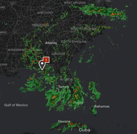
Overall this has not been a big deal compared to the potential that appeared to exist a few days ago...which was a redux of last year's inundation. We've seen nothing like that and we should consider ourselves lucky. ..take a look at the rain estimates on the Tampa radar and you'll see just how close of a shave it was. Now that things are saturated due to previous rain and low evaporative losses, any additional heavy rain will quickly translate into pure runoff and things could stack up quickly...but absent that it appears we may have dodged a bullet here in west central florida...still some time to wait and be vigilant though.
0 likes
-
Dean4Storms
- S2K Supporter
- Posts: 6358
- Age: 63
- Joined: Sun Aug 31, 2003 1:01 pm
- Location: Miramar Bch. FL
Re: Northeastern Gulf of Mexico
OntarioEggplant wrote:Is the Euro still showing 40 inches near NW FL?
No, has backed way off. General 5-10" and most of that hugging the extreme coastline inland maybe 10 miles.
0 likes
-
Dean4Storms
- S2K Supporter
- Posts: 6358
- Age: 63
- Joined: Sun Aug 31, 2003 1:01 pm
- Location: Miramar Bch. FL
Re: Northeastern Gulf of Mexico
Looks like that former LLC that was with the system in the Gulf has now pretty much detached itself from the mess left over in the Gulf and does appear to me turning more westward in central GA.
We have a trough at mid and upper levels left over down there.
We have a trough at mid and upper levels left over down there.
0 likes
-
wxman57

- Moderator-Pro Met

- Posts: 23174
- Age: 68
- Joined: Sat Jun 21, 2003 8:06 pm
- Location: Houston, TX (southwest)
Re: Northeastern Gulf of Mexico
No tropical development in the NE Gulf - just lots of rain for coastal counties/parishes this week. May be a quiet next 2 weeks.
4 likes


Re: Northeastern Gulf of Mexico
Hi all. New to the board.
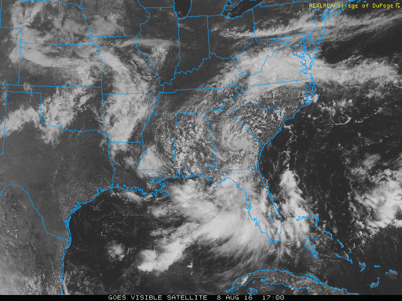
Nobody has mentioned this, but the size of this system is quite remarkable. It reaches from Kentucky to the Caribbean. I agree that it looks like all potential for development is gone, but there are multiple MLCs rotating around within the larger circulation. If it continues to stew over the super warm gulf water, who knows... At least It's been interesting to watch.
Nobody has mentioned this, but the size of this system is quite remarkable. It reaches from Kentucky to the Caribbean. I agree that it looks like all potential for development is gone, but there are multiple MLCs rotating around within the larger circulation. If it continues to stew over the super warm gulf water, who knows... At least It's been interesting to watch.
2 likes
-
Stormcenter
- S2K Supporter
- Posts: 6689
- Joined: Wed Sep 03, 2003 11:27 am
- Location: Houston, TX
Re: Northeastern Gulf of Mexico
Never say never when it involves the tropics, just saying. IMO
2 likes
Re: Northeastern Gulf of Mexico
psyclone wrote:Overall this has not been a big deal compared to the potential that appeared to exist a few days ago...which was a redux of last year's inundation. We've seen nothing like that and we should consider ourselves lucky. ..take a look at the rain estimates on the Tampa radar and you'll see just how close of a shave it was. Now that things are saturated due to previous rain and low evaporative losses, any additional heavy rain will quickly translate into pure runoff and things could stack up quickly...but absent that it appears we may have dodged a bullet here in west central florida...still some time to wait and be vigilant though.
I consider myself lucky but for the folks that had their houses flooded in Pasco, I'm sure they're not feeling the same way
0 likes
-
TheStormExpert

-
Dean4Storms
- S2K Supporter
- Posts: 6358
- Age: 63
- Joined: Sun Aug 31, 2003 1:01 pm
- Location: Miramar Bch. FL
Re: Northeastern Gulf of Mexico
The highest sustained and gusting winds reported at this buoy just past hour.....
http://www.ndbc.noaa.gov/station_page.php?station=42036
http://www.ndbc.noaa.gov/station_page.php?station=42036
1 likes
-
Dean4Storms
- S2K Supporter
- Posts: 6358
- Age: 63
- Joined: Sun Aug 31, 2003 1:01 pm
- Location: Miramar Bch. FL
Re: Northeastern Gulf of Mexico
And another buoy just west of 40236....
Now this is strange.
http://www.ndbc.noaa.gov/station_page.php?station=42039
Now this is strange.
http://www.ndbc.noaa.gov/station_page.php?station=42039
1 likes
-
gulf701
- Tropical Depression

- Posts: 65
- Age: 76
- Joined: Mon Jun 14, 2010 4:43 pm
- Location: Wewahitchka, FL
Re: Northeastern Gulf of Mexico
For anyone who tried access the Davis Weather site at http://www.weatherlink.com/user/saintjoebeach/, we have experienced several uncommon power failures. As the one who maintains the system and being out of town, I had to walk another member to reset the internet. As of this posting, it is working.
0 likes
-
vbhoutex

- Storm2k Executive

- Posts: 29148
- Age: 74
- Joined: Wed Oct 09, 2002 11:31 pm
- Location: Cypress, TX
- Contact:
Re: Northeastern Gulf of Mexico
It is a very large system and it still has a lot of very warm water to work with. However, with the system inland it is very unlikely anything more will come of it except more rains till it starts to move away. When it first appeared on radars and move offshore, I was concerned that it could be an Alicia "83 but the pattern wasn't there for that to happen thankfully.canefan wrote:Hi all. New to the board.
Nobody has mentioned this, but the size of this system is quite remarkable. It reaches from Kentucky to the Caribbean. I agree that it looks like all potential for development is gone, but there are multiple MLCs rotating around within the larger circulation. If it continues to stew over the super warm gulf water, who knows... At least It's been interesting to watch.
https://i.gyazo.com/0fea482c34a10c6f548 ... 6a5005.gif
2 likes
Skywarn, C.E.R.T.
Please click below to donate to STORM2K to help with the expenses of keeping the site going:

Please click below to donate to STORM2K to help with the expenses of keeping the site going:

Re: Northeastern Gulf of Mexico
NDG wrote:Over land but still very impressive.
Super cool on the visible. It's an atypical surface pattern of broad rotation with embedded lower level swirls which is luckily inland. I'm waiting to see as that high builds in off the SE coast if there isn't a blowup off the Panhandle tonight or tomorrow and a new surface low. Local NWS offices have been moving the rain threat farther west, and NOLA has us under a 5-8" threat Wed thru Sunday. That could be conservative in coastal areas, but I think southern Mississippi and southern Alabama will get more rain than here. Noted that for whatever reason 18z GFS has lake pontchartrain among the higher rainfall total areas. Nam 00z has the bulk of its rainfall in the next few days in southern MS and just offshore of MS/LA in the chandeleur islands.
inland or otherwise, it's still going to be a cool pattern to watch. Usually we don't have cut off or independent, not-necessarily-tropical low pressure milling around in the summer. How far west will the general area get before the pattern lifts out?
1 likes
-
stormwise

-
tropicwatch

- Category 5

- Posts: 3426
- Age: 62
- Joined: Sat Jun 02, 2007 10:01 am
- Location: The Villages, Florida
- Contact:
Re: Northeastern Gulf of Mexico
Interesting little feature south of the panhandle. Pressures in the area are around 1010-1011mb's.

0 likes
Tropicwatch
Agnes 72', Eloise 75, Elena 85', Kate 85', Charley 86', Florence 88', Beryl 94', Dean 95', Erin 95', Opal 95', Earl 98', Georges 98', Ivan 2004', Arlene 2005', Dennis 2005', Ida 2009' Debby 2012' Irma 2017' Michael 2018'
Agnes 72', Eloise 75, Elena 85', Kate 85', Charley 86', Florence 88', Beryl 94', Dean 95', Erin 95', Opal 95', Earl 98', Georges 98', Ivan 2004', Arlene 2005', Dennis 2005', Ida 2009' Debby 2012' Irma 2017' Michael 2018'
-
Stormcenter
- S2K Supporter
- Posts: 6689
- Joined: Wed Sep 03, 2003 11:27 am
- Location: Houston, TX
Re: Northeastern Gulf of Mexico
Convection starting to blossom again in the GOM.
http://www.ssd.noaa.gov/goes/east/gmex/h5-loop-vis.html
http://www.ssd.noaa.gov/goes/east/gmex/h5-loop-vis.html
1 likes
Who is online
Users browsing this forum: No registered users and 412 guests