Gulf Coast Disturbance (early August)
Moderator: S2k Moderators
Forum rules

The posts in this forum are NOT official forecasts and should not be used as such. They are just the opinion of the poster and may or may not be backed by sound meteorological data. They are NOT endorsed by any professional institution or STORM2K. For official information, please refer to products from the National Hurricane Center and National Weather Service.


Re: Northeastern Gulf of Mexico
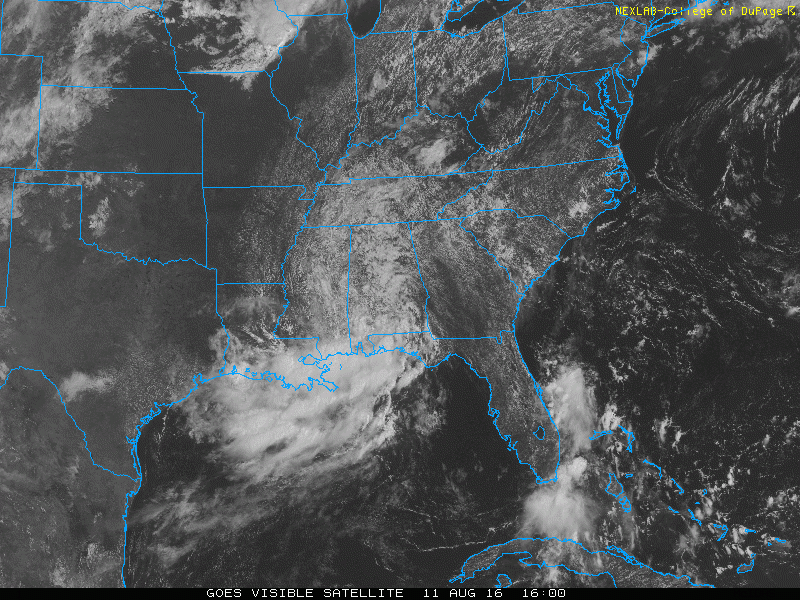
Looks like another good sized spin up a good distance from the main broad low a couple hundred miles south of panama city. You can see it in the visible, enhanced and radar.
1 likes

Re: Northeastern Gulf of Mexico
Saw a tv radar model on wdsu which showed the main circulation around Pearlington, MS. it shoots a surface low north around 90W but spins a ton of energy around here. However more gets left back and continues west toward SW LA/SE TX coasts though it's unclear how far the energy can get and whether it spins up a surface low in the NW Gulf or remains a general broad area of low pressure. I still think S MS takes the brunt of the rainfall over the next 36 hours or so. I saw where there was a 20+ Doppler just offshore of the LA coast today, so people are going to get wet.
0 likes


Re: Northeastern Gulf of Mexico
They've finally removed it (again  ) from being mentioned in the TWO:

0 likes


Re: Northeastern Gulf of Mexico
Today our bad weather is really supposed to kick in here in coastal Mississippi. I have to get out in it because my 5th grandchild is arriving by Cesarean about noon today. May have to nickname her Stormy.

1 likes
-
wxman57

- Moderator-Pro Met

- Posts: 23174
- Age: 68
- Joined: Sat Jun 21, 2003 8:06 pm
- Location: Houston, TX (southwest)
Re: Northeastern Gulf of Mexico
Nothing but rain from this system. Development chances are near zero. Perhaps some of this rain will reach SE TX over the next few days. It's been a bit dry here lately.
3 likes
-
lrak

- S2K Supporter

- Posts: 1770
- Age: 59
- Joined: Thu Jun 21, 2007 2:48 pm
- Location: Corpus Christi, TX
Re: Northeastern Gulf of Mexico
That sounds like a great name, congratulations 
0 likes
AKA karl
Also
Personal Forecast Disclaimer:
My posts on this forum are NOT official forecast and should not be used as such. My posts are my basic observations and are definitely not backed by any "well some" meteorological knowledge. For official information, please refer to the NHC and NWS products.
Also
Personal Forecast Disclaimer:
My posts on this forum are NOT official forecast and should not be used as such. My posts are my basic observations and are definitely not backed by any "well some" meteorological knowledge. For official information, please refer to the NHC and NWS products.
-
lrak
- S2K Supporter
- Posts: 1770
- Age: 59
- Joined: Thu Jun 21, 2007 2:48 pm
- Location: Corpus Christi, TX
Re: Northeastern Gulf of Mexico
wxman57 wrote:Nothing but rain from this system. Development chances are near zero. Perhaps some of this rain will reach SE TX over the next few days. It's been a bit dry here lately.
You think we may get some too wxman57?
0 likes
AKA karl
Also
Personal Forecast Disclaimer:
My posts on this forum are NOT official forecast and should not be used as such. My posts are my basic observations and are definitely not backed by any "well some" meteorological knowledge. For official information, please refer to the NHC and NWS products.
Also
Personal Forecast Disclaimer:
My posts on this forum are NOT official forecast and should not be used as such. My posts are my basic observations and are definitely not backed by any "well some" meteorological knowledge. For official information, please refer to the NHC and NWS products.
Re: Northeastern Gulf of Mexico
lrak wrote:wxman57 wrote:Nothing but rain from this system. Development chances are near zero. Perhaps some of this rain will reach SE TX over the next few days. It's been a bit dry here lately.
You think we may get some too wxman57?
Hey Karl,
It depends. Models diverge. The 06Z NAM 84 hour precipitation total seems to indicate most of the moisture is north and east of me. It's been pretty good with this system since it was in Appalachee Bay.. I'm waiting for the 12z to come out in a few minutes to see if it moved towards what the GFS was saying at 06Z. GFS 06Z 84 Hour run has about 4-5" in metro Houston, and 15-20" falling in South Central, Louisiana (Houma, Morgan City) in the next day or two. GFS continues the piece of energy offshore in the NW Gulf and migrates it westward. 12z NAM should be out in 5 minutes or so.
Edit to say that the 12Z NAM maintains the bulk of the rainfall in SE MS. Parts of Hancock and Harrison Counties, Mississippi and a bunch of parishes west and south of New Orleans are currently under flash flood warnings (Terrebonne, Lafourche, St. Charles, St. John, St. James, Ascension etc.). Diamondhead, MS had 6+ already, and Pass Christian, 4"+. Being that NAM supports South MS and GFS supports SC LA, it's undetermined whether this can get closer to Texas or not.
0 likes
-
MGC

- S2K Supporter
- Posts: 5940
- Joined: Sun Mar 23, 2003 9:05 pm
- Location: Pass Christian MS, or what is left.
Re: Northeastern Gulf of Mexico
Steve, I'd say the 12Z NAM has verified here in Pass Christian. Just ventured outside and dumped the gauge, 7 1/2 inches of rain and its still coming down at a steady pace. Just glanced at the radar and I think another couple of hours rain for me.....MGC
2 likes
-
wxman57
- Moderator-Pro Met
- Posts: 23174
- Age: 68
- Joined: Sat Jun 21, 2003 8:06 pm
- Location: Houston, TX (southwest)
Re: Northeastern Gulf of Mexico
lrak wrote:wxman57 wrote:Nothing but rain from this system. Development chances are near zero. Perhaps some of this rain will reach SE TX over the next few days. It's been a bit dry here lately.
You think we may get some too wxman57?
It may be difficult for the rain to reach the desert of south Texas. However, the 12Z GFS does indicate some rain down your way by Sunday.
1 likes


Re: Northeastern Gulf of Mexico
I concur... things don't look promising for deep south Texas at the moment.
1 likes
Anything I post is my personal opinion and should not used for any type of planning or lifesaving reasons. Please refer to National Weather Service forecasts.

Re: Northeastern Gulf of Mexico
6 to 8 inch totals in the last 3 hrs. in the western portion of my Parrish but only sprinkles here. This is the wettest summer I can remember.
0 likes
The following post is NOT an official forecast and should not be used as such. It is just the opinion of the poster and may or may not be backed by sound meteorological data. It is NOT endorsed by any professional institution including storm2k.org For Official Information please refer to the NHC and NWS products.
-
lrak
- S2K Supporter
- Posts: 1770
- Age: 59
- Joined: Thu Jun 21, 2007 2:48 pm
- Location: Corpus Christi, TX
Re: Northeastern Gulf of Mexico
Steve wrote:lrak wrote:wxman57 wrote:Nothing but rain from this system. Development chances are near zero. Perhaps some of this rain will reach SE TX over the next few days. It's been a bit dry here lately.
You think we may get some too wxman57?
Hey Karl,
It depends. Models diverge. The 06Z NAM 84 hour precipitation total seems to indicate most of the moisture is north and east of me. It's been pretty good with this system since it was in Appalachee Bay.. I'm waiting for the 12z to come out in a few minutes to see if it moved towards what the GFS was saying at 06Z. GFS 06Z 84 Hour run has about 4-5" in metro Houston, and 15-20" falling in South Central, Louisiana (Houma, Morgan City) in the next day or two. GFS continues the piece of energy offshore in the NW Gulf and migrates it westward. 12z NAM should be out in 5 minutes or so.
Edit to say that the 12Z NAM maintains the bulk of the rainfall in SE MS. Parts of Hancock and Harrison Counties, Mississippi and a bunch of parishes west and south of New Orleans are currently under flash flood warnings (Terrebonne, Lafourche, St. Charles, St. John, St. James, Ascension etc.). Diamondhead, MS had 6+ already, and Pass Christian, 4"+. Being that NAM supports South MS and GFS supports SC LA, it's undetermined whether this can get closer to Texas or not.
Yippy!
0 likes
AKA karl
Also
Personal Forecast Disclaimer:
My posts on this forum are NOT official forecast and should not be used as such. My posts are my basic observations and are definitely not backed by any "well some" meteorological knowledge. For official information, please refer to the NHC and NWS products.
Also
Personal Forecast Disclaimer:
My posts on this forum are NOT official forecast and should not be used as such. My posts are my basic observations and are definitely not backed by any "well some" meteorological knowledge. For official information, please refer to the NHC and NWS products.
-
lrak
- S2K Supporter
- Posts: 1770
- Age: 59
- Joined: Thu Jun 21, 2007 2:48 pm
- Location: Corpus Christi, TX
Re: Northeastern Gulf of Mexico
wxman57 wrote:lrak wrote:wxman57 wrote:Nothing but rain from this system. Development chances are near zero. Perhaps some of this rain will reach SE TX over the next few days. It's been a bit dry here lately.
You think we may get some too wxman57?
It may be difficult for the rain to reach the desert of south Texas. However, the 12Z GFS does indicate some rain down your way by Sunday.
Awesome!
0 likes
AKA karl
Also
Personal Forecast Disclaimer:
My posts on this forum are NOT official forecast and should not be used as such. My posts are my basic observations and are definitely not backed by any "well some" meteorological knowledge. For official information, please refer to the NHC and NWS products.
Also
Personal Forecast Disclaimer:
My posts on this forum are NOT official forecast and should not be used as such. My posts are my basic observations and are definitely not backed by any "well some" meteorological knowledge. For official information, please refer to the NHC and NWS products.
Re: Northeastern Gulf of Mexico
tailgater wrote:6 to 8 inch totals in the last 3 hrs. in the western portion of my Parrish but only sprinkles here. This is the wettest summer I can remember.
That's what's so different than 1998 which was incredibly hot and dry here in the summer. I remember that year distinctly based on Frances and Georges, but more specifically, as noted before, as that was the year I learned what "Wasping" was. That's kids with tennis rackets vs. wasps everywhere. They love it hot and dry, and they were pretty thick that year.
mgc,
looks like after this batch dies down, more will hit later or tomorrow and last for a couple more days. NAM 12Z shows the low right along the MS/LA border and then a second one just west of there in a day or two. Looks like another 5+ isn't out of the question for you all.
lrak,
What's funny about South Texas, is that the NAM brings that wave just east of Florida directly toward you all by way of the Yucatan. It's the NAM, so big crystal of salt is to be taken with that. I figured that energy would sort of get stretched out and hit the SC coast after it was clear it wasn't going to develop. This looks like southern energy from that system heading straight for you. It's still a little early in August, but I'm wondering if that can't crank out a surface low on its way. Stay tuned the next 3-4 days.
1 likes
-
lrak
- S2K Supporter
- Posts: 1770
- Age: 59
- Joined: Thu Jun 21, 2007 2:48 pm
- Location: Corpus Christi, TX
Re: Northeastern Gulf of Mexico
Steve wrote:tailgater wrote:6 to 8 inch totals in the last 3 hrs. in the western portion of my Parrish but only sprinkles here. This is the wettest summer I can remember.
That's what's so different than 1998 which was incredibly hot and dry here in the summer. I remember that year distinctly based on Frances and Georges, but more specifically, as noted before, as that was the year I learned what "Wasping" was. That's kids with tennis rackets vs. wasps everywhere. They love it hot and dry, and they were pretty thick that year.
mgc,
looks like after this batch dies down, more will hit later or tomorrow and last for a couple more days. NAM 12Z shows the low right along the MS/LA border and then a second one just west of there in a day or two. Looks like another 5+ isn't out of the question for you all.
lrak,
What's funny about South Texas, is that the NAM brings that wave just east of Florida directly toward you all by way of the Yucatan. It's the NAM, so big crystal of salt is to be taken with that. I figured that energy would sort of get stretched out and hit the SC coast after it was clear it wasn't going to develop. This looks like southern energy from that system heading straight for you. It's still a little early in August, but I'm wondering if that can't crank out a surface low on its way. Stay tuned the next 3-4 days.
I will Steve Thanks!
1 likes
AKA karl
Also
Personal Forecast Disclaimer:
My posts on this forum are NOT official forecast and should not be used as such. My posts are my basic observations and are definitely not backed by any "well some" meteorological knowledge. For official information, please refer to the NHC and NWS products.
Also
Personal Forecast Disclaimer:
My posts on this forum are NOT official forecast and should not be used as such. My posts are my basic observations and are definitely not backed by any "well some" meteorological knowledge. For official information, please refer to the NHC and NWS products.


Re: Northeastern Gulf of Mexico
Looks like it won't develop (no surprise here). But is causing a lot of rain on the panhandle, Mississippi, and in Alabama.
0 likes
Igor 2010, Sandy 2012, Fay 2014, Gonzalo 2014, Joaquin 2015, Nicole 2016, Humberto 2019, Imelda 2025
I am only a tropical weather enthusiast. My predictions are not official and may or may not be backed by sound meteorological data. For official information, please refer to the NHC and NWS products.
I am only a tropical weather enthusiast. My predictions are not official and may or may not be backed by sound meteorological data. For official information, please refer to the NHC and NWS products.

Re: Northeastern Gulf of Mexico
This low pressure area has had a very good UL divergence over the last couple of days or so thus why it has kepted a very good cyclonic organization even inland.
2 likes

Re: Northeastern Gulf of Mexico
Given how well this held together over land with the upper environment I'd hate to see what we would've had if it made it over water.
2 likes
The above post is not official and should not be used as such. It is the opinion of the poster and may or may not be backed by sound meteorological data. It is not endorsed by any professional institution or storm2k.org. For official information, please refer to the NHC and NWS products.
Who is online
Users browsing this forum: No registered users and 91 guests