ATL: FIONA - Post-Tropical - Discussion
Moderator: S2k Moderators
-
TheStormExpert
Re: ATL: INVEST 98L - Discussion
It's no wonder the 00z Euro does little to anything with 98L, it sends it NW directly into the SAL and Mid-Leve dry air.
1 likes
-
znel52
Re: ATL: INVEST 98L - Discussion
I think the main issue for development in the short term is forward speed and not as much SAL. SAL definitely isn't helping but models have been showing this will have a nice moist inflow coming from the itcz. It's just my opinion but I think the real inhibiting factor will be forward speed. Gonna have a tough time closing an LLC moving west at 24mph. If this was moving at 15mph we probably have a classifiable system right now.
0 likes
-
cycloneye

- Admin

- Posts: 149389
- Age: 69
- Joined: Thu Oct 10, 2002 10:54 am
- Location: San Juan, Puerto Rico
Re: ATL: INVEST 98L - Discussion
No closed circulation yet.

1 likes
Visit the Caribbean-Central America Weather Thread where you can find at first post web cams,radars
and observations from Caribbean basin members Click Here
and observations from Caribbean basin members Click Here
-
TheStormExpert
Re: ATL: INVEST 98L - Discussion
znel52 wrote:TheStormExpert wrote:tarheelprogrammer wrote:
Very strong. SAL is just not going away so far this season. Every time there is a break you see another surge of it quickly.
It's no wonder the 00z Euro does little to anything with 98L, it sends it NW directly into the SAL and Mid-Leve dry air.
I think the main issue for development in the short term is forward speed and not as much SAL. SAL definitely isn't helping but models have been showing this will have a nice moist inflow coming from the itcz. It's just my opinion but I think the real inhibiting factor will be forward speed. Gonna have a tough time closing an LLC moving west at 24mph. If this was moving at 15mph we probably have a classifiable system right now.
You're right about that! The foward speed of these waves and pre-Earl this season have been abnormally fast for whatever reason, does not seem normal.
0 likes

Re: ATL: INVEST 98L - Discussion
TheStormExpert wrote:znel52 wrote:TheStormExpert wrote:It's no wonder the 00z Euro does little to anything with 98L, it sends it NW directly into the SAL and Mid-Leve dry air.
I think the main issue for development in the short term is forward speed and not as much SAL. SAL definitely isn't helping but models have been showing this will have a nice moist inflow coming from the itcz. It's just my opinion but I think the real inhibiting factor will be forward speed. Gonna have a tough time closing an LLC moving west at 24mph. If this was moving at 15mph we probably have a classifiable system right now.
You're right about that! The foward speed of these waves and pre-Earl this season have been abnormally fast for whatever reason, does not seem normal.
Weird. Maybe trade winds are stronger than usual, and are increasing the forward speeds of these storms?
0 likes
Igor 2010, Sandy 2012, Fay 2014, Gonzalo 2014, Joaquin 2015, Nicole 2016, Humberto 2019, Imelda 2025
I am only a tropical weather enthusiast. My predictions are not official and may or may not be backed by sound meteorological data. For official information, please refer to the NHC and NWS products.
I am only a tropical weather enthusiast. My predictions are not official and may or may not be backed by sound meteorological data. For official information, please refer to the NHC and NWS products.
-
znel52
Re: ATL: INVEST 98L - Discussion
Kazmit_ wrote:TheStormExpert wrote:znel52 wrote:
I think the main issue for development in the short term is forward speed and not as much SAL. SAL definitely isn't helping but models have been showing this will have a nice moist inflow coming from the itcz. It's just my opinion but I think the real inhibiting factor will be forward speed. Gonna have a tough time closing an LLC moving west at 24mph. If this was moving at 15mph we probably have a classifiable system right now.
You're right about that! The foward speed of these waves and pre-Earl this season have been abnormally fast for whatever reason, does not seem normal.
Weird. Maybe trade winds are stronger than usual, and are increasing the forward speeds of these storms?
Yeah that is my understanding. Someone please feel free to correct me if I am off base but the reason is strong easterly trades. That has been the case the last few seasons. A few stroms have managed to pop during brief windows when the winds back off some but they have been few and far between.
1 likes

Re: ATL: INVEST 98L - Discussion
On this other image it does show a show a closed circulation but it is still elongated SW-NE. IMO.
1 likes
-
gatorcane

- S2K Supporter

- Posts: 23708
- Age: 48
- Joined: Sun Mar 13, 2005 3:54 pm
- Location: Boca Raton, FL
Re: ATL: INVEST 98L - Models
12Z Guidance. 98l is tracking more to the left of the guidance so far (see dotted black line):

0 likes
Re: ATL: INVEST 98L - Discussion
znel52 wrote:Kazmit_ wrote:TheStormExpert wrote:You're right about that! The foward speed of these waves and pre-Earl this season have been abnormally fast for whatever reason, does not seem normal.
Weird. Maybe trade winds are stronger than usual, and are increasing the forward speeds of these storms?
Yeah that is my understanding. Someone please feel free to correct me if I am off base but the reason is strong easterly trades. That has been the case the last few seasons. A few stroms have managed to pop during brief windows when the winds back off some but they have been few and far between.
Easterly trade winds have actually been below average the past couple weeks across the tropical Atlantic, except central Caribbean. The models are persistent that the forward speed of 98L will slow down and take a more NW track indicative of a weakening subtropical high.

1 likes
-
znel52
Re: ATL: INVEST 98L - Discussion
NDG wrote:znel52 wrote:Kazmit_ wrote:Weird. Maybe trade winds are stronger than usual, and are increasing the forward speeds of these storms?
Yeah that is my understanding. Someone please feel free to correct me if I am off base but the reason is strong easterly trades. That has been the case the last few seasons. A few stroms have managed to pop during brief windows when the winds back off some but they have been few and far between.
Easterly trade winds have actually been below average the past couple weeks across the tropical Atlantic, except central Caribbean. The models are persistent that the forward speed of 98L will slow down and take a more NW track indicative of a weakening subtropical high.
Interesting thanks for the info!
0 likes
-
wxman57

- Moderator-Pro Met

- Posts: 23173
- Age: 68
- Joined: Sat Jun 21, 2003 8:06 pm
- Location: Houston, TX (southwest)
Re: ATL: INVEST 98L - Discussion
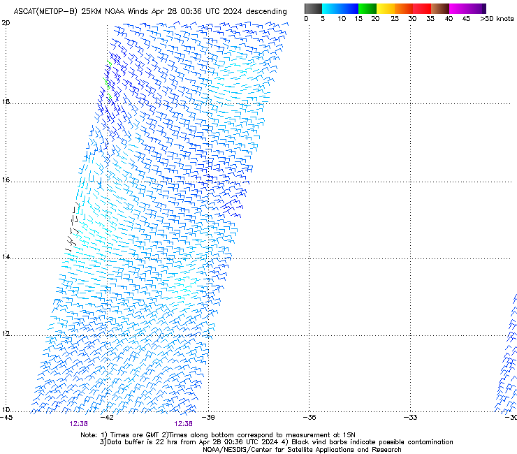
Got a 12Z ASCAT pass over it. LLC evident a bit south of 11N around 31W. I'd estimate a 15Z position of 11.3N/31.8W. Doesn't qualify for a TD yet, as the circulation is a bit too poorly-organized (though it's better than Colin's was...).
1 likes

Re: ATL: INVEST 98L - Discussion
Classic sharp wave, almost looks like a shark fin, also it looks like there isn't any weakness in the subtropical ridging yet?
0 likes

-
gatorcane
- S2K Supporter
- Posts: 23708
- Age: 48
- Joined: Sun Mar 13, 2005 3:54 pm
- Location: Boca Raton, FL
Re: ATL: INVEST 98L - Models
12Z GFS really bombs this out with what looks like a run at a MAJOR hurricane as it recurves in the Central Atlantic.
0 likes
Re: ATL: INVEST 98L - Discussion
wxman57 wrote:Got a 12Z ASCAT pass over it. LLC evident a bit south of 11N around 31W. I'd estimate a 15Z position of 11.3N/31.8W. Doesn't qualify for a TD yet, as the circulation is a bit too poorly-organized (though it's better than Colin's was...).
]
Do you still think like you thought early yesterday that its most likely outcome is no development anytime soon thus allowing it to move westward into the Caribbean?
0 likes
Personal Forecast Disclaimer:
The posts in this forum are NOT official forecasts and should not be used as such. They are just the opinion of the poster and may or may not be backed by sound meteorological data. They are NOT endorsed by any professional institution or storm2k.org. For official information, please refer to the NHC and NWS products.
The posts in this forum are NOT official forecasts and should not be used as such. They are just the opinion of the poster and may or may not be backed by sound meteorological data. They are NOT endorsed by any professional institution or storm2k.org. For official information, please refer to the NHC and NWS products.
-
Blown Away

- S2K Supporter
- Posts: 10253
- Joined: Wed May 26, 2004 6:17 am
Re: ATL: INVEST 98L - Models
All aboard the recurve train per the 12z GFS... Big giant hole in Atlantic to move these lows far away from land, maybe Bermuda... Looks like some healthy systems to watch with the fish...
http://www.tropicaltidbits.com/analysis ... 0&ypos=220
http://www.tropicaltidbits.com/analysis ... 0&ypos=220
1 likes
Hurricane Eye Experience: David 79, Irene 99, Frances 04, Jeanne 04, Wilma 05… Hurricane Brush Experience: Andrew 92, Erin 95, Floyd 99, Matthew 16, Irma 17, Ian 22, Nicole 22…
-
Hurricaneman

- Category 5

- Posts: 7404
- Age: 45
- Joined: Tue Aug 31, 2004 3:24 pm
- Location: central florida
Re: ATL: INVEST 98L - Models
Blown Away wrote:All aboard the recurve train per the 12z GFS... Big giant hole in Atlantic to move these lows far away from land, maybe Bermuda... Looks like some healthy systems to watch with the fish...
http://www.tropicaltidbits.com/analysis ... 0&ypos=220
But one thing is I do believe this is a recurve but the one behind it is no guarantee due to being in the long range but I do agree this may be a picturesque major bothering nobody but the fish
The posts in this forum are NOT official forecast and should not be used as such. They are just the opinion of the poster and may or may not be backed by sound meteorological data. They are NOT endorsed by any professional institution or STORM2K. For official information, please refer to products from the National Hurricane Center and National Weather Service
1 likes
-
Hurricaneman
- Category 5
- Posts: 7404
- Age: 45
- Joined: Tue Aug 31, 2004 3:24 pm
- Location: central florida
Re: ATL: INVEST 98L - Discussion
This looks well on its way, but the northern end is dealing with dry air
The posts in this forum are NOT official forecast and should not be used as such. They are just the opinion of the poster and may or may not be backed by sound meteorological data. They are NOT endorsed by any professional institution or STORM2K. For official information, please refer to products from the National Hurricane Center and National Weather Service
The posts in this forum are NOT official forecast and should not be used as such. They are just the opinion of the poster and may or may not be backed by sound meteorological data. They are NOT endorsed by any professional institution or STORM2K. For official information, please refer to products from the National Hurricane Center and National Weather Service
0 likes
-
cycloneye
- Admin
- Posts: 149389
- Age: 69
- Joined: Thu Oct 10, 2002 10:54 am
- Location: San Juan, Puerto Rico
Re: ATL: INVEST 98L - Discussion
If the models are right and this system tracks thru fairly good conditions,it may get a good chunck of ACE units that the North Atlantic needs as is below normal to this date. (10.915 units so far)
0 likes
Visit the Caribbean-Central America Weather Thread where you can find at first post web cams,radars
and observations from Caribbean basin members Click Here
and observations from Caribbean basin members Click Here
Who is online
Users browsing this forum: No registered users and 99 guests