WPAC: CHANTHU - Post-Tropical
Moderator: S2k Moderators
Re: WPAC: TROPICAL STORM CHANTHU
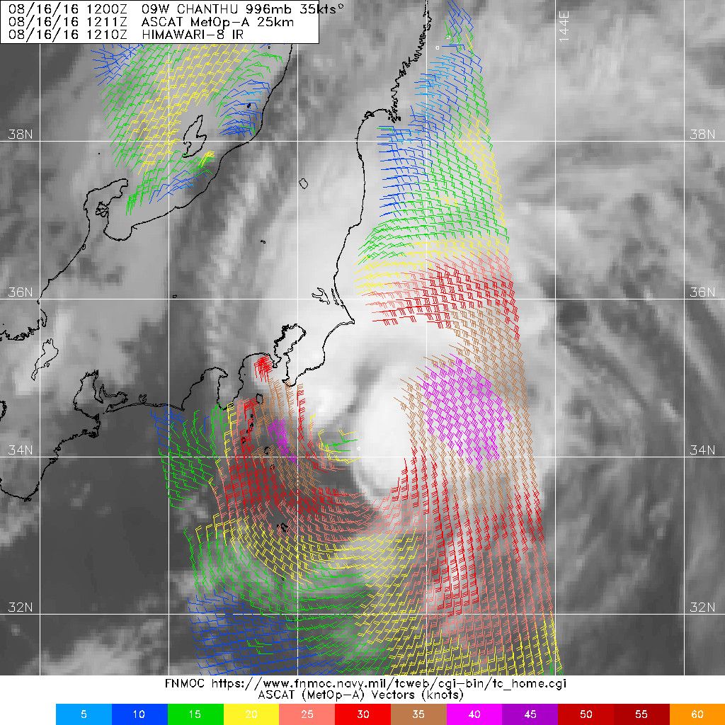
Maybe the JTWC should take a look at the ASCAT data. Their intensity and position estimates seem inaccurate.
0 likes
Personal Forecast Disclaimer:
The posts in this forum are NOT official forecast and should not be used as such. They are just the opinion of the poster and may or may not be backed by sound meteorological data. They are NOT endorsed by any professional institution or storm2k.org. For official information, please refer to RSMC and NWS products.
The posts in this forum are NOT official forecast and should not be used as such. They are just the opinion of the poster and may or may not be backed by sound meteorological data. They are NOT endorsed by any professional institution or storm2k.org. For official information, please refer to RSMC and NWS products.

Re: WPAC: TROPICAL STORM CHANTHU
asking JT to look at data is like asking for a million dollars. It may happen, but chances are, it won't
0 likes
Re: WPAC: TROPICAL STORM CHANTHU
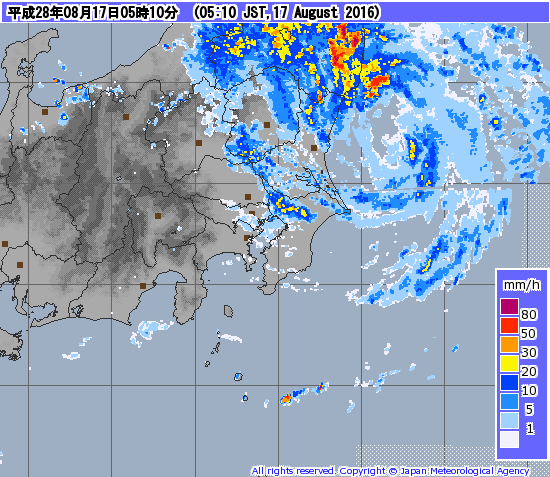
Radar presentation looks somewhat impressive. Lowest pressure recorded in Japan was 980.1mb. JMA at 980mb/45kt at 18Z.
0 likes
Personal Forecast Disclaimer:
The posts in this forum are NOT official forecast and should not be used as such. They are just the opinion of the poster and may or may not be backed by sound meteorological data. They are NOT endorsed by any professional institution or storm2k.org. For official information, please refer to RSMC and NWS products.
The posts in this forum are NOT official forecast and should not be used as such. They are just the opinion of the poster and may or may not be backed by sound meteorological data. They are NOT endorsed by any professional institution or storm2k.org. For official information, please refer to RSMC and NWS products.
-
euro6208
Re: WPAC: TROPICAL STORM CHANTHU

WDPN31 PGTW 162100
MSGID/GENADMIN/JOINT TYPHOON WRNCEN PEARL HARBOR HI//
SUBJ/PROGNOSTIC REASONING FOR TROPICAL STORM 09W (CHANTHU) WARNING
NR 15//
RMKS//
1. FOR METEOROLOGISTS.
2. 6 HOUR SUMMARY AND ANALYSIS.
TROPICAL STORM 09W (CHANTHU), LOCATED APPROXIMATELY 91 NM
NORTHEAST OF YOKOSUKA, JAPAN, HAS TRACKED NORTH-NORTHEASTWARD AT 10
KNOTS OVER THE PAST SIX HOURS. ANIMATED ENHANCED INFRARED SATELLITE
IMAGERY AND COMPOSITE RADAR FROM THE JAPAN METEOROLOGICAL AGENCY
DEPICT THE LOW-LEVEL CIRCULATION CENTER (LLCC) MOVING PARALLEL TO
THE COAST OF JAPAN. FLARING CONVECTION ASSOCIATED WITH THE LLCC IS
WEAKENING WITH ENHANCED POLEWARD OUTFLOW AS THE SYSTEM INTERACTS
WITH THE MID-LATITUDE FLOW AND BEGINS ITS EXTRATROPICAL TRANSITION.
THE INITIAL POSITION IS BASED ON RADAR IMAGERY WITH HIGH CONFIDENCE.
THE INITIAL INTENSITY IS BASED ON DVORAK INTENSITY ESTIMATES OF T2.5
FROM PGTW AND RJTD. ALTHOUGH POLEWARD UPPER-LEVEL OUTFLOW IS GOOD,
VERTICAL WIND SHEAR IS RAPIDLY INCREASING (25 TO 30 KNOTS) AS TS 09W
TRACKS ALONG THE WESTERN PERIPHERY OF A SUBTROPICAL RIDGE (STR) AND
TOWARD A MID-LATITUDE TROUGH TO THE NORTHWEST.
3. FORECAST REASONING.
A. NO CHANGE TO THE FORECAST PHILOSOPHY SINCE THE PREVIOUS
PROGNOSTIC REASONING MESSAGE.
B. TS 09W IS EXPECTED TO ACCELERATE TOWARD THE NORTH-
NORTHEAST AS IT BEGINS ITS EXTRATROPICAL TRANSITION AND BECOMES
INCREASINGLY EMBEDDED WITH THE 500 MB FLOW AHEAD OF THE APPROACHING
MID-LATITUDE TROUGH. TS 09W IS EXPECTED TO BECOME EXTRATROPICAL IN
APPROXIMATELY 24 HOURS. DYNAMIC MODEL GUIDANCE REMAINS IN TIGHT
AGREEMENT, LENDING HIGH CONFIDENCE TO THE CURRENT JTWC TRACK
FORECAST.//
NNNN
0 likes
-
1900hurricane

- Category 5

- Posts: 6063
- Age: 34
- Joined: Fri Feb 06, 2015 12:04 pm
- Location: Houston, TX
- Contact:
Re: WPAC: TROPICAL STORM CHANTHU
JMA is actually up to a 50 kt Severe Tropical Storm Chanthu.
1 likes
Contract Meteorologist. TAMU & MSST. Fiercely authentic, one of a kind. We are all given free will, so choose a life meant to be lived. We are the Masters of our own Stories.
Opinions expressed are mine alone.
Follow me on Twitter at @1900hurricane : Read blogs at https://1900hurricane.wordpress.com/
Opinions expressed are mine alone.
Follow me on Twitter at @1900hurricane : Read blogs at https://1900hurricane.wordpress.com/
-
AJC3

- Admin

- Posts: 4153
- Age: 62
- Joined: Tue Aug 31, 2004 7:04 pm
- Location: Ballston Spa, New York
- Contact:
Re: WPAC: TROPICAL STORM CHANTHU
I don't usually bag official forecasts, however the intensity analyses for the last two JTWC advisories were appallingly poor. 35KT?? Yikes. For the love of Pete, look at QS and the structure of the doggone thing! And making the 06Z advisory a final was also a REALLY poor decision.
Just...shocking.
Just...shocking.
0 likes
-
euro6208
Re: WPAC: TROPICAL STORM CHANTHU

WTPN31 PGTW 170300
MSGID/GENADMIN/JOINT TYPHOON WRNCEN PEARL HARBOR HI//
SUBJ/TROPICAL CYCLONE WARNING//
RMKS/
1. TROPICAL STORM 09W (CHANTHU) WARNING NR 016
01 ACTIVE TROPICAL CYCLONE IN NORTHWESTPAC
MAX SUSTAINED WINDS BASED ON ONE-MINUTE AVERAGE
WIND RADII VALID OVER OPEN WATER ONLY
---
WARNING POSITION:
170000Z --- NEAR 37.7N 141.6E
MOVEMENT PAST SIX HOURS - 010 DEGREES AT 15 KTS
POSITION ACCURATE TO WITHIN 030 NM
POSITION BASED ON CENTER LOCATED BY A COMBINATION OF
SATELLITE AND RADAR
PRESENT WIND DISTRIBUTION:
MAX SUSTAINED WINDS - 035 KT, GUSTS 045 KT
WIND RADII VALID OVER OPEN WATER ONLY
BECOMING EXTRATROPICAL
REPEAT POSIT: 37.7N 141.6E
---
FORECASTS:
12 HRS, VALID AT:
171200Z --- 43.4N 143.3E
MAX SUSTAINED WINDS - 035 KT, GUSTS 045 KT
WIND RADII VALID OVER OPEN WATER ONLY
EXTRATROPICAL
VECTOR TO 24 HR POSIT: 010 DEG/ 37 KTS
---
24 HRS, VALID AT:
180000Z --- 50.6N 145.4E
MAX SUSTAINED WINDS - 035 KT, GUSTS 045 KT
WIND RADII VALID OVER OPEN WATER ONLY
EXTRATROPICAL
---
REMARKS:
170300Z POSITION NEAR 39.1N 142.0E.
TROPICAL STORM 09W (CHANTHU), LOCATED APPROXIMATELY 171 NM NORTH-
NORTHEAST OF YOKOSUKA, JAPAN, HAS TRACKED AT 15 KNOTS OVER THE
PAST SIX HOURS.
THIS IS THE FINAL WARNING ON THIS SYSTEM BY THE JOINT TYPHOON
WRNCEN PEARL HARBOR HI. THE SYSTEM WILL BE CLOSELY MONITORED FOR
SIGNS OF REGENERATION. MAXIMUM SIGNIFICANT WAVE HEIGHT AT 170000Z
IS 13 FEET.
//
NNNN
0 likes
Re: WPAC: TROPICAL STORM CHANTHU
JMA up to 55kt/980hPa at 06Z. Chanthu will make landfall near Hokkaido soon.
0 likes
Personal Forecast Disclaimer:
The posts in this forum are NOT official forecast and should not be used as such. They are just the opinion of the poster and may or may not be backed by sound meteorological data. They are NOT endorsed by any professional institution or storm2k.org. For official information, please refer to RSMC and NWS products.
The posts in this forum are NOT official forecast and should not be used as such. They are just the opinion of the poster and may or may not be backed by sound meteorological data. They are NOT endorsed by any professional institution or storm2k.org. For official information, please refer to RSMC and NWS products.
Re: WPAC: TROPICAL STORM CHANTHU
Chanthu has made landfall near Cape Erimo, Hokkaido at 0830Z. Highest sustained winds reported were 30.9m/s from Kushiro. Even 55kt estimated by the JMA may be a bit low. And, of course, the intensity is MUCH higher than 35kt.
1 likes
Personal Forecast Disclaimer:
The posts in this forum are NOT official forecast and should not be used as such. They are just the opinion of the poster and may or may not be backed by sound meteorological data. They are NOT endorsed by any professional institution or storm2k.org. For official information, please refer to RSMC and NWS products.
The posts in this forum are NOT official forecast and should not be used as such. They are just the opinion of the poster and may or may not be backed by sound meteorological data. They are NOT endorsed by any professional institution or storm2k.org. For official information, please refer to RSMC and NWS products.
-
Kingarabian

- S2K Supporter

- Posts: 16348
- Joined: Sat Aug 08, 2009 3:06 am
- Location: Honolulu, Hawaii
Re: WPAC: TROPICAL STORM CHANTHU
Is the JTWC really run by the US Navy and USAF? Personally for me, it's hard to see two of the most prestigious branches of the U.S military would allow such an embarrassing product be repeatedly put out for public use.
A tropical cyclone is due to make landfall, potentially affecting a large population and they ignore raw data and science...
A tropical cyclone is due to make landfall, potentially affecting a large population and they ignore raw data and science...
0 likes
RIP Kobe Bryant
Re: WPAC: TROPICAL STORM CHANTHU
Chanthu is probably a borderline typhoon rather than a minimal tropical storm.
1 likes
Personal Forecast Disclaimer:
The posts in this forum are NOT official forecast and should not be used as such. They are just the opinion of the poster and may or may not be backed by sound meteorological data. They are NOT endorsed by any professional institution or storm2k.org. For official information, please refer to RSMC and NWS products.
The posts in this forum are NOT official forecast and should not be used as such. They are just the opinion of the poster and may or may not be backed by sound meteorological data. They are NOT endorsed by any professional institution or storm2k.org. For official information, please refer to RSMC and NWS products.
-
Typhoon Hunter
- WesternPacificWeather.com

- Posts: 1222
- Joined: Wed Oct 11, 2006 11:37 am
- Location: Tokyo
- Contact:
Re: WPAC: TROPICAL STORM CHANTHU
And it passed by a major Air Force base too, Misawa. No idea what JTWC are thinking. And talk of ground obs their estimate of pressure for Invest 95W is 1006hPa. All they need to do is look at coastal observations ie in Hong Kong where it's 992hPa to get a more accurate view. Very sloppy and amateur of them...
1 likes
Who is online
Users browsing this forum: No registered users and 36 guests